Showing 2331 items matching "city planning"
-
 Whitehorse Historical Society Inc.
Document, Morack Golf Course, 1/04/1993
... Morack Public Golf Course: Marketing Plan. City... Mitcham melbourne Morack Golf Course City of Nunawading Parks ...Morack Public Golf Course: Marketing Plan. City of Nunawading Parks and Recreations Services, April 1993morack golf course, city of nunawading, parks and reserves, abbott, kevin -
 Bendigo Historical Society Inc.
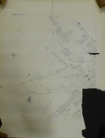
Document - MARKS COLLECTION: PLAN OF SANDHURST CITY CENTRE AND SURROUNDING AREA ( NO. 2 )
... MARKS COLLECTION: PLAN OF SANDHURST CITY CENTRE AND... into city centre) Plan shows allotments with owner names, where... for continuation of plan into city centre) Plan shows allotments with owner ...Plan drawn on heavy parchment. Written on plan Sandhurst Sheet No. 2. (See record 8300.58 for continuation of plan into city centre) Plan shows allotments with owner names, where applicable. Quartz crushing machines marked. On bottom lithographed at the Department of Lands and Survey, Melbourne, by D. Henerson, March 12th., 1867. There is also a photocopy.bendigo, planning, sandhurst -
Whitehorse Historical Society Inc.
Document, Vermont Reserve, 1/08/1992
... Vermont Reserve : Proposed Development Plan. City... and Reserves Vermont Reserve : Proposed Development Plan. City ...Vermont Reserve : Proposed Development Plan. City of Nunawading Parks and Recreation Services. Landscape Australia Consultants. August 1992.city of nunawading. parks and recreation services, vermont reserve, landscape australia consultants, parks and reserves -
Whitehorse Historical Society Inc.
Book, Socio-demographic facts and figures about Nunawading, 1984
... Detailed charts of figures, 1984 published by City... by City of Nunawading Strategic Planning Unit. Detailed charts ...Detailed charts of figures, 1984 published by City of Nunawading Strategic Planning Unit.Detailed charts of figures, 1984 published by City of Nunawading Strategic Planning Unit.Detailed charts of figures, 1984 published by City of Nunawading Strategic Planning Unit.local government, city of nunawading, population, statistics, demography -
 Glen Eira City Council History and Heritage Collection
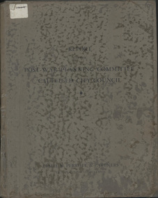
Book, "Report to the Post War Planning Committee, Caulfield City Council"
... "Report to the Post War Planning Committee, Caulfield City.... Perrott & Partners: (City Planning Consultants) and according... War Planning Committee Caulfield City Council". Interior pages... & Partners: (City Planning Consultants) and according to the report ...The Post War Planning Report was prepared by Leslie M. Perrott & Partners: (City Planning Consultants) and according to the report, it was submitted to the Council of the Municipality of Caulfield through its Special Committee on Post War Planning. The report has no evident date however the introduction text suggests that it was prepared before the end of World War II. The report is the only known extant copy and therefore considered rare. Bound report with grey cover titled: "Report to the Post War Planning Committee Caulfield City Council". Interior pages include x83 pages typed text printed on blue print paper; x3 pages copies of black and white photographs; 10 blueprint plans. 86 pages consistent in size with book cover, 10 x blueprint plans varying dimensions, folded and bound within the report. Printed on white sticker on spine of book "LH 994. 51" and on first page inside "CAULFIELD LIBRARY SERVICE REFERENCE BOOK" and on the verso of this page, another stamp with CAULFIELD LIBRARY SERVICE and LH REF 12/7 hand written in black ink and a 14 digit reference number below this. On the back of the last plan in the book, there is a blue stamp with "REFERENCE BOOK TO BE USED IN THE LIBRARY ONLY". Below this is a black and white barcode with a black line through it and a round, blue sticker beside it. -
Whitehorse Historical Society Inc.
Article, Staff morale low, 1993
... City of Nunawading Planning and development group staff... morale. City of Nunawading Planning and development group staff ...City of Nunawading Planning and development group staff experiencing a low morale.City of Nunawading Planning and development group staff experiencing a low morale. Ray Glickman, Group Manager, identifies future directions.City of Nunawading Planning and development group staff experiencing a low morale. city of nunawading, glickman, ray -
Whitehorse Historical Society Inc.
Document, Hale Property, 1/08/1992
... Hale Property : Draft management and development plan, City... Mitcham melbourne City of Nunawading. Parks and Recreation ...Hale Property : Draft management and development plan, City of Nunawading Parks and Recreation Services. Landscape Australia Consultants. August 1992.city of nunawading. parks and recreation services, landscape australia consultants, hale property, parks and reserves -
 Ringwood and District Historical Society
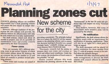
Newspaper, Scrapbook Clipping, Library Collection, Ringwood, Victoria
... Council planning officers are confident Maroondah City's... are confident Maroondah City's draft planning scheme will ensure ...Newspaper Clipping from "The Maroondah Post", 1/7/1997. Planning zones cutCouncil planning officers are confident Maroondah City's draft planning scheme will ensure the area retains its unique characteristics. The council officers believe its effectiveness will only be truly tested once it is fully implemented. -
Whitehorse Historical Society Inc.
Pamphlet, Socio demographic facts, figures for Nunawading City 1984, 1984
... City of Nunawading strategic planning - socio demographic... Mitcham melbourne Demography City of Nunawading Head Stephen City ...City of Nunawading strategic planning - socio demographic facts figures for 1984. Prepared by Stephen Head.City of Nunawading strategic planning - socio demographic facts figures for 1984. Prepared by Stephen Head.City of Nunawading strategic planning - socio demographic facts figures for 1984. Prepared by Stephen Head.demography, city of nunawading, head, stephen -
University of Melbourne, Burnley Campus Archives
Plan, St James Park Feature Plan, 1983
... City of Hawthorn Plan, drawing No P24/19, Sheet 1 of 1... City of Hawthorn Plan, drawing No P24/19, Sheet 1 of 1 ...City of Hawthorn Plan, drawing No P24/19, Sheet 1 of 1. Surveyed by L.B. & H.K. Traced by H.K. Aug 83. Scale 1:500.st james park, city of hawthorn, central gardens hawthorn -
Port Melbourne Historical & Preservation Society
Negative - Negative, Barak Road Development Area Services plan, City of Port Melbourne, City of Port Melbourne, Barak Road Development Area Services, 27 Sep 1971
... Negative, Barak Road Development Area Services plan, City...4" x 5" negative of City of Port Melbourne plan, Sept 1971... transport - railways town planning local government - city of port ...4" x 5" negative of City of Port Melbourne plan, Sept 1971, of services required for development between Barak and Beacon Roadstransport - railways, town planning, local government - city of port melbourne -
 Ringwood and District Historical Society
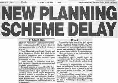
Newspaper, Scrapbook Clipping, Library Collection, Ringwood, Victoria, `
... undeterred.by a likely delay in implementing the city's draft planning... in implementing the city's draft planning scheme. Council last week moved ...``Newspaper clipping from the "Post", Tuesday February 17, 1998. NEW PLANNING SCHEME DELAY. By Peter Di SistoSenior Maroondah Council planning officers remain undeterred.by a likely delay in implementing the city's draft planning scheme. Council last week moved to ask Planning and Local Government Minister Rob Maclellan to appoint an independent panel to discuss submissions on its draft scheme, released for public comment last July. ` -
 Bendigo Historical Society Inc.
Ephemera - LYDIA CHANCELLOR COLLECTION: CORRESPONDENCE
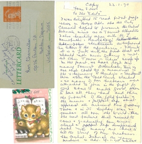
... ' and 'To the Editor.' The opinion piece is in relation to a Bendigo City....' The opinion piece is in relation to a Bendigo City Council plan ...An assortment of articles -(1) 2 Christmas gift cards to Mrs Chancellor, (2) 1 letter card to Mrs Chancellor from Carmel Dillon dated 19th February and, (3) A copy of a letter from Lydia Chancellor dated 22/01/1970 to ' Your views' and 'To the Editor.' The opinion piece is in relation to a Bendigo City Council plan to procure The Central Deborah Mine as a tourist attraction.communication, letters, lydia chancellor collection, correspondence, place, central deborah mine, gold mines, ephemera -
Melbourne Tram Museum
Newspaper, The Age, “City blocked: time to walk the walk”, 16/05/2019 12:00:00 AM
... Topsfield Melbourne City Council considers plan to transform... Melbourne City Council considers plan to transform Elizabeth St ...Newspaper clippings titled: “City blocked: time to walk the walk” Newspaper clipping from the Age 16/5/2019 by Jewel Topsfield Melbourne City Council considers plan to transform Elizabeth St into a more pedestrian and cyclist friendly precinct.trams, tramways, planning, melbourne, tram routes, elizabeth st -
Port Melbourne Historical & Preservation Society
Audio - Radio 3LO program excerpts, Sandridge City Development plan, 1991 - 1993
... Radio 3LO program excerpts, Sandridge City Development plan... BIRRELL about Sandridge City Development (Bayside Plan) Recording... Sandridge City Development (Bayside Plan) Recording duration 47:09 ...Various excerpts from 3LO radio prgrams, including Ranald McDONALD interviewing Jim KENNAN and Doug AITKEN interviewing Mark BIRRELL about Sandridge City Development (Bayside Plan) Recording duration 47:09. Approx 1991 and 1993town planning - proposals shelved - bayside, jim kennan, mark birrell, sandridge city development co pty ltd, scdc -
University of Melbourne, Burnley Campus Archives
Plan, Grace Park Feature Plan, 1901-1983
... (1) City of Hawthorn plan dated August 1983. Drawing No P12...hawthorn grace park (1) City of Hawthorn plan dated August ...(1) City of Hawthorn plan dated August 1983. Drawing No P12/24 Sheet 1 of 1. Surveyed: L.B. & H.K. Traced H.K. Scale 1:500. (2) Photocopy of map of area, Grace Park coloured in. 1901 handwritten on page.hawthorn, grace park -
University of Melbourne, Burnley Campus Archives
Plan, Barkly Gardens, c. 1980
... , plan by City of Richmond City Engineers Department....barkly gardens City of Richmond urban landscapes (1) Plan ...(1) Plan of park drawn in pencil on tracing paper. (2) 2 copies on tracing paper and 1 original on paper with 3 copies, plan by City of Richmond City Engineers Department.barkly gardens, city of richmond, urban landscapes -
Port Melbourne Historical & Preservation Society
Plan, John James Wild, Architect, New Town Hall Sandridge 1881, 1 Jan 1881
... Laminated copy from City collection, elevation plans... copy from City collection, elevation plans for new Town Hall ...Laminated copy from City collection, elevation plans for new Town Hall Sandridge 1881. .01 - front elevation .02 - rear elevation .03 - transverse section .04 - ground floor plan - A3 copy .05 - first floor plan - A3 copyarchitecture, port melbourne town hall, town clerks, built environment - civic, sandridge town hall, john james wild, edward clark -
University of Melbourne, Burnley Campus Archives
Plan, Circus Site, c. 1990
... (1) Copy of Plan: City of Richmond City Engineers... to Bridge Road." (1) Copy of Plan: City of Richmond City Engineers ...(1) Copy of Plan: City of Richmond City Engineers Department Circus Site: includes Descriptions of Site Preparation, Plant List and Plant Order List. (2) On tracing paper: Plant Plan. (3) On tracing paper: "Yarra Vegetation Survey - Site 3," Plant Plan(1) Handwritten on reverse, "Richmond Council - Yarra Blvd to Bridge Road."circus, survey, richmond, vegetation survey, colin mock, yarra river -
 Ringwood and District Historical Society
Document, Certificate of Title and miscellaneous property records - Carter Real Estate, 122 and 124-128 Maroondah Highway, Ringwood, Victoria
... , Entitlement Grant to a depth of fifteen metres - 29/1/1997, City... of fifteen metres - 29/1/1997, City of Ringwood planning permit ...Transfer of Land Act Title dated 24/4/2002 - Volume 10314 Folio 972 Crown Allotments 11H and 11J, Parish of Ringwood, Entitlement Grant to a depth of fifteen metres - 29/1/1997, City of Ringwood planning permit and diagram of office floor plan - 1973. -
 Ballarat Tramway Museum
Document - Report, West Coast Railway, "A preliminary evaluation report for Proposed Reinstatement of The Ballarat Tramway System", 21/04/1998 12:00:00 AM
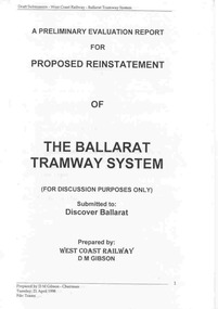
... structure of the tram system, tram types and marketing plan. City... and marketing plan. City Tramway. Document fully scanned 2/9/12 ...Twelve page document titled "A preliminary evaluation report for Proposed Reinstatement of The Ballarat Tramway System", prepared by Don Gibson of the West Coast Railway, dated 21/4/1998. Gives assumptions, discusses Business Objectives, suggested structure of the tram system, tram types and marketing plan. City Tramway. Document fully scanned 2/9/12. trams, tramways, ballarat city tramway, reports, west coast railway -
 Bendigo Historical Society Inc.
Plan - MERLE HALL COLLECTION: ROSALIND PARK CREATIVE VILLAGE BENDIGO PROJECT CONCEPT PLAN, 1993
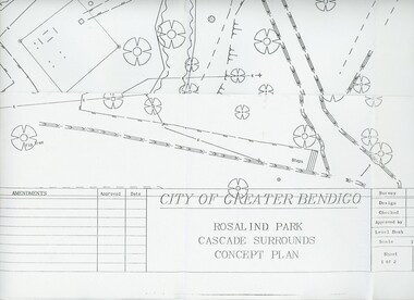
... BENDIGO PROJECT Concept Plan City of Greater Bendigo Rosalind... PROJECT Concept Plan City of Greater Bendigo Rosalind Park ...MERLE HALL COLLECTION: ROSALIND PARK CREATIVE VILLAGE BENDIGO PROJECT Concept Plan City of Greater Bendigo Rosalind Park Cascade Surrounds Concept Plan number GB095 Sheet 1 of 2 Level Book 365, Backup No Tape 01, Computer File No. ROS QEO. Large Sheet which shows the location of utilities, vegetation, drains, embankments etc. June 1993 -
 Melbourne Tram Museum
Pamphlet, P. Thomas, South Melbourne Depot, "Cross City Linking - A plan for the future or another PTC Fiasco????", c1992
... "Cross City Linking - A plan for the future or another PTC..., both sides, titled "Cross City Linking - A plan for the future... City Linking - A plan for the future or another PTC Fiasco ...Pamphlet, letter or notice - photocopy onto an A4 sheet, both sides, titled "Cross City Linking - A plan for the future or another PTC Fiasco????", looking at the proposed project , relationships with the Public Transport Users Association (PTUA), route changes, union actions, impacts of proposals and asking members to be involved in the proposal at South Melbourne Depot - c1992 See Reg Item 1535 for a report on this project.trams, tramways, the met, unions, south melbourne depot, management, ptc, routes, w class, operations, buses, ptua -
 Bendigo Historical Society Inc.
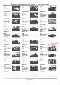
Book - MARONG HERITAGE STUDY
... and the recommendations for inclusion in the Heritage Overlay Table in the City... for inclusion in the Heritage Overlay Table in the City of Greater ...Eighty one loose pages stapled together. Marong Heritage Study: Index of Heritage Sites. First three pages identifies the various sites followed by an in depth description of each sites and the recommendations for inclusion in the Heritage Overlay Table in the City of Greater Bendigo Planning Scheme.bendigo, council, heritage study -
 Kew Historical Society Inc
Photograph - Flooding of the Yarra River in North Kew, 1934
... ) was limited by the City of Kew's planning regulations. Prior to urban...) was limited by the City of Kew's planning regulations. Prior to urban ...North Kew, now divided between Kew and Kew East, bordered the Yarra River. As such, it was a region subject to flooding in the Yarra Valley. Development beyond this point (ie Kellett Grove) was limited by the City of Kew's planning regulations. Prior to urban development, the area since European settlement and the first land sales in the district in the 1840s, had been used for dairy farming. Small sepia snapshot taken from the river ramp of a house at 8 Kellett Grove, in what was then known as North Kew. The point of view is from a backyard looking towards Fairfield. Beyond the fence line are two almost submerged houses. A number of people are in a motor driven boat midstream. Fairfield at this period, (ie 1934) was noted for its limited river side development. Verso: 2/12/34 / TAKEN FROM OUR RAMPyarra river -- north kew, floods -- yarra valley, floods -- north kew, floods -- 1929, floods -- 1934, natural disasters -- kew -
 Kew Historical Society Inc
Photograph - 8 Kellett Grove, North Kew, 1929
... ) was limited by the City of Kew's planning regulations. Prior to urban...) was limited by the City of Kew's planning regulations. Prior to urban ...North Kew, now divided between Kew and Kew East, bordered the Yarra River. As such, it was a region subject to flooding in the Yarra Valley. Development beyond this point (ie Kellett Grove) was limited by the City of Kew's planning regulations. Prior to urban development, the area since European settlement and the first land sales in the district in the 1840s, had been used for dairy farming. Small sepia snapshot taken of the front of 8 Kellett Grove, in what was then known as North Kew. Verso: 8 KELLETT GROVE / NORTH KEW / 1929 / 418 kellett gove -- north kew, californian bungalows, houses -- kellett grove -- kew (vic.) -
 Kew Historical Society Inc
Photograph - Flooding of the Yarra River in North Kew, 1934
... ) was limited by the City of Kew's planning regulations. Prior to urban...) was limited by the City of Kew's planning regulations. Prior to urban ...North Kew, now divided between Kew and Kew East, bordered the Yarra River. As such, it was a region subject to flooding in the Yarra Valley. Development beyond this point (ie Kellett Grove) was limited by the City of Kew's planning regulations. Prior to urban development, the area since European settlement and the first land sales in the district in the 1840s, had been used for dairy farming. Small sepia snapshot taken from the back yard of a house at 8 Kellett Grove, in what was then known as North Kew. The point of view is from a backyard looking towards Fairfield. Floodwaters have submerged the fence and a clothes line. Verso: BACKYARD NTH. KEWyarra river -- north kew, floods -- yarra valley, floods -- north kew, floods -- 1934, natural disasters -- kew -
 Kew Historical Society Inc
Photograph - Flooding of the Yarra River in North Kew, 1934
... ) was limited by the City of Kew's planning regulations. Prior to urban...) was limited by the City of Kew's planning regulations. Prior to urban ...North Kew, now divided between Kew and Kew East, bordered the Yarra River. As such, it was a region subject to flooding in the Yarra Valley. Development beyond this point (ie Kellett Grove) was limited by the City of Kew's planning regulations. Prior to urban development, the area since European settlement and the first land sales in the district in the 1840s, had been used for dairy farming. Small sepia snapshot taken from the back yard of a house at 8 Kellett Grove, in what was then known as North Kew. The point of view is from a backyard looking towards Fairfield. Verso: 8 KELLETT GROVEyarra river -- north kew, floods -- yarra valley, floods -- north kew, floods -- 1934, natural disasters -- kew -
 Kew Historical Society Inc
Photograph - Flooding of the Yarra River in North Kew, 1934
... ) was limited by the City of Kew's planning regulations. Prior to urban...) was limited by the City of Kew's planning regulations. Prior to urban ...North Kew, now divided between Kew and Kew East, bordered the Yarra River. As such, it was a region subject to flooding in the Yarra Valley. Development beyond this point (ie Kellett Grove) was limited by the City of Kew's planning regulations. Prior to urban development, the area since European settlement and the first land sales in the district in the 1840s, had been used for dairy farming. Small sepia snapshot taken from the back yard of a house at 8 Kellett Grove, in what was then known as North Kew. The point of view is from a backyard looking towards Fairfield. Verso: OUR BACKYARD 8 KELLETT GROVEyarra river -- north kew, floods -- yarra valley, floods -- north kew, floods -- 1934, natural disasters -- kew -
 Kew Historical Society Inc
Photograph - View of the Yarra River from 8 Kellett Grove, North Kew, 1948
... ) was limited by the City of Kew's planning regulations. Prior to urban...) was limited by the City of Kew's planning regulations. Prior to urban ...North Kew, now divided between Kew and Kew East, bordered the Yarra River. As such, it was a region subject to flooding in the Yarra Valley. Development beyond this point (ie Kellett Grove) was limited by the City of Kew's planning regulations. Prior to urban development, the area since European settlement and the first land sales in the district in the 1840s, had been used for dairy farming. The view from the rear of 8 Kellett Grove predates the construction of the Eastern Freeway so provides a rare view of the area before it was built.Small sepia snapshot taken from the back yard of a house at 8 Kellett Grove, in what was then known as North Kew. A tower of the Kew Asylum on the top left of the horizon assist the viewer to recognise that the land to the left of the river is in Kew and Studley Park.Verso: NORTH KEW 1948 / Stamped 51019yarra river -- north kew, kellett grove -- north kew