Showing 45356 items
matching colour-field
-
 Glen Eira Historical Society
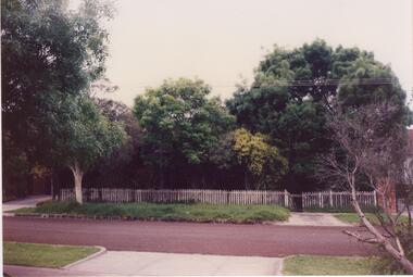
Document - Field Street, 11, Caulfield South
An unattributed, undated, colour photograph (100mm x 150mm) of 11 Field Street, Caulfield South, from the street, showing fence and trees. The file also includes a handwritten list of the owners of 11 Field Street, taken from Sands and McDougall’s Directory of Victoria 1923-1970.caulfield south, field street, jackson herbert, jackson a, jackson beryl -
 Bendigo Military Museum
Photograph - 4th Field Survey Squadron deployed on Operation NERIGHT, Queensland & Northern Territory, 1989
This is a set of 19 photographs taken in 1989 during 4th Field Survey Squadron’s deployment on Operation NERIGHT 89 in Queensland and the Northern Territory. It was a two-part operation in 1989 with work conducted in the areas of Camooweal and Weipa. Part 1 was the field completion of topographic maps conducted near Camooweal QLD, along the Barkley Highway on the border between NT and QLD, from the 12th of September to the 20th of October 1989. A Bell Kiowa LOH helicopter from 162 Recce Sqn supported topographic field completion. Operation NERIGHT 89 Part 2 was the acquisition of mapping control by GPS field parties utilising Texas Instruments TI4100 Global Positioning System receivers around Weipa on Cape York Peninsula from the 22nd of September to the 22nd of October 1989. Part 2 Two Bell UH-1H Iroquois helicopters from RAAF’s 35 Squadron were principally used to deploy GPS field parties. Identification photography of control points was taken by air camera operators in AAAvn Pilatus Porter aircraft from 173 Gen Spt Sqn fitted with an RC10 aerial camera. The two parts of the operation were conducted concurrently. This is a set of 19 photographs taken in 1989 during 4th Field Survey Squadron’s deployment on Operation Neright in Queensland & the Northern Territory. The colour photographs are on 35mm negative film and are part of the Army Survey Regiment’s Collection. The photographs were scanned at 96 dpi. .1) to .3) - Photo, colour, 1989. En-route to areas of survey operations. .4) to .5) - Photo, colour, 1989. Unidentified personnel relax next to river/waterhole. .6) - Photo, colour, 1989. Two Bell UH-1H Iroquois helicopters from RAAF’s 35 SQN utilised in the movement of GPS parties. .7) to .9) - Photo, colour, 1989. Unidentified soldier practices repelling from a UH1H Iroquois helicopter. .10) - Photo, colour, 1989. Inside the cockpit of a UH1H Iroquois helicopter. .11) - Photo, colour, 1989. Field Party camp with GPS equipment in foreground. Unidentified soldier prepares a meal. .12) - Photo, colour, 1989. GPS antenna plumbed over a survey ground mark. Witness post on left. .13) & .14) - Photo, colour, 1989. Unknown Cape York Peninsula beaches. .15) & .16) - Photo, colour, 1989. Dramatic fire next to base camp. .17) - Photo, colour, 1989. Aboriginal rock art at unknown location. .18) - Photo, colour, 1989. Aboriginal rock art at unknown location. L to R: unidentified, SPR Andrew Quin. .19) - Photo, colour, 1989. Aboriginal rock art at unknown location. LT Chris Topovsek..1P to .19P – There are no personnel identified. ‘1989 OP NERIGHT’ annotated on negative sleeve.royal australian survey corps, rasvy, 4 fd svy sqn, op neright 89 -
 Melbourne Tram Museum
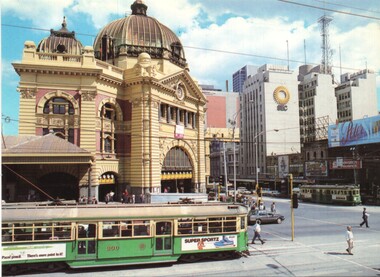
Postcard - Flinders St Station and SW6 900, Colour Tech Productions Pty Ltd, c1970
Produced by Robert Schorn, early 1970's shows two of Melbourne icons - Flinders St station and W class trams. SW6 900 northbound in Swanston Street Has the SEC building in the background, a advert for Peter Stuyvesant (cigarettes). The tram has adverts for Pacer pencils and Super Sportz shoes. There is a W2 class tram in Flinders St. A Policeman is on point duty - bottom right of the photo. Published by Colour Tech Productions of Canberra,Demonstrates two iconic images of Melbourne.Postcard - colour - by Colour Tech Productions of Canberra, divided back - card number CTM 107 RPtrams, tramways, flinders st station, swanston street, sw6 class, tram 900 -
 Federation University Historical Collection
Document, Rough Correspondence concerning the Ballarat School of Mines Science and Field Naturalists Club from Charles Hoadley, 1916, 1915
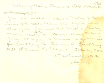
Charles Archibald Hoadley, C.B.E., M.Sc (Melb), B.M.E. (Melb), A.M.I.E., lectured in Surveying, Engineering, Mining and Physics at the Ballarat School of Mines, 1914-16.Rough correspondence of the Ballarat School of Mines Science and Field Naturalists Club.School of Mines Science and Field Naturalists Club. You are invited to attend a meeting of the Ladies of the Science Club together with those of the Technical Art School on Monday evening next Oct. 11 in the Council Room School of Mines at 8. p.m to consider ways and means for furthering the success of forthcoming Wild Flower Exhibition on Saturday Oct 16. C A Hoadley MSc Hon Secballarat school of mines, science and field naturalists club, wild flower show, hoadley -
 National Vietnam Veterans Museum (NVVM)
Photograph, A Field Battery - back from another operation in support of 3RAR
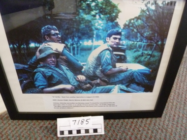
Black framed colour photo of three gunners in the back of a landrover returning from another operation. Rubber plantation and another landrover in the backgroundA Field Battery - back from another operation in support of 3RARa field battery, gnr gordon bright, gnr martin wiseman, bdr john hall -
 University of Melbourne, Burnley Campus Archives
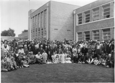
Photograph - Black and white print, Poultry Breeders Field Day, 1953
Note by T.H. Kneen 24 June 1992, "Can identify Mr. Talbot Chief Veterinary Officer Department of Agriculture - bald headed gentleman seated towards right. Second from his right is Mrs. D. Kneen, Principal's wife. The N.U.P.B.A. Field Days were held annually. At that time the Egg-Laying Competition was under the administrative control of the School of Horticulture." .Black and white photograph. Large group of men, women and children gathered on the lawn in front of the Administration Building. Also see B91.269On reverse, "N.U.P.B.A. Field Day Feb 1953." (National Union of Poultry Breeders Association?)men, women, children, lawn, administration building, nupba, field day, 1953, national union of poultry breeders association, mr. talbot, chief veterinary officer, department of agriculture, principal's wife, egg-laying competition, school of horticulture, mrs d kneen -
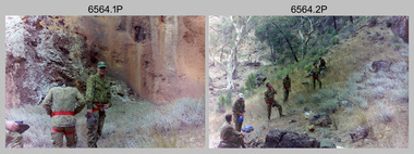
 Bendigo Military Museum
Photograph - 4th Field Survey Squadron – Operation MIZMAZE 92, Kimberley region, Western Australia, 1992
This is a set of 40 photographs taken in 1992 during 4th Field Survey Squadron’s deployment on Operation MIZMAZE 92 in the Kimberley region of Western Australia from the 13th of May to the 14th of July 1992. The area of operations was Wyndham, Halls Creek and Sandfire Flat. It was a two-part operation involving the field completion of topographic maps and the acquisition of mapping control by GPS field parties utilising Texas Instruments TI4100 Global Positioning System receivers. Survey parties conducted field checking of topographic maps and GPS control acquisition in Perentie 110 Series Survey variant FFR Land Rovers. Three Bell Kiowa LOH helicopters provided by 162 Recce Sqn supported field checking and limited deployment of GPS surveys parties. C-l30 Hercules from 36 Sqn supported deployment and extraction of personnel and equipment to and from from the AO. A Cessna 404 Titan Ambassador from Vee-H Aviation was used as the Wild RC10 camera platform for aerial photography acquisition.This is a set of 40 photographs taken in 1992 during 4th Field Survey Squadron’s deployment on Operation MIZMAZE 92 in the Kimberley region of Western Australia. The colour photographs are on 35mm negative film and are part of the Army Survey Regiment’s Collection. The photographs were scanned at 96 dpi. .1) - Photo, colour, 1992. CAPT Craig Hersant. .2) - Photo, colour, 1992. Unidentified officer/soldier. .3) & .4) - Photo, colour, 1992. Aboriginal rock art - Wandjina Gunduran, Donkey Creek. .5) - Photo, colour, 1992. Aboriginal rock art - Track Wandjinas, Donkey Creek. .6) & .7) - Photo, colour, 1992. CAPT Craig Hersant. .8) - Photo, colour, 1992. Kimberley region topography. CPL Glen Weatherell. .9) - Photo, colour, 1992. Unidentified personnel .10) - Photo, colour, 1992. Supermarket at unknown location. .11) to .13) - Photo, colour, 1992. Caravan park at unknown location. .14) - Photo, colour, 1992. Old bridge at Fitzroy Crosssing. .15) & .16) - Photo, colour, 1992. Survey party in Perentie 110 Series Land Rover. .17) & .18) - Photo, colour, 1992. Kimberley region topography. .19) - Photo, colour, 1992. Kimberley region topography. CPL Glen Weatherell. .20) - Photo, colour, 1992. Kimberley region topography, possibly the Bungle Bungles. .21) - Photo, colour, 1992. Kimberley region topography. SGT Frank Downie. .22) - Photo, colour, 1992. Kimberley region topography: the Bungle Bungles. .23) - Photo, colour, 1992. Kimberley region topography: the Bungle Bungles. .24) - Photo, colour, 1992. Kimberley region topography: the Bungle Bungles. SPR Neil Pedler. .25) & .26) - Photo, colour, 1992. Kimberley region topography: the Bungle Bungles. .27) - Photo, colour, 1992. Kimberley region topography. .28) - Photo, colour, 1992. Survey party with Perentie 110 Series Land Rover. .29) - Photo, colour, 1992. Kimberley region topography. .30) - Photo, colour, 1992. Survey party outside Perentie 110 Series Land Rover. .31) & .32) - Photo, colour, 1992. Survey party operating TI4100 GPS Receiver next to Perentie 110 Series Land Rover. SGT Eddie Jacobs. .33) & .34) - Photo, colour, 1992. Survey party operating TI4100 GPS Receiver next to Perentie 110 Series Land Rover. Unidentified surveyor. .35) - Photo, colour, 1992. Kimberley region topography. Hand water pump at well. .36) - Photo, colour, 1992. Survey party in Perentie 110 Series Land Rover. .37) - Photo, colour, 1992. Kimberley region topography. CPL Glen Weatherell. .38) - Photo, colour, 1992. Kimberley region topography viewed from Bell Kiowa LOH helicopter. .39) & .40) - Photo, colour, 1992. Unidentified surveyor field checking a preliminary map in a Bell Kiowa LOH helicopter..1P to .40P – There are no personnel identified. ‘1992 OP MIZMAZE annotated on negative sleeve.royal australian survey corps, rasvy, 4 fd svy sqn, op mizmaze 92 -
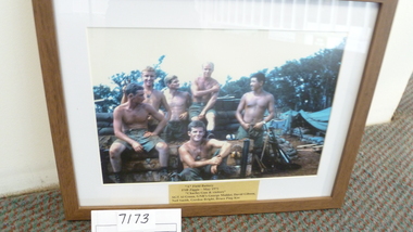
 National Vietnam Veterans Museum (NVVM)
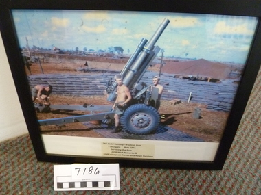
Photograph, A Field Battery - Foxtrot Gun - FSB Ziggie
Black framed colour photo of three gunners servicing the gun at FSB Ziggie May. 1971A Field Battery - Foxtrot Gun - FSB Ziggie May 1971 - Servicing the guna field battery, foxtrot gun, lbdr mick richards, gnr stephen turner, gnr ralph harrison -
 National Vietnam Veterans Museum (NVVM)
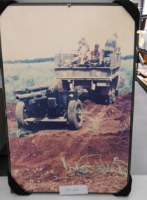
Photograph, Towing Field Artillery
Mounted colour Photograph of a truck with diggers on board towing an Artillery piece through a field43 on back of truckphotograph, field artillery -
 Victorian Aboriginal Corporation for Languages
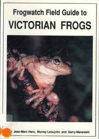
Book, Jean-Marc Hero et al, Frogwatch field guide to Victorian frogs, 1991
Detailed book on frogs in Victoria giving very clear descriptions.Maps, colour illustrations, colour photographsfrogs, habitats, toads, tree frogs, tadpoles -
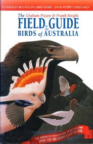 Victorian Aboriginal Corporation for Languages
Book, Graham Pizzey et al, The Graham Pizzey &? Frank Knight field guide to the birds of Australia, 1999
Detailed descriptions of Australian native birds at all life stages, including their calls and range of habitat.Maps, colour illustrations, colour photographsbirds, australia, identification -
 National Vietnam Veterans Museum (NVVM)
Photograph, A Field Battery FSB Ziggie - May 1971 "Charles gun and visitors"
Plastic fawn coloured wood grain framed colour photo of six soldiers relaxing on ammo boxes and sand bags in gun pitA Field Battery FSB Ziggie May 1971 "Charles Gun and Visitors"a field battery, fsb ziggie, sgt al green, gnr george mulder, gnr david gibson, gnr neil smith, gnr gordon bright, gnr bruce ping kee -
 Bendigo Military Museum
Photograph - 4th Field Survey Squadron – Operation ARIGHT 91, Queensland, 1991
This is a set of 16 photographs taken during 4th Field Survey Squadron’s deployment on Operation ARIGHT 91 in Queensland from the 8th of July to the 5th of September 1991. The area of operations was the top end of the Cape York Peninsula, islands of the Torres Strait and the southern coast of PNG. Field parties utilised Texas Instruments TI4100 Global Positioning System receivers. Concurrent with GPS operations Doppler point positioning observations were carried out by field parties using Magnavox MX 1502 receivers on six of the control points. Two Bell UH-1H Iroquois helicopters from RAAF’s 171 COMD and Liaison Squadron were primarily used to deploy GPS field parties. Identification photography of control points was taken by air camera operators in AAAvn Pilatus Porter aircraft from 173 Gen Spt Sqn fitted with an RC10 aerial camera.This is a set of 16 photographs taken in 1991 during 4th Field Survey Squadron’s deployment on Operation ARIGHT in Queensland. The colour photographs are on 35mm negative film and are part of the Army Survey Regiment’s Collection. The photographs were scanned at 96 dpi. .1) to .3) - Photo, colour, 1991. Area of Operations (AO) coordination maps. .4) - Photo, colour, 1991. GPS acquisition post-processing. L to R: LT Simon Buckpitt, SSGT Steve Winner, WO2 Ken Talbot-Smith. .5) to .6) - Photo, colour, 1991. Base camp unidentified personnel. .7) - Photo, colour, 1991. L to R: OPS WO - WO2 Ken Talbot-Smith, DET SSM WO1 Stevo Hinic. .8) - Photo, colour, 1991. Base camp unidentified personnel. .9) - Photo, colour, 1991. Base camp L to R: unidentified (x2), OPS WO - WO2 Ken Talbot-Smith. .10) - Photo, colour, 1991. Base camp unidentified soldier. .11) - Photo, colour, 1991. Base camp L to R: CPL Andy Love, unidentified, SGT Steve McGuiness. .12) - Photo, colour, 1991. Base camp at Horn Island Army Compound. .13 to .16) - Photo, colour, 1991. Unknown locations in Area of Operations..1P to .16P – There are no personnel identified. ‘1991 OP ARIGHT’ annotated on negative sleeve.royal australian survey corps, rasvy, 4 fd svy sqn, op aright 91 -
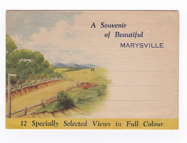
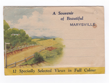 Marysville & District Historical Society
Postcard (item) - Colour photographs, Nucolorvue Productions, A Souvenir of Beautiful Marysville-12 Specially Selected Views in Full Colour, 1950's
An envelope of 12 colour photographs of attractions in and around Marysville in Victoria.An envelope of 12 colour photographs of attractions in and around Marysville in Victoria. These photographs were produced by Nucolorvue Productions in Mentone, Victoria.A Souvenir of Beautiful MARYSVILLE 12 Specially Selected Views in Full Colour Marysville, Victoria, Australia Marysville, 60 miles from Melbourne, is one of nature's/ lovely beauty spots. The invigorating mountain air helps the/ visitor to enjoy the many delightful walks amongst the tall/ timber, or through the fern glades. Apart from many excellent walking trips, Marysville district/ offers ample scope for car trips to the nearby Cumberland Forest,/ Buxton, Narbethong, or the Taggerty Valley. Skiers find Lake Mountain an attraction in the winter, whilst/ the hiker finds ample for his needs in the numerous mountain/ areas. Huge Eucalypt trees, revealing their ramrod straightness up/ to 300 feet in height, are a fitting background to the many/ beautiful creeks and waterfalls. PUBLISHED BY NUCOLORVUE PRODUCTIONS, MENTONE, VICTORIA.nicholl's lookout (image 1), eildon weir (image 2), road to lake mountain (image 3), foot of steavenson falls (image 4), steavenson falls (image 5), bush scene near marysville (image 6), bush track marysville (image 7), bridge and chalet and crossways marysville (image 8), log cabin at marysville (image 9), black spur (image 10), taggerty river (image 11), highest known hardwood tree (image 12), marysville, victoria, nucolorvue productions, postcard, souvenir -
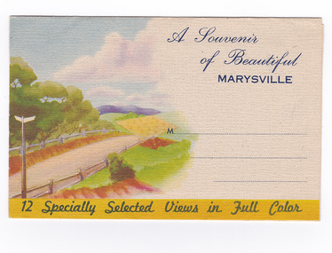
 Marysville & District Historical Society
Postcard (item) - Colour photographs, Nucolorvue Productions, A Souvenir of Beautiful Marysville-12 Specially Selected Views in Full Colour, Unknown
An envelope of 12 colour photographs of attractions in and around Marysville in Victoria.An envelope of 12 colour photographs of attractions in and around Marysville in Victoria. These photographs were produced by Nucolorvue Productions in Mentone, Victoria.A Souvenir of Beautiful MARYSVILLE 12 Specially Selected Views in Full Colour Marysville, Victoria, Australia Marysville, 60 miles from Melbourne, is one of nature's/ lovely beauty spots. The invigorating mountain air helps the/ visitor to enjoy the many delightful walks amongst the tall/ timber, or through the fern glades. Apart from many excellent walking trips, Marysville district/ offers ample scope for car trips to the nearby Cumberland Forest,/ Buxton, Narbethong, or the Taggerty Valley. Skiers find Lake Mountain an attraction in the winter, whilst/ the hiker finds ample for his needs in the numerous mountain/ areas. Huge Eucalypt trees, revealing their ramrod straightness up/ to 300 feet in height, are a fitting background to the many/ beautiful creeks and waterfalls. PUBLISHED BY NUCOLORVUE PRODUCTIONS, MENTONE, VICTORIA.nicholl's lookout (image 1), eildon weir (image 2), road to lake mountain (image 3), foot of steavenson falls (image 4), steavenson falls (image 5), bush scene near marysville (image 6), bush track marysville (image 7), bridge and chalet and crossways marysville (image 8), log cabin at marysville (image 9), black spur (image 10), taggerty river (image 11), highest known hardwood tree (image 12), marysville, victoria, nucolorvue productions, postcard, souvenir -
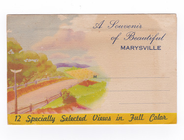
 Marysville & District Historical Society
Postcard (item) - Colour photographs, Nucolorvue Productions, A Souvenir of Beautiful Marysville-12 Specially Selected Views in Full Colour, Unknown
An envelope of 12 colour photographs of attractions in and around Marysville in Victoria.An envelope of 12 colour photographs of attractions in and around Marysville in Victoria. These photographs were produced by Nucolorvue Productions in Mentone, Victoria.A Souvenir of Beautiful MARYSVILLE 12 Specially Selected Views in Full Colour Marysville, Victoria, Australia Marysville, 60 miles from Melbourne, is one of nature's/ lovely beauty spots. The invigorating mountain air helps the/ visitor to enjoy the many delightful walks amongst the tall/ timber, or through the fern glades. Apart from many excellent walking trips, Marysville district/ offers ample scope for car trips to the nearby Cumberland Forest,/ Buxton, Narbethong, or the Taggerty Valley. Skiers find Lake Mountain an attraction in the winter, whilst/ the hiker finds ample for his needs in the numerous mountain/ areas. Huge Eucalypt trees, revealing their ramrod straightness up/ to 300 feet in height, are a fitting background to the many/ beautiful creeks and waterfalls. PUBLISHED BY NUCOLORVUE PRODUCTIONS, MENTONE, VICTORIA.nicholl's lookout (image 1), eildon weir (image 2), road to lake mountain (image 3), foot of steavenson falls (image 4), steavenson falls (image 5), bush scene near marysville (image 6), bush track marysville (image 7), bridge and chalet and crossways marysville (image 8), log cabin at marysville (image 9), black spur (image 10), taggerty river (image 11), highest known hardwood tree (image 12), marysville, victoria, nucolorvue productions, postcard, souvenir -
 Bendigo Military Museum
Photograph - 4th Field Survey Squadron Regimental Training - Exercise ‘Fuggy Hollow’ in SA, 1994
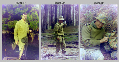
This is a set of 30 photographs of 4th Field Survey Squadron personnel undergoing regimental training in 1994, at Second Valley Conservation Park in South Australia. The aim of Exercise ‘Fuggy Hollow’ was typically to provide personnel a practical knowledge of infantry and minor tactics (IMT) at the section level, navigation and map reading, RATEL and survival in the Field.This is a set of 30 photographs of 4th Field Survey Squadron personnel undergoing regimental training in 1994, at Second Valley Conservation Park in South Australia. The colour photographs are on 35mm negative film and are part of the Army Survey Regiment’s Collection. The photographs were scanned at 96 dpi. .1) - Photo, colour, 1994. Unidentified soldier. .2) - Photo, colour, 1994. CPL Phuc ‘Charlie’ Tran. .3 to .5) - Photo, colour, 1994. CAPT Chris Topovsek. .6) & .7) - Photo, colour, 1994. Unidentified soldiers. .8) - Photo, colour, 1994. L to R: SPR Fran Calvert, unidentified (x2), SPR Mark Linford, unidentified. .9) to .17) - Photo, colour, 1994. Unidentified soldiers. .18) & .19) - Photo, colour, 1994. L to R: LT Andrew Caudle, SSGT Brian Collings, OC Maj Peter Demaine. .20) - Photo, colour, 1994. WO2 Peter Hammer. .21) - Photo, colour, 1994. L to R: CAPT Chris Topovsek, SSGT Brian Collings, WO2 Peter Hammer .22) - Photo, colour, 1994. SSGT Brian Collings. .23) - Photo, colour, 1994. L to R: unidentified, SPR Fran Calvert. .24) - Photo, colour, 1994. L to R: SPR Mark Sinderberry, SGT Steve McGuiness, unidentified. .25) - Photo, colour, 1994. SPR Mark Linford. .26) - Photo, colour, 1994. L to R: unidentified (x2), SPR Fran Calvert, unidentified. .27 & .28) - Photo, colour, 1994. L to R: SSGT Brian Collings, WO2 Peter Hammer. .29) - Photo, colour, 1994. WO2 Simon ‘Andy’ Capp. .30) - Photo, colour, 1994. SGT H. Evertz..1P to .30P – There are no personnel identified. ‘1994 EX FUGGY HOLLOW (IMTs) Second Valley Conservation Park’ annotated on negatives sleeve.royal australian survey corps, rasvy, 4 fd svy sqn -
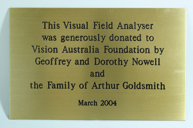 Vision Australia
Photograph - Image, Visual Field Analyser donation, 2004
Visual field analysers are used by eye specialists to determine the type and extent of visual defect, through the eye of light. To fund some pieces of equipment, funds were raised from donors who were then acknowledged through the attachment of a plaque.Gold coloured metal plate with black writingThis Visual Field Analyser was generous donated to Vision Australia Foundation by Geoffrey and Dorothy Newell and the Family of Arthur Goldsmith March 2004geoffrey nowell, dorothy nowell, arthur goldsmith, vision australia foundation -
 Bendigo Military Museum
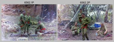
Photograph - 4th Field Survey Squadron Adventurous Training, Unknown Location, SA, 1994
This is a set of 28 photographs of 4th Field Survey Squadron undergoing adventurous training held at unknown locations in South Australia, in 1994. It is also possible the training was in the Grampians region of Victoria. Off-road driver training and abseiling were key activities of this adventurous training as well as teamwork, leadership, and field craft. Elements from units of the Army Reserve may have participated in the training. See items 6561.31P, 6562.33P and 6563.33P for more photos taken during this training activity.This is a set of 28 photographs of 4th Field Survey Squadron personnel undergoing adventurous training held at unknown locations in South Australia in 1994. The colour photographs are on 35mm negative film and are part of the Army Survey Regiment’s Collection. The photographs were scanned at 96 dpi. .1) - Photo, colour, 1994. Abseiling. Unidentified personnel. .2) - Photo, colour, 1994. Abseiling. L to R: Unidentified (x2), WO2 Ken Talbot-Smith, unidentified, SGT Mark Donnelly, unidentified. .3) to .10) - Photo, colour, 1994. Training area terrain. .11) to .12) - Photo, colour, 1994. Abseiling. Unidentified personnel. .13) to .14) - Photo, colour, 1994. Training area terrain. .15) - Photo, colour, 1994. Training area terrain. L to R: SSGT Brian ‘BC’ Collings, unidentified (x6). .16) - Photo, colour, 1994. Training area terrain. .17) - Photo, colour, 1994. Training area terrain. Unidentified personnel. .18) - Photo, colour, 1994. Training area terrain. L to R: SSGT Brian ‘BC’ Collings, SGT Steve McGuiness. .19) - Photo, colour, 1994. Training area terrain. .20) to .27) - Photo, colour, 1994. Abseiling. Unidentified soldiers. .28) - Photo, colour, 1994. Returning to 4 Fd Svy Sqn. L to R: SPR Fran Calvert, unidentified, SPR Gordon Santo, SPR Matt Arnold, SGT Dave Cook..1P to .28P – There are no personnel identified. ‘1994 ADV TRAINING’ annotated on negatives sleeve.royal australian survey corps, rasvy, 4 fd svy sqn -
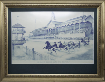 Victorian Harness Racing Heritage Collection at Lord's Raceway Bendigo
Print - Framed print, A Fair Field and No Favor
The original lithograph by American artist John Cameron was published by Currier & Ives around 1891.Large monochrome print in guild framed reproduction of John Cameron artwork depicting a harness racing finish in America.A Fair Field and No Favorgraydon, trotting, historic print, america, john cameron -
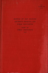 National Vietnam Veterans Museum (NVVM)
Booklet, British Army, Manual of Map Reading, Air Photo Reading And Field Sketching. Part 3, Field Sketching, 1957, 1957
A red coloured cover with black writing on the front. In the middle reads Manual of Map Reading, Air Photo Reading And Field Sketching. Part 3, Field Sketching, 1957. Top Right corner reads WO Code No. 9085.british armed forces - service manuals, ministry of defence (army) -
 Bendigo Military Museum
Photograph - 4th Field Survey Squadron – Operation ARIGHT 93, Queensland, 1993
This is a set of 42 photographs taken during 4th Field Survey Squadron’s deployment on Operation ARIGHT 93 in North Queensland from the 30th of August to the 8th of October 1993. The Survey Field Completion area of operations was Weipa near the top end of the Cape York Peninsula. Survey parties conducted field checking of topographic maps covering Bamaga, Heathlands, Weipa, Lockhart River and Strathgordon in Perentie 110 Series Survey variant FFR Land Rovers. Hand-held Trimble and Magellan GPS receivers were used to assist with navigation and to position remote isolated features. Three Bell Kiowa LOH helicopters provided by 162 Recce Sqn supported field checking operations. Supplementary and Vital Asset Protection photography was taken by air camera operators in AAAvn Nomad aircraft from 173 Survl Sqn fitted with an RC10 aerial camera.This is a set of 42 photographs taken in 1993 durin8g 4th Field Survey Squadron’s deployment on Operation ARIGHT in North Queensland. The colour photographs are on 35mm negative film and are part of the Army Survey Regiment’s Collection. The photographs were scanned at 96 dpi. .1) - Photo, colour, 1993. Survey party in Perentie 110 Series Land Rover navigates through Cape York Peninsula sand hills. .2) - Photo, colour, 1993. Cape York Peninsula sand hills. .3) - Photo, colour, 1993. Cape York Peninsula Island. .4) - Photo, colour, 1993. Survey party in Perentie 110 Series Land Rover enters a Cape York Peninsula beach. .5) - Photo, colour, 1993. SPR Kim Baker takes a break on a Cape York Peninsula beach. .6) - Photo, colour, 1993. L to R: MAJ Andy Cordova (USA Exchange) from the Army Survey Regiment and unidentified civilians. .7) to .14) - Photo, colour, 1993. Cape York Peninsula topography. .15) - Photo, colour, 1993. Unidentified surveyor in Bell Kiowa LOH helicopter. .16) - Photo, colour, 1993. Bell Kiowa LOH helicopter circles base camp. .17) to .18) - Photo, colour, 1993. Cape York Peninsula topography. .19) - Photo, colour, 1993. Vehicle convoy taking a break. L to R: LT John Bath (Detachment OC), unidentified (x2), SPR Chris Pearse. .20) - Photo, colour, 1993. Vehicle convoy taking a break. .21) - Photo, colour, 1993. Vehicle convoy ready to go. SPR Chris Pearse. .22) - Photo, colour, 1993. Vehicle convoy on the move. .23) - Photo, colour, 1993. Cape York Peninsula topography. .24) - Photo, colour, 1993. Unidentified personnel. .25) - Photo, colour, 1993. SGT Neale ‘Tex’ Houston. .26) - Photo, colour, 1993. Ground below a Bell Kiowa LOH helicopter .27) - Photo, colour, 1993. L to R: SPR Mark Sinderberry and CPL Stuart Adrain in a Bell Kiowa LOH helicopter. .28) & .29) - Photo, colour, 1993. Ground below a Bell Kiowa LOH helicopter. .30) - Photo, colour, 1993. Base camp viewed from a Bell Kiowa LOH helicopter. .31) - Photo, colour, 1993. Cape York Peninsula topography in recovery after burn-off. .32) & .33) - Photo, colour, 1993. SPR Kim Baker contemplates crossing this bridge in his Land Rover. .34) - Photo, colour, 1993. SPR Kim Baker takes a break next to a billabong. .35) - Photo, colour, 1993. Survey party in Perentie 110 Series Land Rover crosses a creek. .36) - Photo, colour, 1993. Cape York Peninsula bush fire in distance. .37) - Photo, colour, 1993. Survey party in Perentie 110 Series Land Rover traverses a sand hill. .38) - Photo, colour, 1993. SPR Kim Baker. .39) - Photo, colour, 1993. Cape York Peninsula bush fire. .40) - Photo, colour, 1993. Cape York Peninsula topography. .41) & .42) - Photo, colour, 1993. Cape York Peninsula sand hills..1P to .42P – There are no personnel identified. ‘1993 OP ARIGHT’ annotated on negative sleeve.royal australian survey corps, rasvy, 4 fd svy sqn, op aright 93 -
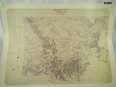 Bendigo Military Museum
Map - Australian Topographical Survey SYDNEY / 56III Southern Half, NE Plane Table Field sheet 1915, Australian Survey Corps, 6 Dec 1915
This is a unique example of a hand drawn plane table sheet produced in the first year of the Australian Survey Corps by original members of the Corps. Roseblade and Lynch 5 Dec 1915. Of interest is the documented times that it took to create the original field sheet. Also of interest is the fact that this field sheet that was used to create the actual SYDNEY map sheet was contoured, many map sheets produced up until now were purely planimetric and lacked contouring that was needed for military use. This is a reproduction print of a photograph of the original field sheet and was printed at the Army Survey Regiment, Bendigo.Reprinted coloured Image of Australian Topographical Survey SYDNEY /56 III Southern Half, hand drawn NE Plane Table field sheet. Includes an itemized summary of work performed by HA Roseblade CSM Australian Survey Corps 1915, Signed by J Lynch Lieutenant.royal australian survey corps, rasvy, fortuna, army survey regiment, army svy regt, asr -
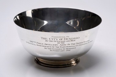 City of Greater Bendigo - Civic Collection
Decorative object - Corporate Gift :: Silver Bowl, 150th Field Artillery Army of the United States, 1942
Sterling Circa 1768 Paul Revere Reproduction Bowl manufactured by Shreve Crump & Low Co. Currently there is no information about the 150th Field Artillery visit to Bendigo in 1942 although Defence manufacturing in Bendigo has a long history with Thales continuing to produce machinery and vehicles on the original site of the Ordnance Factory which began operating in 1943.Large engraved silver bowl. Presented to / The City of Bendigo / By the Officers and Men / of the / 150th Field Artillery Army of the United States / In Grateful Remembrance of the Warm Hospitality extended to them / By the Citizens of Bendigo / In February 1942 Underside; Shreve, Crump & Low and Co/ sterling / 809 by / P. Revere / Boston 1768 / Sons of Liberty / reproductioncity of bendigo commerce -
 Bendigo Military Museum
Photograph - 4th Field Survey Squadron Adventurous Training, Unknown Location, SA, 1994
This is a set of 33 photographs of 4th Field Survey Squadron undergoing adventurous training held at unknown locations in South Australia, in 1994. It is also possible the training was in the Grampians region of Victoria. Off-road driver training and abseiling were key activities of this adventurous training as well as teamwork, leadership, and field craft. Elements from units of the Army Reserve may have participated in the training. See items 6561.31P, 6562.33P and 6564.28P for more photos taken during this training activity.This is a set of 33 photographs of 4th Field Survey Squadron personnel undergoing adventurous training held at unknown locations in South Australia in 1994. The colour photographs are on 35mm negative film and are part of the Army Survey Regiment’s Collection. The photographs were scanned at 96 dpi. .1) - Photo, colour, 1994. Preparation. LCPL Mitch Oake. .2) - Photo, colour, 1994. Preparation. SPR Chris Pearse. .3) & .4) - Photo, colour, 1994. Preparation. Unidentified soldier. .5) - Photo, colour, 1994. Preparation. SSGT Pat ‘Fuji’ Drover. .6) - Photo, colour, 1994. Preparation. L to R: SGT Steve McGuiness, CPL Steve Wegener, CPL Dick Crawford, CPL Peter Ball, SPR Greg Richards. .7) - Photo, colour, 1994. Preparation. L to R: CPL Peter Ball, SPR Greg Richards. .8) to .10) - Photo, colour, 1994. Preparation. SSGT Lynn Johnson. .11) - Photo, colour, 1994. Social activities. L to R: Unidentified (x8), SPR Chris Pearse, SSGT Lynn Johnson. .12) - Photo, colour, 1994. Social activities. SGT Dave Longbottom. .13) to .15) - Photo, colour, 1994. Social activities. Unidentified personnel. .16) - Photo, colour, 1994. Social activities. L to R: SGT Dave Cook, WO2 Simon ‘Andy’ Capp, CAPT Rob Gray, SPR Chris Pearse, SPR Mark McInerney. .17) to .19) - Photo, colour, 1994. Training area terrain. .20) to .23) - Photo, colour, 1994. Driver training. .24) - Photo, colour, 1994. Training area terrain. .25) - Photo, colour, 1994. Abseiling. SSGT Pat ‘Fuji’ Drover. .26) - Photo, colour, 1994. Abseiling. SGT Mark Donnelly. .27) to .33)- Photo, colour, 1994. Abseiling. Unidentified soldier. .1P to .33P – There are no personnel identified. ‘1994 ADV TRAINING’ annotated on negatives sleeve.royal australian survey corps, rasvy, 4 fd svy sqn -
 Federation University Historical Collection
Book, Minute Book of the Ballarat School of Mines Science and Field Naturalists Club, 1915-1918, 8 May 1915 - October 1918
This minute book records the reformed Science and Field Naturalists Club of the Ballarat School of Mines. Such a club had existed in 1888 and 1889. Final recorded meeting took place on 17th November 1918, resolved that "there would be no further meeting of the Club until further notice was given." (Ballarat School of Mines Annual Report of 1888, p.17. Also mentioned in Annual Report 1889, p.195)Dark blue hard-cover minute book with dark red spine. 186 numbered lined pages with left hand margin. Last entry on p.128. Courier Newspaper article 'Victorian National Park: Our Fauna and Fauna' by Charles Hoadley published 16/06/1915 Included: State Savings Bank of Victoria account booklet No. 128.155, issued to School of Mines Science and Field Naturalists Club.ballarat school of mines, smb, science and field naturalists club, fenner, charles fenner, albert w. steane, william baragwanath, john brittain, lal lal, lal lal excursion, science nad field naturalists club, ballarat field naturalists wild flower show, maurice copland, alfred mica smith, sunnyside woollen mill excursion, wilson's promontory, charles hoadley -
 Glenelg Shire Council Cultural Collection
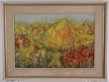
Painting, Isabel Huntington, Poppies in Flanders Field, 1968
CEMA Art Collection Winner of 1968 Portland Art Society Prize for the category of other media.The painting is depiction of a field which is predominantly yellow with patches of red. The largest red patches are in the lower right corner and centre left side. Another focus point of the work is a large yellow mound slightly off centre which may represent a haystack. The background is a light blue sky. The work has a painted wooden frame with material mount and glass covering only the paint surface.Front: Huntington (signature, lower left) Back: ISABEL HUNTINGTON "POPPIES IN FLANDERS FIELD" (1968) (typed label) Yellow Sticker: 1968-cema, portland artists society, wwi, female artist, world war i, the great war -
 Rutherglen Historical Society
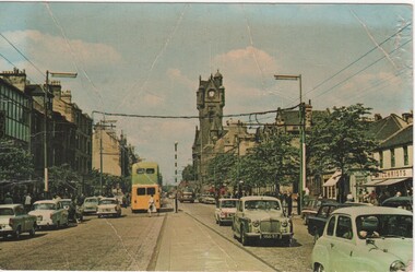
Image, c1950
Postcard sized photograph of Main Street, Rutherglen ScotlandOn back of photo: "SDS 154 Town Hall & Main Street, Rutherglen (from the East). Colour by John C. Miller"rutherglen scotland, main street rutherglen scotland -
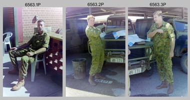
 Bendigo Military Museum
Photograph - 4th Field Survey Squadron Adventurous Training, Unknown Location, SA, 1994
This is a set of 33 photographs of 4th Field Survey Squadron undergoing adventurous training held at unknown locations in South Australia, in 1994. It is also possible the training was in the Grampians region of Victoria. Off-road driver training and abseiling were key activities of this adventurous training as well as teamwork, leadership, and field craft. Elements from units of the Army Reserve may have participated in the training. See items 6561.31P, 6563.33P and 6564.28P for more photos taken during this training activity.This is a set of 33 photographs of 4th Field Survey Squadron personnel undergoing adventurous training held at unknown locations in South Australia in 1994. The colour photographs are on 35mm negative film and are part of the Army Survey Regiment’s Collection. The photographs were scanned at 96 dpi. .1) - Photo, colour, 1994. Abseiling. L to R: SGT Steve McGuiness, SPR Chris Pearse, SPR Mark McInerney. .2) - Photo, colour, 1994. Abseiling. L to R: CAPT Rob Gray, SSGT Lynn Johnson, CPL Stuart Adrain, unidentified. .3) - Photo, colour, 1994. Abseiling. Top of cliff. .4) - Photo, colour, 1994. Abseiling. L to R: Mark Linwood, unidentified. .5) - Photo, colour, 1994. Abseiling. Unidentified soldier. .6) - Photo, colour, 1994. Abseiling. Unidentified, WO2 Simon ‘Andy’ Capp. .7) & .8) - Photo, colour, 1994. Abseiling. CPL Steve Wegener. .9) & .10) - Photo, colour, 1994. Abseiling. L to R: SPR Greg Richards, unidentified. .11) - Photo, colour, 1994. Abseiling. SPR Chris Pearse, unidentified (x2). .12) & .13) - Photo, colour, 1994. Abseiling. SPR Mark McInerney. .14) - Photo, colour, 1994. Abseiling. Unidentified personnel. .15) - Photo, colour, 1994. Abseiling. SPR Marc Zehntner. .16) - Photo, colour, 1994. Abseiling. SPR Mark McInerney, unidentified. .17) & .18) - Photo, colour, 1994. Abseiling. CAPT Rob Gray. .19) - Photo, colour, 1994. Abseiling. SGT Steve McGuiness. .20) - Photo, colour, 1994. Abseiling. CPL Steve Wegener. .21) - Photo, colour, 1994. Abseiling. L to R: SPR Greg Richards, unidentified. .22) - Photo, colour, 1994. Abseiling. SPR Greg Richards. .23) to .25) - Photo, colour, 1994. Abseiling. SPR Mark Linwood. .26) - Photo, colour, 1994. Abseiling. L to R: CPL Steve Wegener, CAPT Rob Gray, unidentified. .27) & .28) - Photo, colour, 1994. Abseiling. SSGT Lynn Johnson. .29) - Photo, colour, 1994. Abseiling. SGT Steve McGuiness. .30) - Photo, colour, 1994. Abseiling. Unidentified soldier. .31) - Photo, colour, 1994. Abseiling. SPR Mark McInerney. .32) - Photo, colour, 1994. Abseiling. CAPT Rob Gray. .33) - Photo, colour, 1994. Abseiling. Unidentified soldier..1P to .33P – There are no personnel identified. ‘1994 ADV TRAINING’ annotated on negatives sleeve.royal australian survey corps, rasvy, 4 fd svy sqn