Showing 67 items
matching county of grant
-
 Melton City Libraries
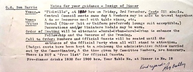
Document, Design of Dinner, c.1970
... in the Captains utility. 1956- 16th March Licence granted... March Licence granted to the County Fire Authority Melton ...Melton Fire Brigade history In a letter to George Minns of 24th March 1942 from the Forests Commission the brigade was registered Class ‘F’ with the certificate of Registration N. 425. In December 1935 a public meeting was held with the purpose of forming a bush fire brigade. Constable Roy Corbett was elected Captain a position he held until 1941 and 1945 –1949. 1942 EW Barrie. 1st Lieut 2nd Lieut TL Barrie 1943 EW Barrie 2nd Lieut 1944 : : MELTON RURAL FIRE BRIGADE Established under CFA act 1944 1945- 1953 EW Barrie Apparatus Officer 1951- 1965 EW Barrie Captain 1967- 1979 EW Barrie elected Group Communication Officer of the Mt Cotterill Fire Brigades. RADIO In 1954 the Fire Brigade introduced 2 HF (high frequency) radios, one was installed in the Fire truck and the other in the Captains utility. 1956- 16th March Licence granted to the County Fire Authority Melton to establish a MOBILE transmitting and receiving station. Area of operation, Melton and District on the frequency (kc/s) 3836 for the exchange of messages relating to the fighting and prevention of fires during actual fires or periods of fire hazard with the CFA Bacchus Marsh base station VL3OX. 1958- 22nd May Commonwealth of Australia, Postmaster-General’s Department Special Licence No H 702 under the Wireless Telegraphy Act 1905-1950 is hereby transferred to Mr. E.W. Barrie, Captain, Melton Rural Fire Brigade to establish a MOBILE transmitting and receiving station. Call sign VL3 OX 6 and VL 3OX 7Group officer Bon Barrie's invitation to a Fire Brigade formal dinner emergency services -
 Whitehorse Historical Society Inc.
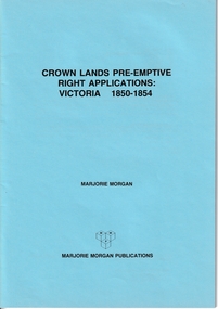
Administrative record - Crown Land Valuations and Applications, Government Printer - John FERRES, Crown Lands Pre-emptive Right Applications: Victoria 1850-1854, 1855
Contains a valuation for Crown Lands applications under pre-emptive right by Victorian county, giving names of applicants name of run, area, and remarks.Contains a valuation for Crown Lands applications under pre-emptive right by Victorian county, giving names of applicants name of run, area, and remarks. Contains a valuation for Crown Lands applications under pre-emptive right by Victorian county, giving names of applicants name of run, area, and remarks. clarke andrew, anglesey, evelyn, bourke, dalhousie, dundas, follett, grant, hampden, heytesbury, normanby, polwarth, ripon, talbot, villiers, district of murray, district of wimmera, district of western port, early settlement, mornington -
 Ringwood and District Historical Society
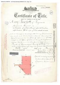
Document, Certificate of Title - Mary Burchett, Lilydale Road, Ringwood - part of Crown Section 20, Parish of Warrandyte, County of Evelyn - 5th July, 1911
A4 copies of Landata Victoria Historical Search documents - Vol 3520 Fol 703990.Mary Burchett of Ringwood, Married Woman, is now the proprietor of an Estate in Fee-simple subject to the Encumbrances notified hereunder ... 50 acres 1 rood 32 perches or thereabouts, being lots 1 and 10 on plan of subdivision no.4315. Subdivision map includes un-named roads - western side is Wonga Road (later Warranwood Road), and eastern side is Grandview Grove (later Bemboka Road), both north of Plymouth Road, Ringwood, Vic. Title transferred to Theodore Hartley Burchett, 27th July, 1911. Encumbrance comment "Special railway condition contained in Grant to Francis Cooke." -
 Eltham District Historical Society Inc
Document - Map, Victoria. Department of Crown Lands and Survey, Town of Eltham, Parish of Nillumbik, County of Evelyn, 2 October 1929
Township of Eltham, Parish of Nillumbik, County of Evelyn / lithographed at the Department of Lands & Survey Melbourne 5th June 1888, amended 2 October 1929 This amendment from the 1888 original shows the reserve for the the State School marked as permanent with dimensions added to Main Road and block frontages along Main Road between Mount Pleasant Road and Dalton Street and Metery Road Possibly photocopied from a copy held at PROV by Harry Gilham whilst resaerching Eltham Primary School history in 1995.a. armstrong, a. lavard, arthur c. allan, arthur c. allen, b. bowatere, baxter street, benjamin oliver wallis, bolton steet, c. souter, c.s. hain, cemetery reserve, charles brown, charles newman, charles symons wingrove, christopher caldwell, church of england, d. anderson, dalton street, david ballard, e. james, e.m. peck, edward dumaresq, eltham town, ely street, f.e. falkiner, f.m. peck, falkiner street, flint street, g. buckingham, g. drabble, george stebbing, godalmin street, h. peck, h.c.whess, h.h. farquharson, h.j. bews, henry stooke, j. goer, j. mcdonald, j. mclaren, j. roberts, j.b. knagers, james irish, jane bailey (nee matthews), john l. smith, john mason, john scott, john smith, joseph stevenson, joseph verse, k. wingrove, k.e. dunstan, kerby street, kirby street, location tbd, m. coman, map, michael o'shea, o.b. mccutcheon, p. & g. tumbull, p.k. mccaughan, p.p. cotter, porter street, pound reserve, robert hepburn, roman catholic church, s. evans, samuel dagley, samuel phillips, samuel ramsden, t. upton, t. watkins, t.a. stark, t.c.b. batt, t.p. cross, thomas grant, thornton street, w. adam, w. blain, w. long, w. watkins, w.f. ford, w.h. hull, w.r. belcher, w.t. schultz, william thomas, eltham primary school, eltham state school, eltham state school no. 209, quarry reserve -
 MYLI My Community Library
Map - Nar Nar Goon County of Mornington Map, 1944, H.E Daw - Government Printer, June 1944
This was a map made in the period before Cardinia shire was created in 1994. With intricate labelling of lot allocations, this map is a invaluable research potential for understanding the settlement of the area and its development in the first half of the 1900s. A paper map with yellow shaded areas and black ink.On Left Side: Pakenham (lot numbers throughout the map) Top side: Gembrook, Tonimbuk Right Side: Bunyip, Koo-wee-rup East Bottom Side: By Authority: / H.E. Daw Government Printer / Melbourne Koo-wee-rup Bottom Right Corner: NOTE: The allotments colored brown are freehold. In respect of which the name. The Area, and the Date where given, are the particulars set out in the Crown grant as issued by the Lands Department. / After the issue of the Crown Grant, all subsequent dealings are effected at the office of titles, Queen Street, Melbourne, and particulars as to present registered ownership, boundaries, subdivisions, etc., may be obtained by search at that office. / This plan has been compiled from the Lands Department Record as at June 1944 / Nar-Nar-Goon / County of Mornington / Drawn and reproduced at the department of lands and survey, Melbourne Price 2/. June 1944 h.e. daw, map, nar-nar-goon, county of mornington, pakenham, koo-wee-rup -
 Bendigo Historical Society Inc.
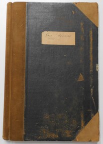
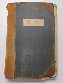
Document - LANDS OFFICE: REGISTER OF CROWN LAND LOTS SOLD BY PUBLIC AUCTION, 1951 - 1987
Document: hard cover journal, black cover with buff spine and edges. 89 pages entered with details of sales by public auction of crown lands. LH page: lot, county, town or parish, allotment, section, area, survey fee paid, upset price per lot, sold for per lot. RH page: value of improvements if any, name of purchaser, address, purchase money paid, grant fees and assurance paid.Lands Officeland sales, lands office, crown land, bendigo, kyneton, castlemaine, sea lake, girgarre, inglewood, echuca -
 Bendigo Historical Society Inc.
Document - LANDS OFFICE: SALE OF CROWN LANDS
Hard cover journal, green cover with buff spine and edges. Sticker on the front: Sale register 1934-1954. On the spine in red the number 16 and in black Land Sales 10-01-1934 to 31-12-1954. Pages entered with details of sales by public auction of crown lands. LH page: lot, county, town or parish, allotment, section, area, survey fee paid, upset price per lot, sold for per lot. RH page: value of improvements if any, name of purchaser, address, purchase money paid, grant fees and assurance paid.land sales, victoria, crown land sales, bendigo, central and northern victoria