Showing 216 items matching "dumping"
-
 Lakes Entrance Historical Society
Photograph - Dredging, Lakes Post Newspaper, 1992
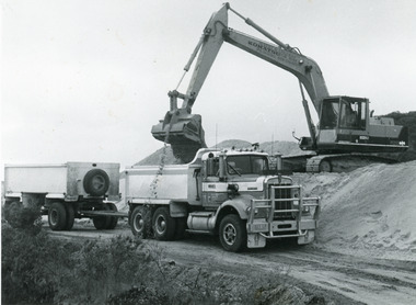
Date made June 1992Black and white photograph of heavy machinery loading sand into a truck and trailer on Bullock Island. This sand was dumped on the island during dredging operations at the entrance and around the Gippsland Lakes. Lakes Entrance Victoriaislands, dredging, machinery -
 National Wool Museum
Photograph
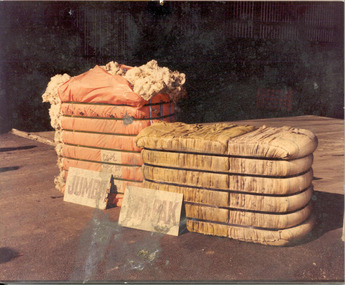
Hi-density dumped wool bales - Jumbo and Tri-Pak.JUMBO / TRI-PAKwool bales, wool bales high density, jumbo bales, tri-pak bales, wool bales - high density -
 National Wool Museum
Photograph
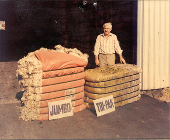
Hi-density dumped wool bales - Jumbo and Tri-Pak.JUMBO / TRI-PAKwool bales, wool bales high density, jumbo bales, tri-pak bales, wool bales - high density -
 Bendigo Historical Society Inc.
Photograph - HARRY BIGGS COLLECTION: REMAINS OF THE CLARENCE
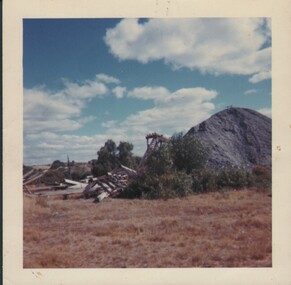
Coloured photograph of a tailings dump, there is a collapsed wooden structure to the left, a wooden stairway and part of another structure visible behind the mound and several small peppercorn trees growing. On the back is written 'Remains of the Clarence'place, mining site, clarence united mine bendigo, clarence mine -
 Ringwood and District Historical Society
Newspaper, Scrapbook Clipping, Library Collection, Ringwood, Victoria, `
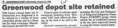
``Newspaper clipping from "The Post" 16-8-95 P 6 Greenwood depot site retainedThe former council depot site in Greenwood Ave, Ringwood is tio be utilised by a variety of local community groups and as a dump for street sweepings, Maroondah council decided this week. ` -
 Lakes Entrance Historical Society
Photograph - Bullock Island, Fish Marie, 2005c
Black and white photograph showing heavy machinery clearing the site of Pecks fish processing factory on Bullock Island, photo also shows dumped sand on island and Kalimna Heights in background. Lakes Entrance Victoriaislands, topography, machinery -
 Lakes Entrance Historical Society
Photograph - Bullock Island, Scarce, Keith, 1975 c
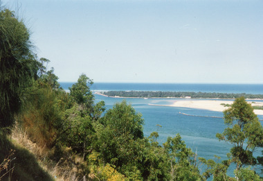
Second photograph showing part of Bullock Island and the entrance.Colour photograph of Bullock Island, after establishment of Pecks Factory and Fishermans Co-op, shows marram grass plantings to stabilise dumped sand. Rough surf breaking on offshore bar. Lakes Entrance Victoriawaterways, islands -
 Bendigo Historical Society Inc.
Newspaper - Article on the School of Mines Natural History Collection, Sat Mar 06 2021
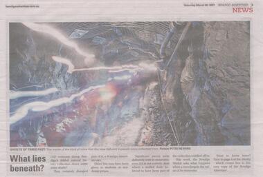
Bendigo once had an amazing natural history collection, then part of it was dumped down mine shafts.Bendigo Weekly: Full page article entitled 'What Lies Beneath us?' bendigo school of mines, bendigo tafe, bendigo natural history collection -
 Port of Echuca
Black and white photograph, Approx. 1975
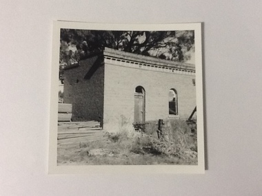
The old brick office buildings of the Murray River Sawmills were demolished around 1975. This photo relates to the series P000105-P000107. Sawmills in the Echuca area were historically and socially significant being a large employer in the area. The Murray River sawmill was one of the biggest and longest operating sawmills in the area. Black and white photograph of the old Murray River Sawmills, showing rear and side of the building with doorway and window. Lumber is piled at left front of photograph and other material (wire?) has been dumped in front of and along the side of the building.On reverse, in pencil, " M. R. Sawmills office or other old building, demolished". In pen "c.1975". Printed "Kodak paper". Blue ink"0932"murray river sawmills, echuca, echuca, victoria, pullicino, j -
 Lakes Entrance Historical Society
Photograph - The Entrance, Fish Marie, 1995
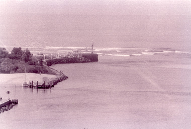
Black and white photograph of the Eastern Pier, taken from Jemmys Point. It shows the rock wall of the pier, rock groynes at the entrance to Cunninghame Arm behind which dredged sand has been dumped. Lakes Entrance Victoria waterways, piers -
 Bendigo Historical Society Inc.
Photograph - Kangaroo Flat Gold Mine Collection: mining equipment, 21st May 1999
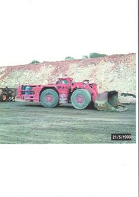
A bogger is a heavy-duty piece of equipment used in underground mining to transport rocks, ore, and other materials from the digging face to processing facilities or loading areas. A bogger operator is an individual who controls the machinery used to transport materials.Colour photocopy of original photo. Image shows red load haul dump loader, pictured parked on a mine road at the Kangaroo Flat Gold Mine site. Date stamp on bottom RH corner: 21/5/1999.western mining corporation, goldmining, capping, shaft, mining regulations, kangaroo flat gold mine, 1999 -
 Greensborough Historical Society
Slide - Photograph, John Ramsdale, Muddy Plenty River: Slide 93, 1990s
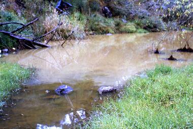
Photograph shows a muddy Plenty River with a small creek entering the river. Note the dumped car in background.Part of the John Ramsdale collection of slides and audio visual material.Colour photograph scanned from slide.No maker's marks. No caption on slide.plenty river, pollution -
 Stawell Historical Society Inc
Photograph, New Hospital under construction on the St George Sand Dump looking from Sloane Street
View from Sloane Street of St George Sand Dump site with New Hospital under construction.stawell hospital -
 Lakes Entrance Historical Society
Photograph - The Entrance, 1992c
Colour photograph of the western side of the Entrance. It shows scrub covered hummocks, dredged sand dumped at Snake Island, rock groynes from island to lake, taken from lower side of highway at Jemmys Point. Lakes Entrance Victoriaislands, topography, waterways -
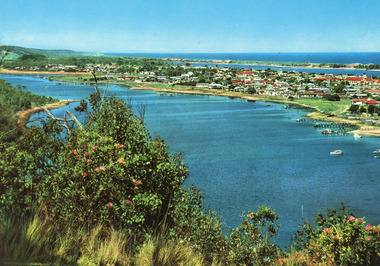
 Lakes Entrance Historical Society
Postcard - Lakes Entrance, The Rose Series, 1975
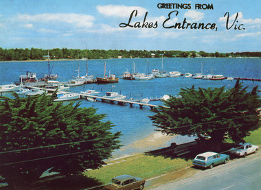
Sand dumping has commenced in preparation of works to modify and deepen Cunninghame Arm|Also one other copyColour postcard of the view of Cunninghame Arm, Lakes Entrance, from the Glenara Tower. Shows the western boat harbour with private cruisers and professional fishing vessels moored at wharf. Lakes Entrance Victoriawaterways, boats and boating, jetties, waterfront -
 Darebin Parklands Association
Rockbeare Park 1970s, Laurie Course, 1973-1980
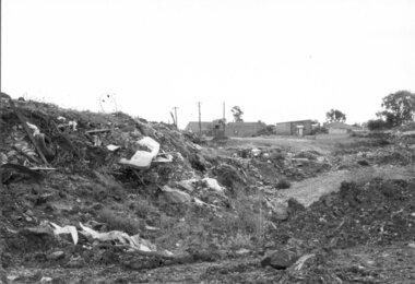
B&W photograph of trash dumped in the tip site. This item and all other Darebin Parklands Association archival material is now held by State Library Victoria (Accession No: YMS 13746). Please contact State Library Victoria if access is required. -
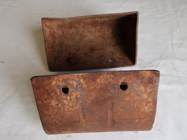 Kiewa Valley Historical Society
Steel Buckets - Mining
There was some gold mining in the Kiewa Valley and these buckets may have been used.Two small rusty looking steel buckets that are usually connected to a chain with many such buckets. They rotate to form a continuous chain scooping up loose rock and dumping it when mining. 20 cm x 12 cm x 9.5 cm deepgold mining -
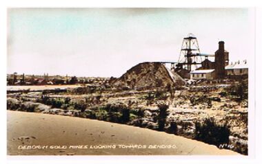 Bendigo Historical Society Inc.
Photograph - DEBORAH GOLD MINES ( NORTH DEBORAH ? )
Photo: Deborah Gold Mine ( un-named , possibly North Deborah ). Image shows poppet head, chimney, tailings dump. On Lh side of image, dam in centre foreground, On bottom of photo' Deborah Gold Mines looking towards Bendigo, No. 16 'bendigo, mining, deborah mine, bendigo, gold mines, deborah gold mine, mining -
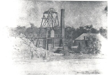 Bendigo Historical Society Inc.
Photograph - HARRY BIGGS COLLECTION: GOLD MINE
Photograph with a wooden Poppet head centre of frame, there is a trestle way out to a tailings dump on the left hand side. A square brick chimney is between the head frame and a wooden? Building on the right of the photo. In the foreground there is a roadway and a thick line of trees in the background. There are four copiesorganization, mining, head frame, poppet head, gold mine -
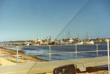
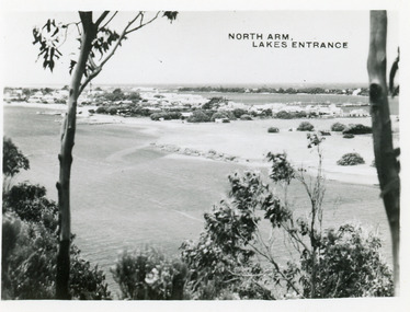 Lakes Entrance Historical Society
Postcard - North Arm Lakes Entrance, 1945c
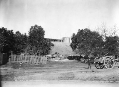
Photo taken soon after extensive dredging operations when tons of sand were dumped on low lying land at western end of town.Black and white small format postcard of the North Arm. It shows the township between North Arm and Cunninghame Arm. Lakes Entrance VictoriaNorth Arm Lakes Entrancewaterways, topography -
 Lakes Entrance Historical Society
Postcard - Lakes Entrance, Engelander John & Co Pty Ltd, 1980c
Panoramic view of Lakes Entrance taken by Melbourne firm for West Germany A.F.K. International Publishers of world's most famous beauty spotsColour postcard with serrated edge, of the township, situated between Cunninghame Arm and North Arm. Boats moored at jetties and beside boat ramps in North Arm. Photo taken from Kalimna Heights. Dredged sand dumped in North Arm bight. Lakes Entrance VictoriaLakes Entrance, Victoria, Australia (on back) waterways, topography, township -
 Lakes Entrance Historical Society
Photograph - Lakeside, Holding George, 1984c
Part of a series of seven colour photographs taken from same spot on the same dayColor photographs showing progress of extension to lakeside at the West boat Harbour, taken from the car park, showing many moored vessels. In the foreground the sand dredged from other areas and dumped in order to extend the car park and lakeside walkways. Lakes Entrance Victoriawaterfront, boats and boating -
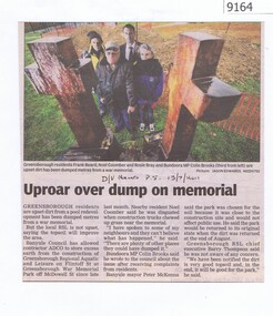 Greensborough Historical Society
Newspaper - Newspaper Clipping, Uproar over dump on memorial, 13/07/2011
Greensborough residents are upset at soil from a development in Greensborough being dumped at War Memorial Park in 2011. Includes a Letter to the Editor from a disgruntled Banyule resident in reply to this article.News clipping, black text, colour image.greensborough war memorial park, chainsaw sculptures -
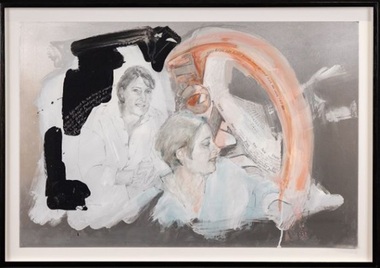 Wyndham Art Gallery (Wyndham City Council)
Painting, Kathy Vafiadis, Portrait of Joan Ryan, 2001
Born in Melbourne in 1950, Vafiadis studied at Prahran College of Advanced Education and has been exhibiting since 1971. Solo shows include Rigoletto at Fitzroy Gallery, Melbourne in 2005 and Mary Chirnside at Wyndham Cultural Centre in 2004. She has participated in various group exhibitions. She won the Wyndham Now Acquisitive Art Prize in 2000 and her work is held in several state and local council collections.Portrait of Joanne Ryan ( MP, member for Lalor). Jo was chair person of the Toxic Dump movement. A very strong and pivotal community leader during the campaign . Hence the use of metal. australian art, painting, portrait, australian politics -
 University of Melbourne, Burnley Campus Archives
Photograph - Black and white print, 464/31, 1951
Since about 1947 the Horticultural (Division) Enclosure was used as a dump for Pasture Branch supplies, which have been transferred recently to School Store for better appearance & greater convenience. 1951." EMG"The Horticultural (Division) Enclosure. horticultural enclosure, pasture branch, supplies, e. m. gibson collection -
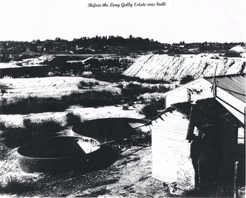 Bendigo Historical Society Inc.
Photograph - LONG GULLY HISTORY GROUP COLLECTION: LONG GULLY AREA
Copy of a black and white photo of the Long Gully Area before the Long Gully Estate was built. On the right is a small and a larger buildings. Beside the buildings are two large open vats. One has a pipe with liquid flowing into the vat. The centre of the photo is mostly sand dump and tussocks. In the background is bush and houses.bendigo, history, long gully history group, the long gully history group - long gully area -
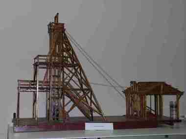 Federation University Historical Collection
Unknown - Model, Poppet Head Model
This scale model of a mining plant was made by Donald Douglas Mather of Talbot. The engine shed houses the winches, which raise and lower the cages carrying the workmen. The winches also control the water-Baling tanks, which are lowered into the pump shaft to clean the water. The Pump Shaft is part of the main shaft partitioned off for keeping the water down. The old style plant (or cas commonly known poppet legs), were all of timber construction and, when erected, straddled the main shaft. This scale model allows for steel construction, and is set over the shaft to permit an unobstructed view of the operations. The Bad level is where the workmen enter and leave the shaft. The staging platform on the first level is where the trucks and mullock or other material are wheeled out on rails and then tipped to form the mine dump. The top level is to allow for maintenance of plant. Donald Douglas Mather of Talbot worked in mines in Ballarat, and made the model of the poppet head. The poppet head is a replica of those used at many mines in Ballarat. Back in the 1850s Ballarat was a god rush town and many mining claims were made and poppet heads built this is a replica of those poppet heads which are a part of Ballarat's Heritage and a full size poppet head is erected at Sovereign Hill Theme Park in Ballarat. Mining is a huge part of Ballarat's history.A timber poppet head and engine room model. "This scale model - the modern construction of a mining plant - was made by Mr Donald Douglas Mather* of Bonnie Doon, Talbot, Victoria. The engine shed houses the winches, which raise and lower the cages carrying the workmen. The winches also control the water-baling tanks, which are lowered into the pump shaft to clean the water. The pump shaft is part of the main shaft partitioned off for keeping the water down. The old style plant (or as commonly known poppet legs), were all of timber construction and, when erected, straddled the main shaft. this scale model allows for steel construction, ans is set over the shaft to permit an unobstructed view of the operations. The bad level is where the workmen enter and leave the shaft. The staging platform on the first level is where trucks ad mullock or other material are wheeled out on rails and then tipped to form the mine dump. The top level is to allow for maintenance of plant. * Mr Mater, previously of Ballarat, worked for many years as a miner and plant erector" (Old interpretive panel)mining, mather, mining plant, poppet head, engine house, model, donald douglas mather -
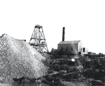 Bendigo Historical Society Inc.
Photograph - AUSTIN COLLECTION: POPPETHEAD AND MINE BUILDINGS
Black and white photograph: image shows a mine site with mulloch dump LH side; poppet head in centre and corrugated iron mine building on RH side. At rear of building is a boiler. A large chimney, possibly metal, at front of building. Possibly Central Nell Gwynne Mine although un-named on photograph.bendigo, mining, mine site -
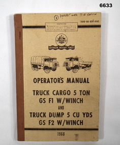 Bendigo Military Museum
Manual - VEHICLE OPERATORS, Commonwealth Dept of Supply, Maribyrnong 3032, 1968
This is a cardboard covered book. The front cover is khaki. It shows drawings of the cargo F1 Truck and Dump truck F2. It is an operations Manual. At top and bottom of front cover is a black bar, The book is army part NR 7610-66-028-4143. The book has 49 pages. It has photos drawings and specifications.Front cover has written in ink (1) 3-12-9865 WO2 T.B. Caffin, inside has the same soldier.passchendaele barracks trust, truck manual, army -
Port Melbourne Historical & Preservation Society
Book - Port Melbourne Council, J Harrop, Sanitary Inspector, Sanitary Inspectors Report Book, 1900 - 1905
Sanitary Inspector's Reports to Port Melbourne Council 1900-1905, detailing infectious diseases reported, nuisances, smells, smoke, drain sewerage leaks, illegal dumping of manure and other refuse, animals found wandering, inspections of premises, tips, piggeries, factories, fumigating, laying baits, carrying out orders of Health Officer.local government - town of port melbourne, environmental issues, health - general health, business and traders, industry - noxious, nightsoil, engineering - canals and drainage, built environment, livestock, j harrop - sanitary inspector, dr sandford - acting medical officer