Showing 215 items matching "dunes"
-
 Lakes Entrance Historical Society
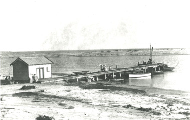
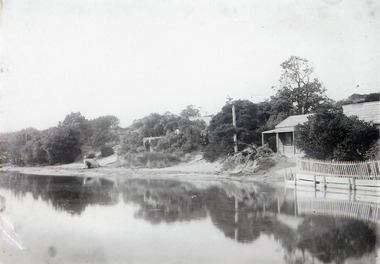
Photograph - Snowy River.Marlo Victoria, 1910 c
Black and white photograph showing four small boats at jetty near mouth of Snowy River. Shed at left crane at end of jetty. Three ladies walking on jetty and people in front of shed and three people sitting in shade of shed at left. Trolly on rails on jetty, sand dunes across river and ocean beyond dunes Marlo Victoriarivers, boats and boating, jetties -
 Lakes Entrance Historical Society
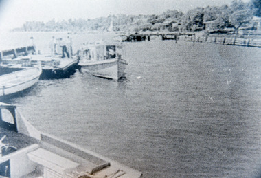
Photograph - New Works Jetty, 1930c
Black and white photograph showing boats at New Works wharf. Small boats at jetty on left, cottages on dunes at right. Lakes Entrance Victoriaboats and boating, jetties -
 Lakes Entrance Historical Society
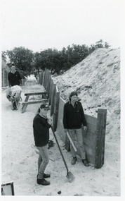
Photograph, Lakes Post Newspaper, 1992
Article appeared in Lakes Post 28 October 1992, 'At work on the new retaining wall leading to 90 Mile Beach, staff from the Department of Conservation and Natural Resources, (L-R) Ken Judd, Jason Bice and David Harper'.Black and white photograph of three workers, building pathway and retaining walls through the sand dunes. Coastal banksia in background. Lakes Entrance Victoriawaterfront, parks, room display -
 Lakes Entrance Historical Society
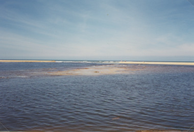
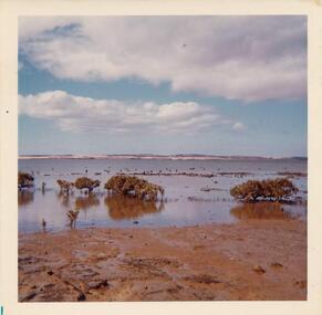
Photograph - Lake Tyers, M Holding, 1/06/1998 12:00:00 AM
Second colour photograph similar view number 03836.1 size 10x15 cmColour photograph taken after Lake Tyers has broken through the dunes to the sea showing surf breaking on the entrance Lake Tyers Victoria tourism, waterways, beaches -
 Phillip Island and District Historical Society Inc.
Photograph
Part of a collection presented by Miss Edith Elms via Chrisy Northcote.Westernport Bay at low tide showing line of low mangroves 1/3 from bottom. Brown foreground, low line of sand dunes in background.local history, photography, photographs, seascapes, westernport, coloured photograph, san remo -
 Orbost & District Historical Society
black and white photograph, first half 20th century
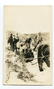
Access to the cottages at the lighthouse was difficult and the horse-drawn sled was in use until the 1940s. It was used to haul personal goods as wel as those needing medical attention at far-off Orbost. This photograph could be connected with the Gledhills in the 1930s when a medical emergency necessitated a removal to Orbost. Dr Nettleton was the doctor at Orbost at that time. (there could be a link through donor) Point Hicks is claimed to be Captain James Cook’s first sighting of mainland Australia. The lighthouse was built on the point during 1887 and 1888 and commenced operation in 1890, built from concrete and with timber keepers quarters. It was connected to mains electricity in 1965, and then to solar power recently. Originally access to Point Hicks was by sea. In 1920 a return trip, by land to Cann River, 47 kilometres away from the light station, took two days. By 1946 the journey had been reduced to 36 hours by a combination of horse and jeep. During the early 1950s it was still a 12-hour ordeal. The light no longer works, it was turned off 21 years ago and the Point Hicks lighthouse is now powered by a much smaller, more modern light. the lightkeepers' cottages are used for tourist accommodation.This photograph is associated with Point Hicks, a historically important lightstation in East Gippsland.A small black / white photograph of a horse dragging a sled with suitcases on it. There are seven people walking behind, one holding the reins. They are waalking through a sand dune.on label on back - "Bring Out to Light House keeper from Point Hicks"point-hicks-lighthouse -
 Lakes Entrance Historical Society
Photograph - Bridges, Lakes Post Newspaper, 1999
Image appeared in Lakes Post 19 May 1999|Also two other photographs similarColour photograph of repairs to the Cunninghame Arm Footbridge, shows Burys Slipway barge and workmen. Surf Lifesaving Clubroom on dunes in distance. Lakes Entrance Victoriabridges, waterways, topography -
 Lakes Entrance Historical Society
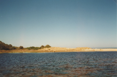
Photograph - Lake Bunga, M Holding, 1990c
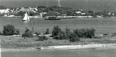
Colour photograph of eastern shore near the entrance to ocean, the low area between upland and sand dune indicating the original waterway Lake Bunga Victoriatopography, waterfront -
 Lakes Entrance Historical Society
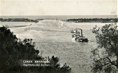
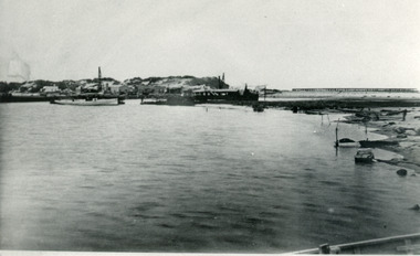
Photograph - The Entrance, Segerberg and Bulmer, 1910 c
Also enlargement 17 x 23 cmBlack and white photograph showing view from Jemmys Point of the entrance to the Gippsland Lakes from Bass Strait. Pioneer dredge in centre foreground, and steamer JCD. Cottages and works buildings including Rocket shed on eastern dunes, Schnapper Cottage on far right western dune. Rock groynes and tip of Bullock Island centre left. Vegetation in foreground. Lakes Entrance VictoriaLAKES ENTRANCE Segerberg and Bulmerships and shipping, topography, jetties, houses -
 Hume City Civic Collection
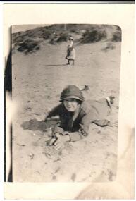
Photograph, 1920s
A copy of a snapshot of a woman lying on the sand. She is wearing a hat and coat. Another woman is in the middle distance and is half turned towards the camera. There are sand dunes in the background.headwear, 1920s, george evans collection -
 Lakes Entrance Historical Society
Photograph, Todd, Della, 1945c
Black and white photograph of the footbridge over Cunninghame Arm. It shows the scrub covered sand dunes of the south shore in the foreground, footbridge in background. Lakes Entrance Victoria waterfront, topography -
 Port Fairy Historical Society Museum and Archives
Photograph
... dunes ...Black and white Photograph of the East Beach looking North from Battery Lane with people bathing in the middle groundeast beach, ocean, beach, sea, dunes -
 Lakes Entrance Historical Society
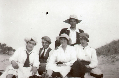
Photograph - Harbeck/Coate/Bliss, 1918
Black and white photograph of Vi Coate, Elgar Mann,Nell Bliss, Eva Harbeck and another Miss Harbeck and one man sitting on the sand dunes at Lakes Entrance clothing, genealogy -
 Lakes Entrance Historical Society
Photograph - Carpentertown, Phillips Miss L, 1910c
Two other black and white copies, one 9 x 14 cm, second 11 x 21.5 cmSepia photograph showing houses on dunes at New Works. House on right is harbour engineer's house, next Carpenter house, PWD jetty in front. Lakes Entrance Victoriajetties, houses, boats and boating, topography -
 Lakes Entrance Historical Society
Photograph - Palmers Rd. Lakes Entrance 1927, Edie Jemmeson, 1927 c
This photograph was used in the 150 year Lakes Entrance 1858 to 2008 display as the before picture paired with colour photograph number 03727.1 as the after picture size 10 x 15 cm road now paved with many buildings showingHistoricBlack and white photograph of Palmers Road looking south towards the sand dunes and ocean, teatree along the side of the road photographers shadow in foreground, Lakes Entrance Victoriatopography, sand dunes -
 Lakes Entrance Historical Society
Postcard - Backwater, Bulmer H D, 1922c
Black and white photographic postcard, showing early aerial view of township of Lakes Entrance, Cunninghame Arm, North Arm and sand dunes, ocean in lower foreground, Eastern wharf and various boats on lake. Princes Highway went along Esplanade, Myer Street and Roadknight Street, very little vegetation on sand dunes, no foot bridge yet, good view of North Arm, few houses. Lakes Entrance VictoriaLakes Entrance and Backwater from the Air.islands, aerial photograph, waterways, topography, township -
 Lakes Entrance Historical Society
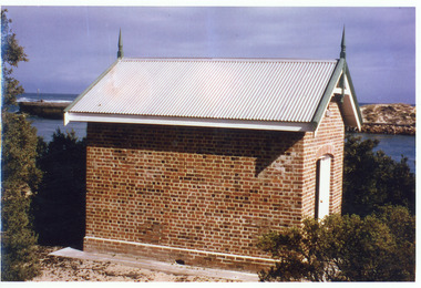
Photograph - Rocket Shed, 1997 c
Rocket shed (built 1890) was used to store rockets used to warn ships coming through the entrance of dangerous conditions.Colour photograph showing brick rocket shed on sand dune at the entrance to the ocean. Scrub around shed, entrance and western pier behind and ocean in distance. Lakes Entrance Victoriaships and shipping, historic buildings -
 Lakes Entrance Historical Society
Photograph - New Cottages, 1910c
Black and white photograph showing cottages on dunes, nearest cottage, At Rest, next one The Beacons, Cunninghame Arm in front. Picket fence in front of At Rest, at Lakes Entrance, Victoria.houses, waterfront -
 Lakes Entrance Historical Society
Photograph, 1940c
Prior to shed being built, equipment stored in Kiosk|This is the before paired photograph used in the 150 year Lakes Entrance 1858-2008 display.|The after paired photograph number is 01538.1|Also one 12 x 16 framed photograph use in room display.Black and white photograph of eight adults and child at the southern end of the footbridge. Wooden path, sand dune, and Royal Lifesaving Tower and equipment shed in distance. Lakes Entrance Victoriawaterfront, bridges, people -
 Phillip Island and District Historical Society Inc.
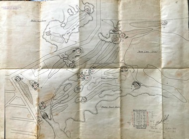
Map, Map of Summerland Golf Course, 15/12/1927
Summerland Estate was created in the 1920s by A.K. T. Sampbell. It consisted of a housing estate, guest house and golf course. This area was acquired and all buildings, roads etc removed by the Victorian Government in the 1980s for a nature reserve for the penguins. This is believed to be the only time in the world when humans have been removed to benefit nature. HistoricalPurple leather covered fold out linen map with hand drawn diagram of the topography, layout of golf holes and club house Broken sand dunes, rough sandy hills, grassy hills and mounds, Swan Lake, Par for nine holes 34, Scratch score for nine holes 36, Drawn by A. Russell 12/12/1927summerland estate, a.k. t. sampbell, map, penguin reserve, summerland golf course -
 Lakes Entrance Historical Society
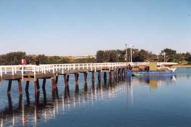
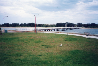
Photograph - Footbridge, 1999c
This photo taken from township side (northern side looking southward)Color photograph of the footbridge across Cunninghame Arm. It shows the shortened footbridge with the path and recently established lawn and trees. Surf lifesaving club on sand dunes in background. Lakes Entrance Victoria waterfront, bridges -
 Lakes Entrance Historical Society
Photograph - The Entrance, 1885c
Also two identical copies|Also one 9 x 13 potograph in spares boxBlack and white photograph showing building of the entrance piers. Works building and houses on dunes at left, partially built pier on right background. Wombat dredge in centre. Lakes Entrance Victoriajetties, waterways, public works, historic buildings -
 Lakes Entrance Historical Society
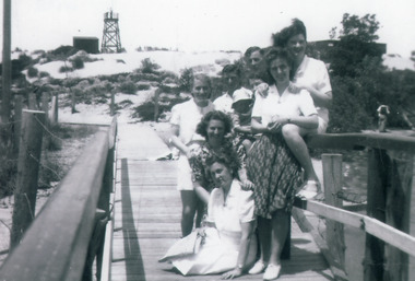
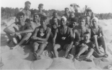
Photograph - Surf Lifesaving, 1938
also b & w enlargement 17.5 x 25.5, )Black and white photograph group of men and boys, members of Life Saving Club sitting on sand dunes, two persons identified as Jack Mitchelson and Tommy Todd. Lakes Entrance Victoriavolunteering, community services, emergency services -
 Lakes Entrance Historical Society
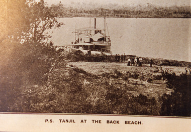
Photograph - P.S. Tanjil, 1910 c
Sepia photograph of postcard showing P S Tanjil at the back beach. People near shoreline, vegetation on dunes, western end of Boole Poole peninsula in background. Gippsland Lakes, VictoriaP S Tanjil at the Back Beachships and shipping, waterways, beaches -
 Lakes Entrance Historical Society
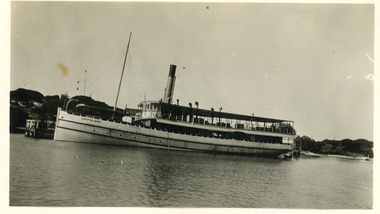
Photograph - S.S. Gippsland, 1913 c
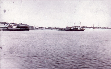
Black and white photograph showing the S S Gippsland at the New Works wharf. Sand dunes in background with signal semaphores on flagstaff on top. End of wharf on left. Lakes Entrance Victoriaships and shipping, jetties -
 Lakes Entrance Historical Society
Photograph - Lake Tyers, Lakes Post Newspaper, 1/08/2001 12:00:00 AM
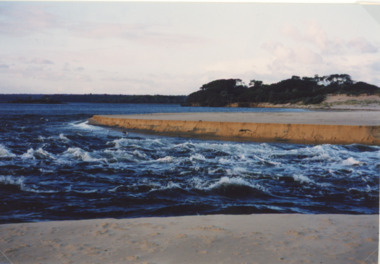
Colour photograph showing turbulant water at the new entrance at Lake Tyers showing western barrier of the lake in background and sand dune in foreground being washed away Lake Tyers Victoriawaterways, beaches -
 Lakes Entrance Historical Society
Photograph - Surf Lifesaving, 1938
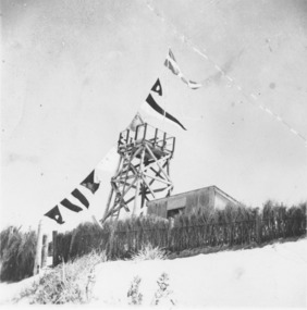
Black and white photograph timber construction of Surf Lifesaving tower and equipment shed on sand dunes behind brush fence, flags strung from tower flagpole to fence. Lakes Entrance Victoriacommunity services, emergency services, beaches -
 Lakes Entrance Historical Society
Photograph - Carpentertown, 1920c
Copied from copy in J Whadcoat collectionBlack and white photograph showing P W D cottage on left and other Works buildings on dune at the entrance to Gippsland Lakes from the ocean - Bass Strait. View shows flagstaff on top of dune and flagstaff jetty in lake - Cunninghame Arm. Small sailing boat on left and other small craft on shoreline. Section of Bullock Island with vegetation, one telegraph pole and one dead tree on island. Shoreline of North arm in foreground. Lakes Entrance Victoriajetties, waterways, settlement, historic site, boats and boating -
 Lakes Entrance Historical Society
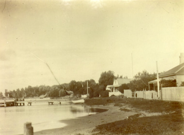
Photograph - New Works, 1890c
Three copies -Sepia photograph showing dunes, houses and Works buildings and boats at the entrance to Gippsland Lakes from ocean - Bass Strait. Photo shows two PWD houses on left and small school building, plus other Works buildings. Flagstaff on dune above houses. Large barge on left in front of houses. Large passenger steamer at New Works wharf with people waiting, has flags and bunting, two masted ketch on right of rock groynes. Lakes Entrance Victoriajetties, boats and boating, settlement, historic site -
 Port Fairy Historical Society Museum and Archives
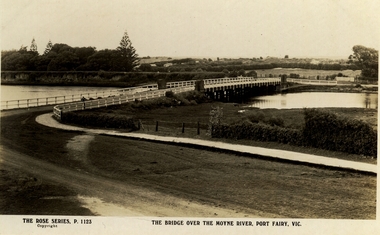
Postcard, The Rose Series / The Rose Stereographs, The Bridge over Moyne River, Port Fairy Vic
... dunes ...Black and white Photograph of the Moyne river road bridge with the botanical gardens in the left background and some huts built possibly on Hughes AvenueThe Rose Series P.1123 copyright.- The Bridge over the Moyne River Port Fairy Vic.moyne bridge, hughes avenue, gipps street, river, dunes, botanical gardens