Showing 73 items matching "early burial"
-
 Eltham District Historical Society Inc
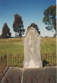
Photograph - Digital Photograph, Alan King, Graves of Thomas Sweeney and family, Eltham Cemetery, Victoria, 27 January 2008
The grave of Thomas Sweeney, former convict turned respectable citizen. The Murray and Sweeney families were both early settlers of the Eltham district and connected by marriage. Their family plots are located side by side in the Catholic section of the Eltham Cemetery. Irish-born Thomas Sweeney is regarded as the first settler in Eltham. He was transported to Sydney in 1823 after being convicted of arson. He was granted his freedom in 1838 and married Margaret Meehan in the same year. They moved to Melbourne and in 1842 Thomas purchased 110 acres beside the Yarra River in the vicinity of present-day Sweeneys Lane. He called the property ‘Culla Hill’ and built a small slab hut (reputedly with Wurundjeri help; Margaret is said to have run an informal hospital for them in return). This was followed in 1846 by more substantial buildings consisting of a three-roomed Irish-style ‘longhouse’ and a barn made of stone and handmade bricks, with doors large enough to accommodate a fully loaded wagon. When the gold rush came, Thomas prospered by selling meat and potatoes to the prospectors, enabling him to purchase a further 308 acres in 1856. He promoted the construction of a bridge over the Plenty River and the establishment of a school at Eltham. Roman Catholic Church services were held at Culla Hill in the early years. When he died in 1867, he was regarded as a respected member of the community. Thomas and Margaret are buried in Eltham Cemetery with many of their descendants. Their first son John continued to farm Culla Hill until his death in 1909. Culla Hill passed out of the Sweeneys' possession in 1939. The house and barn remain today, though lesser outbuildings have gone. The facade of the house is much the same as it was in the 1840s. Sacred To the memory of Thomas Sweeney Who died Sep 6th 1867 Aged 65 years May his soul res in peace Also his wife Margaret Died Oct 3rd 1884 aged 73 years And their daughters Annie Died Aug 22nd 1860 aged 21 years Johanna Died Aug 19th 1872 aged 22 years Margaret Died 7th Sep 1913 aged 72 years R.I.P. Also In Memory Of John Sweeney Died 24th May 1909 Aged 65 years Also of his wife Ellen Died 8th March 1910 Aged 64 years R.I.P Also In Memory Of Caroline Infant daughter of John & Ellen Sweeney Published: Nillumbik Now and Then / Marguerite Marshall 2008; photographs Alan King with Marguerite Marshall.; p55 From the piety and poverty of 19th century Eltham, 20th century artists and environmentalists, to today’s comfortable middle class, Eltham Cemetery records it all — and more. A visit to Eltham Cemetery reveals an important social record since its beginnings in 1858. The cemetery was situated on about six acres (2.4ha) (now around 4.8ha) at the corner of Mount Pleasant and Metery Roads.1* It is thought that Metery Road was originally called Cemetery Road, but in the early 1940s, a resident, possibly a councillor, objected to the name resulting in the change.2 Much can be gleaned about the developing Eltham community from burial styles and the names of former local residents. Originally the cemetery was divided into Christian denominations, like others of that time, following the United Kingdom burial system. In 1861 the cemetery included Church of England, Presbyterian, Roman Catholic and Wesleyans (later Methodist) sites. Graves also indicated social class. Some had grand tombstones, perhaps fenced with ornamental cast iron railing, but most in the 1860s and 1870s were constructed of modest stone slabs.3 This indicated the poverty of the district, which was largely inhabited by farmers on small landholdings. A poignant reminder of the high rates of infant mortality of those times, are the many infants and young children recorded on the headstones. Major changes occurred in the cemetery in the late 20th century as Christian adherence weakened and society became more egalitarian and informal. In the early 1970s a non-denominational lawn section for burials was established. Since then all new areas have been non-denominational to accommodate the more diverse local community. Now, instead of large ornamental headstones, some mourners have chosen boulders, reflecting the natural Eltham style, while others choose graves in the lawn areas or niches in walls. In the late 1970s, the University Donor Section was established north-west of Candlebark Lawn for those who donated their bodies for The University of Melbourne medical research. In the early 1980s the natural Australian garden style, popular in Eltham, was mirrored in a new section called Ashes Walk. Local landscape architect Gordon Ford, who had popularised this style, designed the Walk using boulders shaded by native plants beside curved pathways. Landscape architect Robert Boyle later redesigned Ashes Walk and developed other parts of the cemetery in keeping with this style.4 Appropriately Ford, who died in 1999, was interred in the Native Garden Section in a cluster of sites shaded by a large eucalyptus tree.5 By 2007, about 6400 interments were recorded in the Eltham Cemetery. Close inspection reveals notable names in the district’s history. The grave of Thomas Sweeney, a former convict who became a respected citizen, can be found in the Roman Catholic section near the path. Eltham Primary School’s first headmaster, David Clark, is buried in a modest grave in the Church of England section to the east of the path from the main entrance. Sir William Irvine, Victorian Premier from 1900 to 1902, whose grave is in the north-east Presbyterian section was at various times Victoria’s Chief Justice, Deputy Governor and Treasurer.6 Further south is the grave of social reformer Bertram Wainer, born in Scotland in 1928 and died in 1987. He campaigned to legalise abortion and exposed police corruption in allowing illegal ‘backyard’ abortions. Other prominent local residents interred in the cemetery include: Justus Jörgensen, who founded Montsalvat; Alistair Knox, the mud-brick housing pioneer and Eltham Shire Councillor from 1971 to 1975 and President in 1975; Clem and Nina Christensen, who had a major influence on the literary development of post World War Two Australia. Others were: composer Dorian Le Gallienne; artist Peter Glass; Stephen Dattner, a prominent Melbourne furrier; ALP parliamentarian for Greensborough, Pauline Toner and political scientist and commentator, Professor William Macmahon Ball.This collection of almost 130 photos about places and people within the Shire of Nillumbik, an urban and rural municipality in Melbourne's north, contributes to an understanding of the history of the Shire. Published in 2008 immediately prior to the Black Saturday bushfires of February 7, 2009, it documents sites that were impacted, and in some cases destroyed by the fires. It includes photographs taken especially for the publication, creating a unique time capsule representing the Shire in the early 21st century. It remains the most recent comprehenesive publication devoted to the Shire's history connecting local residents to the past. nillumbik now and then (marshall-king) collection, annie sweeney, caroline sweeney, ellen sweeney, eltham cemetery, graves, gravestones, johanna sweeney, john murray, john sweeney, margaret sweeney, mary ellen drain, mary murray, thomas murray, thomas sweeney -
 Eltham District Historical Society Inc
Photograph - Digital Photograph, Alan King, Queenstown Cemetery, Smiths Gully Road, St Andrews, 28 December 2007
The discovery of gold in Smyth's Creek in 1854 and subsequent gold rush to the Caledonia diggings led to the establishment of Queenstown (present day St Andrews). The first recorded burial was July 31st, 1861 and it was officially declared a Cemetery Reserve in 1866. Many graves are unmarked and unrecorded including many Chinese and other itinerant miners. The cemetery was closed for new burials in 1851. The last recorded burial was in 1981 in an existing family grave. In Loving memory of David Band Died 30th Decr. 1862, aged 51 years. John Cork Knell Died 11th April 1867, aged 42 years. Eliza Smith Died 20th Jany. 1874, aged 3 1/2 years. William Band Died 20th Feby. 1883, aged 51 years. Published: Nillumbik Now and Then / Marguerite Marshall 2008; photographs Alan King with Marguerite Marshall.; p73 The discovery of gold at Smyth’s Creek* in 1854 brought 3000 people to the area in search of their fortunes.1 However in the harsh conditions many miners and their families died young, and were buried in unmarked graves. Their stories died with them but by 1861, the first burial was recorded at the Queenstown Cemetery – that of William Dalrymple aged 65 – although the cemetery was only officially declared a reserve in 1866. Even before this in 1856, a double burial had been recorded for the twin baby daughters of George Harrison at Market Square, the miners’ settlement – presumably where the cemetery is today. In 1951 the Queenstown Cemetery at 70 Smiths Gully Road, Smiths Gully, closed for burials. However the last burial in a family plot, that of Grace Evelyn Smith, occurred in 1981. Today only 55 headstones remain, but more than 380 burials are recorded. Remnant bushland dominates the cemetery where many graves are merely mounds and others have been damaged by vandalism and the neglect of time. Bushfire in 1962 destroyed the picket fencing, grave markers and cypress boundary planted in the early 1900s. The box/stringybark woodland in the 1.7 hectare Cemetery Reserve is regrowth from then and the indigenous and heritage vegetation is protected. Thanks to the volunteer Cemetery Trust and Friends & Relations of Queenstown Cemetery, the cemetery is maintained, stories recorded and the burial index corrected and expanded.2 Close by the cemetery on the site of today’s Peter Franke Picnic and Nature Reserve stood Market Square, the Caledonia Diggings village of tents and stores, the forerunner of Queenstown, now St Andrews. Many of the Caledonia Diggings miners were Chinese, many of whom, with itinerant prospectors, were buried in unmarked graves. Histories are being recorded of other immigrants, mainly English and German, who settled after the gold rush, some of whose descendants fought and died in the two world wars. Names on many headstones are also recorded on the district’s roads, reserves and war memorials such as Motschall, Joyce, Howard and Coutie. The oldest surviving tombstone is that of Scot, David Band who died in 1862 at 51 years. His oldest daughter Elizabeth, with husband John Knell, owned the Queenstown Hotel and the post office. Child-rearing in a colonial gold town was often tragically difficult, as demonstrated in the first 20 years, when 41% of the 34 burials recorded were children. Settlers endured harsh conditions graphically illustrated with the deaths of Annie Joyce at 30 years and of her family. Annie was married to gold miner Walter Joyce. Their third child Walter, born in 1886, died in March 1887. Eight months later Annie died of breast cancer. Walter died in 1909, aged 53, of miner’s phthisic caused by stone dust destroying his lungs. It was so hard to make a living that burials were usually held from 2.30 pm to allow mourners to work a day before paying their last respects.3 Most burials before 1890 were recorded as Anglicans, as the only church on the Caledonia Diggings was the Church of St Andrew, until 1897, when the Primitive Methodist Church came to Panton Hill. Generally miners came to better themselves, but some, like Grace Hopkinson (nee Milward), born in England in 1828, came from a well-off and educated family. According to family legend Grace emigrated with husband William, to live in a tent, but had kept her personally embossed sterling silver cutlery service. Amid the tough environment were some successes like that reported in The Evelyn Observer April/May 1901 of miner William Hopkinson who was buried at the cemetery in 1912 aged 81. The Observer stated that Hopkinson ‘recently dropped across another find in his claim at One Tree Hill’. The lump of gold found this time weighed more than half a kilo. Mr Hopkinson referred to it as ‘another little speck’. *Today’s Smiths GullyThis collection of almost 130 photos about places and people within the Shire of Nillumbik, an urban and rural municipality in Melbourne's north, contributes to an understanding of the history of the Shire. Published in 2008 immediately prior to the Black Saturday bushfires of February 7, 2009, it documents sites that were impacted, and in some cases destroyed by the fires. It includes photographs taken especially for the publication, creating a unique time capsule representing the Shire in the early 21st century. It remains the most recent comprehenesive publication devoted to the Shire's history connecting local residents to the past. nillumbik now and then (marshall-king) collection, david band, eliza smith, gravestones, john cork knell, queenstown cemetery, smiths gully road, st andrews, william band -
 Eltham District Historical Society Inc
Photograph - Digital Photograph, Alan King, Cameron family graves, Kangaroo Ground Cemetery, Eltham-Yarra Glen Road, Kangaroo Ground, 28 January 2008
Six year old Judith Furphy was the first person known to have been buried at Kangaroo Ground Cemetery in May 1851. The cemetery is situated on an ancient river bed with exposed Nillumbik sands. The rest of the district is formed from black volcanic soil which was hard to dig. According to local historian Mick Woiwod (deceased) the site may have been a burial ground for the local Wurundjeri people as the exposed softer sands were always their prefered camping sites. The Hon. Ewen Hugh Cameron who lived at Pigeon Bank and was the Member for Evelyn for 40 years (1874-1914) was buried here in 1915. Published: Nillumbik Now and Then / Marguerite Marshall 2008; photographs Alan King with Marguerite Marshall.; p39 The Wurundjeri people might have buried their dead on the site of the Kangaroo Ground Cemetery, according to local historian Mick Woiwod. Kangaroo Ground was a premier hunting ground, but camping on the black volcanic soil would have been uncomfortable. Unlike most of Kangaroo Ground, its cemetery, on an ancient river bed, comprises a rare exposure of Nillumbik sands – always the preferred campsite for Aboriginal people. The cemetery area is the only place where the soil was soft enough to dig a grave easily.1 Six-year-old Judith Furphy was the first person known to have been laid to rest at the Kangaroo Ground Cemetery. She died on May 17, 1851, from a chill caught by resting on wet grass. Local Andrew Ross wrote ‘..no public burying place existed nearer than Melbourne. The case being considered urgent, a general meeting of the settlers took place on the evening of the 17th……. The result was the selection of unoccupied crown land …….which was subsequently granted by Government for a public cemetery.’2 Judith was buried the next day on May 18. Her grave was marked by the trustees with a plaque, which unfortunately states nine years old, when she was probably only six. Judith came from an illustrious family. Her brother, Joseph, was the author of Such is Life and other works. Another brother, John, developed and manufactured the famous Furphy water cart, which distributed water to World War One soldiers along with the latest rumours. Hence the name Furphy entered the Australian idiom, as synonymous with ‘rumour’. Judith’s father Samuel helped build the first Kangaroo Ground church school. Inside, near the entrance of the cemetery, on Yarra Glen Road, stand a rotunda and a water tank. Occasional benches invite mourners to pause and remember. The gate with wrought iron and brick supports, bears the inscription ‘Erected by Sir Ewen and Lady Cameron in memory of their daughter, Flora Margaret’. These are only two of the famous people connected with this cemetery. The Hon. Ewen Hugh Cameron JP and MLA from 1874 to1914, who lived at Pigeon Bank, Warrandyte Road, was buried here in 1915. Unrelated, but with the same name, was Sir Ewen Cameron who had been Minister for Health and was laid to rest there in 1964. Sir Herbert Gepp, a leading industrialist and the former owner of Garden Hill, at Yarra Glen Road, was buried there in 1954.3 Many of the more imposing tombstones belong to the earlier graves. Unfortunately bushfires have cracked several. But this adds to the melancholy attractiveness of the cemetery, graced by some beautiful eucalypts, cypress and pines. Early pioneering families represented at the cemetery include Armstrong, Barr, Bell, Harkness, Jardine, Johnston, Rogerson, Stevenson, Thomson and Walters. Armstrong and Bell were among the first families to come to the district and Stevenson owned the district’s first sheep station. It took in much of present day Christmas Hills, which was the name he gave his sheep station. Harkness was the first to suggest a Kangaroo Ground school be built, and one of the first to suggest establishing the Eltham District Road Board. Many of these families leased pastoral land before the mid-century and bought land when it came on sale in 1849. In the cemetery’s early days sections were devoted to the major Christian denominations (mainly the Protestant) and one section was set aside for ‘other’ or ‘non-believers’. However in modern times burial plots have not been placed in areas according to religious beliefs.This collection of almost 130 photos about places and people within the Shire of Nillumbik, an urban and rural municipality in Melbourne's north, contributes to an understanding of the history of the Shire. Published in 2008 immediately prior to the Black Saturday bushfires of February 7, 2009, it documents sites that were impacted, and in some cases destroyed by the fires. It includes photographs taken especially for the publication, creating a unique time capsule representing the Shire in the early 21st century. It remains the most recent comprehenesive publication devoted to the Shire's history connecting local residents to the past. nillumbik now and then (marshall-king) collection, kangaroo ground, eltham-yarra glen road, agnes bell cameron, agnes cameron (nee bell), cameron family, edward aubrey haughton, eugene cameron, evelyn florence cameron, ewen hugh cameron, gravestones, jane armstrong, jane bell, jessie agnes haughton (nee cameron), jessie cameron, john donald cameron, kangaroo ground cemetery, neville cameron, simon armstrong, vera cameron, william bell armstrong, wurundjeri -
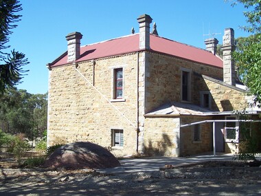 Bendigo Historical Society Inc.
Document - Rocky Vale Beebe House, 2010 to 2015
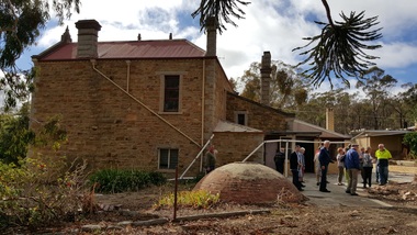
The Beebe name was well-known in Bendigo in the last quarter of the 19th and the early part of the 20th centuries. From 1875, William Beebe senior, monumental mason, occupied a site in the centre on the city, in Mitchell Street opposite King Street. Death was more part of life in those days, and the Beebes were there to provide the burial monuments. Later, he took his sons into the business, which grew as Beebe and Son. Many examples of their work can be found in the local cemeteries. William Beebe senior (1830-1891) was born in Rutland, the smallest English county in 1830, to stonemason Chamberlain Beebe and Susannah Clements. William emigrated to Victoria in 1854 and after engaging on unknown works in Port Fairy, Dunkeld, and Melbourne arrived in Bendigo. His obituary records that he commenced work here on the site of the Bank of Australasia (opposite the Shamrock Hotel), which would have been no later than 1856. He took up a 13 acre selection on the site of Rocky Vale Villa in 1864 and continued to select or purchase further parcels of adjoining land until he owned some 150 acres, much of it unfit for cultivation. He was a keen gardener and had a garden and orchard around the house. William took over 20 years to build the two-story sandstone and granite house "Rocky Vale Villa". The house was constructed from sandstone sourced "from an adjacent ridge of rocks" (Bendigo Advertiser 28/9/1891). Granite from Harcourt was used for lintels and quoins. Not long before he died, William was still adding to the house. In the Codicil to his will, he states that "I have just built and completed two additional rooms to my Dwelling house situe at Inglewood Road aforesaid" (dated 19/9/1891). William died one week later on the 26th September 1891.Photographs and Historical Documents relating to Rocky Vale Villa, 7 Wicks Road, Maiden Gully, Bendigo by the Bendigo Historical Society.history, bendigo, rocky vale villa maiden gully, william beebe stonemason bendigo -
 Eltham District Historical Society Inc
Photograph - Digital Photograph, Alan King, Blue Lake, Plenty Gorge Park, 2008
A quarry was transformed into the Blue Lake. Published: Nillumbik Now and Then / Marguerite Marshall 2008; photographs Alan King with Marguerite Marshall.; p179 The dramatic steep-sided Plenty Gorge lies along the divide of two geological areas, and separates the Nillumbik Shire and the City of Whittlesea. On the Nillumbik side are undulating hills and sedimentary rock, and in Whittlesea, lies a basalt plain formed by volcanic action up to two million years ago. This provides the Plenty Gorge Park with diverse vegetation and habitats, making it one of Greater Melbourne’s most important refuges for threatened and significant species. The park, established in 1986, consists of around 1350 hectares, and extends 11 kilometres along the Plenty River, from Greensborough to Mernda. It provides a wildlife corridor for around 500 native plant and 280 animal species. The area’s plentiful food and water attracted the Wurundjeri Aboriginal people and then European settlers. By 1837 squatters had claimed large runs of land for their sheep and cattle. The Plenty Valley was among the first in the Port Phillip District to be settled - mainly in the less heavily timbered west - and was proclaimed a settled district in 1841.But by the late 1880s, the settlers’ extensive land clearing for animal grazing, then agriculture, depleted the Wurundjeri’s traditional food sources, which helped to drive them away. Many Wurundjeri artefacts remain (now government protected), and so far 57 sites have been identified in the park, including scarred trees, burial areas and stone artefacts. Pioneer life could be very hard because of isolation, flooding, bushfires and bushrangers. Following the Black Thursday bushfires of 1851, basalt was quarried to build more fire-resistant homes. Gold discoveries in the early 1850s swelled the population, particularly around Smugglers Gully; but food production made more of an impact. In the late 1850s wheat production supplanted grazing. In the 1860s the government made small holdings available to poorer settlers. These had the greatest effect on the district, particularly in Doreen and Yarrambat, where orchards were established from the 1880s to 1914. Links with a prominent early family are the remains of Stuchbery Farm, by the river’s edge bounded by Smugglers Gully to the north and La Trobe Road, Yarrambat, to the east. The Stuchberys moved to the valley in 1890, and the family still lives in the area. In 1890, Alfred and Ada first lived in a tent where four children were born, then Alfred built the house and outbuildings around 1896. They planted an orchard, then a market garden, and developed a dairy. The family belonged to the local Methodist and tennis communities. Their grandson Walter, opened the Flying Scotsman Model Railway Museum in Yarrambat, which his widow, Vi, continues to run. Wal was also the Yarrambat CFA Captain for 22 years until 1987. Walter sold 24 hectares in 1976 for development - now Vista Court - and in 1990, the remaining 22.6 hectares for the park. Remaining are an early stone dairy and remnants of a stone barn, a pig sty and a well. Until it was destroyed by fire in 2003, a slab hut stood on the Happy Hollow Farm site, at the southern end of the park. The hut is thought to have been built in the Depression around 1893. This was a rare and late example of a slab hut with a domestic orchard close to Melbourne. Emmet Watmough and his family first occupied the hut, followed by a succession of families, until the Bell family bought it around 1948. There they led a subsistence lifestyle for 50 years, despite encroaching Melbourne suburbia. The Yellow Gum Recreation Area includes the Blue Lake, coloured turquoise at certain times of the year. Following the 1957 bushfires, this area was quarried by Reid Quarries Pty Ltd for Melbourne’s first skyscrapers, then by Boral Australia. However in the early 1970s water began seeping into the quarry forming the Blue Lake and the quarry was closed. The State Government bought the site in 1997 and opened it as a park in 1999.This collection of almost 130 photos about places and people within the Shire of Nillumbik, an urban and rural municipality in Melbourne's north, contributes to an understanding of the history of the Shire. Published in 2008 immediately prior to the Black Saturday bushfires of February 7, 2009, it documents sites that were impacted, and in some cases destroyed by the fires. It includes photographs taken especially for the publication, creating a unique time capsule representing the Shire in the early 21st century. It remains the most recent comprehenesive publication devoted to the Shire's history connecting local residents to the past. nillumbik now and then (marshall-king) collection, blue lake, plenty gorge park -
 Eltham District Historical Society Inc
Photograph - Digital Photograph, Marguerite Marshall, Stuchbery Farm dairy, 14 March 2008
Stuchbery Farm was situated on the Plenty River bounded by Smugglers Gully to the north and La trobe Road, Yarrambat, to the east. Alan and Ada Stutchbery moved to the valley in 1890, first living in a tent where four children were born. Alfred built a home and outbuildings around 1896. They planted an orchard, then a market garden and developed a dairy. Published: Nillumbik Now and Then / Marguerite Marshall 2008; photographs Alan King with Marguerite Marshall.; p179 The dramatic steep-sided Plenty Gorge lies along the divide of two geological areas, and separates the Nillumbik Shire and the City of Whittlesea. On the Nillumbik side are undulating hills and sedimentary rock, and in Whittlesea, lies a basalt plain formed by volcanic action up to two million years ago. This provides the Plenty Gorge Park with diverse vegetation and habitats, making it one of Greater Melbourne’s most important refuges for threatened and significant species. The park, established in 1986, consists of around 1350 hectares, and extends 11 kilometres along the Plenty River, from Greensborough to Mernda. It provides a wildlife corridor for around 500 native plant and 280 animal species. The area’s plentiful food and water attracted the Wurundjeri Aboriginal people and then European settlers. By 1837 squatters had claimed large runs of land for their sheep and cattle. The Plenty Valley was among the first in the Port Phillip District to be settled - mainly in the less heavily timbered west - and was proclaimed a settled district in 1841. But by the late 1880s, the settlers’ extensive land clearing for animal grazing, then agriculture, depleted the Wurundjeri’s traditional food sources, which helped to drive them away. Many Wurundjeri artefacts remain (now government protected), and so far 57 sites have been identified in the park, including scarred trees, burial areas and stone artefacts. Pioneer life could be very hard because of isolation, flooding, bushfires and bushrangers. Following the Black Thursday bushfires of 1851, basalt was quarried to build more fire-resistant homes. Gold discoveries in the early 1850s swelled the population, particularly around Smugglers Gully; but food production made more of an impact. In the late 1850s wheat production supplanted grazing. In the 1860s the government made small holdings available to poorer settlers. These had the greatest effect on the district, particularly in Doreen and Yarrambat, where orchards were established from the 1880s to 1914. Links with a prominent early family are the remains of Stuchbery Farm, by the river’s edge bounded by Smugglers Gully to the north and La Trobe Road, Yarrambat, to the east. The Stuchberys moved to the valley in 1890, and the family still lives in the area. In 1890, Alfred and Ada first lived in a tent where four children were born, then Alfred built the house and outbuildings around 1896. They planted an orchard, then a market garden, and developed a dairy. The family belonged to the local Methodist and tennis communities. Their grandson Walter, opened the Flying Scotsman Model Railway Museum in Yarrambat, which his widow, Vi, continues to run. Wal was also the Yarrambat CFA Captain for 22 years until 1987. Walter sold 24 hectares in 1976 for development - now Vista Court - and in 1990, the remaining 22.6 hectares for the park. Remaining are an early stone dairy and remnants of a stone barn, a pig sty and a well. Until it was destroyed by fire in 2003, a slab hut stood on the Happy Hollow Farm site, at the southern end of the park. The hut is thought to have been built in the Depression around 1893. This was a rare and late example of a slab hut with a domestic orchard close to Melbourne. Emmet Watmough and his family first occupied the hut, followed by a succession of families, until the Bell family bought it around 1948. There they led a subsistence lifestyle for 50 years, despite encroaching Melbourne suburbia. The Yellow Gum Recreation Area includes the Blue Lake, coloured turquoise at certain times of the year. Following the 1957 bushfires, this area was quarried by Reid Quarries Pty Ltd for Melbourne’s first skyscrapers, then by Boral Australia. However in the early 1970s water began seeping into the quarry forming the Blue Lake and the quarry was closed. The State Government bought the site in 1997 and opened it as a park in 1999.This collection of almost 130 photos about places and people within the Shire of Nillumbik, an urban and rural municipality in Melbourne's north, contributes to an understanding of the history of the Shire. Published in 2008 immediately prior to the Black Saturday bushfires of February 7, 2009, it documents sites that were impacted, and in some cases destroyed by the fires. It includes photographs taken especially for the publication, creating a unique time capsule representing the Shire in the early 21st century. It remains the most recent comprehenesive publication devoted to the Shire's history connecting local residents to the past. nillumbik now and then (marshall-king) collection, ada stuchbery, alan stuchbery, dairy, stuchbery farm, farm buildings, yarrambat, plenty gorge park -
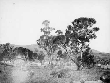 Stawell Historical Society Inc
Photograph, Pleasant Creek Cemetery 1866
... Tree Hill’ where burials were made as early as 1854... Tree Hill’ where burials were made as early as 1854. A memorial ...Pleasant Creek Cemetery. Part of a collection of Photographs by Mr. O.G. Armstrong as commissioned by the Shire of Stawell for the Inter-colonial and Paris Exhibition in Melbourne in 1866. The site of the Pleasant Creek Cemetery was proclaimed on October the 14th, 1861. Prior to that, a cemetery existed on ‘One Tree Hill’ where burials were made as early as 1854. A memorial is located on the site of the One Tree Hill Cemetery, corner of Griffith and Leslie streets, Stawell West. stawell -
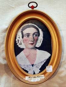 City of Moorabbin Historical Society (Operating the Box Cottage Museum)
Print - Mary Ann Charman 1820 - 1870
Mary Ann Charman was a pioneer settler in the Cheltenham area of the Parish of Moorabbin c1850 Stephen Charman , who emigrated in 1942 as a Henry Dendy employee aged 21 years, sadly lost his wife and child shortly after arriving in Brighton. When Dendy could not employ him he found other work. In 1850 he met Mary Gettens a widow with 5 children who supported her family by managing her late husband’s Inn in Collins St. Melbourne. Stephen purchased land in Spring Grove, now Cheltenham, in 1852 and the family moved to the wattle and daub hut after their marriage. Mary and Stephen worked very hard to establish a market garden, poultry and pork farm . They specialised in Marigolds which they sold to Martin & Pleasance Pharmacy , Melbourne for medicinal purposes. Mary and Stephen had 7 more children and Mary still managed to find time to sell the pork, poultry and vegetables from a horse drawn cart she drove around St Kilda. 1857 Stephen donated land to the Methodist Church for a School, burial ground and Chapel in Balcombe Road. Mary died 1870. Stephen remarried in 1878 and died aged 85 years 1906. Charman Road runs from Nepean Highway , Cheltenham through Beaumaris to the Beach Road at Mentone. Mr Les Jones was the Great Grandson of Mary Ann CharmanAn oval framed colour copy of a painting of the likeness of Mary Ann Charman, 1820 - 1870 pioneer settler in the Cheltenham area of the Parish of Moorabbinpioneers, early settlers, dendy henry, charman mary ann, jones les, cheltenham, moorabbin, brighton, market gardeners, dairy farmers, charman road -
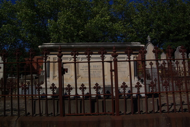 Ballarat Heritage Services
Photograph - Digital photographs, L.J. Gervasoni, Henty Memorial in Boroondara General Cemetery, c2005-2015
The Boroondara General Cemetery is registered by Heritage Victoria. The Henty's were some of the earliest settlers in Victoria.From Heritage Victoria Statement of Significance Last updated on - December 15, 2005 What is significant? Boroondara Cemetery, established in 1858, is within an unusual triangular reserve bounded by High Street, Park Hill Road and Victoria Park, Kew. The caretaker's lodge and administrative office (1860 designed by Charles Vickers, additions, 1866-1899 by Albert Purchas) form a picturesque two-storey brick structure with a slate roof and clock tower. A rotunda or shelter (1890, Albert Purchas) is located in the centre of the cemetery: this has an octagonal hipped roof with fish scale slates and a decorative brick base with a tessellated floor and timber seating. The cemetery is surrounded by a 2.7 metre high ornamental red brick wall (1895-96, Albert Purchas) with some sections of vertical iron palisades between brick pillars. Albert Purchas was a prominent Melbourne architect who was the Secretary of the Melbourne General Cemetery from 1852 to 1907 and Chairman of the Boroondara Cemetery Board of Trustees from 1867 to 1909. He made a significant contribution to the design of the Boroondara Cemetery Boroondara Cemetery is an outstanding example of the Victorian Garden Cemetery movement in Victoria, retaining key elements of the style, despite overdevelopment which has obscured some of the paths and driveways. Elements of the style represented at Boroondara include an ornamental boundary fence, a system of curving paths which are kerbed and follow the site's natural contours, defined views, recreational facilities such as the rotunda, a landscaped park like setting, sectarian divisions for burials, impressive monuments, wrought and cast iron grave surrounds and exotic symbolic plantings. In the 1850s cemeteries were located on the periphery of populated areas because of concerns about diseases like cholera. They were designed to be attractive places for mourners and visitors to walk and contemplate. Typically cemeteries were arranged to keep religions separated and this tended to maintain links to places of origin, reflecting a migrant society. Other developments included cast iron entrance gates, built in 1889 to a design by Albert Purchas; a cemetery shelter or rotunda, built in 1890, which is a replica of one constructed in the Melbourne General Cemetery in the same year; an ornamental brick fence erected in 1896-99(?); the construction and operation of a terminus for a horse tram at the cemetery gates during 1887-1915; and the Springthorpe Memorial built between 1897 and 1907. A brick cremation wall and a memorial rose garden were constructed near the entrance in the mid- twentieth century(c.1955-57) and a mausoleum completed in 2001.The maintenance shed/depot close to High Street was constructed in 1987. The original entrance was altered in 2000 and the original cast iron gates moved to the eastern entrance of the Mausoleum. The Springthorpe Memorial (VHR 522) set at the entrance to the burial ground commemorates Annie Springthorpe, and was erected between 1897 and 1907 by her husband Dr John Springthorpe. It was the work of the sculptor Bertram Mackennal, architect Harold Desbrowe Annear, landscape designer and Director of the Melbourne Bortanic Gardens, W.R. Guilfoyle, with considerable input from Dr Springthorpe The memorial is in the form of a small temple in a primitive Doric style. It was designed by Harold Desbrowe Annear and includes Bertram Mackennal sculptures in Carrara marble. Twelve columns of deep green granite from Scotland support a Harcourt granite superstructure. The roof by Brooks Robinson is a coloured glass dome, which sits within the rectangular form and behind the pediments. The sculptural group raised on a dais, consists of the deceased woman lying on a sarcophagus with an attending angel and mourner. The figure of Grief crouches at the foot of the bier and an angel places a wreath over Annie's head, symbolising the triumph of immortal life over death. The body of the deceased was placed in a vault below. The bronze work is by Marriots of Melbourne. Professor Tucker of the University of Melbourne composed appropriate inscriptions in English and archaic Greek lettering.. The floor is a geometric mosaic and the glass dome roof is of Tiffany style lead lighting in hues of reds and pinks in a radiating pattern. The memorial originally stood in a landscape triangular garden of about one acre near the entrance to the cemetery. However, after Dr Springthorpe's death in 1933 it was found that transactions for the land had not been fully completed so most of it was regained by the cemetery. A sundial and seat remain. The building is almost completely intact. The only alteration has been the removal of a glass canopy over the statuary and missing chains between posts. The Argus (26 March 1933) considered the memorial to be the most beautiful work of its kind in Australia. No comparable buildings are known. The Syme Memorial (1908) is a memorial to David Syme, political economist and publisher of the Melbourne Age newspaper. The Egyptian memorial designed by architect Arthur Peck is one of the most finely designed and executed pieces of monumental design in Melbourne. It has a temple like form with each column having a different capital detail. These support a cornice that curves both inwards and outwards. The tomb also has balustradings set between granite piers which create porch spaces leading to the entrance ways. Two variegated Port Jackson Figs are planted at either end. The Cussen Memorial (VHR 2036) was constructed in 1912-13 by Sir Leo Cussen in memory of his young son Hubert. Sir Leo Finn Bernard Cussen (1859-1933), judge and member of the Victorian Supreme Court in 1906. was buried here. The family memorial is one of the larger and more impressive memorials in the cemetery and is an interesting example of the 1930s Gothic Revival style architecture. It takes the form of a small chapel with carvings, diamond shaped roof tiles and decorated ridge embellishing the exterior. By the 1890s, the Boroondara Cemetery was a popular destination for visitors and locals admiring the beauty of the grounds and the splendid monuments. The edge of suburban settlement had reached the cemetery in the previous decade. Its Victorian garden design with sweeping curved drives, hill top views and high maintenance made it attractive. In its Victorian Garden Cemetery design, Boroondara was following an international trend. The picturesque Romanticism of the Pere la Chaise garden cemetery established in Paris in 1804 provided a prototype for great metropolitan cemeteries such as Kensal Green (1883) and Highgate (1839) in London and the Glasgow Necropolis (1831). Boroondara Cemetery was important in establishing this trend in Australia. The cemetery's beauty peaked with the progressive completion of the spectacular Springthorpe Memorial between 1899 and 1907. From about the turn of the century, the trustees encroached on the original design, having repeatedly failed in attempts to gain more land. The wide plantations around road boundaries, grassy verges around clusters of graves in each denomination, and most of the landscaped surround to the Springthorpe memorial are now gone. Some of the original road and path space were resumed for burial purposes. The post war period saw an increased use of the Cemetery by newer migrant groups. The mid- to late- twentieth century monuments were often placed on the grassed edges of the various sections and encroached on the roadways as the cemetery had reached the potential foreseen by its design. These were well tended in comparison with Victorian monuments which have generally been left to fall into a state of neglect. The Boroondara Cemetery features many plants, mostly conifers and shrubs of funerary symbolism, which line the boundaries, road and pathways, and frame the cemetery monuments or are planted on graves. The major plantings include an impressive row of Bhutan Cypress (Cupressus torulosa), interplanted with Sweet Pittosporum (Pittosporum undulatum), and a few Pittosporum crassifolium, along the High Street and Parkhill Street, where the planting is dominated by Sweet Pittosporum. Planting within the cemetery includes rows and specimen trees of Bhutan Cypress and Italian Cypress (Cupressus sempervirens), including a row with alternate plantings of both species. The planting includes an unusual "squat" form of an Italian Cypress. More of these trees probably lined the cemetery roads and paths. Also dominating the cemetery landscape near the Rotunda is a stand of 3 Canary Island Pines (Pinus canariensis), a Bunya Bunya Pine (Araucaria bidwillii) and a Weeping Elm (Ulmus glabra 'Camperdownii') Amongst the planting are the following notable conifers: a towering Bunya Bunya Pine (Araucaria bidwillii), a Coast Redwood (Sequoia sempervirens), a rare Golden Funeral Cypress (Chamaecyparis funebris 'Aurea'), two large Funeral Cypress (Chamaecyparis funebris), and the only known Queensland Kauri (Agathis robusta) in a cemetery in Victoria. The Cemetery records, including historical plans of the cemetery from 1859, are held by the administration and their retention enhances the historical significance of the Cemetery. How is it significant? Boroondara Cemetery is of aesthetic, architectural, scientific (botanical) and historical significance to the State of Victoria. Why is it significant? The Boroondara Cemetery is of historical and aesthetic significance as an outstanding example of a Victorian garden cemetery. The Boroondara Cemetery is of historical significance as a record of Victorian life from the 1850s, and the early settlement of Kew. It is also significant for its ability to demonstrate, through the design and location of the cemetery, attitudes towards burial, health concerns and the importance placed on religion, at the time of its establishment. The Boroondara Cemetery is of architectural significance for the design of the gatehouse or sexton's lodge and cemetery office (built in stages from 1860 to 1899), the ornamental brick perimeter fence and elegant cemetery shelter to the design of prominent Melbourne architects, Charles Vickers (for the original 1860 cottage) and Albert Purchas, cemetery architect and secretary from 1864 to his death in 1907. The Boroondara Cemetery has considerable aesthetic significance which is principally derived from its tranquil, picturesque setting; its impressive memorials and monuments; its landmark features such as the prominent clocktower of the sexton's lodge and office, the mature exotic plantings, the decorative brick fence and the entrance gates; its defined views; and its curving paths. The Springthorpe Memorial (VHR 522), the Syme Memorial and the Cussen Memorial (VHR 2036), all contained within the Boroondara Cemetery, are of aesthetic and architectural significance for their creative and artistic achievement. The Boroondara Cemetery is of scientific (botanical) significance for its collection of rare mature exotic plantings. The Golden Funeral Cypress, (Chamaecyparis funebris 'Aurea') is the only known example in Victoria. The Boroondara Cemetery is of historical significance for the graves, monuments and epitaphs of a number of individuals whose activities have played a major part in Australia's history. They include the Henty family, artists Louis Buvelot and Charles Nuttall, businessmen John Halfey and publisher David Syme, artist and diarist Georgiana McCrae, actress Nellie Stewart and architect and designer of the Boroondara and Melbourne General Cemeteries, Albert Purchas.Digital imagescemetery, boroondara, kew, gatehouse, clock, tower, clocktower, heritage, memorial, henty, james henty -
 Lakes Entrance Historical Society
Photograph - Bumberrah Cemetery, Johnsonville Victoria, M Holding, George and Sarah Grant headstone, 2010 c
Also buried in the grave is Mrs Alice Stocks buried 1955. This fact verified by family members who attended including grand daughter Bette Archer of Maffra. Funeral director mistakingly recorded the burial at BairnsdaleColour photograph of headstone on graves of George and Sarah Grant early settlers of Metung in the Bumberrah Cemetery near Johnsonville Victoriacemeteries, memorials, settlers -
 Federation University Historical Collection
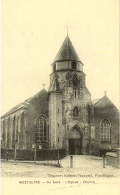
Postcard - black and white, Westoutre Church, France, c1917
Westouter Churchyard and Extension is located 12 Kms south-west of Ieper town centre, on a road leading from the N375 Dikkebusseweg. The village of Westoutre (now Westouter) remained in Allied hands from the early months of the First World War to the Armistice, but in the summer of 1918, after the Battles of the Lys, it was within 2.4 Kms of the front line. The Churchyard and Extension was used by field ambulances and fighting units at intervals from November 1914 to September 1918. It contains 98 Commonwealth burials of the First World War and three German graves.(http://www.ww1cemeteries.com/ww1cemeteries/westouterchurchyardandextension.htm, accessed 11/07/2014) The only Australian buried at the Westoutre churchyard and extension is Gunner J. GRANT (2420) 30/09/1917 Australian Heavy Artillery Australian II. F. 12. (http://www.ww1cemeteries.com/ww1cemeteries/westouterchurchyardandextension.htm, accessed 11/07/2014)A WW1 Australian soldier's memorabiliaBlack and white postcard of a church at WestoutreUitgever: Sansen-Vannest, Poperinghe Westoutre - De Kerk - L'Eglise - Churchwestoutre, westouter, chatham-holmes family collection, france, church -
 Bendigo Historical Society Inc.
Photograph - Rocky Vale Villa, April 2016
The Beebe name was well-known in Bendigo in the last quarter of the 19th and the early part of the 20th centuries. From 1875, William Beebe senior, monumental mason, occupied a site in the centre on the city, in Mitchell Street opposite King Street. Death was more part of life in those days, and the Beebes were there to provide the burial monuments. Later, he took his sons into the business, which grew as Beebe and Son. Many examples of their work can be found in the local cemeteries. William Beebe senior (1830-1891) was born in Rutland, the smallest English county in 1830, to stonemason Chamberlain Beebe and Susannah Clements. William emigrated to Victoria in 1854 and after engaging on unknown works in Port Fairy, Dunkeld, and Melbourne arrived in Bendigo. His obituary records that he commenced work here on the site of the Bank of Australasia (opposite the Shamrock Hotel), which would have been no later than 1856. He took up a 13 acre selection on the site of Rocky Vale Villa in 1864 and continued to select or purchase further parcels of adjoining land until he owned some 150 acres, much of it unfit for cultivation. He was a keen gardener and had a garden and orchard around the house. William took over 20 years to build the two-story sandstone and granite house "Rocky Vale Villa". The house was constructed from sandstone sourced "from an adjacent ridge of rocks" (Bendigo Advertiser 28/9/1891). Granite from Harcourt was used for lintels and quoins. Not long before he died, William was still adding to the house. In the Codicil to his will, he states that "I have just built and completed two additional rooms to my Dwelling house situe at Inglewood Road aforesaid" (dated 19/9/1891). William died one week later on the 26th September 1891.Photographs of a field trip to Rocky Vale Villa, 7 Wicks Road, Maiden Gully, Bendigo by the Bendigo Historical Society.history, bendigo, rocky vale villa maiden gully, william beebe stonemason bendigo -
 Dandenong & District Historical Society
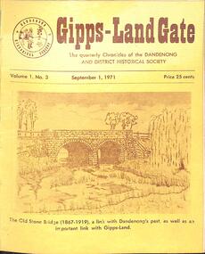
Journal, Dandenong & District Historical Society, Gipps-Land Gate Vol.1 No.3, 1971
An interesting group of Early Dandenong Personalities and eventsA5 size publication of the Gipps-Land Gate, September 1971. 20 pages, featuring a drawing of The Old Stone Bridge (1867-1919) on the cover. Birds-eye View of Dandenong Show On The Clow St. Ground Before The Move To Greaves Reserve Few Changes In Office Bearers Change in Membership Fees To Mark a Vanished Settlement Intriguiging Early Plans Displayed Just For The Record Old Burial Ground Located We Mourn Them Did You Know? The Dandenong Show Committee's First 100 Years Keeping Posted Interesting Milestones Turning Back The Pages 75 Years The Native Police Corps Dandenong Flashback Market A Distinguishing Feature An interesting group of Early Dandenong Personalities and eventshotel history, early education in dandenong, interesting milestones