Showing 179 items
matching east orchard
-
 Eltham District Historical Society Inc
Photograph, Liz Pidgeon, Heritage Excursion; East of Eltham, 6 Sep 2014, 20 May 2017
Newsletter No. 218, September 2014 September Excursion - East of Eltham Walk In Newsletter No. 197, March 2011, there was a brief history of Crown Allotment 15 Section 5 Parish of Nillumbik (CA 15) a parcel of land of a quarter of a square mile extending from Eucalyptus Road to Reynolds Road at the eastern extremity of Eltham. From the 1940s it was known as Stokes orchard. In later years it has been subdivided for residential purposes but leaving significant areas as power line and water supply reserves and bushland reserves that are habitat for the threatened For our excursion on 6th September we intend to walk through CA 15 to a bushland reserve east of Reynolds Road. The walk will traverse the boundary between suburban Eltham and the non-urban areas to the south and east. This is a pleasant walk through residential areas and bushland. Along the way we will discuss the early and more recent history of CA 15 as well as local natural history and geology. This walk is about 3.5 km in length and will take 2 to 2.5 hours. It will start at 2pm at the corner of Eucalyptus Road, Pitt Street and Nyora Road.Born Digitaleltham east, eltham district historical society, heritage excursion, activities, nyora road, reynolds road, gum tree road reserve, diosma road, stokes orchard, eucalyptus road -
 Eltham District Historical Society Inc
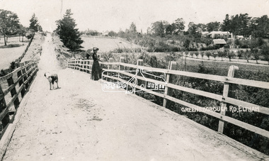
Photograph, Bridge over the Diamond Creek, Greensborough Road, Eltham, c.1885
Original (1874) bridge in Bridge Street, Eltham looking east over the Diamond Creek towards Maria Street (Main Road) at Little Eltham. In the distance to the right on Maria Street is the Methodist Church (1881), now Uniting Church, and the adjacent Commercial Bank of Australia branch building (1878). Part of a slide show presentation "Bridges & Waterways of the Shire" by Russell Yeoman to the 13 September 1989 Society meeting. The presentation included slides of historic photos from the Shire of Eltham Pioneers collections as well as several recent views.Photo of original 1875 timber and gravel surface bridge over the Diamon Creek in Bridge Street with views of orchards representative of the farming lands as well as the development along the northern end of Maria Street.Black and white photograph copybridge street, bridge street bridge, cba bank, diamond creek (creek), eltham, little eltham, main road, maria street, methodist church, uniting church -
 Ringwood and District Historical Society
Letter, Letter written by H.C.Howship to Ringwood Mail Ringwood 1963
To the Editor of the Ringwood Mail Dear Sir, would you please publish in your widely read paper the following letter for the information of the residents of the City of Ringwood- Re the passing of my brother Mr. J.P. Howship, who was an ANZAC one of the pioneer family of Howship of Ringwood which name is connected with the early history of Ringwood or more particularly Ringwood East as the late J.P. Howship and myself purchased the Nursery of Mr. John Hill around the year 1912 and after a couple of years my late brother Bert was taken into partnership and we bought the adjoining nursery of Mr. Will Hill and traded under name Howship Bros. Rosedale Nursery and the name of one street in the old property Howship Avenue is named after the old firm as well as Rosedale Crescent. The move for the establishment of the Ringwood East station started with myself and in a meeting up with a Mr .T. Birkitt who I felt was the man I needed as he was a sub Estate Agent .A meeting was called and held in our packing shed at the end of Federal Road which at that time ended at Mr. Charlie Burdens property and abbuted (sic) on our property. This meeting was attended by about sixty residents and the late Mr. C. Wedge was elected as the first President of the Ringwood East Railway League and Progress Assoc. with Mr. T. Birkitt as Secretary and myself as assist. Secretary. This League raised the sum of about 1,600 from residents and land owners for the erection of the Ringwood East Railway Station & after the station was erected and paid for the League part was canceled and the Progress Assoc. carried on. The present Ringwood East Cricket Club was formed at meeting and the Prog .......and my three brothers Bert, Mervyn and played cricket in the Ringwood district for many years and most of us were members of the Ringwood at first and then the Ringwood East Football clubs and followed the teams for years a few names of the old players came to mind in E. Thomas , C. Weil, T. Homewood, the Pratt family and others. I might mention for the benefit of the City of Ringwood residents my eldest brother Laurie late of New Street and now living at Blairgowrie was with what was then known as Coopers Mills and designed and helped to build some of the first buildings in that property now known as Ringwood Timber & Trading Co .Also that myself and others namely the Reidy Brothers, Mr. Taylor, & L .Cleary & voluntary labour formed the tennis courts at East Ringwood with the help of our young Ladies of the time, those courts I'm pleased to say are well established and two more are added and provide good activities for the young people of the district. Also with the aid of C .Thomas, Norm Blood and others we formed the Methodist courts. From the Ringwood East Progress Association came the move to have a Health Centre for Ringwood. This was established by a good deal of enthusiastic work by some mothers after spending nearly fifty years in Ringwood watching it grow from town surrounded by orchards to a City and I must congratulate the Civic Fathers and their staff in the growth of Ringwood and the fine roads, Parks, Elderly Citizens Club and have all done a good job but why oh why have you neglected mines Road Ringwood east. Why has this road not been made the drainage there is something to be seen to be believed in such a city .The only solution is making and curbing this road & I would ask those responsible why the curbing was put down Dublin Road where there are no residents this curbing could well have solved the problem in Mines Road if used there. I recently spent a weekend with my Daughter, Mrs. Munro at the corner of Maroondah highway and Mines Road and was disgusted at the condition of Mines Road and drainage and had to air my views and suggest a trip to Mines Road by the Civic Fathers led by the Health Inspector I am yours sincerely H.C. Howship Sheila Street, Rye. (copied here verbatim)3 pages of hand written letter detailing the early history of the East Ringwood Railway and Progress Association, football, cricket and tennis clubs.. Written as a draft in 1963.