Showing 244 items matching "eltham market"
-
 Eltham District Historical Society Inc
Photograph - Digital Photograph, Alan King, Eltham Living and Learning Centre, 26 January 2008
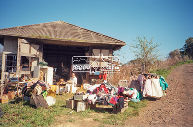
... and a large workshop. From 1979 the Eltham Art and Craft Market... and a large workshop. From 1979 the Eltham Art and Craft Market ...In 1857, tanner John Pearson purchased three and a half acres of land in Little Eltham, at the western end of Pitt Street, with a 70-foot frontage to Maria Street (Main Road) and stretching down to the Diamond Creek for £100. He contracted Benjamin Oliver Wallis to build house for him. Wallis, a mason by trade who originated from the Cornish village of Newlyn, migrated to Melbourne in 1853 and was shortly engaged by Richard Warren to build the Eltham Hotel, which opened in 1854. When Warren fell into financial difficulty in 1858, Wallis purchased the hotel. That same year, Pearson constructed a tannery below the house with access to the water in the Diamond Creek. When Pearson became bankrupt in 1867, Wallis similarly acquired the house from Pearson’s creditors in 1868 and lived there until his death in 1896. For some of this time the house was in the name of Wallis’s son Richard but following his death in 1888, ownership reverted to his father. It was purchased by retired teacher Richard Gilsenen in 1899. Gilsenen was made acting head teacher at the Eltham State School in 1906 following the sudden death of head teacher John Brown. In the 1950s the house was bought by retired engineer Dr Alfred Fitzpatrick and his wife Claire who made various modifications to house goats and poultry as well as structural modifications to the house. In the early 1970s, Eltham Shire Councillors Frank Maas and Don Maling proposed an extended communities’ activities program be set up and the Commonwealth Grants Commission was approached for financial assistance. In 1974 a $50,000 Commonwealth Grant was received by the Shire Council to acquire the Fitzpatrick property as part of the planning to establish an extended communities’ activities program. The Fitzpatricks moved next door and Claire taught at the new Living and Learning Centre, which began in 1975, one of the first community education centres in Victoria. Covered under Heritage Overlay, Nillumbik Planning Scheme. Published: Nillumbik Now and Then / Marguerite Marshall 2008; photographs Alan King with Marguerite Marshall.; p59 It’s a centre for sharing knowledge and friendship and it stands on the former hub of Eltham’s original township near Pitt Street. The Eltham Living and Learning Centre, with around 2000 participants a year, began in 1975 as one of the first Community Education Centres in Victoria. Classes ranging from macramé to wine making to environmental living have enriched the lives of thousands of people through the generosity of tutors sharing their skills free of charge. The centre’s heart is the brick cottage, built in 1858 by tanner John Pearson. He bought the three and a half acre (1.4ha) allotment fronting Maria Street (now Main Road) and stretching down to the Diamond Creek. The allotment formed part of a 316 acre (127.8ha) subdivision, owned by Josiah Holloway, called Little Eltham, north of the original Eltham Reserve.1 The allotment then passed through the hands of several speculators before it was sold to Pearson for £100 in 1857. Mr Pearson’s children attended the Eltham Primary School from 1864 to 1867. But creditors took possession of the property when his tannery folded in 1867. It was then sold to publican Benjamin Wallis, who owned the Eltham Hotel at the corner of Pitt Street and Main Road. In 1899 the property was bought by Richard Gilsenan, who became acting head teacher of the Eltham Primary State School in 1906. In the 1950s, retired engineer Dr Alfred Fitzpatrick and his wife Claire bought the property, and made structural changes. Claire, a journalist and community campaigner, modified and built pens for goats and poultry, a stable, a garage and planted fruit trees and a vegetable garden. In the early 1970s a young woman called Carina Hack approached Gwen Wesson at the Diamond Valley Learning Centre (Victoria’s first Community Education Centre) about starting a community centre. Following Wesson’s suggestion, Hack spoke to Shire President Alistair Knox ‘one bleak rainy afternoon, sipping hot drinks and discussing life’.2 Eltham Shire Councillors Frank Maas and Don Maling proposed a community activities program and the council received a $50,000 Commonwealth Government Grant for this venture.3 The Fitzpatricks sold their property to the council and moved next door and Claire taught at the new centre, which Hack named. Eltham obviously wanted such a centre as Hack recalls. ‘During the next two months we had about 50 volunteers working day, night and weekends, scrubbing down, plastering and painting walls, replacing floors, repairing fences, recycling furniture, sewing curtains and cushions, donating furniture, toys, equipment, clean-ing and gardening…’4 The first enrolment day saw a queue stretching up the driveway nearly to the gate and the first sessions attracted 270 people a week. Soon the outbuildings were converted into pottery studios and a large workshop. From 1979 the Eltham Art and Craft Market was held in the centre’s grounds and the Friends of the Centre ran it from 1980. A former program coordinator, Margaret Johnson, remembers enrolment day in the late 1970s and 1980s, when hundreds of people would queue – and some even camped overnight! Overnighters were greeted in the morning with fresh tea and toast. Another tradition was The Enrolment Day Cake with Recipe, given to volunteers. ‘One happy Enrolment Day fell on February 14 and let’s just say that St Valentine found some willing participants, paying $2 for a kiss.’5 Meanwhile the participants’ children could play at the Council Eltham Lower Park house in Hohnes Road, later in Susan Street. But the centre has had difficulties too. In 1990 a fire destroyed the stable and the police suspected arson. However the pavilion was built in its place.This collection of almost 130 photos about places and people within the Shire of Nillumbik, an urban and rural municipality in Melbourne's north, contributes to an understanding of the history of the Shire. Published in 2008 immediately prior to the Black Saturday bushfires of February 7, 2009, it documents sites that were impacted, and in some cases destroyed by the fires. It includes photographs taken especially for the publication, creating a unique time capsule representing the Shire in the early 21st century. It remains the most recent comprehenesive publication devoted to the Shire's history connecting local residents to the past. nillumbik now and then (marshall-king) collection, benjamin oliver wallis, claire fitzpatrick, don maling, dr alfred fitzpatrick, eltham living and learning centre, frank maas, john pearson, richard gilsenen, tannery -
 Eltham District Historical Society Inc
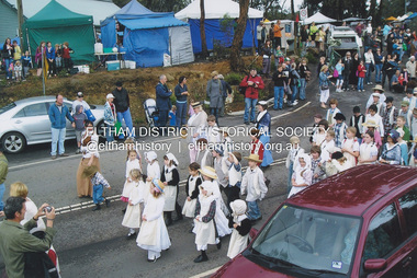
Photograph, Fay Bridge, St Andrews Primary School children in old time costumes, n.d
fay bridge collection, parade, st andrews, st andrews market, st andrews primary school -
 Eltham District Historical Society Inc
Photograph, Fay Bridge, St Andrews Market, Proctor Street, St Andrews, n.d
fay bridge collection, proctor street, st andrews, st andrews market -
 Eltham District Historical Society Inc
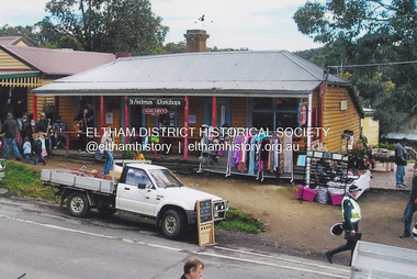
Photograph, Fay Bridge, St Andrews Workshops, Burns Street, St Andrews, n.d
fay bridge collection, proctor street, st andrews, st andrews market, st andrews workshops, burns street, st andrews hotel -
 Eltham District Historical Society Inc
Document - Sales Brochure, Dallas Price Homes Pty Ltd, Eltham Hub: A Unique New Entry To Eltham's Town Centre; the facts about this multi purpose development, 1996
Produced by Contour Consultants Australia Pty Ltd on behalf of Dallas Price Homes Pty Ltd as part of the planning process for redevelopment of the former Eltham Shire Office site at 895 Main Road. In 1963 the Shire of Eltham purchased the Shillinglaw property of approximately 2 acres in Main Road, Eltham for the widening of Main Road and as a site for new Council offices. This land, which contained the Shillinglaw Cottage (c1878-80), was the remaining section of the Shillinglaw family holding that originally comprised 30 acres, being Lot 90 of Holloway's 1851 subdivision. Eltham Council intended to demolish this cottage, but through extensive community action it was saved, funds were raised, and it was relocated to the current site adjacent to the Eltham Library. The new Eltham Shire Offices opened in 1965 were designed to ensure retention of the three Italian Cypress trees that were located outside the Shillinglaw Cottage. In 1971 the building was extended at the southern end to provide additional space, including for the Eltham Library and Council's Engineering Department. Renovations were undertaken to the offices during 1987. The Victorian State Government commenced to restructure local government in 1994, which resulted in the establishment of the Shire of Nillumbik and the cessation of the Shire of Eltham. This new Nillumbik Shire Council was headed by government appointed commissioners, who decided in 1995 to put the former Eltham Shire offices on the market. Eventually in June 1996 the property was sold for $1.1 million and the building was subsequently demolished. A planning application for the site was then submitted to Nillumbik Shire Council in September 1996 for construction of a 24-hour service station, convenience store, cafe/takeaway food premises, a retail facility and community facility. There were many objections to this proposed development and in controversial circumstances a planning permit was granted by the Nillumbik Shire Council commissioners. After protracted actions involving a planning panel and a planning advisory committee, established by the Minister for Local Government, the proposal was eventually rejected as not satisfying the requirements of the planning scheme. In December 1997 the purchaser withdrew from the contract of sale, just prior to Council announcing a withdrawal from the contract. While there have been a number of possible development proposals considered by subsequent Nillumbik Shire Councils, this site has remained vacant since July 1996. TIMELINE (Prepared by Jim Connor, Eltham District Historical Society- March 2018- Based on press, council and personal records) June 1996 - Eltham Shire offices sold to Dallas Price Homes for $1.1 million. July 1996 - Shire office building demolished against community's wishes. Council claimed building riddled with asbestos. September 1996 - Planning application submitted to Nillumbik Shire Council to construct on the site a 24 hours Shell service station, convenience store, Hungry Jacks café/takeaway food premises, a retail facility and community facility. 213 objections and petition of over 1400 signatures received. Minister for Planning and Local Government orders an independent investigation into valuation and sale. 9 October 1996 - Permit granted by Nillumbik Shire Council commissioners, in controversial circumstances. A Planning Special Committee consisting of 3 commissioners and 3 community representatives considered 32 community objections. One commissioner declared a potential conflict of interest so only 2 commissioners were able to vote. After hearing all objections, the community representatives moved a foreshadowed motion to refuse a permit. The commissioners then closed the meeting, formerly opened a council meeting (for about a minute) and approved the application. October 1996 - Community members appealed planning decision to Administrative Appeals Tribunal. November 1996 -Minister for Planning and Local Government Robert McClelland calls appeal in and directs MT to refer this 'major policy issue' to the Governor in Council. February 1997 - Planning panel (Dimity Reed and Margaret Pitt) established to consider submissions. March 1997 - New council elected with five councillors. April 1997 - Three of the five new councillors vote to fight Commissioner's decision to grant a permit. April 1997 - Planning panel (Dimity Reed and Margaret Pitt) conducts hearings at Nillumbik Shire offices. June 1997 -Planning panel rejected Dallas Price Homes proposal as being 'totally inappropriate' for the site and recommends the site be rezoned for 'public purposes'. July 1997 - Dallas Price Homes threatened to sue Council and individual councillors. October 1997 - Report released of an Advisory Committee (Paul Jerome) established by the Minister for Planning and Local Government. Committee considered Dallas Price Homes proposal and an alternative concept plan proposal by Council for a gallery, workshop, offices and cinema community-based development. Advisory Committee recommended Dallas Price Homes proposal be rejected as not satisfying the requirements of the planning scheme and recommended further testing of the financial viability of Council's proposal. December 1997 - Dallas Price Homes withdrew from the contract of sale, just prior to Council announcing a withdrawal from the contract, which expired on 28th November and was not renewed by either side, after previously being extended twice pending a decision by the Minister. Council had to pay developer $58,000 for demolition costs. February 1998 - Dallas Price Homes application rejected by Planning and Local Government Minister. October 1998 - Nillumbik Councillors suspended and an Administrator appointed (until March 1999). The demolition of the former Shire of Eltham offices and proposed sale and development driven by the Commissioners for Nillumbik Shire Council brought the community together in substantial protest at the infrigement of ratepayers democratic say in local government and ciommunity assets combined with protests about inappropraite development of Eltham's Gateway. This issue led to the formation of the Eltham Community Action Group which still operates strongly today (2023) on behalf of the community to ensure appropriate development within the community.895 main road, commissioners, dallas price homes, development application, eltham hub, hungry jacks, nillumbik shire council, re-zoning, shell service station, town planning, eltham gateway, eltham gateway action group, eltham shire offices, shillinglaw cottage, shillinglaw farm, shillinglaw trees, jim connor collection -
 Eltham District Historical Society Inc
Document - Property Binder, Eltham Town Square, Commercial Place, Eltham
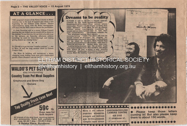
1. Dreams to be reality, The Valley Voice, 15 August 1979, p2 - announcement of proposed town square of 1800 square metres of shop area and open courtyard to be sited in the carpark between Arthur Street and Pryor street. The plans also included tree-lined walkways from both Arthur Street and a pededstrian footbridge across Main Road leading to aregular open-air market and tavern. Shop owners facing Main Road were to be encouraged to turn their businesses towards the square. On reverse side - 'General' Marshall and his troops; Valley votes in five new faces, The Valley Voice, 15 August 1979, p1 - picture showing newly elected Cr Robert Marshall 2. Square plan on display, Diamond Valley News, Tuesday, June 23, 1981, p1 - Council's prefered proposal on display to the public. On same page a story about the son of Cr Bob Manuell being attacked on the train from the city. On reverse side - Helping people - here and abroad by Marguerite Marshall, Diamond Valley News, Tuesday, June 23, 1981, p2 - about Keith Ryall of Zig Zag Road, the Apex international councillor for Australia 3. Plan: Eltham Town Centre property Acquisition, Shire of Eltham March 1994businesses, arthur street, bible street, commercial place, dudley street, eltham, franklins supermarket, luck street, main road, map, mcewans, pryor street, safeway supermarket, apex club, bronwyn ryall, keith ryall, zig zag road, cr bob manuell, cr robert allen, det sgt noel murphy, eltham chamber of commerce, eltham police, eltham shire council, eltham town square, lorraine manuell, pauline toner mp, robert manuell, rodney roscholler, shire planner, vicrail, elections, h&j white general store, hurstbridge, leslie bowker, main street, mrs marshall, pam lawson, robert marshall, rosemary tovey, central park, comfort station, eltham little theatre, montmorency, public toilets, rotex cinema, were street -
 Eltham District Historical Society Inc
Document - Folder, McColl, Stan, Dorothy and Marj
... Waterfall's market garden Eltham... McColl) Waterfall's market garden Eltham Lindsay McColl Eddie ...Siblings Stan McColl, Dorothy Thomson and Marj Johnstone remember their childhood in Eltham. Contents Newspaper article: "Sweet thoughts of youth recaptured" Diamond Valley News, 26 August 1986, outlines the Eltham childhood of the McColl siblings.Newspaper clippings, A4 photocopies, etcstan mccoll, dorothy thomson (nee mccoll), marj johnstone (nee mccoll), waterfall's market garden eltham, lindsay mccoll, eddie mccoll, jack logan, corroborrees in eltham, eltham shire hall, kevin fry, goldmine in diamond creek, st margaret's church eltham, henry street hall eltham -
 Eltham District Historical Society Inc
Journal, Peter Doughtery, ArtStreams: Vol. 10, No. 2, 2005
Vol. 10, No. 2, May-Jun 2005 CONTENTS Richmond 3121 - the book 2 Daryl Braithwaite rocks up at Wellers 5 Shelton Lea lauded and farewelled 8 Artin' About 10 Wining & Dining 14 Listings 16"Peter Dougherty has been involved in the local art scene for many years. As publisher and editor of the arts magazine Artstreams, his comments on the various branches of the arts are widely respected. His "The Arts" column in the Diamond Valley Leader presents a brief summary for a much wider cross section of the local community. Peter also operates his own gallery and the Artstreams Cafe at the St Andrews market. Peter has a wealth of knowledge about present day and historical aspects of local art and artists." - Eltham District Historical Society Newsletter No. 161, March 2005Colour front and back cover with feature articles and literary pieces with photographs and advertisements printed in black and white. 16 pages, 30 cm. Vol. 1, no. 1 (Nov. 1996) - Vol. 10, no. 5 (summer ed. 2005/06) art streams, art streams magazine, daryl braithwaite, wellers, richmond 3121, daniel moynihan, anthony figallo, shelton lea -
 Eltham District Historical Society Inc
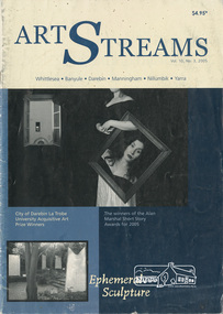
Journal, Peter Doughtery, ArtStreams: Vol. 10, No. 3, 2005
Vol. 10, No. 3, Jul-Aug 2005 CONTENTS Alan Marshall Short Story Award Winner 2 Ephemeral Sculpture 7 Food and a Question of Time - John Jenkins 10 Rhythm of the Land & Sea - Julie Tippene O'Toole 11 Silver Stars: A Mongolian Story - Lisa Edwards and Jenny Grinlington 12 Darebin La Trobe Art Prize 15 Jill Kahans mixes her media 17 Poetry 18 CD Reviews 19 Jack Henseleit - The Legend of Neil Douglas 20 Artin' About 21 Wining & Dining 26 Listings 28"Peter Dougherty has been involved in the local art scene for many years. As publisher and editor of the arts magazine Artstreams, his comments on the various branches of the arts are widely respected. His "The Arts" column in the Diamond Valley Leader presents a brief summary for a much wider cross section of the local community. Peter also operates his own gallery and the Artstreams Cafe at the St Andrews market. Peter has a wealth of knowledge about present day and historical aspects of local art and artists." - Eltham District Historical Society Newsletter No. 161, March 2005Colour front and back cover with feature articles and literary pieces with photographs and advertisements printed in black and white. 28 pages, 30 cm. Vol. 1, no. 1 (Nov. 1996) - Vol. 10, no. 5 (summer ed. 2005/06) art streams, art streams magazine, ephemeral sculptures, alan marshall short story award, click here to add keywords, darebin la trobe art prize, ephemeral sculpture, jack henseleit, jenny grinlington, jill kahans, john jenkins, julie tippene o'toole, lisa edwards, neil douglas, rhythm of the land & sea -
 Eltham District Historical Society Inc
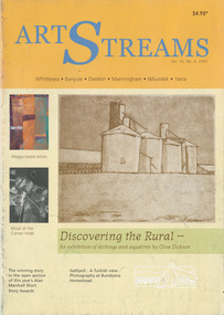
Journal, Peter Doughtery, ArtStreams: Vol. 10, No. 4, 2005
Vol. 10, No. 4, Sep-Oct 2005 CONTENTS Short story In Shadows by Bill Collopy 3 Discovery of the rural by Clive Dickson 7 Wagga based artists by Thomas A. Middlemost 10 Short Story by Emilie Anita Teear 12 Gallipoli : A Turkish view Photography at Bundoora Homestead 13 Musicians who answered the call 16 Book reviews 18 Australian landscape Conference 2005 by Kate Herd 20 Threads that bind the CSA and CWA 22 Music at Wellers Restaurant 23 Music reviews 24 The Snakes in Eden by John Jenkins 27 Artin' About 29 Wining & Dining 30 Listings 32"Peter Dougherty has been involved in the local art scene for many years. As publisher and editor of the arts magazine Artstreams, his comments on the various branches of the arts are widely respected. His "The Arts" column in the Diamond Valley Leader presents a brief summary for a much wider cross section of the local community. Peter also operates his own gallery and the Artstreams Cafe at the St Andrews market. Peter has a wealth of knowledge about present day and historical aspects of local art and artists." - Eltham District Historical Society Newsletter No. 161, March 2005Colour front and back cover with feature articles and literary pieces with photographs and advertisements printed in black and white. 32 pages, 30 cm. Vol. 1, no. 1 (Nov. 1996) - Vol. 10, no. 5 (summer ed. 2005/06) art streams, art streams magazine, silos, australian landscape conference 2005, bill collopy, bundoora homestead, click here to add keywords, clive dickson, emilie anita teear, gallipoli, john jenkins, kate herd, the snakes in eden, thomas a. middlemost, wagga based artists -
 Eltham District Historical Society Inc
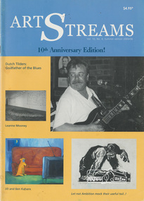
Journal, Peter Doughtery, ArtStreams: Vol. 10, No. 5 Summer Edition 2005-06, 2005
Vol. 10, No. 4, [sic] Summer 2005-06 CONTENTS Alan Marshal Young Writers Short Story Award Winner 3 Winning stories from the William Barak Short Story and Bushcraft competition by Joydyn Chandler and Bethany McGill 4 John Jenkins on Ian McBryde 6 Leanne Mooney 9 Isabelle Clements 10 Poetry 11 Book Reviews 13 CWA meets CSA 15 Social Realists at the Counihan Gallery 16 Ian McBryde Poetry Reviews 19 Music & CD Reviews 20 Artin' About 25 Art Services & Classes 29 Wining & Dining 30"Peter Dougherty has been involved in the local art scene for many years. As publisher and editor of the arts magazine Artstreams, his comments on the various branches of the arts are widely respected. His "The Arts" column in the Diamond Valley Leader presents a brief summary for a much wider cross section of the local community. Peter also operates his own gallery and the Artstreams Cafe at the St Andrews market. Peter has a wealth of knowledge about present day and historical aspects of local art and artists." - Eltham District Historical Society Newsletter No. 161, March 2005Colour front and back cover with feature articles and literary pieces with photographs and advertisements printed in black and white. 32 pages, 30 cm. Vol. 1, no. 1 (Nov. 1996) - Vol. 10, no. 5 (summer ed. 2005/06) 10th Anniversary Edition!art streams, art streams magazine, alan marshal young writers, bethany mcgill, ian mcbryde, isabelle clements, john jenkins, joydyn chandler, leanne mooney -
 Eltham District Historical Society Inc
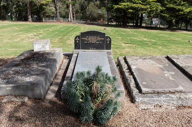
Photograph, Peter Pidgeon, Grave of Guido Quarto Fabbro, Eltham Cemetery, Victoria, 5 April 2021
Guido Quarto Fabbro was born 21 August 1891 at Treppo Grande in the far northeast of Italy, the son of Giacomo Fabbro and Anna Geruzzi. Regina Moretti was born 6 March 1893 at Treppo Grande, Italy, the daughter of Giovanni Battista Moretti and Maria Teresa Coletti. Guido and Regina married about 1917 and they had two sons, Giacomo (John c.1918) and Maurie (c.1920). In 1925 Guido Fabbro departed his homeland from Genoa, arriving in Fremantle, Western Australia in June, travelling 3rd class aboard the ship, Caprera. Regina and their two boys followed a year later along with other family members arriving in Fremantle from Genoa 4 July 1926 aboard the Moncalieri. The Fabbro arrived in Eltham in 1933 and purchased a block of land from William West on the western side of Falkiner Street, extending to Ely and Porter Streets which had formerly been part of the West family orchard and dairy farm. As there was no fencing dividing the two properties, West served notice on Guido in December 1934 to bear half of the cost of £6. When payment was not forthcoming, West sued Guido in the Eltham Court in January 1935. Guido failed to appear and was not represented, and costs were ordered in West’s favour. Guido and Regina built a large Italianesque house on their property. The original 1860s cottage was relocated to the back of the block and was rented out (once to Alistair and Margot Knox). Guido also purchased land extending to the Diamond Creek on the eastern side of Falkiner Street and on the eastern side of Bell Street (opposite Eltham High School). The riparian soil was suitable for market gardening: Guido grew mainly tomatoes, but also pumpkins, cauliflowers, cabbages, peas, beans, lettuce, beetroot and zucchinis. Even the land surrounding the house was used. The produce was carted to Melbourne overnight for sale at the market. Guido died in 1970 and is buried in Eltham cemetery. Regina died 1986. She and their son John Patrick (Giacomo) Fabbro who died in 1984 are also buried at Eltham Cemetery. Guido’s son Maurie continued in his father’s footsteps until 2007, principally growing artichokes in later years. He died in 2009. The land on the eastern side of Falkiner Street now forms part of a Council reserve called “Barak Bushland”, the land on the western side having been sold off for residential subdivision. The Bell Street land is now public open space managed by Nillumbik Shire Council and called “Fabbro Fields”. There have been recent proposals to develop the site for sporting purposes or as a dog park or community garden. In Memory of Guido Quarto Fabbro Beloved husband of Regina Died 15-3-1970 aged 79 R.I.PBorn Digitaleltham cemetery, gravestones, guido quarto fabbro, regina fabbro -
 Eltham District Historical Society Inc
Journal - Newsletter, Nillumbik Shire Council, Nillumbik News, October 2000
Christmas 2001 articles include: Governor of Victoria re-dedicates KG War Memorial Tower Election details (2002) Summer at the Diamond Creek Pool Community Safety Expo Nillumbik Festival of the Arts: ‘art, caught in the act’ 22 Feb to 3 Mar 2002 Neighbourhood Character Study out for comment Plans to revive St Andrews Market site Integrated Transport Strategy seeks less car usage Eltham Festival Album Rural connector roads strategy Rural Collector Roads to be Sealed Roundabout funding for Diamond Creek Community Fireguard helps prepare for fire Planning for bush fire this summer Capital Works projects on track for 2001-2002 Eltham Town Square opens council newsletters, nillumbik news, nillumbik shire council -
 Eltham District Historical Society Inc
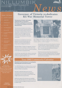
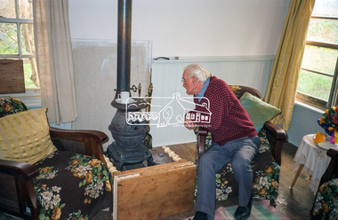
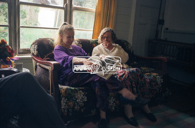
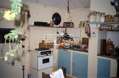
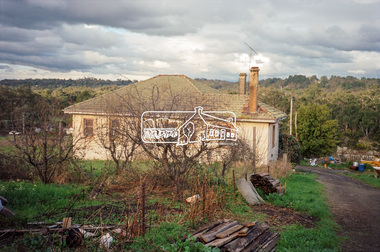
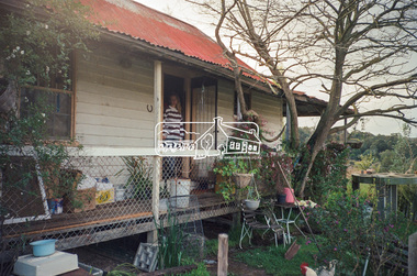
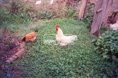
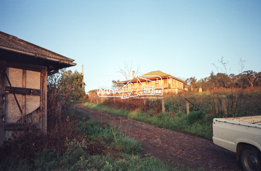
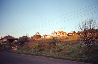
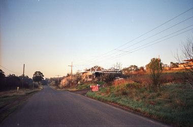
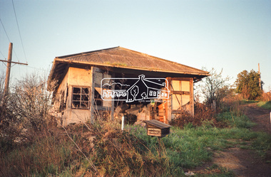
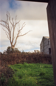
Photograph, Hans Gregory, Original 1860s William West house, Fabbro's Farm, Falkiner Street, Eltham, c.1990
Photos taken by Hans Gregory who along with partner Pauline Steele, rented the original old 1860s William West Cottage situated behind the Fabbro family home. Hans was employed as a Youth officer with the Shire of Eltham at the time and was the last tennant on the property. The property was sold and in 1995 was developed for residential housing as the Riverview Park estate. Guido Quarto Fabbro was born 21 August 1891 at Treppo Grande in the far northeast of Italy, the son of Giacomo Fabbro and Anna Geruzzi. Regina Moretti was born 6 March 1893 at Treppo Grande, Italy, the daughter of Giovanni Battista Moretti and Maria Teresa Coletti. Guido and Regina married about 1917 and they had two sons, Giacomo (John c.1918) and Maurie (c.1920). In 1925 Guido Fabbro departed his homeland from Genoa, arriving in Fremantle, Western Australia in June, travelling 3rd class aboard the ship, Caprera. Regina and their two boys followed a year later along with other family members arriving in Fremantle from Genoa 4 July 1926 aboard the Moncalieri. The Fabbros arrived in Eltham in 1933 and purchased a block of land from William West on the western side of Falkiner Street, extending to Ely and Porter Streets which had formerly been part of the West family orchard and dairy farm. As there was no fencing dividing the two properties, West served notice on Guido in December 1934 to bear half of the cost of £6. When payment was not forthcoming, West sued Guido in the Eltham Court in January 1935. Guido failed to appear and was not represented, and costs were ordered in West’s favour. Guido and Regina built a large Italianesque house on their property. The original 1860s cottage was relocated to the back of the block and was rented out (once to Alistair and Margot Knox). Guido also purchased land extending to the Diamond Creek on the eastern side of Falkiner Street and on the eastern side of Bell Street (opposite Eltham High School). The riparian soil was suitable for market gardening: Guido grew mainly tomatoes, but also pumpkins, cauliflowers, cabbages, peas, beans, lettuce, beetroot and zucchinis. Even the land surrounding the house was used. The produce was carted to Melbourne overnight for sale at the market. Guido died in 1970 and is buried in Eltham cemetery. Regina died 1986. She and their son John Patrick (Giacomo) Fabbro who died in 1984 are also buried at Eltham Cemetery. Guido’s son Maurie continued in his father’s footsteps until 2007, principally growing artichokes in later years. He died in 2009. The land on the eastern side of Falkiner Street now forms part of a Council reserve called “Barak Bushland”, the land on the western side having been sold off for residential subdivision. The Bell Street land is now public open space managed by Nillumbik Shire Council and called “Fabbro Fields”. There have been recent proposals to develop the site for sporting purposes or as a dog park or community garden. Provides an insight into early settler's farmhouses and farming property of the Eltham district.guido quarto fabbro, regina fabbro (nee moretti), william west, maurie fabbro, fabbro's farm, hans gregory, west family orchard, west dairy farm -
 Eltham District Historical Society Inc
Photograph, Hans Gregory, Original 1860s William West house, Fabbro's Farm, Falkiner Street, Eltham, c.1990
Photos taken by Hans Gregory who along with partner Pauline Steele, rented the original old 1860s William West Cottage situated behind the Fabbro family home. Hans was employed as a Youth officer with the Shire of Eltham at the time and was the last tennant on the property. The property was sold and in 1995 was developed for residential housing as the Riverview Park estate. Guido Quarto Fabbro was born 21 August 1891 at Treppo Grande in the far northeast of Italy, the son of Giacomo Fabbro and Anna Geruzzi. Regina Moretti was born 6 March 1893 at Treppo Grande, Italy, the daughter of Giovanni Battista Moretti and Maria Teresa Coletti. Guido and Regina married about 1917 and they had two sons, Giacomo (John c.1918) and Maurie (c.1920). In 1925 Guido Fabbro departed his homeland from Genoa, arriving in Fremantle, Western Australia in June, travelling 3rd class aboard the ship, Caprera. Regina and their two boys followed a year later along with other family members arriving in Fremantle from Genoa 4 July 1926 aboard the Moncalieri. The Fabbros arrived in Eltham in 1933 and purchased a block of land from William West on the western side of Falkiner Street, extending to Ely and Porter Streets which had formerly been part of the West family orchard and dairy farm. As there was no fencing dividing the two properties, West served notice on Guido in December 1934 to bear half of the cost of £6. When payment was not forthcoming, West sued Guido in the Eltham Court in January 1935. Guido failed to appear and was not represented, and costs were ordered in West’s favour. Guido and Regina built a large Italianesque house on their property. The original 1860s cottage was relocated to the back of the block and was rented out (once to Alistair and Margot Knox). Guido also purchased land extending to the Diamond Creek on the eastern side of Falkiner Street and on the eastern side of Bell Street (opposite Eltham High School). The riparian soil was suitable for market gardening: Guido grew mainly tomatoes, but also pumpkins, cauliflowers, cabbages, peas, beans, lettuce, beetroot and zucchinis. Even the land surrounding the house was used. The produce was carted to Melbourne overnight for sale at the market. Guido died in 1970 and is buried in Eltham cemetery. Regina died 1986. She and their son John Patrick (Giacomo) Fabbro who died in 1984 are also buried at Eltham Cemetery. Guido’s son Maurie continued in his father’s footsteps until 2007, principally growing artichokes in later years. He died in 2009. The land on the eastern side of Falkiner Street now forms part of a Council reserve called “Barak Bushland”, the land on the western side having been sold off for residential subdivision. The Bell Street land is now public open space managed by Nillumbik Shire Council and called “Fabbro Fields”. There have been recent proposals to develop the site for sporting purposes or as a dog park or community garden. Provides an insight into early settler's farmhouses and farming property of the Eltham district.guido quarto fabbro, regina fabbro (nee moretti), william west, maurie fabbro, fabbro's farm, hans gregory, west family orchard, west dairy farm -
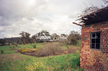 Eltham District Historical Society Inc
Photograph, Hans Gregory, Original 1860s William West house, Fabbro's Farm, Falkiner Street, Eltham, c.1990
Photos taken by Hans Gregory who along with partner Pauline Steele, rented the original old 1860s William West Cottage situated behind the Fabbro family home. Hans was employed as a Youth officer with the Shire of Eltham at the time and was the last tennant on the property. The property was sold and in 1995 was developed for residential housing as the Riverview Park estate. Guido Quarto Fabbro was born 21 August 1891 at Treppo Grande in the far northeast of Italy, the son of Giacomo Fabbro and Anna Geruzzi. Regina Moretti was born 6 March 1893 at Treppo Grande, Italy, the daughter of Giovanni Battista Moretti and Maria Teresa Coletti. Guido and Regina married about 1917 and they had two sons, Giacomo (John c.1918) and Maurie (c.1920). In 1925 Guido Fabbro departed his homeland from Genoa, arriving in Fremantle, Western Australia in June, travelling 3rd class aboard the ship, Caprera. Regina and their two boys followed a year later along with other family members arriving in Fremantle from Genoa 4 July 1926 aboard the Moncalieri. The Fabbros arrived in Eltham in 1933 and purchased a block of land from William West on the western side of Falkiner Street, extending to Ely and Porter Streets which had formerly been part of the West family orchard and dairy farm. As there was no fencing dividing the two properties, West served notice on Guido in December 1934 to bear half of the cost of £6. When payment was not forthcoming, West sued Guido in the Eltham Court in January 1935. Guido failed to appear and was not represented, and costs were ordered in West’s favour. Guido and Regina built a large Italianesque house on their property. The original 1860s cottage was relocated to the back of the block and was rented out (once to Alistair and Margot Knox). Guido also purchased land extending to the Diamond Creek on the eastern side of Falkiner Street and on the eastern side of Bell Street (opposite Eltham High School). The riparian soil was suitable for market gardening: Guido grew mainly tomatoes, but also pumpkins, cauliflowers, cabbages, peas, beans, lettuce, beetroot and zucchinis. Even the land surrounding the house was used. The produce was carted to Melbourne overnight for sale at the market. Guido died in 1970 and is buried in Eltham cemetery. Regina died 1986. She and their son John Patrick (Giacomo) Fabbro who died in 1984 are also buried at Eltham Cemetery. Guido’s son Maurie continued in his father’s footsteps until 2007, principally growing artichokes in later years. He died in 2009. The land on the eastern side of Falkiner Street now forms part of a Council reserve called “Barak Bushland”, the land on the western side having been sold off for residential subdivision. The Bell Street land is now public open space managed by Nillumbik Shire Council and called “Fabbro Fields”. There have been recent proposals to develop the site for sporting purposes or as a dog park or community garden. Provides an insight into early settler's farmhouses and farming property of the Eltham district.guido quarto fabbro, regina fabbro (nee moretti), william west, maurie fabbro, fabbro's farm, hans gregory, west family orchard, west dairy farm