Showing 678 items matching "enlarger"
-
 Yendon History Group
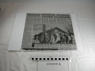
Newspaper Cutting, school, Yendon School Faces Closure, 31/3/1982 (exact); Newspaper published 31 Mar 1982
Photocopy of newspaper article, Ballarat Courier 31 May 1982. Enlarged copy, laminated.yendon state school, yendon public school, ballarat courier, small school closure -
 Yendon History Group
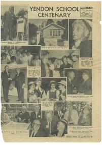
Newspaper Cutting, school, YENDON SCHOOL CENTENARY
Full page (57) of paper, showing 11 photographs of 33 people. Many ex-students attended the unveiling of the commemorative plaque (item 00007)Photocopy of newspaper article, Weekly Times 1st April 1964. enlarged copy, laminated. -
 Clunes Museum
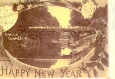
Photograph
ENLARGED PHOTOCOPY - POSTCARD - BRIDGES OVER CLUNES CREEK NOW KNOWN AS CRESWICK CREEK.local history, photography, photographs, bridges -
 Whitehorse Historical Society Inc.
Map, Whitehorse Road, Mitcham, 1972
Enlarged aerial photograph of area around intersection of Whitehorse Road and Heatherdale Roads, Mitcham.Enlarged aerial photograph of area around intersection of Whitehorse Road and Heatherdale Roads, Mitcham.Enlarged aerial photograph of area around intersection of Whitehorse Road and Heatherdale Roads, Mitcham.whitehorse road, mitcham, heatherdale road, mitcham, ringwood, maroondah highway, aerial photographs -
Whitehorse Historical Society Inc.
Map, Burwood Highway, c1970
Enlarged aerial photo of area South of Burwood Highway to Dandenong Creek, Vermont South.Enlarged aerial photo of area South of Burwood Highway to Dandenong Creek, Vermont South.Enlarged aerial photo of area South of Burwood Highway to Dandenong Creek, Vermont South.dandenong creek, morack road, vermont south, burwood highway, vermont south, aerial photographs -
Canterbury History Group
Map - Township of Canterbury and Township of Balwyn, 1900
Copies of the maps of Canterbuy and Balwyn copied and enlarged from Sands and Mcdougall Directory 1900canterbury, balwyn, sands and mcdougall directories -
Stawell Historical Society Inc
Photograph, Soldiers’ Memorial World War 1 in Main Street
Soldiers’ Memorial WW1 erected by "The Stawell Girld Remembrance League" unveiled in 1923.Black & white enlarged photo of Soldiers Memorial WW1. Floral wreaths are on the steps of the memorial. stawell ww1 memorial -
 University of Melbourne, Burnley Campus Archives
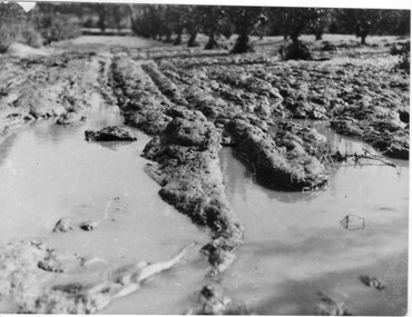
Photograph - Black and white print, Orchard After Flood, 1934
Black and white photograph. Orchard after flood: shows damage to the soil. Enlarged photograph.orchard, yarra river, floods, 1934, soil -
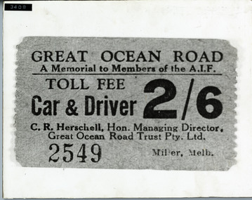 Lorne Historical Society
Photograph, G.O,R. Toll Fee Sign
An enlarged photography showing a Toll Fee Ticket. The toll cost was 2/6d for a car and driver.toll-fee-ticket. g.o.r. -
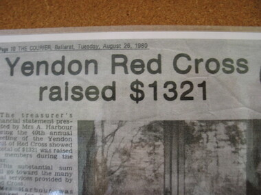 Yendon History Group
Newspaper Cutting, Red Cross, Yendon Red Cross raised $1321, 26/8/1980 (exact)
Photocopy of newspaper article, Ballarat Courier, Tuesday 26 August 1980. Enlarged copy, laminated.yendon, ballarat courier, yendon red cross, community service -
Yendon History Group
Newspaper cutting, railway, Railway ganger retires
Photocopy of newspaper article, The Courier, Ballarat, Saturday Jan 21 1967. enlarged copy, laminated -
Port Melbourne Historical & Preservation Society
Photograph - Prince Alfred Football Club, Port Melbourne, Allan Farrow, 1952
Two copies of photograph of Prince Alfred Football Club, 1952; one greatly enlarged and at B11.05Sunday amateur football league presented to Mr J SCOTT, president Prince Alfred Hotel, Port Melbournesport - australian rules football, prince alfred hotel, l jones, j tims, b bragg, j walsh, h brown, j carol, j tillie, r dobson, p harris, w austin, e colbert, l fraser, j scott, j dobson, r mareslaux, j powell, w leslie, g barclay, k mcmartin, r maloney, j johnson, k clayton, a wood, r callender, l parrish, g mangan, r tinzley -
 Hume City Civic Collection
Photograph
A b/w enlarged photograph of a 2 storey brick residence of 'Ardcloney' the home of Dr. Faulkner.Residence Dr Faulkner - Sunburyfaulkner, - (dr), doctors, houses, sunbury, house names, ardcloney, george evans collection -
 Stawell Historical Society Inc
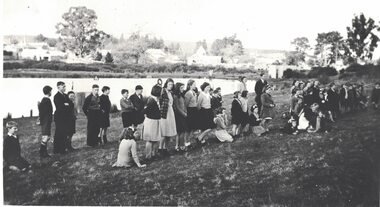
Photograph, Salvation Army Sunday School Picnic 1911 -- 2 Photos
Two Salvation Army Sunday School Picnic photographs showing groups of people in bushland setting. 1911-1912.Two sepia photographs of large groups of people in a bush setting. Also two enlarged copies.Picnic at Stawell 1911 or 12. When Jack & Emma were the Officers at Stawell.stawell religion -
 University of Melbourne, Burnley Campus Archives
Plan, Burnley Gardens 1945, 1945
"Plan of School of Horticulture. Burnley Gardens 1945," handwritten on reverse. Also, photocopy of part of it, enlarged.Plan of School of Horticulture. Burnley Gardens 1945, handwritten on reverse.burnley gardens, burnley school of horticulture -
 University of Melbourne, Burnley Campus Archives
Photograph - Colour print, Garden View, c. 1990
Enlarged colour photograph. Garden view from the Plant Research Laboratory towards the Administration Buildinggarden view, plant research laboratory, administration building -
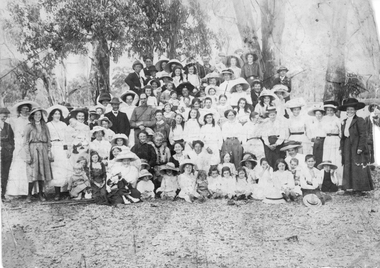
 Linton and District Historical Society Inc
Photograph, Commemorative Tree Planting for Princess Elizabeth
People were gathered for a commemorative tree planting for Princess Elizabeth. Date not known.Enlarged copy of original black and white photograph showing a crowd of people at the Edinburgh Dam in Linton.edinburgh dam, tree planting, princess elizabeth, community events -
Whitehorse Historical Society Inc.
Map, Husband Road, Forest Hill, 1972
Enlarged aerial photo of area between Canterbury and Husband Roads Forest Hill. Melbourne, 1972Enlarged aerial photo of area between Canterbury and Husband Roads Forest Hill. Melbourne, 1972Enlarged aerial photo of area between Canterbury and Husband Roads Forest Hill. Melbourne, 1972canterbury road, forest hill, husband road, forest hill, hylton crescent, forest hill, sapphire street, forest hill, opal street, forest hill, amber street, forest hill, willurah street, forest hill, nunawading swimming pool, aerial photographs, nunawading memorial swimming pool, nunawading pool, aqualink nunawading -
 Ithacan Historical Society
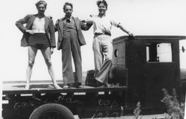
Photograph, At Mornington, 1939
Georgos Petalas, Stathis Raftopoulos and Andreas Lekatsas, posing on the tray of a truck at Mornington,1939.Mornington was a popular destination for beach day trips for many Ithacans.Black & white photograph with white frame on the back of a truck. Appears to be enlarged from smaller photo. Handwritten on photo GEORGE, STAN, PETER/1939 Stamped on back PROPERTY OF/STATHIS RAFTOPOULOS/POET Ithacan Historical Society Inc. is stamped on the back. -
Glenelg Shire Council Cultural Collection
Photograph - Photograph - construction work, 1960
Port of Portland Authority archivesFront: (no inscriptions) Back: equ001 (pencil, lower left) [pencil instructions for enlarging and cropping on back]port of portland archives, construction, quarry, earth moving -
 Flagstaff Hill Maritime Museum and Village
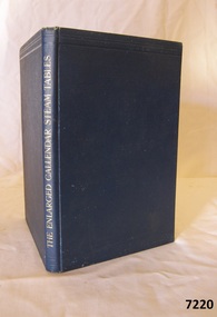
Book, The Enlarged Callendar Steam Tables
The Enlarged Callendar Steam Tables by Callendar, H H Publisher Edward Arnold & Co Date 1924 warrnambool, shipwrecked-coast, flagstaff-hill, flagstaff-hill-maritime-museum, maritime-museum, shipwreck-coast, flagstaff-hill-maritime-village, shipwrecked-artefact, pattison collection, book, the enlarged callendar steam tables, h. h. callendar -
Donald History and Natural History Group operating the Donald Court House Museum
Photograph #50
Enlarged photograph of Georgie watering his vegetables with water containers on both shoulders, in pine frame with glass.#80georgie ah ling, market gardener, donald. -
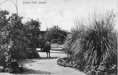 Stawell Historical Society Inc
Photograph, Central Park Gardens c1900, c1900
Central Park Gardens. Boy at center and large grass trees on right. c1900Post card showing a male standing in Central Park Gardens. Also an enlarged copy of the post card.stawell -
Whitehorse Historical Society Inc.
Map, Boronia Road, Canterbury Road intersection, c1970
Enlarged aerial photograph of the intersection of Canterbury and Boronia Roads. State Aerial Survey, Melbourne 1970 project.Enlarged aerial photograph of the intersection of Canterbury and Boronia Roads. State Aerial Survey, Melbourne 1970 project.Enlarged aerial photograph of the intersection of Canterbury and Boronia Roads. State Aerial Survey, Melbourne 1970 project.boronia road, vermont, canterbury road, vermont, mitcham road, vermont, frances avenue, vermont, nurlendi road, vermont, beaumont street, vermont, kingsclere street, vermont, webb court, vermont, aerial photographs -
Whitehorse Historical Society Inc.
Map, Canterbury Road, Vermont, c1970
Enlarged aerial photo of intersection of Canterbury and Boronia Roads. State Aerial Survey, Melbourne 1970 project.Enlarged aerial photo of intersection of Canterbury and Boronia Roads. State Aerial Survey, Melbourne 1970 project.Enlarged aerial photo of intersection of Canterbury and Boronia Roads. State Aerial Survey, Melbourne 1970 project.canterbury road, vermont, boronia road, vermont, mitcham road, vermont, frances avenue, vermont, nurlendi road, vermont, webb court, vermont, vermont primary school, no. 1022, aerial photographs -
Whitehorse Historical Society Inc.
Map, Mitcham Road, c1970
Enlarged aerial photograph of intersection of Whitehorse and Mitcham Roads, Mitcham. Scale 1 inch : 40 feetEnlarged aerial photograph of intersection of Whitehorse and Mitcham Roads, Mitcham. Scale 1 inch : 40 feetEnlarged aerial photograph of intersection of Whitehorse and Mitcham Roads, Mitcham. Scale 1 inch : 40 feetmitcham road, mitcham, maroondah highway, mitcham, whitehorse road, mitcham, mitcham primary school, no. 2904, mitcham hotel, aerial photographs -
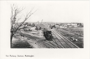 Rutherglen Historical Society
Image, 1938 (Exact)
Black and white postcard showing a photograph of the Rutherglen Railway Station. This one is an enlarged photographic duplicate of 449.9arailway stations, railway yards, trains -
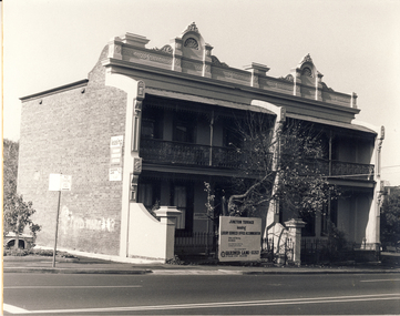 Kew Historical Society Inc
Photograph, Terraces, Princess Street, Kew, c.1980
One of a series of photos created for an exhibition by the City of Kew of notable locations. The photos represent a snapshot in time.Enlarged photograph mounted on board, donated to the Kew Historical Society by the City of Kew on 10 April 1991.houses - kew (vic), princess street - kew (vic) -
 Kew Historical Society Inc
Photograph, City of Kew, Hays Paddock, Kew East, c.1980
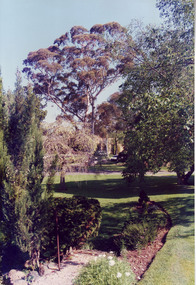
One of a series of photos created for an exhibition by the City of Kew of notable locations. The photos represent a snapshot in time.Enlarged photograph mounted on board, donated to the Kew Historical Society by the City of Kew on 10 April 1991.hays paddock - kew east (vic), kew (vic) - history, kew (vic) - public parks, kew (vic) - farming -
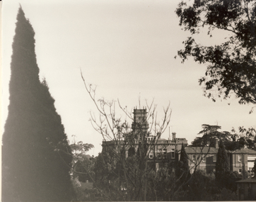 Kew Historical Society Inc
Photograph, City of Kew, 'Raheen', Studley Park Road, Kew, c.1980
One of a series of photos created for an exhibition by the City of Kew of notable locations. The photos represent a snapshot in time.Enlarged photograph mounted on board, donated to the Kew Historical Society by the City of Kew on 10 April 1991.houses - kew (vic), raheen - studley park road - kew (vic)