
Showing 63 items matching "geological map of the world"
-
 The Beechworth Burke Museum
Geological specimen - Coorongite
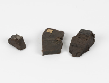
... In 1853-69 the Geological Survey issued under Selwyn's direction sixty-one geological maps and numerous reports; they were of such high standard that a writer in the Quarterly Journal of the Geological Society of London bracketed the survey with that of the United States of America as the best in the world. ...In 1853-69 the Geological Survey issued under Selwyn's direction sixty-one geological maps and numerous reports; they were of such high standard that a writer in the Quarterly Journal of the Geological Society of London bracketed the survey with that of the United States of America as the best in the world. ...Coorongite is a dark, rubber-like, highly resilient structureless algal deposit. In the Coorong district of South Australia it occurs in moderate quantities associated with the coastal swamps and sand dunes which extend for a considerable distance east of the mouth of the Murray. This particular specimen was recovered from the south of the Coorong River, South Australia. A type of sediment rich in organic matter, Coorongite is the unlithified end-member of the sapropelic coal series. The members of the sapropelic coal series can be ranked in order as sapropel (the unlithified form), sapropelic-lignite, and sapropelic-coal (the lithified forms) based on increasing carbon content and decreasing volatile content. Sapropel (Coorongite) is an unlithified dark, pulpy, fine organic mud containing concentrations of algae and miospores that are more or less identifiable. Coorongite is typically found as an algae like substance, that can be found in irregular size pieces. Coorongite was believed to be dried up oil due to its rubber-like texture. The Coorongite is also soft to the point where it can be cut into with a knife or it can be broken and torn by hand. Otherwise known as 'Kurangk', the Coorong River is home to the Ngarrindjeri people, which acts as both a place for gathering food and a spiritual place. In 1852 the first sight of Coorongite was found along the Coorong River. The finders mistook the Coorongite for dried up oil, which lead to the belief that there were oil reserves under the Coorong River. Between the 1860s and the 1930s the Coorong River became a place where mining oil and Coorongite became precedent. Nowadays, the local council and the South Australian Government are working together with the Ngarrindjeri people to sustain and preserve the Coorong River and the culture that is with it. Soon after gold was discovered in 1851, Victoria’s Governor La Trobe wrote to the Colonial Office in London, urging ‘the propriety of selecting and appointing as Mineral Surveyor for this Colony a gentleman possessed of the requisite qualifications and acquaintance with geological science and phenomena’. Alfred Selwyn was appointed geological surveyor in Australia in 1852 which began the Geological Survey of Victoria. Selwyn went on to collect geological samples and catalogue thousands of specimens around Australia. In 1853-69 the Geological Survey issued under Selwyn's direction sixty-one geological maps and numerous reports; they were of such high standard that a writer in the Quarterly Journal of the Geological Society of London bracketed the survey with that of the United States of America as the best in the world. During his years spent in Australia, Selwyn collected numerous significant geological specimens, examples of which are held in collections such as the Burke Museum.Coorongite is considered to be a mineral with a unique texture, where it can be both hard and soft. Coorongite can also be considered to be a rare mineral, as it is only located along the Coorong River and due to the mining of it, has left very few sources. It was believed at one point that Coorongite could be used to replace oil. This specimen is part of a larger collection of geological and mineral specimens collected from around Australia (and some parts of the world) and donated to the Burke Museum between 1868-1880. A large percentage of these specimens were collected in Victoria as part of the Geological Survey of Victoria that begun in 1852 (in response to the Gold Rush) to study and map the geology of Victoria. Collecting geological specimens was an important part of mapping and understanding the scientific makeup of the earth. Many of these specimens were sent to research and collecting organisations across Australia, including the Burke Museum, to educate and encourage further study.Three solid varyingly hand-sized pieces of wooden appearing organic matter derived from the river in the Coorong District in South Australia. A rubber-like, highly resilient structureless algal deposit.Specimen 245 page 69 / in Descriptive Register / "Elcestic Bitumen, / Coorangite" South of / Coorung River, South Australia . / C. WIllman / 15/4/21burke museum, beechwoth, indigo shire, beechworth museum, geological, geological specimen, mineraology, coorong, coorong river, kurangk, ngarrindjeri, south australia, coorongite, coorongite specimen -
 The Beechworth Burke Museum
Geological specimen - Brown Coal
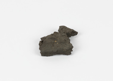
... In 1853-69 the Geological Survey issued under Selwyn's direction sixty-one geological maps and numerous reports; they were of such high standard that a writer in the Quarterly Journal of the Geological Society of London bracketed the survey with that of the United States of America as the best in the world. ...In 1853-69 the Geological Survey issued under Selwyn's direction sixty-one geological maps and numerous reports; they were of such high standard that a writer in the Quarterly Journal of the Geological Society of London bracketed the survey with that of the United States of America as the best in the world. ...Brown Coal is typically found as rocks. During formation the Brown Coal starts as peats, which is an acidic brown deposit resembling soil, and over time when subjected to pressure and heat these peats form the Coal. Brown Coal is the lowest rank of coal as it has a low carbon (energy) content, and a high moisture content. This high moisture content makes Brown Coal unsuitable for overseas exports. This particular specimen was recovered from the Yallourn Mine in Latrobe Valley, Victoria as part of the geological survey of Victoria being carried out by Alfred Selwyn. Otherwise known as the 'Yallourn Power Station', the Yallourn Mine is Australia's second largest mine. Yallourn Mine was first built in 1920, and since then it has been providing over 1 billion tonnes of Brown Coal to Australia every year. The Yallourn Mine is responsible for 22% of Victoria's electricity and 8% of Australia's electricity. As of 2021 the mine employs around 500 people. Due to ongoing maintenance issues and Australia's move to cleaner energy, the Yallourn Mine intends to shut down permanently as of 2028. Soon after gold was discovered in 1851, Victoria’s Governor La Trobe wrote to the Colonial Office in London, urging ‘the propriety of selecting and appointing as Mineral Surveyor for this Colony a gentleman possessed of the requisite qualifications and acquaintance with geological science and phenomena’. Alfred Selwyn was appointed geological surveyor in Australia in 1852 which began the Geological Survey of Victoria. In 1853-69 the Geological Survey issued under Selwyn's direction sixty-one geological maps and numerous reports; they were of such high standard that a writer in the Quarterly Journal of the Geological Society of London bracketed the survey with that of the United States of America as the best in the world. During his years spent in Australia, Selwyn collected numerous significant geological specimens, examples of which are held in collections such as the Burke Museum.Brown coal is considered to be an essential rock to Australia's energy consumption. Although plentiful in sources, Brown Coal is not able to be exported overseas due to its high moisture content. As Australia moves towards cleaner energy, Brown Coal is going become less used. This specimen is part of a larger collection of geological and mineral specimens collected from around Australia (and some parts of the world) and donated to the Burke Museum between 1868-1880. A large percentage of these specimens were collected in Victoria as part of the Geological Survey of Victoria that begun in 1852 (in response to the Gold Rush) to study and map the geology of Victoria. Collecting geological specimens was an important part of mapping and understanding the scientific makeup of the earth. Many of these specimens were sent to research and collecting organisations across Australia, including the Burke Museum, to educate and encourage further study.A solid hand-sized sedimentary rock that is a dark shade of brown.13 / BROWN COAL / Showing Woody structure / Locality: Yallourn, Vic. | Label probably / correct but / can't find reference / no. 13 to match in / registers. / C Willman / 15/4/21burke museum, beechworth, indigo shire, beechworth museum, geological, geological specimen, mineralogy, yallourn, yallourn mine, victoria, coal, brown coal, brown coal specimen, alfred selwyn, geological survey of victoria, geological survey, yallourn power station -
 Eltham District Historical Society Inc
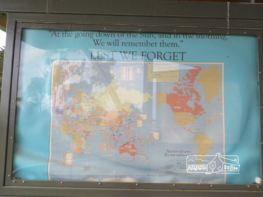
Photograph, Liz Pidgeon, Moor-Rul Viewing Platform Panel: Lest We Forget, 10 August 2016
... map of the world on blue including the words for the "Lest We Forget" lament. The Moor-Rul Viewing Platform, part of the Kangaroo Ground War Memorial Park opened in April 2007. Eight double-sided interpretation panels on the Moor-rul viewing platform highlight the area's Aboriginal and European history of the area and also details of local geology, flora and fauna. ...map of the world on blue including the words for the "Lest We Forget" lament. The Moor-Rul Viewing Platform, part of the Kangaroo Ground War Memorial Park opened in April 2007. Eight double-sided interpretation panels on the Moor-rul viewing platform highlight the area's Aboriginal and European history of the area and also details of local geology, flora and fauna. ...Coloured map of the world on blue including the words for the "Lest We Forget" lament. The Moor-Rul Viewing Platform, part of the Kangaroo Ground War Memorial Park opened in April 2007. Eight double-sided interpretation panels on the Moor-rul viewing platform highlight the area's Aboriginal and European history of the area and also details of local geology, flora and fauna. These panels feature high quality graphic design and professionally written text. The subjects covered are: ''Womin Je Ka" Welcome The Kulin Nation Singing, Dancing, Ceremony, Celebration This Country, My Home The Highland Taken Auld Lang Syne "Same Land Different Views" Working the Land Food from the Earth or "Earth's Harvest" Lest We Forget, "And with the going down of the Sun .... (3 panels) This Black Earth Those other indigenous inhabitants - Kangaroo Ground's Wildlife Silent Witnesses - Kangaroo Ground's White Manna Gums Belonging A Place of Reverence and A Tower of Strength Souce: EDHS Newsletter No 173 March 2007. As part of a program to acknowledge the Anzac Centenary Nillumbik Shire Council partnered with Yarra Plenty Regional Library to provide a bus tour with commentary of local sites of significance: Shire of Nillumbik World War One Memorials tour, 10 August 2016. These included Eltham township, the Shire of Eltham War Memorial at Kangaroo Ground, Christmas Hills war memorial, Hurstbridge memorial recreation park and finshed at Eltham Library to view the Writing the War exhibtion at Eltham Library Community Gallery. Born Digitalworld war 1, war memorials, shire of nillumbik, moor-rul viewing platform, kangaroo ground, shire of eltham war memorial, interpretative signage, interpretation panel, map, display panel
