Showing 255 items
matching gold mining site
-
 Bendigo Historical Society Inc.
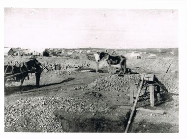
Photograph - WES HARRY COLLECTION: LANDSCAPE VIEW OF EARLY BENDIGO GOLD MINES
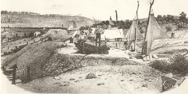
Black and white photo copy: Image shows mine site, horse harnessed to puddling machine, shaft in immediate foreground, with pipe extending into top of shaft. Horse harnessed to cart on LH side. Very early image of mining in Bendigo, no poppet heads visible.Batchelderplace, bendigo, mining, bendigo, mining, gold, puddling -
 Bendigo Historical Society Inc.
Document - BENDIGO AND DISTRICT IN COLOUR
''Bendigo and District in Colour'' Possible full title - see first page. (by Ken and Esther Stepenell). Seven paged very broad coverage of Bendigo's history and attractions. Includes mention of Dai Gum San Village (and proposed site??)Ken and Esther Stepenellbendigo, history, gold mining, bendigo creek, eaglehawk, peg leg, the garden gully, new chum railway, great extended hustlers, white death, chinese, joss house, sun loong dragon, victoria hill, whipstick forest, talking trams, dia gum san village. -
 Bendigo Historical Society Inc.
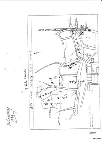
Document - LONG GULLY HISTORY GROUP COLLECTION: THE LONG GULLY GOLF LINKS
Some history of the Long Gully Golf Links, a 9 Hole Course, by John Harvey. First page has a map of the area showing where the holes are and different features. There is a description of the tees and the route taken around the course.Dates when the Eaglehawk, Neangar park, Kangaroo Flat Golf Clubs and the Long Gully Playground were opened.bendigo, history, long gully history group, the long gully history group - the long gully golf links, a crossley, john harvey, long gully rec, dai gum san reservation, quarry hill golf club, bendigo golf club, marong gulf club, miss colgan, sacred heart cathedral choir, mechanics institute, rose of australia hotel, north hercules and energetic mine site, les thomas, tom austen, pearl south mullock heap, doc catford, clubs wearne, pearl mining co's diggings, pearl south, pearl east, bill and faye osterfield, ellen lee osterfield, eaglehawk gold club, neangar park golf club, f m fitzpatrick, kangaroo flat golf club, long gully playground, pearl sands, ennor brothers, birchmore brothers, shirley harvey, belvoir park, harold ennor, george ennor -
 Bendigo Historical Society Inc.
Photograph - CENTRAL BLUE MINE, 1912
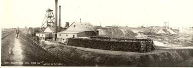
Black and white photo: mine site with poppet head, mine buildings at rear right . Trestles and cables carrying rectangular bins across open land. Large mound of material behind main building. Trees and weatherboard building in foreground. On back written in ball point pen and underlined ' flying Fox' Central Blue Mine to Crushing Battery 1912 'mine, gold, central blue, bendigo, mines and mining, surface equipment, place, mining, surface equipment, flying fox, poppet head -
 Bendigo Historical Society Inc.
Photograph - MINERS AT VICTORIA REEF, c.1857
Black and white photograph of sketch of workmen at mine site. Air ventilators on top of mine shafts to R. Wheelbarrow at R foreground. Wind socks or sails were used to ventilate the holes. History: 'Victoria Reef 1857, Frank Cusack after a photograph by Alex Fox.Alex Foxmine, gold, victoria hill, book 'bendigo, the german chapter' by frank cusack. p52., mines and mining, mine, place, workers, miners, mining equipment, equipment, frank cusack, history -
 Bendigo Historical Society Inc.
Photograph - NEW CHUM RAILWAY GOLD MINE
Black and white photograph. Mine site with poppet head and mine buildings. Stacks of wood in foreground. Two chimneys. Poppet heads and chimneys in background. Inscriptions: in image - printed at BL '..w Chum Railway Gold Mine * 4226 feet, deepest in the world'. 'New Chum Railway 4,318 feet deep. One of the deepest in the world', 'A Richardson, 29 Harrison St, Bendigo'. All written on back in ballpoint pen.mine, gold, new chum hill, 180 mine, bendigo, mines and mining, railway line, gold mine, mines, place, gold mines -
 Bendigo Historical Society Inc.
Photograph - CHEWTON GOLD MINE
black and white photo: mine site, poppet head left centre and mining sheds right and front centre. Chewton Gold Mine/Chewton.Alan Doney Photograph ( J. Lerk 17.3.2000 )organization, business, chewton gold mine -
 Bendigo Historical Society Inc.
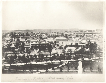
Photograph - SANDHURST - VICTORIA, A GOLD MINING TOWN, Earliest c 1885
B+W Photograph. Copy of 'Sandhurst - Victoria a Gold-Mining Town'. View from Rosalind Park. Notable BLDOR Shamrock Hotel, St Pauls Church, railway station. Inscription: on RH 'Extract from cement -???'. Photograph shows early Sandhurst with Chimney of Goldmine of R.H.S(R.S.L now occupies this site).place, landscape view, sandhurst from rosalind park -
 Bendigo Historical Society Inc.
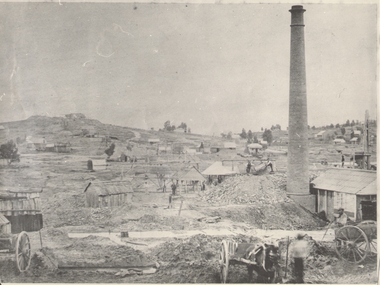
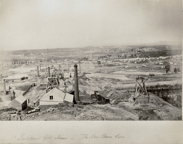
Photograph - GOLD MINES BENDIGO 1861, 1861
Copy of photograph of mine site with dwellings to right top, mine buildings, 'whim?' drays, horse and work men. Large brick chimney on right. B+W photo. On back 'Gold Mines Bendigo 1861','Probably, looking NW up New Chum Hill, which was then known as Sth Victoria Hill'.place, mining site, sth victoria hill ?, see also 131.01 -
 Bendigo Historical Society Inc.
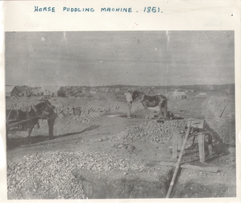
Photograph - HORSE PUDDLING MACHINE VICTORIA HILL?, c.1861
Black and white panorama with mine workings (puddling machine and two horses and two workers) with scattered (residential?) buildings in open rough background. Inscriptions: on front - 'horse puddling machine 1861' hand printed across top. On back - 'Gold Mines Bendigo 1861, this could be Victoria Hill'.place, mining site, victoria hill ? -
 Bendigo Historical Society Inc.
Photograph - NEW CHUM HILL?
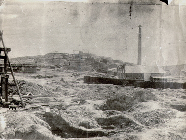
Black and white photograph of mine site. Mullock heap in background with various mine buildings. Chimney stack and corrugated iron buildings on right. Mine shaft holes in foreground. Whims centre back. Hand written on back 'Gold Mines Bendigo. Probably New Chum Hill. Looking North. Phoenix, later Old Chum Mine at summit. JB Lazarus' claims in foreground. RT. 'Johnsons No. 2' on back - Royal Historical Society of Victoria, Bendigo Branch. Circular stamp. History: Prev. ACC. No. MNG 2Batchelderplace, mining site, new chum -
 Bendigo Historical Society Inc.
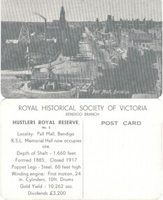
Photograph - HUSTLERS ROYAL RESERVE NO. 2 (POSTCARDS)
Hustlers Royal Reserve No. 2 (Postcards of the Royal Historical Society of Victoria - Bendigo Branch. 10 identical postcards showing mine and Pall Mall, Bendigo. On reverse: LH side with details of locality, shaft, poppet and engine details, gold yield and dividends. RH Side - blank for addresseeplace, mining site, hustlers royal reserve no 2 -
 Bendigo Historical Society Inc.
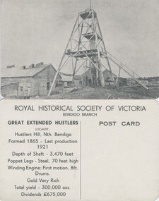
Photograph - GREAT EXTENDED HUSTLERS (POSTCARD)
Great Extended Hustlers (Postcard series of the Royal Historical Society of Victoria (Bendigo Branch). 8 identical cards. Summary history of mine on reverse, LH side: Location, depth, poppet and engine detail, gold yield, dividends. Blank (unused) on RH side for addressee.place, mining site, great extended hustler quartz mine -
 Bendigo Historical Society Inc.
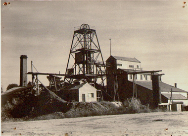
Photograph - NORTH DEBORAH GOLD MINE, c.1920
Black and white photograph. Pool in foreground, mullock heap, poppet head, mine buildings, chimney, trees and town buildings in background. Mounted on masonite. Inscriptions: 'North Deborah' on back.place, mining site, deborah -
 Bendigo Historical Society Inc.
Photograph - DEBORAH GOLD MINE, C.1900
Black and white photograph. Deborah Mine. Poppet head, buildings to right. Square chimney in background. Inscriptions: on back - 'RHSV, Bendigo Branch', '1960', '261'.place, mining site, deborah -
 Bendigo Historical Society Inc.
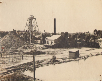
Photograph - THE GREAT HUSTLER GOLD MINE AT SANDHURST, c.1875
Black and white photograph copy of original. Mining site of The Great Hustler, Gold Mine at Sandhurst. Dam on RH side front, mine buildings (various) trestle way in background. Three people beside dam in foreground. Brick chimney back LH side. Inscriptions: 'The Great Hustler, Gold Mine at Sandhurst. Shaft 1250 ft'.place, mining site, great extended hustler quartz mine -
 Bendigo Historical Society Inc.
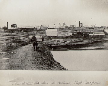
Photograph - THE NEW CHUM LINE OF REEF, c.1870
Black and white photograph. Large view of the New Chum Line mining site. Mines in foreground. Homes in background. Looking South towards Golden Square. Inscriptions: on front - handwritten - 'Sandhurst Gold Mines - The New Chum Line'. C1873, earlier than NH Caire (1875) - James Lerk 12.11.1999.place, mining site, new chum -
 Bendigo Historical Society Inc.
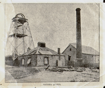
Photograph - VICTORIA QUARTZ - NEW CHUM LINE OF REEF, c.1890
Black and white photograph. Poppet head on LH side, stone building, centre, tall brick chimney, RH side in front of timber building. Inscriptions: on front - 'Victoria Quartz'. On back - typewritten description as follows: 'Situated on the rich Victoria Hill, Ironbark. Steel girders? rams type poppet legs - 60ft high. Vertical winding engines; pair of 24' dia. Winding drums. Made and erected by Roberts & Sons, Bendigo, in 1897. Then one of the best in the state. In 1910 it was the deepest gold mine in the world, having reached a depth of 4,613 ft in the winze. The shaft was then sunk to a depth of 4,588 ft. in an endeavour to reach a depth of 4,870 ft. to effectively work the deepest gold bearing reef in the world. On the night of June 14th, 1910, the mine was flooded out by the rising waters from the deep New Chum mines to the south, all of which had either ceased operations or had returned back to shallow workings. For details of the mine's record, see 'The Historical Guide to Bendigo'. Mine details completed by A Richardson, 29 Harrison Street, Bendigo.place, mining site, victoria quartz -
 Bendigo Historical Society Inc.
Photograph - COATH'S VICTORIA MINE, BENDIGO, c.1852
... PLACE Mining site coath's victoria mine 'Gold Discovery' Jas ...Black and white copy of photograph (in acid free sheets in folder) of eight men in foreground, three behind 'airsail' for mine ventilation. Men are wearing trousers, white shirts, with kerchiefs tied around their heads, straw boaters. Man on RH side dressed in darker clothing, standing on boards ( over a shaft ? ) Piles of mullock on LH side, wheelbarrow and dogs.. History: James Lerk 24/3/2000 - Coath's claim on Victoria Hill (a Fox photo?)place, mining site, coath's victoria mine, 'gold discovery' jas flett p244 -
 Bendigo Historical Society Inc.
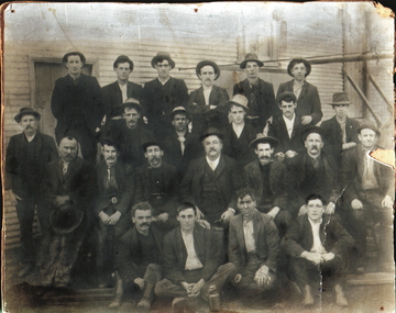
Photograph - NEW CHUM GOLD MINE, c.1911
Black and white photograph of shift of miners, New Chum Mine. Four rows of men against background of timber building. Inscriptions: on back - 'The photo of the New Chum Gold Fields Min Diamond Hill, Bendigo was taken about 1911. The manager Wilfred Rickards seated in centre---', 'GH Furness, 116 High Street, Kangaroo Flat'.place, mining site, new chum -
 Bendigo Historical Society Inc.
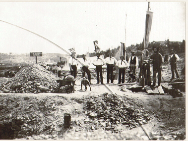
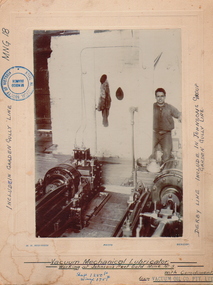
Photograph - JOHNSON'S REEF GOLD LUBRICATOR, c.1880-1890
Vacuum mechanical Lubricator Machinery (vacuum mechanical working at Johnson's Reef Gold, Mine No. 3. Lubricator. Man standing to RH side, hand on lever. Photo mounted on board. Inscriptions: included in Garden Gully Lane MNG18. Derby Line, included in Johnson's Group of Garden Gully Line. Shaft 1250ft. Winze 175ft.place, mining site, johnson's reef -
 Bendigo Historical Society Inc.
Photograph - DEBORAH GOLD MINE 1930'S
Black and white photograph, copy, of the Big Deborah Gold Mine, possibly taken in the 1930's. Deborah mine was near the junction of Abel and Adam Street, Golden Square. Image shows the mine site, a square brick chimney on the extreme RH side, engine room and stamper sheds in the middle and steel poppet head on LH side. Colour photo of Big Deborah, minus less the winding wheels at the top of the poppet legs.bendigo, mining, deborah gold mine -
 Bendigo Historical Society Inc.
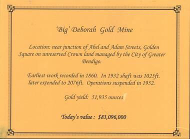
Photograph - DEBORAH GOLD MINE, GOLDEN SQUARE
Information display card regarding the 'Big' Deborah Gold Mine, located near the junction of Abel and Adam Street, Golden Square. Earliest work recorded 1860. Shaft 2076 feet. Operations suspended in 1952. Gold yield 51,935 ounces. Battery shed still on site containing a 5 head stamper which was originally a 20 head stamper. The battery was manufactured by Horwood's Foundry, Bendigo. Photos of mine site taken in 2012: a.Engine room concrete footings, iron work visible. Pepper corn trees in background. Pampas grass in foreground. Steel mesh fence on RH side, enclosing the poppet head site. b. Concrete footings, peppercorn tree in background. c. Corrugated iron shed constructed over the stampers. Steel mesh front. d. Steel poppet head, no winding wheel at top. Pampas grass in foreground. e.. Stamper shed and steel poppet legs in background enclosing dilapidated wooden poppet head legs. f. Close up image of weights in stamper room g.Winding wheel on stampers h.Looking upwards to top of stampersbendigo, mining, deborah gold mine -
 Bendigo Historical Society Inc.
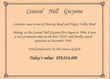
Document - CENTRAL NELL GWYNNE GOLD MINE
Interpretive sign and 4 photos Central Nell Gwynne Gold Mine, used in display. Central Nell Gwynne was located near the corner of Marong Road and Happy Valley Road. Opened in 1906, ceased operation in December 1949. Total production: 61,884 ounces of Gold. Today's Value: $99,014,400. Photos: a. Colour photo, concrete footings at mine site, April 2012. b. Colour photo, Central Nell Gwynne poppet head, April 2012.Poppet head painted white with red trim. Concrete footings in foreround. c. Central Nell Gwynne mine site 1930's. Poppet head and engine room sheds on LH side, trestle way to primary crusher and crushing battery. Tailing dam in immediate foreground. on RH side. Sand heaps in middle foreground. d. Central Nell Gwynne Mine 1930. Underground view, men holding carbide lamps working at 265 level in mine. Large quartz spur formation visible in foreground.bendigo, mining, central nell gwynne -
 Bendigo Historical Society Inc.
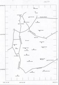
Document - CENTRAL DEBORAH GOLD MINE : GOLDEN SQUARE MINE SITES
Map showing mines in the Golden Square, Diamond Hill area. Roads include Diamond Hill Road, Burns Street, Woodward Road, Belle Vue Road, Houston Street. Latitude and Longitude on map.bendigo, mining, golden square mine sites -
 Bendigo Historical Society Inc.
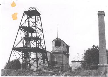
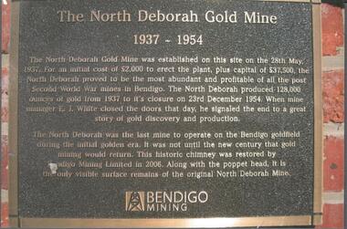
Photograph - NORTH DEBORAH GOLD MINE BENDIGO MINING PLAQUE
Metal plaque, gold writing, erected at the site of the former North Deborah Gold Mine when the brick chimney was restored by Bendigo Mining NL. The plaque reads: 'The North Deborah Gold Mine, 1937-1954. The North Deborah Gold mine was established on this site on the 28th May 1937. For an initial cost of 2,000 pounds to erect the plant, plus capital of 37,500 pounds, the North Debnorah proved to be the most abundant and profitable of all the post Second War mines in Bendigo. The North Deborah produced 128,000 ounces of gold from 1937 to its closure on 23rd December 1954. When mine manager E.J. White closed the doors that day he signaled the end to a great story of gold discovery and production. The North Deborah was the last mine to operate on the Bendigo goldfield during the initial golden era. It was not until the new century that gold mining would return. This historic chimney was restored by Bendigo Mining Limited in 2006. Along with the poppet head. It is the only visible surface remains of the original North Deborah Mine.' The mine site is situated off Breen Street in Golden Square.Kay MacGregor 2012bendigo, mining, north deborah mining company -
 Bendigo Historical Society Inc.
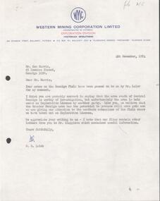
Letter - KANGAROO FLAT MINE SITE COLLECTION: WESTERN MINING LETTERS RE EXPLORATION
Letter from Western Mining Corporation to Mr Ken Harris of 85 Lowndes Street, Bendigo, 4th December 1974, concerning the exploration of the area south of Central Deborah Gold Mine. Ken Harris sent briefing notes on Bendigo mining to Mr. A.H Parbo, the Chairman and Managing Director of Western Mining Corporation, which were then passed onto D.R. Quick of WMC, the author of this letter.bendigo, gold mining, exploration, bendigo, western mining corporation, gold mining, central deborah, a.h. parbo, ken harris -
 Bendigo Historical Society Inc.
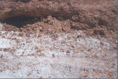
Photograph - RALPH BIRRELL COLLECTION: WHITE HILLS MINING SITE
Colour photograph 'showing tunnels below the cement where the miners chipped the undersurface to get the gold The thickness of the cement can be seen'. Loose sand and gravel above the cement has already been removed. Image shows mining tunnel visible going in under the cement. White clay in foreground. (see Mosaic 4400.220 for detailed information regarding the White Hills, written by Dr. Ralph Birrell)bendigo, mining, white hills -
 Bendigo Historical Society Inc.
Document - GLASGOW AND GOLCONDA CONSOLIDATED GOLD MINE
Information regarding the Glasgow and Golconda Consolidated Gold Mine, Golden Gully. Mine is on the Napoleon Reef, shaft depth of 800 ft. A description of the physical remains is given and the significance of the site is described. It is the only site in Bendigo 'which retains evidence of the tramway between the mine and the battery site'bendigo, mining, glasgow golconda mine site -
 Bendigo Historical Society Inc.
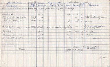
Document - CATHERINE REEF GOLD MINE, 1856 - 1920
3 hand written pages of notes. Information includes Name of Company, Depth of Shaft, Period From & To, Calls, Divs, Tons, Ounces, Authority and Remarks. Pages 136, 137 and 138.place, mining site, catherine reef, catherine reef