Showing 82 items matching "greensborough bypass"
-
 Greensborough Historical Society
Photograph - Photograph Collection, Mary Smyth, Sellars Street, 1984
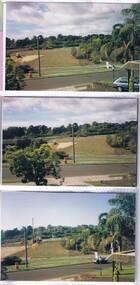
... greensborough bypass... of the Greensborough Bypass.... of the Greensborough Bypass. Early photos of the construction of Greensborough ...A series of photographs taken from Sellars Street in Watsonia North, showing early stages of the construction of the Greensborough Bypass.Early photos of the construction of Greensborough Bypass.20 colour photographs, various sizes.sellars street watsonia north, greensborough bypass -
 Eltham District Historical Society Inc
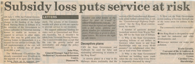
Work on paper - Newspaper article, Diamond Valley News, Subsidy loss puts service at risk, 1 July 1998
... greensborough bypass... Bypass / Greensborough Highway Duplication by Karen Geradts... to the editor refers to the Ring Road / Greensborough Bypass ...Letter to the editor published in the Diamond Valley News,, July 1, 1998 by John Wise, General Mananger Aged Services, Melbourne Citymisson Retirement Centre, Diamond St. stating the situation regarding a reduction in subsidies by the State Goverment and the organisations committment to upgrade the facilities. In 2021, Judge Book is known as St Vincent's Care Services Eltham. Another letter to the editor refers to the Ring Road / Greensborough Bypass / Greensborough Highway Duplication by Karen Geradts, convenor of the St Andrews & District Branch of the Australian Greens. judge book memorial village, aged care, melbourne city mission, seniors, funding, ring road, nursing home, aged care facility, john wise, greensborough bypass, greensborough highway, karin geradts, st andrews & district branch of the australian greens, judgebook -
 Eltham District Historical Society Inc
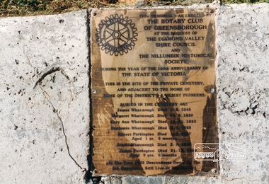
Photograph, Memorial plaque erected in 1985 marking the site of the private cemetery and adjacent to the home of some of earliest pioneers of the Greensborough District, 1990c
... titled 'Greensborough Bypass 1990s 5' suffering significant... 'Greensborough Bypass 1990s 5' suffering significant degradation ...Erected by the Rotary Club of Greensborough at the request of The Diamond Valley Shire Council and Nillumbik Historical Society as part of the Victorian 150th Anniversary commemorations. Names include James Whatmough, Margaret Whatmough, Many Ann Whatmough, Benjamin Whatmough, Jessie Whatmough, Robert Partington and James Partington.Photograph originally located in a magnetic style album titled 'Greensborough Bypass 1990s 5' suffering significant degradation. No information contained in album or on reverse of photos except where noted. Relocated to archival photosafe storage.greensborough, rotary club of greensborough, robert partington, nillumbik historical society, margaret whatmough, many ann whatmough, jessie whatmough, james whatmough, james partington, early settlers, diamond valley shire, cemetery, benjamin whatmough -
 Greensborough Historical Society
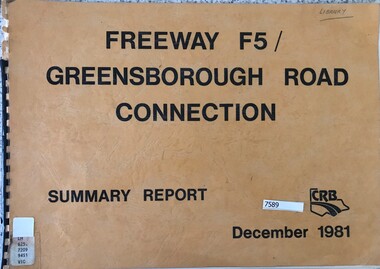
Book - Report, Country Roads Board, Freeway F5 / Greensborough Road connection. December 1981, Summary Report, 1981_
... greensborough bypass... greensborough bypass metropolitan ring road greensborough road 51 pages ...Summary report of the Country Roads Board's 1981 proposals for the F5 Freeway (now Metropolitan Ring Road) between Dalton Road and Diamond Creek Road and the duplication of Greensborough Road (Greensborough By-pass).Historic proposal for roads in the Greensborough area51 pages, text, colour maps. Plastic binding.country roads board, greensborough bypass, metropolitan ring road, greensborough road -
 Greensborough Historical Society
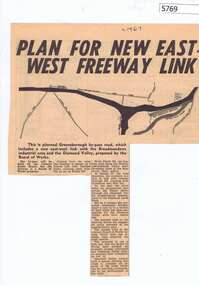
Newspaper Clipping, Diamond Valley News, Plan for new East-West freeway link, 1967c
... greensborough bypass... by-pass and western ring road. greensborough bypass western ring ...Early plans for the Greensborough by-pass and western ring road.Newspaper clipping, black and white text and image.greensborough bypass, western ring road -
 Greensborough Historical Society
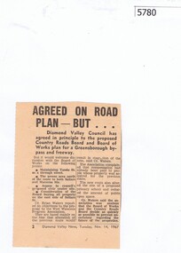
Newspaper Clipping, Diamond Valley News, Agreed on road plan ... but, 14/11/1967
... greensborough bypass..., with further discussion needed on some points. greensborough bypass ...Diamond Valley Council agreed in principle to the proposed Greensborough By-pass and freeway, with further discussion needed on some points.Newspaper clipping, black and white text.greensborough bypass, shire of diamond valley -
 Greensborough Historical Society
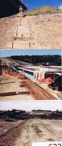
Photographs, Gary Partington, Greensborough By-Pass, 1986_
... greensborough bypass... of the Greensborough by-pass. greensborough bypass roads greensborough gary ...The Greensborough by-pass extends from Grimshaw Street in the south to Diamond Creek Road in the north. It is intersected by the eastern end of the Metropolitan Ring Road.Unpublished photographs of the construction of the Greensborough by-pass.21 colour photographs of the construction phase of the Greensborough By-pass.greensborough bypass, roads, greensborough, gary partington, metropolitan ring road -
 Greensborough Historical Society
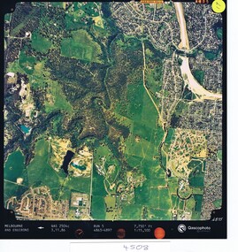
Aerial photograph, Qascophoto, Greensborough, 03/11/1986
... greensborough bypass... Greensborough plenty gorge park greensborough bypass metropolitan ring ...Aerial survey of Plenty Gorge Park area, including Greensborough by-pass construction and Metropolitan Ring Road reservation.An historical view of developing GreensboroughColour aerial photograph QAS 2504c run 5 3/11/86 1:15,500 by Qascophotoplenty gorge park, greensborough bypass, metropolitan ring road -
 Greensborough Historical Society
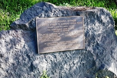
Photograph - Digital image, Marilyn Smith, Greensborough By-pass Plaque, 03/03/1988
... greensborough bypass.... greensborough bypass Digital copy of 3 colour photographs Greensborough ...This plaque commemorated the official opening of the Greensborough By-pass on 3rd March 1988.Digital copy of 3 colour photographsgreensborough bypass -
 Greensborough Historical Society
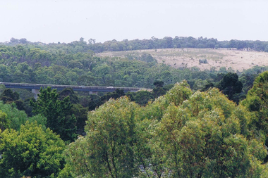
Photograph - Digital image, Frank Solomon, View over Greensborough to Plenty River Drive bridge, 2010c
... greensborough bypass... greensborough bypass Digital copy of colour photograph View over ...View over trees to the Greensborough By-pass bridge over Plenty River Drive.Digital copy of colour photographplenty river drive, greensborough bypass -
 Eltham District Historical Society Inc
Photograph, The Maroondah Aqueduct System Old Pipe Bridge, Plenty River Walk, Greensborough, c.1989, 1989c
... album titled 'Greensborough Bypass 1990s 5' suffering... 'Greensborough Bypass 1990s 5' suffering significant degradation ...Colour photograph originally located in a magnetic style album titled 'Greensborough Bypass 1990s 5' suffering significant degradation. No information contained in album or on reverse of photos except where noted. Relocated to archival photosafe storage.greensborough, plenty river walk, maroondah aqueduct -
 Eltham District Historical Society Inc
Photograph, The Batman Tree; heirloom apple tree purchased by John Batman and planted by Mr Frederick Flintoff in 1838 in the orchard of Mr Bosch, near Greensborough, now a small river flat near the Maroondah aqueduct crossing, Plenty River Walk, Greensborough, c.1989, 1989c
... album titled 'Greensborough Bypass 1990s 5' suffering... style album titled 'Greensborough Bypass 1990s 5' suffering ...Colour photograph originally located in a magnetic style album titled 'Greensborough Bypass 1990s 5' suffering significant degradation. No information contained in album or on reverse of photos except where noted. Relocated to archival photosafe storage.greensborough, plenty river walk, maroondah aqueduct, batman apple tree -
 Eltham District Historical Society Inc
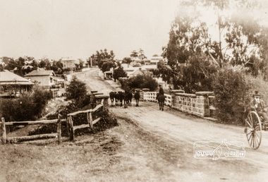
Photograph, Main Street, Greensborough, c.1900, 1900c
... album titled 'Greensborough Bypass 1990s 5' suffering... 'Greensborough Bypass 1990s 5' suffering significant degradation ...Shows view looking up Main Street, Greensborough across the Plenty River BridgePhotograph copy originally located in a magnetic style album titled 'Greensborough Bypass 1990s 5' suffering significant degradation. No information contained in album or on reverse of photos except where noted. Relocated to archival photosafe storage.greensborough, main street, plenty river bridge -
 Eltham District Historical Society Inc
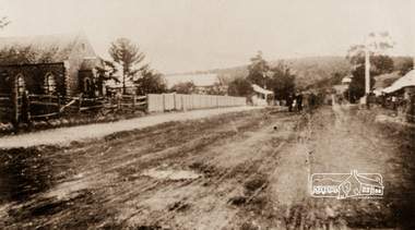
Photograph, Main Street, Greensborough, c.1910, 1910c
... album titled 'Greensborough Bypass 1990s 5' suffering... in a magnetic style album titled 'Greensborough Bypass 1990s 5 ...Early view of Main Street Greensborough showing the mainly residential nature of the buildings. Photographs from the collection of Peter Blackbourn, a descendant of the Chapman Stock family.Photograph copy originally located in a magnetic style album titled 'Greensborough Bypass 1990s 5' suffering significant degradation. No information contained in album or on reverse of photos except where noted. Relocated to archival photosafe storage.greensborough, main street -
 Eltham District Historical Society Inc
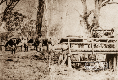
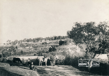
Photograph, Steam engine being hauled by bullock team, possibly over the Plenty River Bridge, Main Street, Greensborough, c.1870, 1870c
... album titled 'Greensborough Bypass 1990s 5' suffering... style album titled 'Greensborough Bypass 1990s 5' suffering ...Photograph copy originally located in a magnetic style album titled 'Greensborough Bypass 1990s 5' suffering significant degradation. No information contained in album or on reverse of photos except where noted. Relocated to archival photosafe storage.greensborough, main street, plenty river bridge, steam engine, bullock team -
 Eltham District Historical Society Inc
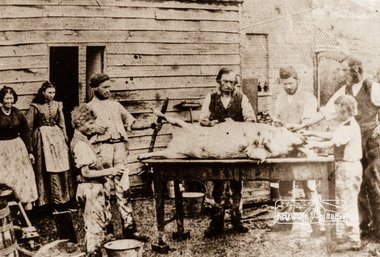
Photograph, Butchering a pig, possibly Greensborough, c.1870, 1870c
... album titled 'Greensborough Bypass 1990s 5' suffering... in a magnetic style album titled 'Greensborough Bypass 1990s 5 ...Photograph copy originally located in a magnetic style album titled 'Greensborough Bypass 1990s 5' suffering significant degradation. No information contained in album or on reverse of photos except where noted. Relocated to archival photosafe storage.greensborough -
 Eltham District Historical Society Inc
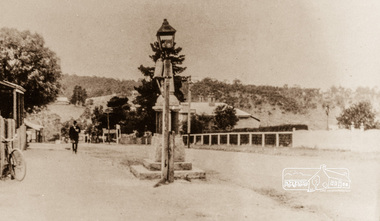
Photograph, Main Street, Greensborough, 1920s, 1920s
... style album titled 'Greensborough Bypass 1990s 5' suffering... style album titled 'Greensborough Bypass 1990s 5' suffering ...Looking towards the Plenty River from outside the current premises of the State Savings Bank. In the foreground is one of the old carbide street lamps. Behind the lamp is the drinking fountain erected as a memorial to Greensborough's Great War (First World War) Diggers. This memorial is now in the park in Henry Street, (Photo: Nillumbik Historical Society)Colour photograph copy originally located in a magnetic style album titled 'Greensborough Bypass 1990s 5' suffering significant degradation. No information contained in album or on reverse of photos except where noted. Relocated to archival photosafe storage.greensborough, main street -
 Eltham District Historical Society Inc
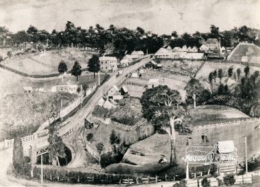
Photograph, View of 'Willis Vale', Greensborough, 1906, 1906c
... in a magnetic style album titled 'Greensborough Bypass 1990s 5... album titled 'Greensborough Bypass 1990s 5' suffering ...'Willis Vale' home of the Partington family is shown in this photograph as well as the area now known as Partington's Flat. The area was owned and farmed by the Partington family from the 1870s. Willis Vale was destroyed by fire in the 1960sBlack and white photograph copy originally located in a magnetic style album titled 'Greensborough Bypass 1990s 5' suffering significant degradation. No information contained in album or on reverse of photos except where noted. Relocated to archival photosafe storage.greensborough, partingtons flat, partington family, willis vale -
 Eltham District Historical Society Inc
Photograph, Painting, Greensborough, Arthur Elliott (1889), 1906c
... in a magnetic style album titled 'Greensborough Bypass 1990s 5... 'Greensborough Bypass 1990s 5' suffering significant degradation ...Shows Main Street Greensborough with the Methodist Church in upper right corner, Lower Park and bluestone bridge in foreground.Black and white photograph copy originally located in a magnetic style album titled 'Greensborough Bypass 1990s 5' suffering significant degradation. No information contained in album or on reverse of photos except where noted. Relocated to archival photosafe storage.greensborough, main street, arthur elliott -
 Eltham District Historical Society Inc
Photograph, View looking southwest from near Manatunga Circuit across the Diamond Valley United Soccer Club field, Greensborough, c.1986, 1986c
... located in a magnetic style album titled 'Greensborough Bypass... in a magnetic style album titled 'Greensborough Bypass 1990s 5 ...Greensborough Plaza at far left. Railway line running horizontally across centre of picture. Three colour photographs and one digital panorama created from two of the three images. Colour photographs originally located in a magnetic style album titled 'Greensborough Bypass 1990s 5' suffering significant degradation. No information contained in album or on reverse of photos except where noted. Relocated to archival photosafe storage.manatunga circuit, greensborough plaza, diamond valley united soccer club, greensborough -
 Greensborough Historical Society
Map, Melbourne and Metropolitan Board of Works. Survey Division, MMBW, Yarra 2500 / 13.22. Greensborough, Apollo Parkways, 1979_06
... and "proposed freeway" now Greensborough Highway (Bypass)...Greensborough Historical Society 34A Glenauburn Road Lower ...Melbourne and Metropolitan Board of Works. Yarra 2500 [base map] 13-22. Greensborough, Apollo Parkways. Parishes of Nillumbik 3310 and Keelbundora 2856. Municipalities of Diamond Valley 257 and Whittlesea 239. Prominent streets include: Plenty River Drive, Diamond Creek Road and Civic Drive. Includes Diamond Valley Civi Centre, Churinga, Janefield Colony Reserve and "proposed freeway" now Greensborough Highway (Bypass)MMBW Map in 1:2500 [scale] series. Cream parchment with green tape reinforcing on edges and punched holes on left edge.mmbw, melbourne and metropolitan board of works, shire of diamond valley, greensborough - maps, apollo parkways - maps -
 Greensborough Historical Society
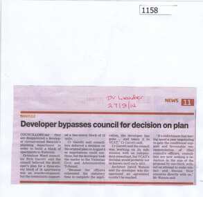
Newspaper clipping, Developer bypasses council for decision on plan, 27/08/2014
The proposal for a block of apartments in Watsonia will go to the Victorian Civil and Administrative Tribunal after the developer failed to reach an agreement with Banyule City Council.News clipping, black text.watsonia, town planning, unit development watsonia