Showing 6867 items
matching gully
-
 Eltham District Historical Society Inc
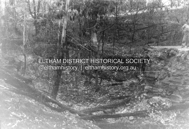
Album - Photograph, J.A. McDonald, Salters Rush Road, Smiths Gully, Aug. 1962
Salters Rush Road, Smiths Gully Bridge over Salters Rush Creek following bush fires 15-16 Jan. 1962Record of various Shire of Eltham infrastructure works undertaken during the period of 1952-1962 involving bridge and road reconstruction projects, sometimes with Eltham Shire Council Project Reference numbers quoted. It was during this period that a number of significant improvements were made to roads and new bridges constructed within the shire that remain in place as of present day (2022). In many situations, the photos provide a tangible visible record of infrastructure that existed throughout the early days of the Shire. The album was put together by or under the direction of the Shire Engineer, J.A. McDonald.H941 stamped on reverse (film processing #)infrastructure, shire of eltham, bridge construction, road construction, 1962-08, bushfires, salters rush road, smiths gully, victorian bushfires - 1962 -
 Mt Dandenong & District Historical Society Inc.
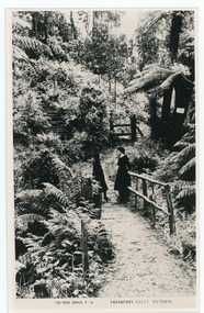
Photograph, Sassafras Gully, Victoria, c1920
The tourist track running alongside the creek from Sassafras Mechanics’ Hall to Emerald. In the early 1900s the track started at Rostrevor Guest House.Black and white copy of Rose Series Post card P. 74 showing two young women standing on a footbridge at Sassafras Gully. A set of steep steps can be seen above them.rose series, track, footbridge, bridge, sassafras -
 Falls Creek Historical Society
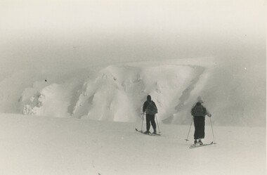
Photograph - Bogong Trip 1951- Cairn Gully and West Peak
MEYER COLLECTION - FALLS CREEK PHOTOS In 1947 a determined group of like-minded State Electricity Commission (SEC) staff including Ray Meyer, the chief surveyor of the Kiewa Hydro-Electric Scheme, had a common interest that revolved around the skiing potential of the snow-covered high plains which included what is now the resort of Falls Creek. The six SEC employees, Toni St Elmo, Ray Meyer, Jack Minogue, Lloyd Dunn, Adrian Ruffenacht and Dave Gibson (together with their families) banded together to secretly build a 'hut' that was the first ski lodge at Falls Creek. Using a road built in 1930s to gain access to Falls Creek, their hut project was carried out in secret as efforts by other skiers were blocked by H.H.C. Williams – the engineer in charge of the Hydro Scheme. In 1946 Ray Meyer made a trip to the Lands Office in Melbourne. He came away with a 99-year lease on three acres that was ideally suited for a hut designed by Lloyd Dunn. Adrian Ruffenacht (Design Engineer for the KHS) had suggested where the group should build because of easy access to a spring for water. Much of the building material required was scavenged from derelict huts on the high plains. Due to the need for secrecy, the determined group worked on the hut in the evenings and weekends to avoid detection. During the building period the group had met at Echidna Rock (now known as Eagle Rock) where Skippy St Elmo announced, "This is my favourite ‘Skyline’.” And so the first lodge in the area at Falls Creek Ski Resort came into existence. With the development of the International Poma in the 1970s, the Skyline Lodge, which was sited between the ski-lift’s pole one and pole two, was demolished. However, the legacy of Ray Meyer, Toni St Elmo, Jack Minogue, Lloyd Dunn, Adrian Ruffenacht and Dave Gibson and Skyline lives on in the vibrant atmosphere of Falls Creek Resort. The MEYER COLLECTION documents developments on the Kiewa Hydro Scheme and their life at Falls Creek from the mid 1930s to 1960s.This image is significant because it depicts aspects of the life of a pioneering family of Falls Creek and the founders of "Skyline", the first lodge at Falls Creek.Two black and white images taken on a trip to Mt. Bogong in 1951. 1. West Peak from Eskdale Saddle - Ray Meyer and Wal Johnson 2. Cairn Gully and West Peakfalls creek, bogong high plains, staircase spur memorial, ray meyer, wal johnson -
 Eltham District Historical Society Inc
Photograph, Bridge over Smiths Gully Creek, Heidelberg-Kinglake Road, St Andrews, c.1968, 1968c
Looking northwest from Smiths Gully creek at the bridge on Scott Street (Heidelberg-Kinglake Road) just east of the intersection with Burns Street (Kangaroo Ground-St Andrews Road), and the St Andrews MarketBlack and white photograph (x 2)H-KL at KG SAbridge, burns street, heidelberg-kinglake road, infrastructure, kangaroo ground-st andrews road, scott street, shire of eltham, shire of eltham infrastructure, smiths gully creek, st andrews, st andrews market -
 Federation University Historical Collection
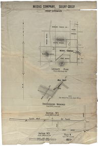
Plan, Midas Company, Sulky Gully near Creswick
Locality and Underground Workings plan for the Midas Company, Sulky Gully near Creswick. Companies shown on the Locality Plan include Dowling Forest No 1., Midas Consols, Madam Midas, Midas Company, King Midas and Midas Extended.dowling forest no 1., midas consols, madam midas, midas company, king midas, sulky gully, creswick, midas extended, cgt -
![Dandenong State Forest, at Fern Tree Gully / [by] Nicholas Caire, circa 1876](/media/collectors/550653872162f11fb04854aa/items/577750a4d0cdd10a5c15e22b/item-media/57775147d0cdd10a5c165a58/item-fit-380x285.jpg) Kew Historical Society Inc
Kew Historical Society IncPhotograph, Anglo-Australasian Photographic Company, Dandenong State Forest, at Fern Tree Gully, c. 1876
Nicholas Caire was born on Guernsey in the Channel Islands in 1837. He arrived in Adelaide with his parents in about 1860. In 1867, following photographic journeys in Gippsland, he opened a studio in Adelaide. From 1870 to 1876 he lived and worked in Talbot in Central Victoria. In 1876 he purchased T. F. Chuck's studios in the Royal Arcade Melbourne. In 1885, following the introduction of dry plate photography, he began a series of landscape series, which were commercially successful. As a photographer, he travelled extensively through Victoria, photographing places few of his contemporaries had previously seen. He died in 1918. Reference: Jack Cato, 'Caire, Nicholas John (1837–1918)', Australian Dictionary of Biography, National Centre of Biography, Australian National UniversityAn original, rare photograph from the series 'Views of Victoria: General Series' by the photographer, Nicholas Caire (1837-1918). The series of 60 photographs that comprise the series was issued c. 1876 and reinforced a neo-Romantic view of the Australian landscape to which a growing nationalist movement would respond. Nicholas Caire was active as a photographer in Australia from 1858 until his death in 1918. His vision of the Australian bush and pioneer life had a counterpart in the works of Henry Lawson and other nationalist poets, authors and painters.Albumen silver photograph on boardprinted in ink on support l.c.: DANDENONG STATE FOREST, AT FERN TREE GULLY. / COPYRIGHT REGISTERED. printed in ink on support reverse c.: VIEWS OF VICTORIA. / (GENERAL SERIES.) / No. 12. / DANDENONG STATE FOREST, AT FERN TREE GULLY. / Fern Tree Gully is one of the favourite resorts for pleasure-seekers on holiday occasions. This scene is taken / from the camping ground at the entrance to the Gully. The residence in the centre of the picture is that of the / Forest-keeper, Mr. Kennedy, who has charge of the Dandenong State Forest. The trees on the hill at the back of / the residence, through apparently diminutive, are in reality gigantic ones, measuring in many instances from 15 to / 20 feet in circumference at the base. printed in ink on support reverse l.c.l.: J.W. FORBES, Agent, printed in ink on support reverse l.c.: ANGLO-AUSTRALASIAN PHOTOGRAPHIC COMPANY, MELBOURNE. printed in ink on support reverse l.c.r.: 10 Temple Court, Collins Street West.nicholas caire (1837-1918), landscape photography, ferntree gully -
 Melbourne Tram Museum
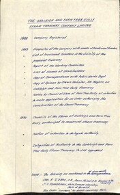
Document - Research Notes, H. S. McComb, "The Oakleigh and Ferntree Gully Steam Tramway Company Limited", 1960's?
Handwritten timeline on foolscap paper, titled "The Oakleigh and Ferntree Gully Steam Tramway Company Limited", giving years and events and reference documents with reference on the second page to a sketch plan from various documents. Dates 1888 to 1890. Map not with document.trams, tramways, steam trams, oakleigh, ferntree gully -
 Ringwood and District Historical Society
Book, Murray Houghton, Selby Store, Thomson's Gully, Warrandyte, 2010
Full title: "Selby Store", Thomson's Gully, Warrandyte, Constructed for Daisy Hawkes, 1939; Later trading as the "Stonehouse" and today (2010) as "The Yarra Store". A three-part survey of published literatue, with introduction and historical summary prepared for the Warrandyte Historical Society, Inc.With spcial reference to Captain Alfred Selby, owner of "Selby Freehold", Warrandyte; Thomas Hawkes & Family, residents of "Greenham", North Warrandyte; Miss Daisy Hawkes, proprietor of "Selby Store". -
 Ringwood and District Historical Society
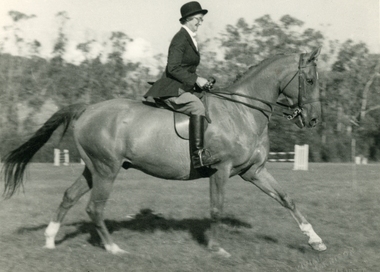
Photo of Mrs VE Knee in an equestrian event at Ferntree Gully, Vivian Harrison
Mrs VE Knee competing at the Ferntree Gully Gymkhana. Winner of the Open section. Horse was call Turn Out. Also won the Hack at Colac Show, Templestowe Gymkhana Cup Day (1st Hearey Hack Ladies), Bunyip Show (1st Hearey Weight Hack). "Eisenhower". Photographer - Vivian Harrison, Melbourne. -
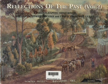
 Narre Warren and District Family History Group
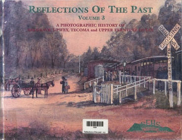
Book, John Waterhouse et al, Reflections of the Past - A photographic History of Belgrave, Upwey, Tecoma and Upper Ferntree Gully, 1999
Following the success of Volumes 1 and 2, this third edition is slightly different to the first ones in that it has filled some of the gaps by gathering photos not previously covered. It has been expanded to having 128 pages with fewer historical errors. The historical society's main interest is the history of the Dandenong Ranges and the communities of Belgrave, Tecoma, Upper Ferntree Gully, Upwey and surrounds. It covers local artists, halls, schools, train stations and Puffing Billy.A photographic history of Belgrave, Upwey, Tecoma and Upper Ferntree Gully. The front cover is of a painting of the Upwey Railway Station with Puffing Billy in 1912 by Charlie Hammond. The train is being met by the Tullidge sisters, Francis, Sarah and Emily. Inside, are black and white and coloured photographs of paintings, people in general life and historical information about the areas noted. (Mont de Lacey)non-fictionFollowing the success of Volumes 1 and 2, this third edition is slightly different to the first ones in that it has filled some of the gaps by gathering photos not previously covered. It has been expanded to having 128 pages with fewer historical errors. The historical society's main interest is the history of the Dandenong Ranges and the communities of Belgrave, Tecoma, Upper Ferntree Gully, Upwey and surrounds. It covers local artists, halls, schools, train stations and Puffing Billy.dandenong ranges, photographic history -
 Eltham District Historical Society Inc
Photograph - Digital Photograph, Marguerite Marshall, One Tree Hill Mine, Smiths Gully, 8 June 2006
Gold was discovered on One Tree Hill in 1854. The site has been worked intermittently until fairly recent times. Published: Nillumbik Now and Then / Marguerite Marshall 2008; photographs Alan King with Marguerite Marshall.; p53 Though still a working mine, One Tree Hill Mine at Smiths Gully, now stands in a tranquil reserve surrounded by bush and native animals - in contrast to its heyday. In the mid 19th century, when the mine was part of the Caledonia Goldfields, hundreds of men in search of their fortune worked the alluvial gold in the Yarra River, its tributaries and the reefs that made up the goldfields. Miner Stan Bone, assisted by Wilfred Haywood, is the last of the independent gold miners in the area and still uses the quartz crushing battery as miners did when gold was first discovered in the area in 1851.1 Stan, who is the last of six generations of miners in his family, was aged 17 when he began mining on his father Alex’ mine, The Golden Crown in Yarrambat. These days, after blasting the gold-bearing rock in Mystery Reef, one of the four reefs at One Tree Hill, Stan transports it around five kilometres by tip truck to the Black Cameron Mine for crushing. There he uses water from the waterlogged mine, (which still contains gold), as the Happy Valley Creek at One Tree Hill is usually dry.2 The One Tree Hill Mine has been worked for close to a century since it opened around the late 1850s.3 The Swedish Reef was its most productive reef and one of the largest in the area. Around 1859, extractions included 204 ounces (5.8kg) of gold, won from 57 pounds (26kg) of stone.4 Then during World War Two, Stan’s uncle, Bill Wallace, and Alex Bone, closed the mine. In 1973, Stan, with his Uncle Bill, reopened the Black Cameron Mine and worked there until 1988. Stan resumed mining One Tree Hill in 1998. As late as the 1920s gold was picked up by chance! When crossing a gully on his way to vote at the St Andrews Primary School, Bill Joyce picked up some quartz containing gold. This site was to become the Black Cameron Mine. The Caledonia Diggings, named after Scotland’s ancient name by local Scots, began around Market Square (now Smiths Gully) and included Queenstown (St Andrews), Kingstown (Panton Hill) and Diamond Creek. There were also poorer bearing fields in Kangaroo Ground and Swipers Gully (now Research). * None of these compared in riches to the Ballarat and Bendigo fields5, but the Caledonia Diggings continued intermittently for close to 100 years. Gold was discovered in Victoria following a bid to stem the disappearance of much needed workmen to the New South Wales diggings. Several businessmen offered a reward of £200, for the discovery of gold within 200 miles (322 km) of Melbourne. Late in June 1851, gold was first discovered at Andersons Creek, Warrandyte. Then in 1854, George Boston and two other men discovered gold at Smiths Gully. Gold transformed the quiet districts, with a constant flow of families and vehicles on the dirt tracks en route to the Caledonia Diggings. Three thousand people worked the gullies in Market Square, including about 1000 Chinese miners. The square established its own police, mining warden, gold battery, school, shops and cemetery and grog flowed. Market Square flourished until the middle 1860s. Bullocks transported quartz from the Caledonia Goldfields to the crushing machinery at the Queenstown/St Andrews Battery, near Smiths Gully Cemetery. It was destroyed by bushfire in 1962. By the late 1850s, most early alluvial fields were in decline, but minor rushes continued until around 1900 and some until the early 1940s. Some miners did well, although most earned little from their hard labour in the harsh and primitive conditions.6 But according to historian, Mick Woiwod, the gold fields helped to democratise society, as individuals from all walks of life were forced to share experiences, and the ability to succeed, depended less on inherited wealth or social rank.This collection of almost 130 photos about places and people within the Shire of Nillumbik, an urban and rural municipality in Melbourne's north, contributes to an understanding of the history of the Shire. Published in 2008 immediately prior to the Black Saturday bushfires of February 7, 2009, it documents sites that were impacted, and in some cases destroyed by the fires. It includes photographs taken especially for the publication, creating a unique time capsule representing the Shire in the early 21st century. It remains the most recent comprehenesive publication devoted to the Shire's history connecting local residents to the past. nillumbik now and then (marshall-king) collection, gold mining, one tree hill mine, smiths gully -
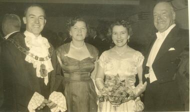 Ringwood and District Historical Society
Photograph, Mayoral Ball 10th June, 1955, at Ringwood. Cr R Horman, Mrs Pickett, Mrs Horman, Cr F Pickett, President of Ferntree Gully
Ringwood Mayoral Ball 10th June, 1955. Cr R Horman, Mrs Pickett, Mrs Horman, Cr F Pickett, President of Ferntree Gully. All material is from Gwen Horman’s three albums that she owned. Some photos have been taken by Peter Payens of Ringwood Studios, 36 Whitehorse Road, Ringwood, WU-7609, probably for the Ringwood mail newspaper. -
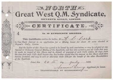 Linton and District Historical Society Inc
Certificate - Mining Lease, North Great West Q.M. Syndicate, Bryant's Gully, Linton, 1899, 1899
Grey paper, black printing, headed North Great West Q.M. Syndicate, dated 24th July 1899, signed Samuel Devy. Decorative design printed in left hand margin. Number "4" on certificate. Serrated left edge of certificate suggests it was detached from a booklet or form. The certificate was issued to A. C. Cork and entitled him to a one-tenth interest in an application for a mining lease at Bryant's Gully, Linton.mining, leases, north great west q.m. syndicate, bryant's gully, linton, a.c. cork -
 Narre Warren and District Family History Group
Book, John Waterhouse et al, Reflections of the Past - A photographic History of Belgrave, Upwey, Tecoma and Upper Ferntree Gully, 1998
Following the success of Volume 1, this follow-up edition is slightly different to the first one by gathering photos together under some new headings More attention is given to some aspects of local history, the pioneer families and community organisations than previously. The historical society's main interest is the history of the Dandenong Ranges and the communities of Belgrave, Tecoma, Upper Ferntree Gully, Upwey and surrounds. It includes images of pioneer families, local businesses, Puffing Billy, churches, the CFA, and timber industries.A photographic history of Belgrave, Upwey, Tecoma and Upper Ferntree Gully. The front cover is of a painting 'Wintry Sunset Belgrave 1913' from a series of 36 paintings by Charlie Hammond between 1910 and 1953. It is of the country town, Belgrave, showing a dirt road with a bullock team, with trees surrounding the road. Inside, are black and white and coloured photographs of paintings, people in general life and historical information about the areas noted. (Mont de Lacey)non-fictionFollowing the success of Volume 1, this follow-up edition is slightly different to the first one by gathering photos together under some new headings More attention is given to some aspects of local history, the pioneer families and community organisations than previously. The historical society's main interest is the history of the Dandenong Ranges and the communities of Belgrave, Tecoma, Upper Ferntree Gully, Upwey and surrounds. It includes images of pioneer families, local businesses, Puffing Billy, churches, the CFA, and timber industries.dandenong ranges, photographic history -
 Eltham District Historical Society Inc
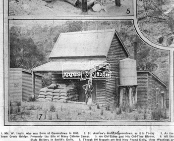
Photograph, Queenstown - St. Andrews District. "Quartz awaiting crushing at the State Battery in Smith's Gully.", c.1929
"The State Battery was the central component in the gold mining of this area from the 1920s. The battery crushed the gold bearing quartz extracted from the mines and was a sizeable weatherboard building enclosing the engine and stampers. All that now remains are the bases for the machinery that comprised the battery, one timber and a couple of concrete bases and the nearby dam, which supplied water. However the historic significance of the site remains and is enhanced by the Queenstown Cemetery on the other side of Smiths Gully Road". - Bick Study 1922 This site is now the Peter Franke Reserve and is managed by Parks Victoria Photo Source: The Leader, Nov. 2nd, 1929This photo forms part of a collection of photographs gathered by the Shire of Eltham for their centenary project book,"Pioneers and Painters: 100 years of the Shire of Eltham" by Alan Marshall (1971). The collection of over 500 images is held in partnership between Eltham District Historical Society and Yarra Plenty Regional Library (Eltham Library) and is now formally known as the 'The Shire of Eltham Pioneers Photograph Collection.' It is significant in being the first community sourced collection representing the places and people of the Shire's first one hundred years.Digital imagesepp, shire of eltham pioneers photograph collection, queenstown, st andrews, gold mining, smiths gully -
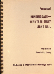 Melbourne Tram Museum
Document - Report, Melbourne & Metropolitan Tramways Board (MMTB), "Proposed Huntingdale - Ferntree Gully Light Rail - Preliminary Feasibility Study", Dec. 1982
Report -A4 bound with brown comb binder, 35 pages + fawn with clear plastic covers, titled "Proposed Huntingdale - Ferntree Gully Light Rail - Preliminary Feasibility Study", dated Dec. 1982. Has a Table of Contents - includes transport proposal, patronage estimates, existing bus services, service levels, costs, financial evaluation and Community Assessment (Cost - Benefit study), maps. Says more detailed work would be required. Not all sheets scannedtrams, tramways, huntingdale, ferntree gully, proposals, new tramways, passengers, surveys -
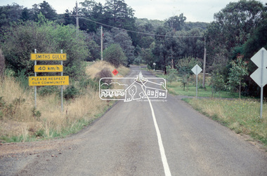 Eltham District Historical Society Inc
Slide - Photograph, Smiths Gully Road, Smiths Gully, c.1993
35mm colour positive transparency Mount - Black and Whiteinfrastructure, joyce road, roads, smiths gully, smiths gully road -
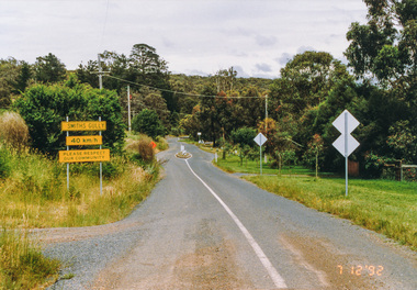
 Eltham District Historical Society Inc
Photograph, Intersection of Spanish Gully Road and Clintons Road, Smiths Gully, c.Oct 1982, 1982
Colour photograph1982, clintons road, long gully, smiths gully, spanish gully road, watsons creek, streets -
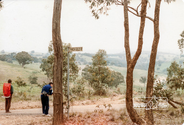
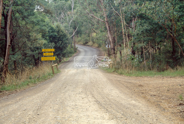
 Eltham District Historical Society Inc
Photograph, Smiths Gully Road looking west near Joyce Road, Smiths Gully, 7 December 1992, 07/12/1992
The Eltham Horse Trail: Research and Warrandyte to Kinglake: Survey of proposed route, December 1992: (3) Kangaroo Ground to KinglakeColour photographeltham horse trail (1992 survey), smiths gully, joyce road, smiths gully road -
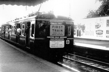 Surrey Hills Historical Society Collection
Photograph, Leaving Surrey Hills - the rear of first electric surburban train to Belgrave, 1962, 18/02/1962
This was a special run for rail enthusiasts and marked the official opening of the first train from Ferntree Gully to Belgrave after the line from Upper Ferntree Gully was converted to broad gauge and electrified.A black and white photograph of the rear of a train with passengers alighting at Surrey Hills station. Signage on the rear indicates that the train was a special excursion marking the electrification of the rail from Ferntree Gully to Belgrave.A sign at the rear of the train states: "First train / Sunday February 18 / Special Excursion / Ferntree Gully Belgrave / Electrification"surrey hills, transport, trains, railways, rail electrification, special rail excursions, official opening -
 Victorian Interpretive Projects Inc.
Photograph - Colour, Clare Gervasoni, Drystone Wall, Hepburn Springs, 2006, 247/08/2006
Colour photograph showing a drystone wall along Doctor's Gully in Hepburn Springs. This land was associated with Vincenzo Perini.drystone, perini, doctor's gully, hepburn, hepburn springs -
 Eltham District Historical Society Inc
Photograph - Digital Photograph, Alan King, Queenstown Cemetery, Smiths Gully Road, St Andrews, 28 December 2007
The discovery of gold in Smyth's Creek in 1854 and subsequent gold rush to the Caledonia diggings led to the establishment of Queenstown (present day St Andrews). The first recorded burial was July 31st, 1861 and it was officially declared a Cemetery Reserve in 1866. Many graves are unmarked and unrecorded including many Chinese and other itinerant miners. The cemetery was closed for new burials in 1851. The last recorded burial was in 1981 in an existing family grave. In Loving memory of David Band Died 30th Decr. 1862, aged 51 years. John Cork Knell Died 11th April 1867, aged 42 years. Eliza Smith Died 20th Jany. 1874, aged 3 1/2 years. William Band Died 20th Feby. 1883, aged 51 years. Published: Nillumbik Now and Then / Marguerite Marshall 2008; photographs Alan King with Marguerite Marshall.; p73 The discovery of gold at Smyth’s Creek* in 1854 brought 3000 people to the area in search of their fortunes.1 However in the harsh conditions many miners and their families died young, and were buried in unmarked graves. Their stories died with them but by 1861, the first burial was recorded at the Queenstown Cemetery – that of William Dalrymple aged 65 – although the cemetery was only officially declared a reserve in 1866. Even before this in 1856, a double burial had been recorded for the twin baby daughters of George Harrison at Market Square, the miners’ settlement – presumably where the cemetery is today. In 1951 the Queenstown Cemetery at 70 Smiths Gully Road, Smiths Gully, closed for burials. However the last burial in a family plot, that of Grace Evelyn Smith, occurred in 1981. Today only 55 headstones remain, but more than 380 burials are recorded. Remnant bushland dominates the cemetery where many graves are merely mounds and others have been damaged by vandalism and the neglect of time. Bushfire in 1962 destroyed the picket fencing, grave markers and cypress boundary planted in the early 1900s. The box/stringybark woodland in the 1.7 hectare Cemetery Reserve is regrowth from then and the indigenous and heritage vegetation is protected. Thanks to the volunteer Cemetery Trust and Friends & Relations of Queenstown Cemetery, the cemetery is maintained, stories recorded and the burial index corrected and expanded.2 Close by the cemetery on the site of today’s Peter Franke Picnic and Nature Reserve stood Market Square, the Caledonia Diggings village of tents and stores, the forerunner of Queenstown, now St Andrews. Many of the Caledonia Diggings miners were Chinese, many of whom, with itinerant prospectors, were buried in unmarked graves. Histories are being recorded of other immigrants, mainly English and German, who settled after the gold rush, some of whose descendants fought and died in the two world wars. Names on many headstones are also recorded on the district’s roads, reserves and war memorials such as Motschall, Joyce, Howard and Coutie. The oldest surviving tombstone is that of Scot, David Band who died in 1862 at 51 years. His oldest daughter Elizabeth, with husband John Knell, owned the Queenstown Hotel and the post office. Child-rearing in a colonial gold town was often tragically difficult, as demonstrated in the first 20 years, when 41% of the 34 burials recorded were children. Settlers endured harsh conditions graphically illustrated with the deaths of Annie Joyce at 30 years and of her family. Annie was married to gold miner Walter Joyce. Their third child Walter, born in 1886, died in March 1887. Eight months later Annie died of breast cancer. Walter died in 1909, aged 53, of miner’s phthisic caused by stone dust destroying his lungs. It was so hard to make a living that burials were usually held from 2.30 pm to allow mourners to work a day before paying their last respects.3 Most burials before 1890 were recorded as Anglicans, as the only church on the Caledonia Diggings was the Church of St Andrew, until 1897, when the Primitive Methodist Church came to Panton Hill. Generally miners came to better themselves, but some, like Grace Hopkinson (nee Milward), born in England in 1828, came from a well-off and educated family. According to family legend Grace emigrated with husband William, to live in a tent, but had kept her personally embossed sterling silver cutlery service. Amid the tough environment were some successes like that reported in The Evelyn Observer April/May 1901 of miner William Hopkinson who was buried at the cemetery in 1912 aged 81. The Observer stated that Hopkinson ‘recently dropped across another find in his claim at One Tree Hill’. The lump of gold found this time weighed more than half a kilo. Mr Hopkinson referred to it as ‘another little speck’. *Today’s Smiths GullyThis collection of almost 130 photos about places and people within the Shire of Nillumbik, an urban and rural municipality in Melbourne's north, contributes to an understanding of the history of the Shire. Published in 2008 immediately prior to the Black Saturday bushfires of February 7, 2009, it documents sites that were impacted, and in some cases destroyed by the fires. It includes photographs taken especially for the publication, creating a unique time capsule representing the Shire in the early 21st century. It remains the most recent comprehenesive publication devoted to the Shire's history connecting local residents to the past. nillumbik now and then (marshall-king) collection, david band, eliza smith, gravestones, john cork knell, queenstown cemetery, smiths gully road, st andrews, william band -
 Bendigo Historical Society Inc.
Archive - MCCOLL, RANKIN AND STANISTREET COLLECTION: SOUTH WATTLE GULLY COMPANY N/L - MINING BOX, 1930's
Mining Box. Metal box painted dark blue with South Wattle Gully painted in white on the front. Formerly box number 479 - now South Wattle Gully Mining Box 15. Tag affixed to front 'box 479'. Box contains various documents relating to South Wattle Gully Mine. Documents are individually catalogued within the box.South Wattle Gullymining, business, mining box 15, mccoll, rankin & stanistreet, south wattle gully company n/l, gold mining, mining box -
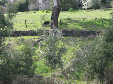
 Ringwood and District Historical Society
Photograph, View up the gully from Glenvale Road, North Ringwood towards the spot of the wall of Loughnan's Lake was
The brown undergrowth is on the remains of the walls, since levelled. Circa 1979. Part of a 51-photo record of the development of the "Kubis" Estate, Ringwood North, including road works to Debbie Place, Kubis Drive, Werac Drive, Manuelo Drive, Iluka Place and Glenvale Road. From the Jack Lundy Clarke collection. -
 Ringwood and District Historical Society
Photograph, Looking east up the gully over the intersection of Werac and Kubis Drives, North Ringwood, in February 1978
E546 N3 Part of a 51-photo record of the development of the "Kubis" Estate, Ringwood North, including road works to Debbie Place, Kubis Drive, Werac Drive, Manuelo Drive, Iluka Place and Glenvale Road. From the Jack Lundy Clarke collection. -
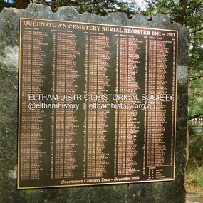 Eltham District Historical Society Inc
Photograph, Jim Connor, Queenstown Cemetery Burial Register 1861-1981, Queenstown Cemetery, Smiths Gully Road, St Andrews, 8 March 2023
Installed by the Queenstown Cemetery Trust December 2009 The discovery of gold in Smyth's Creek in 1854 and subsequent gold rush to the Caledonia diggings led to the establishment of Queenstown (present day St Andrews). The first recorded burial was July 31st, 1861 and it was officially declared a Cemetery Reserve in 1866. Many graves are unmarked and unrecorded including many Chinese and other itinerant miners. The cemetery was closed for new burials in 1851. The last recorded burial was in 1981 in an existing family grave.jim connor collection, 2023-03-08, queenstown cemetery, smiths gully road, st andrews -
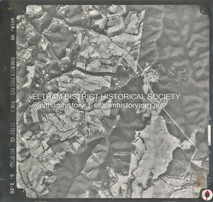 Eltham District Historical Society Inc
Photograph - Aerial Photograph, Smiths Gully, Christmas Hills, St Andrews, Kinglake National Park, 6 Mar. 1986
Small scale Red arrow indicates Northshire of eltham archives, aerial photo, christmas hills, kinglake national park, smiths gully, st andrews -
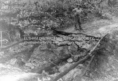 Eltham District Historical Society Inc
Album - Photograph, J.A. McDonald, Black Cameron Road, Smiths Gully, Aug. 1962
Black Cameron Road Bridge over Salters Rush Creek following bush fires 15-16 Jan. 1962Record of various Shire of Eltham infrastructure works undertaken during the period of 1952-1962 involving bridge and road reconstruction projects, sometimes with Eltham Shire Council Project Reference numbers quoted. It was during this period that a number of significant improvements were made to roads and new bridges constructed within the shire that remain in place as of present day (2022). In many situations, the photos provide a tangible visible record of infrastructure that existed throughout the early days of the Shire. The album was put together by or under the direction of the Shire Engineer, J.A. McDonald.H941 stamped on reverse (film processing #)infrastructure, shire of eltham, bridge construction, road construction, 1962-08, bushfires, victorian bushfires - 1962, black cameron road, smiths gully -
 Eltham District Historical Society Inc
Slide - Photograph, Unidentified location, Smiths Gully, 1993
35mm colour positive transparency Mount - Black and Whiteunidentified, infrastructure, streets, roads, smiths gully -
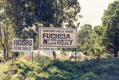 Eltham District Historical Society Inc
Slide - Photograph, Watery Gully Park Fuchsia Nursery, Wattle Glen, c.May 1988
35mm colour positive transparency (1 of 25) Mount - Kodak EktachromeProcess Date MAY 88Mwatery gully park fuchsia nursery, wattle glen, fuchsia nursery, watery gully park