Showing 259 items
matching gutters
-
 Ballarat Tramway Museum
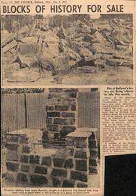
Newspaper, The Courier Ballarat, "Blocks of History for Sale", 3/02/1975 12:00:00 AM
Newspaper cutting from The Courier, 3/2/1975, titled "Blocks of History for Sale", about the sale of blue stone pitchers from Ballarat gutters being made for sale on 8/2/1975 at Victoria Park by the City of Ballaarat.city of ballaarat, sales materials, victoria park -
 Clunes Museum
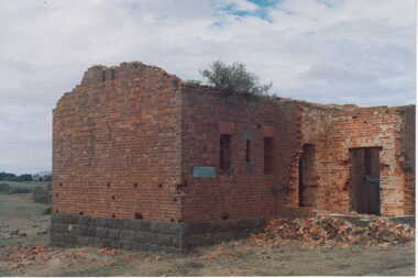
Photograph
COLOURED PHOTOGRAPH BRICK BUILDING WITH BLUESTONE FOUNDATIONS-IN STATE OF DISREPAIR. ROOF DOORS & WINDOWS MISSING, SMALL PILE OF BRICK RUBBLE AT FRONT DOOR.--BUILDING COULD BE REMAINS OF POWDER MAGAZINE NEAR BIRCH'S CREEK. BOXTHORN GROWING IN GUTTERING.local history, photography, photographs, mining, powder magazine -
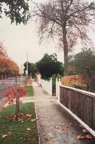
 Kew Historical Society Inc
Photograph - Carson Street, Kew, 1993
A series of five photographs of streetscapes in Kew in 1993, of which this is one, focus on footpaths and gutters, so while the provenance is uncertain, it is presumed that they were created in the office of City Engineer in the City of Kew.Colour positive print of Carson Street, which runs between Studley Park Road and Findon Crescent, dating from 1993carson street -- kew (vic.) -
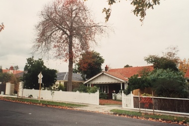
 Kew Historical Society Inc
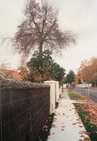
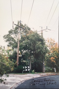
Photograph - Corner of Hodgson and Young Streets, Kew, 1993
A series of five photographs of streetscapes in Kew in 1993, of which this is one, focus on footpaths and gutters, so while the provenance is uncertain, it is presumed that they were created in the office of City Engineer in the City of Kew.Colour positive print of the corner of Hodgson and Young Streets, Kew, dating from 1993."Corner Hodgson & Young Streets"hodgson street -- kew (vic.), young street -- kew (vic.) -
 Kew Historical Society Inc
Photograph - Carson Street, Kew, 1993
A series of five photographs of streetscapes in Kew in 1993, of which this is one, focus on footpaths and gutters, so while the provenance is uncertain, it is presumed that they were created in the office of City Engineer in the City of Kew.Colour positive print of Carson Street, Kew, dating from 1993.carson street -- kew (vic.) -
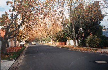 Kew Historical Society Inc
Photograph - Street view, Kew, 1993
A series of five photographs of streetscapes in Kew in 1993, of which this is one, focus on footpaths and gutters, so while the provenance is uncertain, it is presumed that they were created in the office of City Engineer in the City of Kew.Colour positive print of a street in Kew, dating from 1993.streets -- kew (vic.) -
 Kew Historical Society Inc
Photograph - Carson Street, Kew, 1993
A series of five photographs of streetscapes in Kew in 1993, of which this is one, focus on footpaths and gutters, so while the provenance is uncertain, it is presumed that they were created in the office of City Engineer in the City of Kew.Colour positive print of Carson Street in Kew, dating from 1993. Carson Street runs between Studley Park Road and Findon Crescent.carson street -- kew (vic.) -
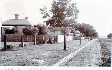 Sunbury Family History and Heritage Society Inc.
Photograph - Evans Street, Sunbury, c1900s
The photograph shows a picture of Evans Street Sunbury taken from the T intersection at Macedon Street and looking south. When the photograph was taken it was one of Sunbury's main residential areas. Since the 1980s the houses in the image have been demolished and replaced with commercial development. Over the years Evans Street has undergone much change from being a residential strip to being the main commercial hub in Sunbury.A sepia photograph with a white border across the bottom and in post card format of a streetscape with a row of trees growing along the footpath and a number of weatherboard Victorian style double fronted cottages. Both the roadway and footpath are not surfaced and the gutter is lined with stone pavers.EVANS STREETevans street -
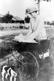 Surrey Hills Historical Society Collection
Photograph - May Palstra and baby Margaret at 60 Guildford Road, Surrey Hills, 1921, 1921
Date is that given by descendant Julia Thornton. William Ernest Palstra married May Aurunui Holdaway (1885-1964) in 1920; this was their first and only home. They had 3 children, Margaret, Jocelyn and William. The family were connected with the Canterbury Salvation Army Corps. William's father was a Salvation Army officer; he spent his early life in South Africa. Prior to marriage he lived in Middlesex Road, Surrey Hills. He was an air force officer. He joined the RAAF in 1925. The family was in London when William was killed on the maiden flight of the Airship R101 to Karachi. It crashed near Beauvais in France. His widow and children returned to live at 60 Guildford Road, Surrey Hills. The donor Margaret Thornton was a daughter of William and May Palstra; one of her daughters, Julia Thornton still lives in the house in 2023. The houses across the road were demolished in the 1970s to build the Surrey Hills Salvation Army Church.This home is one of very few in the area which has been continuously owned by the same family over 3 generations. It is the only known image of the homes purchased and demolished by the Surrey Hills Salvation Army Church.Black and white photo of May Palstra with a baby, identified as Margaret, in a cane pram and with her fox terrier dog on the nature strip in front of her home. In the background can be seen the houses across the road. The road is unmade and the gutters are of bluestone construction.may palstra, margaret palstra, margaret thornton, julia thornton, may aurunui holdaway, guildford road, surrey hills, canterbury salvation army corps, demolished houses, babies, childhood -
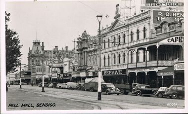 Bendigo Historical Society Inc.
Photograph - BENDIGO - PALL MALL
Photograph - black and white. Photograph of Pall Mall, Bendigo. Written on right hand side No. 22. In the distance you can see shop names like 'Hall and Batchelder', 'Beehive', 'Abbott', 'The Shamrock'. Cafe. many cars parked in the gutter in front of the shops.place, streetscape, pall mall, pall mall bendigo -
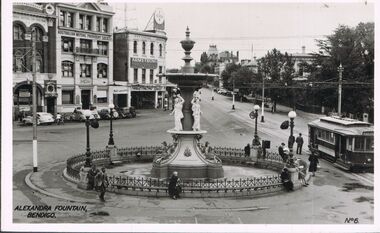 Bendigo Historical Society Inc.
Photograph - BENDIGO - ALEXANDRA FOUNTAIN
Photograph - black and white. Photo of Alexandra Fountain, Bendigo. Right hand corner No.6. Adults sitting/walking around the fountain. Tram right of centre. Left background parked in gutter facing Australian Mutual Provident Society building. Armstrong signage.place, bendigo, view over alexandra fountain, alexandra fountain, bendigo. -
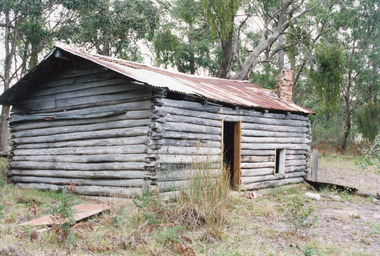 Lakes Entrance Historical Society
Photograph - Log Cabin, 1999
As story goes - An Italian migrant ? Ianuzzi built the cabin as a home for himself and prospective bride, she declined the offer, he made a living growing vegetables, which he sold, but a generous man who gave away just as much.Colour photograph of a log cabin bush hut situated at Harrisons Track, Colquhoun, showing rustic dwelling, rusting corrugated iron roof without guttering, small door and window on side, top of brick chimney through roof. Lakes Entrance Victoriacabin, buildings -
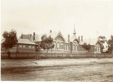 Stawell Historical Society Inc
Photograph, Stawell Primary School Number 502 showing the Front of Building, Bell Tower & Bluestone pitchers for the Road Kerbing
Stawell Primary School 502 - Very early photo with timber picket fence. Three trees growing inside fence. Stone pitchers form guttering. One person standing near fence on left of photo.stawell education -
 Surrey Hills Historical Society Collection
Photograph, Streetscape near the corner of Victoria Crescent and Hotham Street, Surrey Hills
Prior to subdivision for housing this area was paddocks used for grazing of cattle and used as part of the course in the early days of the Surrey Hills Golf Club. Reproduced by permission of Mr John Arnold from his book: "The Riversdale Golf Club - a history, 1892-1977." Copyright to book: Riversdale Golf Club. Surrey Hills Golf Club operated from 1892-1908 then moved and became Riversdale Golf Club. The game was played across paddocks from Trafalgar Street, Mont Albert to Whitehorse Road and down Victoria Crescent to where Box Hill TAFE is now located in Elgar Road. There were problems with cows eating the tee flags! The clubhouse still exists as 30 Trafalgar Street.Black and white photo taken from the centre of a bitumen road which is flanked by bluestone guttering. Nature strips, drive cross-overs and house fences are shown. Trees on the RHS nature strip are pollarded to avoid overhead power and telephone lines. There houses in the background."Bottom: The same view today taken from the intersection of Victoria Crescent and Hotham Street, Surrey Hills."surrey hills golf club, hotham street, victoria crescent, riversdale golf club, surrey hills, john arnold -
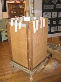 Harcourt Valley Heritage & Tourist Centre
Coolgardie safe, 1925
A pioneering response to the problem of preservation of foodstuffs in hot climatesA timber framed hessian covered cabinet with metal tray at the top and metal guttering cooled by the evaporation of water. Used to preserve cheese, butter, cream and meat and to set jellies. Invented circa 1900 at Coolgardie, W.A. and was in use until electric refrigeration became available. -
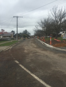 Victorian Interpretive Projects Inc.
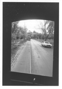
Photograph - Colour, Clare Gervasoni, Kerb and Channelling at Armstrong Street South, Ballarat, 1916, 24/03/2016
A number of colour photographs showing concrete kerb and channeling at Armstrong Street South, Ballarat, taken from South Street. Although in an heritage overlay, the kerb and channeling changed the heritage feel of the block. Some photos show original bluestone gutters that were not destroyed during the process.armstrong street south, south street, ballarat, kerb and channelling, roadworks, bluestone gutters -
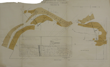 Federation University Historical Collection
Plan, Underground Workings New Australasian Company Creswick, not dated
A plan of the underground working of the New Australasian Mine at Creswick, showing Wheeler's Bridge Road, a transverse section on the West Main Reef Drive and Line AB. It als shows the locations of the Red streak or Australasian Gutter, Reef wash, Eastern Wash, Australasian and Eaglehawk Shaft and prospecting drives.mining, plans, cgt, creswick, new australasian company, wheeler's bridge, red streak gutter, australasian gutter, reef wash, eastern wash, australiasian shaft, eaglehawk shaft -
 Bendigo Historical Society Inc.
Photograph - LITTLE 180 MINE, 1920
black and white photo: street scene, blue stone gutter, wooden electricity pole, adult female standing on road, middle distance. In background, poppet legs, tall chimney, building At left. Striped pole in centre. On back of photo ' Main street Bendigo, leading to mine/1920 'cottage, miners -
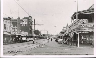 Bendigo Historical Society Inc.
Photograph - MITCHELL STREET BENDIGO
Photograph - black and white. Photo of Mitchell Street, right hand side Bendigo Kozy Korner Café, Photo No.5. Small convertible car parked in gutter to the right. Vehicle with white canopy and men unloading goodsto the left. Peters Ice Cream sign bottom right corner.place, streetscape, mitchell street, bendigo, mitchell street bendigo. -
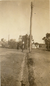
 Ballarat Tramway Museum
Photograph - View of Wendouree Parade north end, c1977
Photograph from the window of a tram (possibly No. 28) looking along the BTPS track from St Aidans Drive with another tramcar in the distance. Shows the roadside nature of gardens area at the time - long grass and before the construction of a gutter and paths. Possibly taken at the same time as item 9642.Yields information about Wendouree Parade near St Aidans Drive.Black and white print on Kodak paper.tramcars, trams, btps, tram 26, tram 28, st aidans drive, wendouree parade -
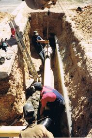 Bendigo Historical Society Inc.
Photograph - CASTLEMAINE GAS COMPANY COLLECTION: PHOTO EXCAVATION
3 workers down in a trench putting pipe into correct alignment and welding together, ladder to left, 2 hand tools near ladder on left, man at bottom foreground is wearing a welding eye shield, man holding the sling which is attached to an overhead excavator, left edge of trench shows street guttering.Kodakorganisation, industry, gas and fuel -
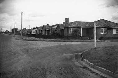 Stawell Historical Society Inc
Photograph, Housing Commission House in Dawson Street -- Photo & Newspaper Clipping
The first Housing Commission homes of brick and tiled roof built after WW2 in Stawell Dawson Street c 1950's. Also in the file a Newspaper clipping from News, Saturday, October 11. 1947. "George Mitchell Square" the first Housing Commission homes built in Stawell. George Mitchell was a member of Borough Council for 40 years and Mayor for 4 years. The housing estate was named in his honor. The architects "Buchannan Laird & Buchanan Geelong.Black and white photograph of a street scene. The photograph shows a line of brick houses along the street with timber fences. Four electric power lines are along the street with 2 in the distance. The street also has curb and guttering. The street to the right has a street post with "George Mitchell St" written on the street sign.stawell -
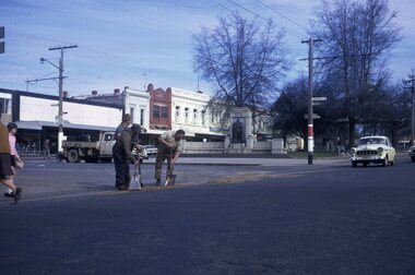 Ballarat Tramway Museum
Slide - 35mm slide/s, Peter Moses, Aug. 1971
Photo of three SEC employees undertaking road surface repairs at the corner of Doveton and Sturt St Ballarat. Photo shows the west bound track and the monument to King George V. In the background, parked against the median strip gutter is the SEC's truck. Kodak cardboard mount slide, taken by Peter Moses August 1971.On back of slide in blue ink "Ballarat / Men working Sturt St." and on the bottom edge in black ink "P. Moses".tramways, trams, sturt st, doveton st, employees, track repairs, road works, king george v monument -
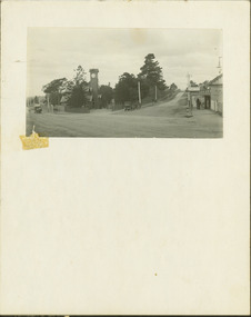 Kew Historical Society Inc
Photograph - Entrance to the Boroondara General (Kew) Cemetery, E.J. Dower, 1913
One of a series of photographs, taken by Edgar James Dower in the second decade of the twentieth century. Born and raised in Olinda, his family later moved to Surrey Hills. He worked as an adult as a clerk in the city office of the Metropolitan Gas Company, and in his role as a 'collector', he was able to photograph scenes including the construction of tramlines and associated buildings in Kew, Hawthorn, Camberwell and Surrey Hills. Later he established a real estate agency with his brother - the E.J. Dower Real Estate Agency, Dandenong Office.The image is an historically significant record of the development of transport infrastructure which was used to connect Victorians in the first two decades of the twentieth century. This development resulted from increases in population and the consequent extension of Melbourne's suburbs. The photographs, both individually and collectively, richly detail the labour of workers and the tools and machinery used to create and extend Melbourne's tram network in the years preceding and during World War 1.Digital copy of an original mounted photograph showing the entrance to the Boroondara General (Kew) Cemetery in 1913. The entrance was/is on the corner of High Street and Parkhill Road. The horse drawn tram from Victoria Street Bridge to the Cemetery can be seen to the left of the photo in High Street. Note also the extensive bluestone gutters in Parkhill Road.Annotated verso: "Entrance to Kew Cemetery? / 1913"theme --- travelling by tram, theme -- connecting victorians by transport and communications, trams -- kew (vic.), high street. -- kew (vic.), parkhill road -- kew (vic.) -
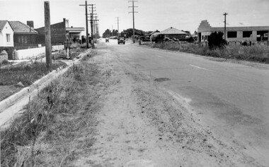 City of Kingston
Photograph - Black and white, c. 1950
While the road is sealed, there is evidence of potholes that have been filled, and the wide, gravel shoulder has long grass running into the gutter of the nature strip. On the other side of the road, extremely long grass can be seen growing on the side of the road. There is a truck visible on the road, which indicates the rural nature of the Cheltenham community in the 1950s.This image is one of many in the collections that focuses on the railway or roads. The development of roads and the railway was crucial to the ongoing development of the area. Black and white photograph of the intersection of Warrigal and Centre Dandenong roads, Cheltenham. On the left hand side is a small sign warning of a cross roads intersection. Housing and shops line the road.Handwritten in blue ink on reverse: 219 Handwritten in red ink on reverse: 80%cheltenham, roads, suburbs -
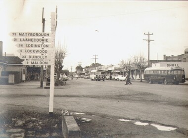 Bendigo Historical Society Inc.
Photograph - HIGH STREET, KANGAROO FLAT, c1961
Black and white photograph: Street-scape High Street, Kangaroo Flat 1961. View of shops in the main block. Sign post far left with distances un miles. Buses, cars and pedestrians. Note no formed gutters. Shell Petrol Station on right. Photographed from the corner where Aldi's super market now stands.The Herald & Weekly Times Ltd. Melbourne, Australiaplace, streetscape, high strret, kangaroo flat, copyright, not for unauthorized reproduction -
 Bendigo Historical Society Inc.
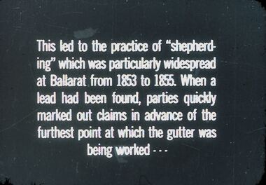
Slide - DIGGERS & MINING. GETTING THE GOLD, c1853
Diggers & Mining. Getting the Gold. Slide: This led to the practice of ''shepherding'' which was particularly widespread at Ballarat from 1853 to 1855. When a lead had been found, parties quickly marked out claims in advance of the furthest point at which the gutter was being worked - - - Markings: 51 994.LIF:4. Used as a teaching aid.hanimounteducation, tertiary, goldfields -
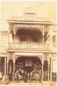 Bendigo Historical Society Inc.
Photograph - BLACK AND WHITE PHOTOGRAPH OF THE 'NEW TIMES' BUILDING OCCUPIED BY ABBOTTS BOOTS AN SHOES
Black and white photograph of the 'New Times' building in Pall Mall, next to myer. The top has a rather ornate masonry design. The lower edge of the guttering of the top verandah and the lower edge of the guttering at floor level of the top floor is a very ornate lacework display.Centre bottom is hitching post for horses. Signage on the building reads Manufacturers of Boots and Shoes, Abbott & Co is also faintly displayed. An adult male, and female standing next to the hitching post. A young man has his right arm draped over the hitching post and two other young people to his right. Two other young boys are standing between two posts on the left side. The business to the left is using two posts to support bags that are ready for sale. A male in white is at the very left of the photo.buildings, commercial, abbotts boot & shoe manufacturers -
 Greensborough Historical Society
Photograph - Digital image, Marilyn Smith et al, Janefield Precinct: World War 2 era concrete and guttering, 27/11/2014
Janefield Precinct: World War 2 era concrete and guttering. The remains of this site are between Greensborough and Janefield. A RAAF Hygiene Training Camp was located on the Plenty River, just south of the Janefield community. It was in use from 1944 to 1946. The Camp was constructed from salvaged materials. Instruction included building and maintenance of grease traps, latrines, elementary plumbing and carpentry.Early remains of a WW2 training camp Digital colour photograph.janefield -
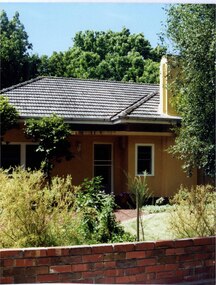 Glen Eira Historical Society
Photograph, Dalny Road, 25, Murrumbeena, 2001
Originally labelled "Beauville Estate, Established 1936, Still Thriving 65 years on, 10th March 2001", the Beauville Estate Album contains colour photographs of houses in the Estate. They were taken around the time of the Beauville Estate’s 65th Heritage Celebration held on 10/03/2001 and donated to the Caulfield Historical Society shortly afterwards. Photographer unknown. City of Glen Eira’s Heritage Management Plan Vol 2 p79 (this is p84 of the pdf version) – HO12 Beauville Estate and environs, Murrumbeena: The Beauville Historic Area is important at the State level as the first large housing estate undertaken by the AV Jennings Construction Co, later Jennings Group Limited, Victoria’s largest home builder. It is important also as a very early estate development incorporating a range of features other than houses and including made roads, shops and recreation facilities. In this respect it was the forerunner of the comprehensively planned housing estate of the post war era. The estate is distinguished by its aesthetic values, as is the earlier and comparable Hillcrest Estate, which are formed by a combination of restrained diversity in house styles, with the exception of no. 30 in the emerging International style, and by a landscaped garden environment. Colour photograph of a light tan rendered brick house with a small curved additional roof jutting over the front door. Other features include tiled roof, white framed windows, door and guttering, feature chimney and a low unpainted variegated brown brick fence in the foreground with bushes and lawn behind the fence. Tall trees behind the house.murrumbeena, houses, architectural styles, 1930's, inter war style, a.v. jennings, av jennings, jennings, brick houses, beauville estate, dalny road, sir albert victor jennings, a v jennings construction co, beauville estate heritage area, glen eira city council, architectural features, jennings group limited, land subdivision, gardens, beauville historic area, rendered houses, chimneys, brick fences