Showing 165 items
matching hectares
-
 Eltham District Historical Society Inc
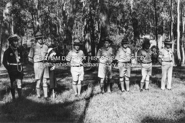
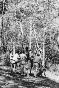
Photograph - Black and White Print, Lewis Tulk, Stage IV Scout Leader Training course, Gillwell Park, Gembrook, Vic, c.1960
Gilwell Park is a campsite and outdoor recreation area located in Gembrook, Victoria, Australia. It is primarily used by the scouting community as a training and camping facility. The site is owned and operated by Scouts Victoria, and is one of the largest and most popular campsites in the state. It covers over 95 hectares of natural bushland, and features a range of facilities including campsites, activity areas, a dining hall, and accommodation options. Gilwell Park has a long history within the scouting movement, and is named after the original Gilwell Park located in Epping Forest, England. The English site is considered the spiritual home of scouting, and was where the first Wood Badge training course was held in 1919. Today, Gilwell Park at Gembrook offers a range of training courses and programs for scouts, leaders, and other community groups. It is also a popular destination for school camps, corporate team-building events, and outdoor enthusiasts looking to explore the natural beauty of the region. [Source: ChatGPT Open AI - Gilwell Park in Australia.. (2023, March 23). Retrieved from https://chat.openai.com/chat] Donated by Lewis Tulk, former Scout Area Training Commisioner for Leaders. Lewis did his training at Gillwell Park in London.On reverse of print, stamped with film no. 6927scouts victoria, gillwell park, gembrook, scout leader training, lewis tulk collection -
 Eltham District Historical Society Inc
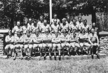
Photograph - Black and White Print, Lewis Tulk, Stage IV Scout Leader Training course, Gillwell Park, Gembrook, Vic, c.1960
Gilwell Park is a campsite and outdoor recreation area located in Gembrook, Victoria, Australia. It is primarily used by the scouting community as a training and camping facility. The site is owned and operated by Scouts Victoria, and is one of the largest and most popular campsites in the state. It covers over 95 hectares of natural bushland, and features a range of facilities including campsites, activity areas, a dining hall, and accommodation options. Lewis Tulk centre front Gilwell Park has a long history within the scouting movement, and is named after the original Gilwell Park located in Epping Forest, England. The English site is considered the spiritual home of scouting, and was where the first Wood Badge training course was held in 1919. Today, Gilwell Park at Gembrook offers a range of training courses and programs for scouts, leaders, and other community groups. It is also a popular destination for school camps, corporate team-building events, and outdoor enthusiasts looking to explore the natural beauty of the region. [Source: ChatGPT Open AI - Gilwell Park in Australia.. (2023, March 23). Retrieved from https://chat.openai.com/chat] Donated by Lewis Tulk, former Scout Area Training Commisioner for Leaders. Lewis did his training at Gillwell Park in London.On reverse of print, stamped with film no. 6927scouts victoria, gillwell park, gembrook, scout leader training, lewis tulk collection -
 Eltham District Historical Society Inc
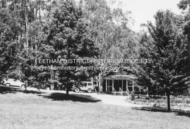
Photograph - Black and White Print, Lewis Tulk, Original Training Hut, Gillwell Park, Gembrook, Vic, c.1960
Gilwell Park is a campsite and outdoor recreation area located in Gembrook, Victoria, Australia. It is primarily used by the scouting community as a training and camping facility. The site is owned and operated by Scouts Victoria, and is one of the largest and most popular campsites in the state. It covers over 95 hectares of natural bushland, and features a range of facilities including campsites, activity areas, a dining hall, and accommodation options. Gilwell Park has a long history within the scouting movement, and is named after the original Gilwell Park located in Epping Forest, England. The English site is considered the spiritual home of scouting, and was where the first Wood Badge training course was held in 1919. Today, Gilwell Park at Gembrook offers a range of training courses and programs for scouts, leaders, and other community groups. It is also a popular destination for school camps, corporate team-building events, and outdoor enthusiasts looking to explore the natural beauty of the region. [Source: ChatGPT Open AI - Gilwell Park in Australia.. (2023, March 23). Retrieved from https://chat.openai.com/chat] Donated by Lewis Tulk, former Scout Area Training Commisioner for Leaders. Lewis did his training at Gillwell Park in London.On reverse of print, stamped with film no. 6927scouts victoria, gillwell park, gembrook, scout leader training, lewis tulk collection -
 Eltham District Historical Society Inc
Photograph - Black and White Print, Lewis Tulk, Stage IV Scout Leader Training course, Gillwell Park, Gembrook, Vic, c.1960
Gilwell Park is a campsite and outdoor recreation area located in Gembrook, Victoria, Australia. It is primarily used by the scouting community as a training and camping facility. The site is owned and operated by Scouts Victoria, and is one of the largest and most popular campsites in the state. It covers over 95 hectares of natural bushland, and features a range of facilities including campsites, activity areas, a dining hall, and accommodation options. Gilwell Park has a long history within the scouting movement, and is named after the original Gilwell Park located in Epping Forest, England. The English site is considered the spiritual home of scouting, and was where the first Wood Badge training course was held in 1919. Today, Gilwell Park at Gembrook offers a range of training courses and programs for scouts, leaders, and other community groups. It is also a popular destination for school camps, corporate team-building events, and outdoor enthusiasts looking to explore the natural beauty of the region. [Source: ChatGPT Open AI - Gilwell Park in Australia.. (2023, March 23). Retrieved from https://chat.openai.com/chat] Donated by Lewis Tulk, former Scout Area Training Commisioner for Leaders. Lewis did his training at Gillwell Park in London.On reverse of print, stamped with film no. 6927scouts victoria, gillwell park, gembrook, scout leader training, lewis tulk collection -
 Eltham District Historical Society Inc
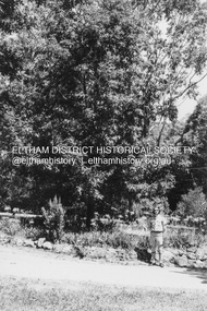
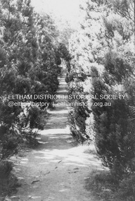
Photograph - Black and White Print, Lewis Tulk, Stage IV Scout Leader Training course, Gillwell Park, Gembrook, Vic, c.1960
Avenue of trees leading up to Chapel Gilwell Park is a campsite and outdoor recreation area located in Gembrook, Victoria, Australia. It is primarily used by the scouting community as a training and camping facility. The site is owned and operated by Scouts Victoria, and is one of the largest and most popular campsites in the state. It covers over 95 hectares of natural bushland, and features a range of facilities including campsites, activity areas, a dining hall, and accommodation options. Gilwell Park has a long history within the scouting movement, and is named after the original Gilwell Park located in Epping Forest, England. The English site is considered the spiritual home of scouting, and was where the first Wood Badge training course was held in 1919. Today, Gilwell Park at Gembrook offers a range of training courses and programs for scouts, leaders, and other community groups. It is also a popular destination for school camps, corporate team-building events, and outdoor enthusiasts looking to explore the natural beauty of the region. [Source: ChatGPT Open AI - Gilwell Park in Australia.. (2023, March 23). Retrieved from https://chat.openai.com/chat] Donated by Lewis Tulk, former Scout Area Training Commisioner for Leaders. Lewis did his training at Gillwell Park in London.On reverse of print, stamped with film no. 6927scouts victoria, gillwell park, gembrook, scout leader training, lewis tulk collection -
 Eltham District Historical Society Inc
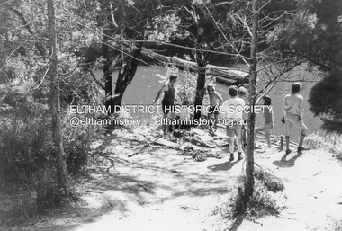
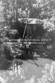
Photograph - Black and White Print, Lewis Tulk, Stage IV Scout Leader Training course, Gillwell Park, Gembrook, Vic, c.1960
Water activies at dam on site Gilwell Park is a campsite and outdoor recreation area located in Gembrook, Victoria, Australia. It is primarily used by the scouting community as a training and camping facility. The site is owned and operated by Scouts Victoria, and is one of the largest and most popular campsites in the state. It covers over 95 hectares of natural bushland, and features a range of facilities including campsites, activity areas, a dining hall, and accommodation options. Gilwell Park has a long history within the scouting movement, and is named after the original Gilwell Park located in Epping Forest, England. The English site is considered the spiritual home of scouting, and was where the first Wood Badge training course was held in 1919. Today, Gilwell Park at Gembrook offers a range of training courses and programs for scouts, leaders, and other community groups. It is also a popular destination for school camps, corporate team-building events, and outdoor enthusiasts looking to explore the natural beauty of the region. [Source: ChatGPT Open AI - Gilwell Park in Australia.. (2023, March 23). Retrieved from https://chat.openai.com/chat] Donated by Lewis Tulk, former Scout Area Training Commisioner for Leaders. Lewis did his training at Gillwell Park in London.On reverse of print, stamped with film no. 6927scouts victoria, gillwell park, gembrook, scout leader training, lewis tulk collection -
 Eltham District Historical Society Inc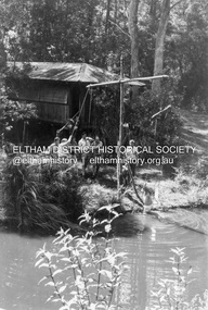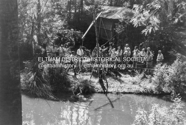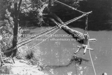
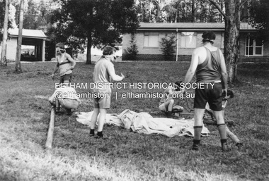
Photograph - Black and White Print, Lewis Tulk, Stage IV Scout Leader Training course, Gillwell Park, Gembrook, Vic, c.1960
Pioneering activity Gilwell Park is a campsite and outdoor recreation area located in Gembrook, Victoria, Australia. It is primarily used by the scouting community as a training and camping facility. The site is owned and operated by Scouts Victoria, and is one of the largest and most popular campsites in the state. It covers over 95 hectares of natural bushland, and features a range of facilities including campsites, activity areas, a dining hall, and accommodation options. Gilwell Park has a long history within the scouting movement, and is named after the original Gilwell Park located in Epping Forest, England. The English site is considered the spiritual home of scouting, and was where the first Wood Badge training course was held in 1919. Today, Gilwell Park at Gembrook offers a range of training courses and programs for scouts, leaders, and other community groups. It is also a popular destination for school camps, corporate team-building events, and outdoor enthusiasts looking to explore the natural beauty of the region. [Source: ChatGPT Open AI - Gilwell Park in Australia.. (2023, March 23). Retrieved from https://chat.openai.com/chat] Donated by Lewis Tulk, former Scout Area Training Commisioner for Leaders. Lewis did his training at Gillwell Park in London.On reverse of print, stamped with film no. 6927scouts victoria, gillwell park, gembrook, scout leader training, lewis tulk collection -
 Eltham District Historical Society Inc
Photograph - Negative, Lewis Tulk, Gillwell Park, Gembrook, Vic, c.May 1957
Gilwell Park is a campsite and outdoor recreation area located in Gembrook, Victoria, Australia. It is primarily used by the scouting community as a training and camping facility. The site is owned and operated by Scouts Victoria, and is one of the largest and most popular campsites in the state. It covers over 95 hectares of natural bushland, and features a range of facilities including campsites, activity areas, a dining hall, and accommodation options. Gilwell Park has a long history within the scouting movement, and is named after the original Gilwell Park located in Epping Forest, England. The English site is considered the spiritual home of scouting, and was where the first Wood Badge training course was held in 1919. Today, Gilwell Park at Gembrook offers a range of training courses and programs for scouts, leaders, and other community groups. It is also a popular destination for school camps, corporate team-building events, and outdoor enthusiasts looking to explore the natural beauty of the region. [Source: ChatGPT Open AI - Gilwell Park in Australia.. (2023, March 23). Retrieved from https://chat.openai.com/chat] Donated by Lewis Tulk, former Scout Area Training Commisioner for Leaders. Lewis did his training at Gillwell Park in London.Print copy stamped "17" on reverselewis tulk collection, scouts victoria, gillwell park, gembrook, scout leader training -
 Department of Energy, Environment and Climate Action
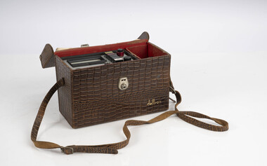
Fuel Mincer
Used to mince fuel samples to measure moisture content Representative samples of fuel such as bark, leaves, twigs etc were minced and the moisture measured The availability of fuel to burn depends largely on its moisture content. When it exceeds 20-25% not much will burn, whereas 12-15% is generally ideal for fuel reduction burning, but if the moisture content drops as low as 7-10% virtually everything will ignite, and fire behaviour becomes extreme. During the afternoon of the Ash Wednesday bushfires on 16 February 1983 fuel moisture contents were recorded at Stawell as low as 2.7%. Fine fuels like leaves and bark can rapidly absorb moisture after a shower of rain, or from the air when the Relative Humidity (RH) is high, and the temperature is low. Conversely, they can also dry out very quickly. So even though the overall fuel quantity in the forest doesn’t change, the fine fuel availability can increase rapidly from zero after rain to many tonnes per hectare as the fuel dries out. This can happen over a few hours on hot and windy days. Heavy fuels like logs on the ground take longer to dry out. Fuel mincer Made at Altona as an alternative design to the commercial Spong Mincer With wooden plug to push fuel into the mincer and glass jar to collect sampleforests commission victoria (fcv), bushfire, forest measurement -
 Department of Energy, Environment and Climate Action
Electric Fuel Mincer
Used to mince fuel samples to measure moisture content Representative samples of fuel such as bark, leaves, twigs etc were minced and the moisture measured The availability of fuel to burn depends largely on its moisture content. When it exceeds 20-25% not much will burn, whereas 12-15% is generally ideal for fuel reduction burning, but if the moisture content drops as low as 7-10% virtually everything will ignite, and fire behaviour becomes extreme. During the afternoon of the Ash Wednesday bushfires on 16 February 1983 fuel moisture contents were recorded at Stawell as low as 2.7%. Fine fuels like leaves and bark can rapidly absorb moisture after a shower of rain, or from the air when the Relative Humidity (RH) is high, and the temperature is low. Conversely, they can also dry out very quickly. So even though the overall fuel quantity in the forest doesn’t change, the fine fuel availability can increase rapidly from zero after rain to many tonnes per hectare as the fuel dries out. This can happen over a few hours on hot and windy days. Heavy fuels like logs on the ground take longer to dry out. Battery operated Fuel mincer. Plugs into 12 volt car cigarette lighter socket Adaption using parts from commercial food processor Made at Altona as an alternative design to the commercial Spong Mincer Glass jar to collect sampleforests commission victoria (fcv), bushfire, forest measurement -
 Department of Energy, Environment and Climate Action
Delton Moisture meter
Used to measure moisture content by electric current resistance Representative samples of fuel such as bark, leaves, twigs etc were minced and the moisture measured The availability of fuel to burn depends largely on its moisture content. When it exceeds 20-25% not much will burn, whereas 12-15% is generally ideal for fuel reduction burning, but if the moisture content drops as low as 7-10% virtually everything will ignite, and fire behaviour becomes extreme. During the afternoon of the Ash Wednesday bushfires on 16 February 1983 fuel moisture contents were recorded at Stawell as low as 2.7%. Fine fuels like leaves and bark can rapidly absorb moisture after a shower of rain, or from the air when the Relative Humidity (RH) is high, and the temperature is low. Conversely, they can also dry out very quickly. So even though the overall fuel quantity in the forest doesn’t change, the fine fuel availability can increase rapidly from zero after rain to many tonnes per hectare as the fuel dries out. This can happen over a few hours on hot and windy days. Heavy fuels like logs on the ground take longer to dry out. Commercial timber moisture meter used to measure fuelDCR9-Tforests commission victoria (fcv), bushfire, forest measurement -
 Department of Energy, Environment and Climate Action
Marconi Moisture meter
Used to measure fuel moisture content Representative samples of fuel such as bark, leaves, twigs etc were minced and the moisture measured The availability of fuel to burn depends largely on its moisture content. When it exceeds 20-25% not much will burn, whereas 12-15% is generally ideal for fuel reduction burning, but if the moisture content drops as low as 7-10% virtually everything will ignite, and fire behaviour becomes extreme. During the afternoon of the Ash Wednesday bushfires on 16 February 1983 fuel moisture contents were recorded at Stawell as low as 2.7%. Fine fuels like leaves and bark can rapidly absorb moisture after a shower of rain, or from the air when the Relative Humidity (RH) is high, and the temperature is low. Conversely, they can also dry out very quickly. So even though the overall fuel quantity in the forest doesn’t change, the fine fuel availability can increase rapidly from zero after rain to many tonnes per hectare as the fuel dries out. This can happen over a few hours on hot and windy days. Heavy fuels like logs on the ground take longer to dry out. Adaption of a commercial timber moisture meter measure fuelTF 933 Cforests commission victoria (fcv), bushfire, forest measurement -
 Eltham District Historical Society Inc
Photograph - Digital Photograph, Alan King, Blue Lake, Plenty Gorge Park, 2008
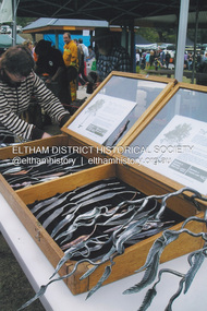
A quarry was transformed into the Blue Lake. Published: Nillumbik Now and Then / Marguerite Marshall 2008; photographs Alan King with Marguerite Marshall.; p179 The dramatic steep-sided Plenty Gorge lies along the divide of two geological areas, and separates the Nillumbik Shire and the City of Whittlesea. On the Nillumbik side are undulating hills and sedimentary rock, and in Whittlesea, lies a basalt plain formed by volcanic action up to two million years ago. This provides the Plenty Gorge Park with diverse vegetation and habitats, making it one of Greater Melbourne’s most important refuges for threatened and significant species. The park, established in 1986, consists of around 1350 hectares, and extends 11 kilometres along the Plenty River, from Greensborough to Mernda. It provides a wildlife corridor for around 500 native plant and 280 animal species. The area’s plentiful food and water attracted the Wurundjeri Aboriginal people and then European settlers. By 1837 squatters had claimed large runs of land for their sheep and cattle. The Plenty Valley was among the first in the Port Phillip District to be settled - mainly in the less heavily timbered west - and was proclaimed a settled district in 1841.But by the late 1880s, the settlers’ extensive land clearing for animal grazing, then agriculture, depleted the Wurundjeri’s traditional food sources, which helped to drive them away. Many Wurundjeri artefacts remain (now government protected), and so far 57 sites have been identified in the park, including scarred trees, burial areas and stone artefacts. Pioneer life could be very hard because of isolation, flooding, bushfires and bushrangers. Following the Black Thursday bushfires of 1851, basalt was quarried to build more fire-resistant homes. Gold discoveries in the early 1850s swelled the population, particularly around Smugglers Gully; but food production made more of an impact. In the late 1850s wheat production supplanted grazing. In the 1860s the government made small holdings available to poorer settlers. These had the greatest effect on the district, particularly in Doreen and Yarrambat, where orchards were established from the 1880s to 1914. Links with a prominent early family are the remains of Stuchbery Farm, by the river’s edge bounded by Smugglers Gully to the north and La Trobe Road, Yarrambat, to the east. The Stuchberys moved to the valley in 1890, and the family still lives in the area. In 1890, Alfred and Ada first lived in a tent where four children were born, then Alfred built the house and outbuildings around 1896. They planted an orchard, then a market garden, and developed a dairy. The family belonged to the local Methodist and tennis communities. Their grandson Walter, opened the Flying Scotsman Model Railway Museum in Yarrambat, which his widow, Vi, continues to run. Wal was also the Yarrambat CFA Captain for 22 years until 1987. Walter sold 24 hectares in 1976 for development - now Vista Court - and in 1990, the remaining 22.6 hectares for the park. Remaining are an early stone dairy and remnants of a stone barn, a pig sty and a well. Until it was destroyed by fire in 2003, a slab hut stood on the Happy Hollow Farm site, at the southern end of the park. The hut is thought to have been built in the Depression around 1893. This was a rare and late example of a slab hut with a domestic orchard close to Melbourne. Emmet Watmough and his family first occupied the hut, followed by a succession of families, until the Bell family bought it around 1948. There they led a subsistence lifestyle for 50 years, despite encroaching Melbourne suburbia. The Yellow Gum Recreation Area includes the Blue Lake, coloured turquoise at certain times of the year. Following the 1957 bushfires, this area was quarried by Reid Quarries Pty Ltd for Melbourne’s first skyscrapers, then by Boral Australia. However in the early 1970s water began seeping into the quarry forming the Blue Lake and the quarry was closed. The State Government bought the site in 1997 and opened it as a park in 1999.This collection of almost 130 photos about places and people within the Shire of Nillumbik, an urban and rural municipality in Melbourne's north, contributes to an understanding of the history of the Shire. Published in 2008 immediately prior to the Black Saturday bushfires of February 7, 2009, it documents sites that were impacted, and in some cases destroyed by the fires. It includes photographs taken especially for the publication, creating a unique time capsule representing the Shire in the early 21st century. It remains the most recent comprehenesive publication devoted to the Shire's history connecting local residents to the past. nillumbik now and then (marshall-king) collection, blue lake, plenty gorge park -
 Eltham District Historical Society Inc
Photograph, Fay Bridge, The Tree Project, 2009
Australia's worst natural disaster, fed by extreme temperatures, tornado-like wind speeds and tinder-dry land, culminated in the disaster we now know as Black Saturday, February 7, 2009. Before the sun would set on the blackest day in Australia's history, thousands of hectares would become blackened landscape and an unparalleled loss of lives could only mean that many areas would never be the same again. To remember the people lost to the devastating Black Saturday fires of 2009 and our brave CFA men and women who battled the elements to protect our towns, the Australian Blacksmiths Association (Victoria) Inc. invited blacksmiths from across the country and around the world to contribute to the creation of a steel gumtree. The Blacksmiths' Tree, as it came to be called, was erected on February 14, 2014. Five years in the making, this 10m high stainless steel and copper tree was forged with love and care by hundreds of blacksmiths across 20 countries. It stands in the township of Strathewen, Victoria, Australia to remember all of those who perished in the Black Saturday fires of 2009, those who fought the fires and those who continue to live their lives with hope and courage. The tree stands at the Peter Avola Memorial Pavilion, 160 Chadds Creek Road, Strathewen, Victoria.fay bridge collection, black saturday, kinglake, victorian bushfires - 2009, the tree project -
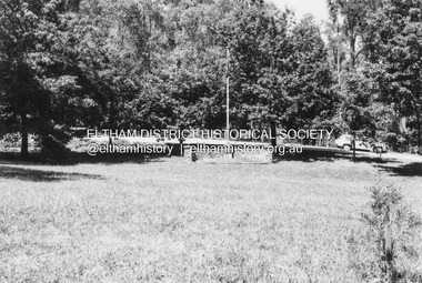 Eltham District Historical Society Inc
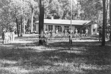
Photograph - Black and White Print, Lewis Tulk, Parade Ground, Gillwell Park, Gembrook, Vic, c.1960
The Parade Ground was where the annual presentations of awards were made. On the right is the little Chapel. Gilwell Park is a campsite and outdoor recreation area located in Gembrook, Victoria, Australia. It is primarily used by the scouting community as a training and camping facility. The site is owned and operated by Scouts Victoria, and is one of the largest and most popular campsites in the state. It covers over 95 hectares of natural bushland, and features a range of facilities including campsites, activity areas, a dining hall, and accommodation options. Gilwell Park has a long history within the scouting movement, and is named after the original Gilwell Park located in Epping Forest, England. The English site is considered the spiritual home of scouting, and was where the first Wood Badge training course was held in 1919. Today, Gilwell Park at Gembrook offers a range of training courses and programs for scouts, leaders, and other community groups. It is also a popular destination for school camps, corporate team-building events, and outdoor enthusiasts looking to explore the natural beauty of the region. [Source: ChatGPT Open AI - Gilwell Park in Australia.. (2023, March 23). Retrieved from https://chat.openai.com/chat] Donated by Lewis Tulk, former Scout Area Training Commisioner for Leaders. Lewis did his training at Gillwell Park in London.On reverse of print, stamped with film no. 6927scouts victoria, gillwell park, gembrook, scout leader training, lewis tulk collection -
 Eltham District Historical Society Inc
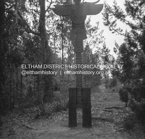
Photograph - Negative, Lewis Tulk, Outdoor Chapel, Gillwell Park, Gembrook, Vic, c.May 1957
Outdoor Chapel, Gilwell Park Scout Association State Training Centre - mainly for leaders Gilwell Park is a campsite and outdoor recreation area located in Gembrook, Victoria, Australia. It is primarily used by the scouting community as a training and camping facility. The site is owned and operated by Scouts Victoria, and is one of the largest and most popular campsites in the state. It covers over 95 hectares of natural bushland, and features a range of facilities including campsites, activity areas, a dining hall, and accommodation options. Gilwell Park has a long history within the scouting movement, and is named after the original Gilwell Park located in Epping Forest, England. The English site is considered the spiritual home of scouting, and was where the first Wood Badge training course was held in 1919. Today, Gilwell Park at Gembrook offers a range of training courses and programs for scouts, leaders, and other community groups. It is also a popular destination for school camps, corporate team-building events, and outdoor enthusiasts looking to explore the natural beauty of the region. [Source: ChatGPT Open AI - Gilwell Park in Australia.. (2023, March 23). Retrieved from https://chat.openai.com/chat] Donated by Lewis Tulk, former Scout Area Training Commisioner for Leaders. Lewis did his training at Gillwell Park in London.Print copy stamped "17" on reverselewis tulk collection, scouts victoria, gillwell park, gembrook, scout leader training -
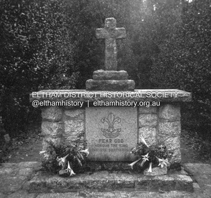
 Eltham District Historical Society Inc
Photograph - Negative, Lewis Tulk, Outdoor Chapel, Gillwell Park, Gembrook, Vic, c.May 1957
At entrance to Chapel Outdoor Chapel, Gilwell Park Scout Association State Training Centre - mainly for leaders Gilwell Park is a campsite and outdoor recreation area located in Gembrook, Victoria, Australia. It is primarily used by the scouting community as a training and camping facility. The site is owned and operated by Scouts Victoria, and is one of the largest and most popular campsites in the state. It covers over 95 hectares of natural bushland, and features a range of facilities including campsites, activity areas, a dining hall, and accommodation options. Gilwell Park has a long history within the scouting movement, and is named after the original Gilwell Park located in Epping Forest, England. The English site is considered the spiritual home of scouting, and was where the first Wood Badge training course was held in 1919. Today, Gilwell Park at Gembrook offers a range of training courses and programs for scouts, leaders, and other community groups. It is also a popular destination for school camps, corporate team-building events, and outdoor enthusiasts looking to explore the natural beauty of the region. [Source: ChatGPT Open AI - Gilwell Park in Australia.. (2023, March 23). Retrieved from https://chat.openai.com/chat] Donated by Lewis Tulk, former Scout Area Training Commisioner for Leaders. Lewis did his training at Gillwell Park in London.Print copy stamped "17" on reverselewis tulk collection, scouts victoria, gillwell park, gembrook, scout leader training -
 Department of Energy, Environment and Climate Action
Relative Humidity Meter
Bushfire behaviour is influenced by many factors including temperature, relative humidity (RH), forest type, fuel quantity and fuel dryness, topography and even slope. Wind has a dominant effect on the Rate of Spread (ROS), as well as fire size, shape and direction. Temperature and relative humidity have major impacts on fuel dryness and therefore upon the availability of fuel for combustion. The amount of fine fuel available can increase rapidly from nearly zero when fuel moisture content is more than 16% after rain or a heavy morning dew, to many tonnes per hectare as fuel dries out later in the day and the moisture content drops below 9%. This explosive escalation in the amount of available fuel can happen over a few hours on hot and windy days. This device is used for determining air temperature and relative humidity. It contains two thermometers, one of which is covered with a wick saturated with ambient temperature liquid water. These two thermometers are called dry bulb and wet bulb. Once the thermometers to reach equilibrium temperatures the two thermometers are quickly read. The figures are then used to convert the dry bulb temperature TDB and the wet bulb temperature TWB into humidity information. The wet bulb temperature is approximately equal to the adiabatic saturation temperature. Relative humidity meter in wooden box two stainless steel tubes contain wet and dry thermometers A small clock drives a fan motor in the base to circulate airforests commission victoria (fcv), weather, bushfire -
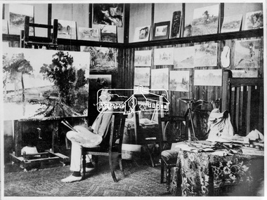 Eltham District Historical Society Inc
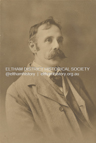
Photograph, Walter Withers in his studio, Eltham, c.1906
Walter Withers (1854-1914) was born in Handsworth, Warwickshire, England. He migrated to Australia in 1882 and in time was to become one of the country's most famous painters. In 1887/8 he spent a year in London and Paris during which time he married Fanny Flinn. When he returned to Melbourne he was engaged by publishers doing black and white illustrations. In the late 1880's he became associated with artists who formed the renowned "Heidelberg School" and in 1890 moved to "Charterisville" at Eaglemont. He lived in the Heidelberg area until 1903 when he purchased a house on two and a half acres (one hectare) at the corner of Brougham and Bolton Streets, Eltham. He had long been attracted to the Eltham area, but needed access to Melbourne for his painting classes. The extension of the railway in 1901 made the move possible. He remained in Eltham until his death and is buried at nearby St Helena. Many of his important paintings were painted during these later years. There are important collections at the National Gallery of Victoria and the Geelong Art Gallery. His Eltham house remains and his name is honoured by a small park at the corner of Bible and Arthur Streets. Source: Information panel produced for Heritage Display exhibition by EDHS 1990.This photo forms part of a collection of photographs gathered by the Shire of Eltham for their centenary project book,"Pioneers and Painters: 100 years of the Shire of Eltham" by Alan Marshall (1971). The collection of over 500 images is held in partnership between Eltham District Historical Society and Yarra Plenty Regional Library (Eltham Library) and is now formally known as the 'The Shire of Eltham Pioneers Photograph Collection.' It is significant in being the first community sourced collection representing the places and people of the Shire's first one hundred years.Digital image 4 x 5 inch B&W Neg (duplicate of original)eltham local characters, pioneers and painters, sepp, shire of eltham pioneers photograph collection, walter withers, eltham, southernwood -
 Eltham District Historical Society Inc
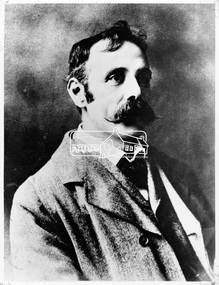
Photograph, Walter Herbert Withers (1854-1914), c.1920
Walter Withers (1854-1914) was born in Handsworth, Warwickshire, England. He migrated to Australia in 1882 and in time was to become one of the country's most famous painters. In 1887/8 he spent a year in London and Paris during which time he married Fanny Flinn. When he returned to Melbourne he was engaged by publishers doing black and white illustrations. In the late 1880's he became associated with artists who formed the renowned "Heidelberg School" and in 1890 moved to "Charterisville" at Eaglemont. He lived in the Heidelberg area until 1903 when he purchased a house on two and a half acres (one hectare) at the corner of Brougham and Bolton Streets, Eltham. He had long been attracted to the Eltham area, but needed access to Melbourne for his painting classes. The extension of the railway in 1901 made the move possible. He remained in Eltham until his death and is buried at nearby St Helena. Many of his important paintings were painted during these later years. There are important collections at the National Gallery of Victoria and the Geelong Art Gallery. His Eltham house remains and his name is honoured by a small park at the corner of Bible and Arthur Streets. Source: Information panel produced for EDHS exhibition in 1990. john withers collection, artist, sepp, shire of eltham pioneers photo collection, walter herbert withers, walter withers -
 Eltham District Historical Society Inc
Negative - Photograph, Walter Withers, c.1903-1914
Walter Withers (1854-1914) was born in Handsworth, Warwickshire, England. He migrated to Australia in 1882 and in time was to become one of the country's most famous painters. In 1887/8 he spent a year in London and Paris during which time he married Fanny Flinn. When he returned to Melbourne he was engaged by publishers doing black and white illustrations. In the late 1880's he became associated with artists who formed the renowned "Heidelberg School" and in 1890 moved to "Charterisville" at Eaglemont. He lived in the Heidelberg area until 1903 when he purchased a house on two and a half acres (one hectare) at the corner of Brougham and Bolton Streets, Eltham. He had long been attracted to the Eltham area, but needed access to Melbourne for his painting classes. The extension of the railway in 1901 made the move possible. He remained in Eltham until his death and is buried at nearby St Helena. Many of his important paintings were painted during these later years. There are important collections at the National Gallery of Victoria and the Geelong Art Gallery. His Eltham house remains and his name is honoured by a small park at the corner of Bible and Arthur Streets. Source: Information panel produced for EDHS exhibition in 1990.This photo forms part of a collection of photographs gathered by the Shire of Eltham for their centenary project book,"Pioneers and Painters: 100 years of the Shire of Eltham" by Alan Marshall (1971). The collection of over 500 images is held in partnership between Eltham District Historical Society and Yarra Plenty Regional Library (Eltham Library) and is now formally known as the 'The Shire of Eltham Pioneers Photograph Collection.' It is significant in being the first community sourced collection representing the places and people of the Shire's first one hundred years.Digital image 4 x 5 inch B&W Neg 120 format B&W negative B&W printsepp, shire of eltham pioneers photograph collection, eltham, walter withers, artist -
 Bendigo Historical Society Inc.
Map - Laminated map of Lake Eppalock at full capacity. Map 'E'
John Perry Collection. Laminated map of Lake Eppalock at full capacity. Black and white. The dam was built by the State Rivers and Water Supply Commission of Victoria. The dam wall height is 45 metres (148 ft) and the main embankment is 1,041 metres (3,415 ft) long. At 100% capacity the dam wall was designed to hold back 304,651 megalitres (6.7014×10¹⁰ imp gal; 8.0480×10¹⁰ US gal) of water. The surface area of Lake Eppalock is 3,011 hectares (7,440 acres) and the catchment area is 2,124 square kilometres (820 sq mi). The controlled spillway is capable of discharging 8,040 cubic metres per second (284,000 cu ft/s). Lake Eppalock supplies both stock and domestic water to the Campaspe irrigation district. It also serves as a water supply to Bendigo and Heathcote and, in more recent times, Ballarat. The lake is a major attraction for those engaging in watersports, with a number of tourist parks and accommodation facilities available. Permissible activities on the lake include high-speed boating, water skiing, sailing, canoeing, fishing and swimming. The lake's water levels were low for approximately eight years between 2002 and 2010 during a prolonged drought, which restricted the amount of recreational activity until rainfall in the latter half of 2010 returned the lake to 100 percent capacity. Built between 1961 and 1964, Lake Eppalock remains the only water storage on the Campaspe River system.map, eppalock, water, dam, reservoir -
 Eltham District Historical Society Inc
Photograph - Digital Photograph, Marguerite Marshall, Stuchbery Farm dairy, 14 March 2008
Stuchbery Farm was situated on the Plenty River bounded by Smugglers Gully to the north and La trobe Road, Yarrambat, to the east. Alan and Ada Stutchbery moved to the valley in 1890, first living in a tent where four children were born. Alfred built a home and outbuildings around 1896. They planted an orchard, then a market garden and developed a dairy. Published: Nillumbik Now and Then / Marguerite Marshall 2008; photographs Alan King with Marguerite Marshall.; p179 The dramatic steep-sided Plenty Gorge lies along the divide of two geological areas, and separates the Nillumbik Shire and the City of Whittlesea. On the Nillumbik side are undulating hills and sedimentary rock, and in Whittlesea, lies a basalt plain formed by volcanic action up to two million years ago. This provides the Plenty Gorge Park with diverse vegetation and habitats, making it one of Greater Melbourne’s most important refuges for threatened and significant species. The park, established in 1986, consists of around 1350 hectares, and extends 11 kilometres along the Plenty River, from Greensborough to Mernda. It provides a wildlife corridor for around 500 native plant and 280 animal species. The area’s plentiful food and water attracted the Wurundjeri Aboriginal people and then European settlers. By 1837 squatters had claimed large runs of land for their sheep and cattle. The Plenty Valley was among the first in the Port Phillip District to be settled - mainly in the less heavily timbered west - and was proclaimed a settled district in 1841. But by the late 1880s, the settlers’ extensive land clearing for animal grazing, then agriculture, depleted the Wurundjeri’s traditional food sources, which helped to drive them away. Many Wurundjeri artefacts remain (now government protected), and so far 57 sites have been identified in the park, including scarred trees, burial areas and stone artefacts. Pioneer life could be very hard because of isolation, flooding, bushfires and bushrangers. Following the Black Thursday bushfires of 1851, basalt was quarried to build more fire-resistant homes. Gold discoveries in the early 1850s swelled the population, particularly around Smugglers Gully; but food production made more of an impact. In the late 1850s wheat production supplanted grazing. In the 1860s the government made small holdings available to poorer settlers. These had the greatest effect on the district, particularly in Doreen and Yarrambat, where orchards were established from the 1880s to 1914. Links with a prominent early family are the remains of Stuchbery Farm, by the river’s edge bounded by Smugglers Gully to the north and La Trobe Road, Yarrambat, to the east. The Stuchberys moved to the valley in 1890, and the family still lives in the area. In 1890, Alfred and Ada first lived in a tent where four children were born, then Alfred built the house and outbuildings around 1896. They planted an orchard, then a market garden, and developed a dairy. The family belonged to the local Methodist and tennis communities. Their grandson Walter, opened the Flying Scotsman Model Railway Museum in Yarrambat, which his widow, Vi, continues to run. Wal was also the Yarrambat CFA Captain for 22 years until 1987. Walter sold 24 hectares in 1976 for development - now Vista Court - and in 1990, the remaining 22.6 hectares for the park. Remaining are an early stone dairy and remnants of a stone barn, a pig sty and a well. Until it was destroyed by fire in 2003, a slab hut stood on the Happy Hollow Farm site, at the southern end of the park. The hut is thought to have been built in the Depression around 1893. This was a rare and late example of a slab hut with a domestic orchard close to Melbourne. Emmet Watmough and his family first occupied the hut, followed by a succession of families, until the Bell family bought it around 1948. There they led a subsistence lifestyle for 50 years, despite encroaching Melbourne suburbia. The Yellow Gum Recreation Area includes the Blue Lake, coloured turquoise at certain times of the year. Following the 1957 bushfires, this area was quarried by Reid Quarries Pty Ltd for Melbourne’s first skyscrapers, then by Boral Australia. However in the early 1970s water began seeping into the quarry forming the Blue Lake and the quarry was closed. The State Government bought the site in 1997 and opened it as a park in 1999.This collection of almost 130 photos about places and people within the Shire of Nillumbik, an urban and rural municipality in Melbourne's north, contributes to an understanding of the history of the Shire. Published in 2008 immediately prior to the Black Saturday bushfires of February 7, 2009, it documents sites that were impacted, and in some cases destroyed by the fires. It includes photographs taken especially for the publication, creating a unique time capsule representing the Shire in the early 21st century. It remains the most recent comprehenesive publication devoted to the Shire's history connecting local residents to the past. nillumbik now and then (marshall-king) collection, ada stuchbery, alan stuchbery, dairy, stuchbery farm, farm buildings, yarrambat, plenty gorge park -
 Ballarat Heritage Services
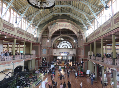
Photograph - Photograph -Colour, Clare Gervasoni, Interior of the Melbourne Exhibition Building, 2019, 31/03/2019
A competition was announced to design a suitable building for the proposed Melbourne International Exhibition in December 1877. Eighteen entries were received. The winner of 300 pounds was Joseph Reed of the architectual firm Reed and Barnes. The foundation stone was laid by Governor Sir George Bowen on 19 February 1879. Prominent Melbounre builder David Mitchell, father of Dame Nellie Melba, won the tender to construct the main building. Exhibitors were able to move in by May 1880. On 01 October 1880 the Melbourne International Exhibition opened, when over 6000 people entered the main hall to see the Governor, the Marquess of Normanby open the show. Thirty three nations participated and ofver 32,000 exhibits were displayed. At the close of the exhibition on 30 April 1881 over 1.3 million people had visited the exhibition. In 1881 Victoria's population was just over 250,000. The management of the Exhibition Building and eight hectares of the Carlton Gardens was handed to the Exhibition Trustees by the Melbourne International Exhibition Commissioners on 01 OCtober 1881. The Trustees maintained the building for 'future public exhibitions and ... general public instruction and recreation' until 1996 when management of the building was transferred to Museum Victoria. In 1901 when the Australian colonies federated there was no capital and no federal parliament building. The Federal Parliament moved into the Victorian State Parliament building, and the State Parliament moved into the Western Annexe of the Exhibition Building for 26 years. After World War One, on 04 February 1919, the exhibition Building was turned into a hospital to treat Melbournians struck down with the Spanis 'Flu'. Initially housing 500 beds, the hospital grew to accomodate 2000 patients. Femals were located between the concert platform in the western nave and the done; male patients occupied the spaces beyond. The basement was used a a morgue. With the departure of the State Parliament in 1927 the western annexe became home to the Country Roads Board. In 1932 it was joined by the MOtor Registration Branch, and the Transport Regulation Board in 1934. They co-existedin cramped offices until the 1960s. In 1949 the oval at the rear of the ExhibitionBuilding was leased to the Commonealth Government for the establishment of the Migrant Reception Centre. When it closed in 1961-62, the centre comrised 29 bungalows over 1.4 hectare. The centre provided temporary accomodation for thousands of new arrivals from Britain. On 01 July 2004 the Royal Exhibition Building and Carlton Gardens were inscribed on the World Heritage List. It is the only 19th century Great Hall to survive largely intact, still in its original landscape setting, and still used as a palace of industry. The Melbourne International Flower and Garden Show is a flower show held annually since 1995 in early April each year, in Melbourne, Australia. It is located in the World Heritage Site of Carlton Gardens and the Royal Exhibition Building.[1] It is the largest horticultural event in the southern hemisphere, attracting over 100,000 visitors. It is rated among the top five flower and garden shows in the world. (Wikipedia)Colour photograph of the interior of the Melbourne Exhibition Buildings during the 2019 Melbourne Flower and Garden Show.melbourne international flower and garden show, carlton gardens, melbourne exhibition building, royal exhibition buildings