Showing 93 items matching "heidelberg city council"
-
 Greensborough Historical Society
Newspaper Clipping, Heidelberg Leader, Bold merger call rejected, 06/08/2019
The proposal for a merger between Banyule and Nillumbik Councils made by a Nillumbik Councillor, was voted against by Nillumbik Council, as well as not being supported by Banule CouncillorsBlack & white text.banyule city council, nillumbik council -
 Greensborough Historical Society
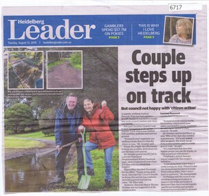
Newspaper Clipping, Couple steps up on track, by Courtney Beaumont, 13/08/2019
Rob and Christine Granter repaired a popular walking track at Banyule Flats which was in poor condition, and was criticised by the Mayor of Banyule for taking independent action.Black and white text and colour imagesbanyule flats, rob granter, christine granter, banyule city council -
 Greensborough Historical Society
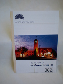
Booklet, Banyule City Council, The History of The Centre Ivanhoe, 2005_
Gives the history of The Centre Ivanhoe from its beginnings as Heidelberg Town Hall and municipal offices in the 1930s. Text and photos by Robin Grow.The Centre is an example of Art Deco architecture and has retained these features. The Banyule Council is committed to maintaining this building in its present form.12 pages, illus. (some col.).heidelberg town hall, the centre ivanhoe, art deco architecture, robin grow -
 Greensborough Historical Society
Newspaper Clipping, Booklet unlocks top tips - He0914, 23/09/2015
... College Heidelberg. banyule city council banyule youth summit our ...A book called "Life Hacks", which contains tricks and advice for school leavers, is available from Banyule Council. The booklet was launched at Our Lady of Mercy College Heidelberg.News clipping, black text, colour image.banyule city council, banyule youth summit, our lady of mercy college -
 Greensborough Historical Society
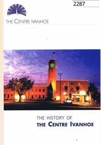
Booklet, Banyule City Council, The History of The Centre Ivanhoe, 1934_
Gives the history of The Centre Ivanhoe from its beginnings as Heidelberg Town Hall and municipal offices in the 1930s. Text and photos by Robin Grow.The Centre is an example of Art Deco architecture and has retained these features. The Banyule Council is committed to maintaining this building in its present form.12 pages, illus. (some col.). -
 Greensborough Historical Society
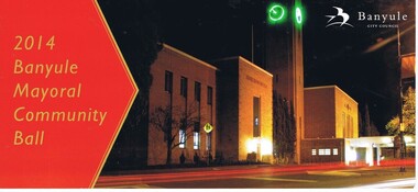
Invitation, Banyule City Council, 2014 Banyule Mayoral Ball, 03/10/2014
Invitation to Rosie Bray to the 2014 Banyule Mayoral Community Ball, The Centre Ivanhoe, 275 Upper Heidelberg Road Ivanhoe, 3 October 2014Card, printed both sides in colour, with postage envelopebanyule city council, rosie bray -
 Greensborough Historical Society
Planning document, City of Heidelberg, Subdivision Plan # G26. Grace Park Estate Greensborough, 1950c
Plan of Subdivision (G26). Grace Park Estate. An example of hard copy subdivision plans from the Greensborough area. From Shire of Heidelberg.Plan mounted on heavy card.Stamped and handwritten Council permissions, dates and other details.subdivision plans, grace park -
 Greensborough Historical Society
Map, Saxam Heritage Overlay, 2011_
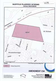
"Saxam" was the home of the Kaye family (1886-1888) then William Santon, a former councillor and Mayor of Heidelberg. Saxam Homestead is a distinctive and substantial timber homestead built in the late 1880s as one of the notable rural properties in the St Helena area. In 2014 the house still stands but is in poor condition with most interior features removed. The site had a heritage overlay as shown. The overlay was reduced in 2014 to protect the house while allowing residential development on the site.Saxam is one of the only remaining farmhouses in the Greensborough area.Copy of map and planning scheme.saxam -
 Greensborough Historical Society
Newspaper clipping, Old homestead 'not fit', 2000c
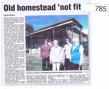
... Santon, a former councillor and Mayor of the Heidelberg City ...The article is about the demise of the homestead formerly known as "Saxam"."Saxam" was the home of William Santon, a former councillor and Mayor of the Heidelberg City Council. He was also a foundation member of Greensborough Football club in 1922.A short article featuring a colour photograph. william santon, greensborough football club, greensborough hotel, churinga, st john of god, city of heidelberg, saxam -
 Greensborough Historical Society
Folder of Documents, Greensborough Park: Land Title Histories and Associated Instruments, 1872-1976
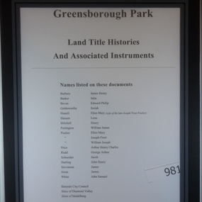
... banyule city council shire of heidelberg shire of diamond valley ...Land title documents trace the ownership of what is now known as Greensborough Park from 1872 to 1976.This property was owned at various times by well known Greensborough identities. The documents show the change from private ownership to public ownership of the site.Folder of copies of land title documents. 20 pages. Includes CD of electronic copies.greensborough park, banyule city council, shire of heidelberg, shire of diamond valley -
 Greensborough Historical Society
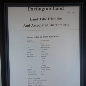
Folder of Documents, Partington land: Land Title Histories and Associated Instruments, 1826o
... council shire of heidelberg shire of diamond valley Folder ...Land title documents trace the ownership of land owned by the Partington family of Greensborough.The Partington family are Greensborough pioneers and have lived in the area since the 1840s.Folder of copies of land title documents. 36 pages. partington, plenty river, banyule city council, shire of heidelberg, shire of diamond valley -
 Greensborough Historical Society
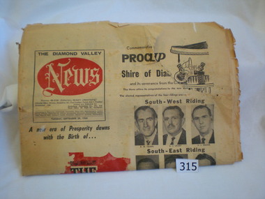
Newspaper, Diamond Valley News, Diamond Valley News. 29 Sept. 1964 : Commemorative edition : Proclamation of the Shire of Diamond Valley, 29/09/1964
The Shire of Diamond Valley was formerly the north ward of the City of Heidelberg. In 1960 following inequitable rate increases, it was proposed that the 'north ward' sever itself from Heidelberg and form its own municipality. The Shire was abolished in 1994 and areas redistributed to Banyule, Nillumbik and Darebin councils.This newspaper reports on the history and politics of the new Shire of Diamond Valley. It includes news articles and advertising material from local businesses. 40 page commemorative edition. Yellowed newsprint. Front cover icludes "The Shire of Diamond Valley" on red outline map of shire and photos of the 12 inaugural councillors. 3 copies.shire of diamond valley, greensborough, diamond valley news -
 Greensborough Historical Society
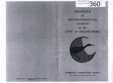
Booklet, Register of environmental assets of the City of Heidelberg 1977, 1978_
... Council website. heidelberg environmental assets city ...This is the first list of environmental assets within the City of Heidelberg (1977) and lists major parklands, small neighbourhood parks, trees of note and landscapes.An early list of environmental assets in Heidelberg, has been superseded by Strategies and Policies on the Banyule Council website.Photocopy of 28 page booklet. Copied 2 pages to an A4 sheet. heidelberg, environmental assets, city of heidelberg, parks -
 Eltham District Historical Society Inc
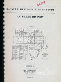
Book, Banyule City Council, Banyule Heritage Places Study - An Urban History, Volume 1 prepared by Allom Lovell & Associates, 1998 March
Describes the broad patterns of development across Banyule in the post-European contact period, 92 p, 30 cmbanyule history, greensborough history, montmorency history, heidelberg history, ivanhoe history -
 Whitehorse Historical Society Inc.
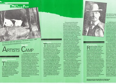
Document, Box Hill Artists Camp, 1987
Brochure written by Box Hill Historical Society and published by Box Hill City Council in 1987Brochure written by Box Hill Historical Society and published by Box Hill City Council in 1987 on the 'Artists Park', Gardiners Creek, Box Hill.Brochure written by Box Hill Historical Society and published by Box Hill City Council in 1987box hill artist's camp, heidelberg school, city of box hill, box hill historical society, gardiners creek, roberts tom, mccubbin frederick, abrahams louis, streeton arthur, condor charles -
 Kew Historical Society Inc
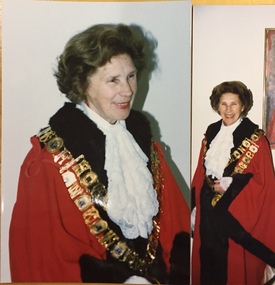
Photograph - Photographs, Cr Phyllis Hore, Mayor of Kew 1985-1986, 1985-1986
Phyllis Catherine Hore (née Kiss) was born in 1918. A Kew resident from 1949, she was elected to Council in 1972, after several attempts, and served for twenty- three years until her death in 1994. A secondary teacher by profession, Cr Hore represented College and Sackville Wards. While a councillor, she was a resident of High and later Pakington Streets. She served on Council committees and was a delegate to the Kew Elder Citizens Association, the Family and Community Services (FACS) Local Consultative Committee, and the Kew Music Centre Board of Management. During her Mayoral year, she was instrumental in memorialising Vance and Nettie Palmer, significant Kew writers and poets, by unveiling a plaque at the Kew Library in the year of the centenary of their births. In May 1994, the Mayor of Kew, Cr Tom Indovino, named a meeting room at Kew Library, the Phyllis Hore Room in recognition of her service to the City. She is buried in the Heidelberg (Warringal) Cemetery. (Source: Chairmen and Mayors of Kew 1960-1994, p. 88)Two colour 'proofs' of mayoral photos of Cr Phyllis Hore, donated by her daughter in 2019cr phyllis hore, mayors of kew (vic) -
 Greensborough Historical Society
Poster - Planning Document, City of Heidelberg, Subdivision Plan # G313, Corner Main and Grimshaw Streets, Greensborough, 08/03/1960
Plan of Subdivision at corner of Main and Grimshaw Streets, Greensborough.An example of hard copy subdivision plans from the Greensborough area. Mainly from the Shire of Diamond Valley era (1964-1994).Plan (2 sheets) mounted on heavy card.Stamped and handwritten Council permissions, dates and other details.subdivision plans, main street greensborough, grimshaw street greensborough -
 Eltham District Historical Society Inc
Photograph - Digital Photograph, Alan King, Nillumbik Shire Offices, Greensborough, 30 March 2008
Nillumbik Shire Council transferred to the former Diamond Valley Shire Offices in Greensborough after municipal restructuing. The offices became the official Nillumbik Shire Council Offices on 16 October 1995. The former Shire of Diamond Valley Civic Centre or Shire Office building was officially opened on 26th February 1972. Archtiects were A.K. Lines, McFarlane & Marshall and it was built by L.U. Simon Pty Ltd, The Diamond Valley Shire had been created in 1964 from part of the City of Heidelberg. On December 15, 1994 the Shire of Nillumbik was established. Under the Council amalgamations imposed by the Kennett government, the Shire of Eltham, Shire of Diamond Valley and City of Heidelberg ceased to exist with the establishment of Nillumbik Shire Council and the City of Banyule.The new Nillumbik shire surrended the west riding from Eltham to Banyule but in place gained parts of the former Diamond Valley Shire which itself had been created in 1964 from parts of the City of Heidelberg. Three unelected and non-local Commissioners were put in place by the government bringing democracy into question by many members of the local community. The Commissioners determined to abandon the former Shire of Eltham offices located in Main Road, Eltham and in turn occupy the former Shire of Diamond Valley offices located at the boundary of the new shire with Banyule, in Civic Drive, Greensborough. In July 1996 the Commissioners sold the former Eltham Shire Offices and had them bulldozed leading to many years of communiity protest over the process and future development applications. The site has remained vacant ever since. Published: Nillumbik Now and Then / Marguerite Marshall 2008; photographs Alan King with Marguerite Marshall.; p43 It was the need for roads that led to this district’s first council. In 1853 a committee was formed to improve the rough roads, some in Kangaroo Ground being almost impassable in winter.1 The committee fundraised by voluntary levies and grants to improve in particular, the main road between Kangaroo Ground and the Plenty River. From this committee arose the Eltham District Road Board, in 1856, which was the precursor to the Eltham Shire Council. The Board’s first chairman was Kangaroo Ground farmer, John Barr. Secretary was the former committee’s secretary, Andrew Ross, Kangaroo Ground’s first school teacher, and founder of the district newspaper, The Evelyn Observer.2 Most of the board’s income came from a toll-house north of the Lower Plenty Bridge, which funded such projects as a road from Kangaroo Ground to the Caledonia Diggings. In 1871 the Shire of Eltham was proclaimed, with its boundaries the same as those of the Road Board, and Councillor A Donaldson of Kangaroo Ground was the first president. Eltham was at the southern tip of the shire, which extended north to Kinglake and east beyond Yarra Glen. In 1878, part of Kinglake was added to the shire, while the area east of Watts River, near Healesville was removed. In 1912, then again in 1958, the shire was further reduced. Yarra Glen, Steels Creek, Tarrawarra, parts of Healesville and Christmas Hills, were transferred to the Shire of Healesville. In 1972 a smaller area, at Kinglake, was transferred to the Shire of Yea, leaving 277 square kilometres in the Eltham Shire. Perhaps no other Victorian municipality has had so many meeting places. Although from 1858 to 1904, the council convened at the office in the home of Secretary Charles Wingrove, the board, and later the council, also met at other more central locations.3 The board moved from the Fountain of Friendship Hotel to the Eltham Courthouse, to the Kangaroo Ground schoolhouse. It then met at the Kangaroo Ground Hotel, which some considered put it in danger of interruptions by people ‘the worse for liquor’.4 In 1885 the council met at the hall on Mr J Donaldson’s land at Kangaroo Ground. After Wingrove’s retirement, the council rented space at the Kangaroo Ground General Store and Post Office. Then, in 1917, the council bought the former office of The Evelyn Observer, after its printing works transferred to Hurstbridge. In 1934, fire destroyed the shire office, which was temporarily relocated to the Kangaroo Ground home of Shire Secretary, Mr P J McMahon. In 1941, the shire office moved to a new building (which included a public hall) in Eltham, at the corner of Arthur Street and Main Road, where the Eltham Village Shopping Centre was eventually built. Growth required new offices, which opened in 1965, on the former Shillinglaw property in Main Road.5 In 1994, as part of municipal restructuring under the Jeff Kennett Liberal Government, most of the Eltham Shire formed part of the new Shire of Nillumbik. It joined with the north section of the Diamond Valley Shire and parts of the Healesville and Whittlesea municipalities. The Diamond Valley Shire had been created in 1964, from part of the City of Heidelberg. Turbulence followed Nillumbik Shire’s formation. Under the Commissioners the council transferred to the former Diamond Valley Shire offices in Greensborough, and the Eltham council offices were demolished. In March 1997 the first five-member Nillumbik Council was elected. But, in October 1998, the government suspended the council and appointed an administrator . Early in 1999, shire residents voted to increase councillors to nine: comprising five ward councillors and four shire-wide councillors. Elections were held in March 1999. Then, before the March 2002 elections, nine new wards were created.6 In 2008 these were reduced to seven. Today [2008] the council governs a varied population of more than 60,000 people living in townships and on bush properties in the green wedge.This collection of almost 130 photos about places and people within the Shire of Nillumbik, an urban and rural municipality in Melbourne's north, contributes to an understanding of the history of the Shire. Published in 2008 immediately prior to the Black Saturday bushfires of February 7, 2009, it documents sites that were impacted, and in some cases destroyed by the fires. It includes photographs taken especially for the publication, creating a unique time capsule representing the Shire in the early 21st century. It remains the most recent comprehenesive publication devoted to the Shire's history connecting local residents to the past. nillumbik now and then (marshall-king) collection, greensborough, nillumbik shire council offices, civic drive -
 Eltham District Historical Society Inc
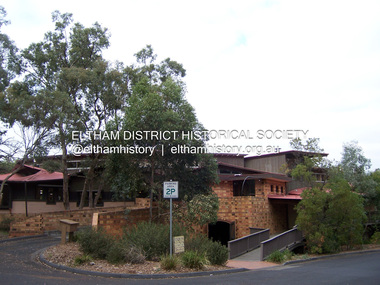
Photograph - Digital Photograph, Marguerite Marshall, Eltham Library, Panther Place, Eltham, 18 April 2008
Rear view of Eltham Library showing loading dock and ramp to the front of the building. Designed by multi-award winning architect, Gregory Burgess, for which he won the 1995 Royal Australian Insitute of architects (Vic.) Merit Award in the New Institutional category. Covered under Heritage Overlay, Nillumbik Planning Scheme. Published: Nillumbik Now and Then / Marguerite Marshall 2008; photographs Alan King with Marguerite Marshall.; p183 Award-winning Eltham Library, with its earthy tones blending into the nearby parklands, celebrates some of the best of Eltham’s spirit. Designed by multi-award winning architect, Gregory Burgess, the library at Panther Place, won him the 1995 Royal Australian Institute of Architects (Vic) Merit Award in the New Institutional category.1 The design is typical of Burgess’ work, emphasising natural materials and forms, and the integration of building and site.2 In its distinctive architectural character, Burgess celebrated the spirit of Eltham’s artist/architect Justus Jörgenson and mud-brick builder Alistair Knox. However this library, which opened in 1994, follows decades of efforts to acquire a suitable library for local residents. It was only in 1971 that Eltham acquired its first purpose-built library. In the 1930s books were borrowed from a mobile library run by Mr Foster of Bible Street. From the 1930s to the early 1950s, adults borrowed books from the newsagency and general store in Main Road (still a newsagency) near Arthur Street. As late as the 1950s, adults borrowed books in the shire office foyer, then in Main Road near the corner of Arthur Street.3 In the early 1950s the ratepayers voted for lower rates rather than a library, in a referendum to build a public library financed by higher rates. Children depended on volunteers for their library service until 1966. In 1946 the inaugural meeting of the Eltham War Memorial Trust’s Women’s Auxiliary, decided to support the Trust by raising funds to buy land and build a Children’s Library, Baby Health Centre and other facilities. The auxiliary formed the Children’s Library Committee, which included Mrs Morrison, Mrs Bow and Mrs Currie. They ran a library service in the stage area of the Eltham Hall, at the corner of Arthur Street and Main Road. In 1952 the books were relocated to a room in the newly opened Baby Health Centre on Main Road. Then in 1961, the Children’s Library received its own hall beside the Eltham Pre-School Centre on Main Road. From there, each month, volunteers delivered books to every school in the shire. In 1966 the Children’s Library closed after 17 years of service, following the transfer of the Trust land and buildings to the Shire of Eltham. The books were donated to nine schools in the shire and to Community Aid Abroad. An important boost to the library service came in 1965, when the Heidelberg Regional Library Service was formed by the City of Heidelberg with the Shires of Eltham and Diamond Valley. Its first library service for Eltham Shire was a bookmobile van. Books for children and adults were finally housed in one building in 1966, when the shire converted the Brinkkotter house in Dudley Street, into a library. At last in 1971, the Eltham Library moved to new premises attached to the shire offices near Panther Place. However these were demolished in 1996, by State Government appointed commissioners during council amalgamations. Meanwhile the Heidelberg Regional Library Service was disbanded in 1985 and the Yarra Plenty Regional Library Service was established. The burgeoning population brought pressure for a bigger library. Eltham was one of several municipalities in the 1970s and 1980s, battling with the State Government for adequate funding for public libraries. Funds were so tight, that in 1987 Eltham councillors threatened to close the library. However public petitions persuaded them to set aside funds to replace the cramped library facilities. In 1992 the Federal Government gave $887,496 towards the $3 million cost of the 1560 square metre library.4 The result is a light and spacious building with surrounding verandas, made of sustainable natural materials including earth and recycled and radially sawn timbers. It includes a gallery and function areas. In 2004 Mr Burgess won Australian architecture’s highest accolade: the Royal Australian Institute of Architects Gold Medal. He has received more than forty professional and community awards.This collection of almost 130 photos about places and people within the Shire of Nillumbik, an urban and rural municipality in Melbourne's north, contributes to an understanding of the history of the Shire. Published in 2008 immediately prior to the Black Saturday bushfires of February 7, 2009, it documents sites that were impacted, and in some cases destroyed by the fires. It includes photographs taken especially for the publication, creating a unique time capsule representing the Shire in the early 21st century. It remains the most recent comprehenesive publication devoted to the Shire's history connecting local residents to the past. nillumbik now and then (marshall-king) collection, eltham, eltham library, panther place -
 Greensborough Historical Society
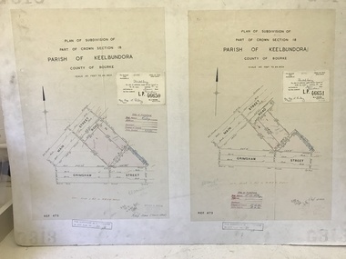
Poster - Planning Document, City of Heidelberg, Subdivision Plan # G 27, Greensborough and Diamond Creek, 1922 and 1963
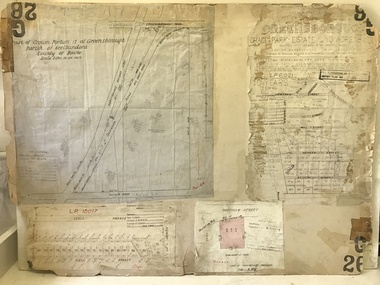
Plan of Subdivisions in City of Heidelberg: Side 1: 2 plans, Parish of Keelbundoora: plan 1: Henry Street, Vermont Avenue, Lyell Street, Nell Street, McDowell Street, 1922. Plan 2: Henry Street, Nepean Street, Charles Street, 1922. Side 2: 2 plans Parish of Nillumbik, Portion 13: Plan 1: Diamond Creek Road, Delfin Crescent, Ridge Road, 1963. Plan 2: Kinglake Road, Eltham Road, 1963.An example of hard copy subdivision plans from the Greensborough area. Mainly from the Shire of Diamond Valley era (1964-1994).Plan (2 sided) mounted on heavy card. Contains 2 sheets pasted together.Stamped and handwritten Council permissions, dates and other details.subdivision plans, city of heidelberg -
 Greensborough Historical Society
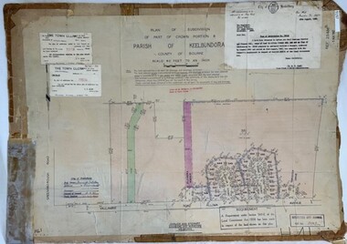
Poster - Planning Document, City of Heidelberg et al, Subdivision Plan # H 41 - Crown portion 8, Parish of Keelbundoora - Yallambie, and Crown Portion 9, Parish of Keelbundoora, 1922-1967
Planning Document: Subdivision Plan # H 41 Side 1, Crown portion 8, Parish of Keelbundoora - Yallambie Road, Allima Avenue, Koolya Court, Ekam Court (Jennings Estate). Side 2: Crown Portion 9, Parish of Keelbundoora consist of 5 small subdivision sheets: 1. Somers Avenue, Stewart Terrace, Toubay Street and Railway Place (no date); 2. Somers Avenue, Maxwell Street, Greensborough Road, 1924; 3. Heidelberg Avenue, Golf Avenue, St Andrews Avenue (no date); 4. Birdwood Avenue, May Street (no date); 5. Strathallan Road 1924.An example of hard copy subdivision plans from the Greensborough area. Mainly from the Shire of Diamond Valley era (1964-1994).Plan (2 sided) mounted on heavy card. Stamped and handwritten Council permissions, dates and other details.subdivision plans, city of heidelberg, yallambie, macleod, greensborough -
 Greensborough Historical Society
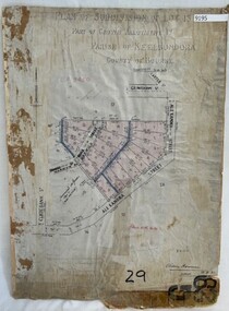
Poster - Planning Document, City of Heidelberg, Subdivision Plan # G 29 Part 1, Crown allotment 17, Greensborough, 1922
Plan of Subdivisions in City of Heidelberg: Parish of Keelbundoora: Crown allotment 17 - Warwick Road, Clydbank Street, Alexandra Street, 1922.An example of hard copy subdivision plans from the Greensborough area. Mainly from the Shire of Diamond Valley era (1964-1994).Plan (single sided) mounted on heavy card. Stamped and handwritten Council permissions, dates and other details.subdivision plans, city of heidelberg -
 Greensborough Historical Society
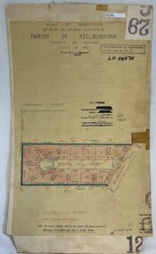
Poster - Planning Document, City of Heidelberg, Subdivision Plan # G 29 Part 2, Crown portion 16, Greensborough, 1951
Plan of Subdivisions in City of Heidelberg: Parish of Keelbundoora: Crown portion 16 - Daours Court and Devonshire Road, 1951.An example of hard copy subdivision plans from the Greensborough area. Mainly from the Shire of Diamond Valley era (1964-1994).Plan (single sided) mounted on heavy card. Stamped and handwritten Council permissions, dates and other details.subdivision plans, city of heidelberg -
 Greensborough Historical Society
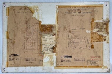
Poster - Planning Document, City of Heidelberg et al, Subdivision Plan # 5 - Crown Portion 17, Parish of Nillumbik, and Crown Portion18, Parish of Keelbundoora, 1925-1972
Subdivision Plan # 5 - Side 1: Crown portion [unknown - damaged], Parish of Nillumbik, Springfield Street, Turner Street Briar Hill,1963 amended 1972 and Crown Portion17, Parish of Keelbundoora: Thoona Grove, Donald Street. Paterson Crescent Greensborough, 1963 amended 1967. Side 2: Parish of Keelbundoora, Crown Portion 18: Boyd Street, Kempston Street Greensborough 1925; and Main Street Greensborough. An example of hard copy subdivision plans from the Greensborough area. Mainly from the Shire of Diamond Valley era (1964-1994).Plan (2 sided) mounted on heavy card. Stamped and handwritten Council permissions, dates and other details.subdivision plans, city of heidelberg, greensborough, briar hill, main street greensborough -
 Greensborough Historical Society
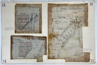
Poster - Planning Document, City of Heidelberg, Subdivision Plan # 35 - Parish of Keelbundoora, Crown Portion 16, Watsonia, 1918
Subdivision Plan # 35 Parish of Keelbundoora, Crown Portion 16: 3 plans on one sheet. Plan 1: Lambourn Road, Boger Street, Kenmare Street, Greensborough Road, Devonshire Road, Watsonia (stamped "Superseded"). Plan 2: an update of plan 1. Plan 3: Also Lambourn Road, Boger Street, Kenmare Street, dated 1918, Shire of Heidelberg.An example of hard copy subdivision plans from the Greensborough area. Mainly from the Shire of Diamond Valley era (1964-1994).3 Plans (single sided) mounted on heavy card. Stamped and handwritten Council permissions, dates and other details. Plan 1 has been stamped in red "SUPERCEDED" and overwritten by hand "Cancelled".subdivision plans, city of heidelberg, greensborough, main street greensborough, shire of heidelberg, watsonia -
 Greensborough Historical Society
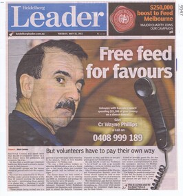
Article - Newspaper Clipping, Heidelberg Leader, Free feed for favours, 31/05/2011
Banyule Councillor Wayne Phillips arranging a dinner for politicians and corporate big wigs whilst volunteers paid for themselves to attend a similar event.Text and large colour photowayne phillips, banyule city council -
 Melbourne Tram Museum
Newspaper, The Argus, Trove, "New Tramways - Heidelberg - Essendon Line Wanted", 1/04/1924 12:00:00 AM
Copy of a newspaper article accessed from Trove 22/2/2019 from The Argus newspaper 1/3/1924 - titled "New Tramways - Heidelberg - Essendon Line Wanted" Reports on a meeting of northern city councils with the MMTB to discuss the proposed tramway notes the General Scheme and other proposed tramways. Notes Mr. Cameron's comments regarding losses, 10 miles of tramway, alternative routes, buses, road construction costs. Sourced following a query regarding fare tokes (see Reg Item 3359) and noted on the same page of the newspaper.trams, tramways, general scheme, new tramway, essendon, heidelberg -
 Heidelberg Golf Club
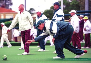
Photograph, Banyule City Council, Heidelberg Golf Club Bowling Club members at Greensborough Bowling Club 2014, 2014
Heidelberg Golf Club Bowling Club members are shown at Greensborough Bowling Club in 2014. Members are identified as Ian Bibby, Paul Sarris and Stewart Baker. The photograph was included in the Banyule calendar for 2014.Colour photograph of bowlers on the greenheidelberg golf club bowling club, greensborough bowling club, banyule community calendar, lawn bowls -
 Heidelberg Golf Club
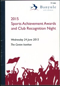
Booklet, Banyule City Council, 2015 Sports achievement awards and club recognition night, 24/06/2015
Banyule City Council Sports achievement awards and club recognition night for 2015 lists winners in all categories. On page 30, Heidelberg Golf Club Bowling Club is among the Community Clubs of the Year.32 p., colour illus.heidelberg golf club bowling club, banyule city council, sports awards -
 Greensborough Historical Society
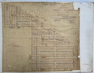
Poster - Planning Document, City of Heidelberg, Subdivision Plan # 19 - Parish of Keelbundoora, Crown Portion 16, Watsonia "Black's subdivision', 1924
Subdivision Plan # 19 - Parish of Keelbundoora, Crown Portion 16, Watsonia "Black's subdivision". This subdivision plan includes proposed street names which were later changed (e.g. Morwell Street (not Morwell Avenue) now called Greenwood Drive). Includes Lambourn Road, Black Street, Grace Street, Eden Avenue, High Street, Kenmare Street, Morwell Avenue, Greensborough Road, Mundy Street, Ladd Street.An example of hard copy subdivision plans from the Greensborough area. Mainly from the Shire of Diamond Valley era (1964-1994).Plan (single sided) mounted on heavy card. Stamped and handwritten Council permissions, dates and other details. subdivision plans, city of heidelberg, greensborough, main street greensborough, shire of heidelberg, watsonia, black family