Showing 2918 items matching "highways"
-
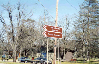 Ballarat Tramway Museum
Photograph - Colour Photograph/s - set of 2, Warren Doubleday, 13/09/2003 12:00:00 AM
Set of two colour photographs of the then new road signs indicating the BTM using the words "Tourist Tramway" in the central median strip of Sturt St. West, or Western Highway at the intersection with Hamilton Ave. Photos taken by Warren Doubleday on 13.09.2002. Printed on Agfa Paper. 2604.1 - Taken from the western side 2604.2 - ditto, but further back. On rear of each photo in brown felt tip pen, the words "New Signage at Highway".btm, hamilton ave, western highway, sturt st west -
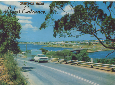 Lakes Entrance Historical Society
Postcard - Views of Lakes Entrance c1972, 1972 c
Princes Highway looking down to North Arm bridge with town in distance, people camped on North Arm foreshore and car towing caravan in foreground Lakes Entrance VictoriaColour postcard taken from Princes Highway looking down to North Arm bridge with town in distance, people camped on North Arm foreshore and car towing caravan in foreground Lakes Entrance VictoriaGreetings from Lakes Entrancebridges, roads and streets, township, vehicles -
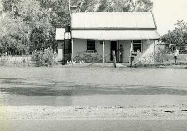 Charlton Golden Grains Museum Inc
Photograph, Charlton Tribune, 1973 February Flood, Feb 1973
Feb 1973 flood Charlton, Victoria. Old Ive's house with floodwater to front fence on the Calder Highway opposite Charlton Park Gates. Mrs Gloria Jordan.B/W Photograph of February 1973 flood. Old Ive's house with floodwater to front fence on Calder Highway opposite Charlton Park gates. Photo used in Charlton Tribune on 09/07/1973 P4.flood, charlton, calder highway, local brick -
 Kew Historical Society Inc
Photograph - Outer Circle Railway Viaduct
The heritage listed Fairfield Bridge was originally constructed for the Outer Circle Railway to bridge the Yarra River between East Kew and Fairfield stations. In the 1930s it was converted for vehicular traffic. In the 2010s a new concrete bridge was erected beside it to increase vehicular capacity.Print copy, enlarged from original snapshot, of the former railway viaduct crossing the Yarra and linking Kew and Fairfield. The original photo predates the conversion of the viaduct into the Chandler Highway Bridge in the 1930s, when the Bridge was adapted to carry vehicular traffic. The date on the reverse indicates the date of donation rather than the date on which the photograph was taken. CHANDLER HIGHWAY BRIDGE OVER RIVER / (ORIGINALLY PART OF OUTER CURCLE RAILWAY) / OCTOBER 1977railway viaduct -- kew (vic.), fairfield bridge, fairfield railway viaduct, outer circle railway, sir john monash -
 Lakes Entrance Historical Society
Photograph - WW1 Memorial avenue cypresses tree carvings by John Brady, 1999
most westerly chain saw carving made from trunk of WW1 Memorial avenue cypresses. On lawn verge, south of Princes Highway, opposite Bellevue, Lakes Entrance Victoria Carved by chainsaw artist John Brady August 1998.Colour photograph of the most westerly chain saw carving made from trunk of WW1 Memorial avenue cypresses. On lawn verge, south of Princes Highway, opposite Bellevue, Lakes Entrance Victoriaworld war 1914-1918, memorials -
 Whitehorse Historical Society Inc.
Article, School Kids Go 'Green', 22/09/1993 12:00:00 AM
Primary School children plant trees along Melbourne Water Pipetrack in Forest Hills.Primary School children plant trees along Melbourne Water Pipetrack in Forest Hills. Final part of Melbourne Water's revegetation of 5 K section of Pipetrack between Springvale Road and Burwood Highway, involving Community Groups, incl. photo.Primary School children plant trees along Melbourne Water Pipetrack in Forest Hills. melbourne water, community groups, primary schools, bowden, cliff, torres, norman, jackson, katherine -
 Lakes Entrance Historical Society
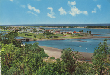
Postcard - Views of Lakes Entrance c1970, John Engelander and Co Melbourne, 1970 c
Princes Highway to town showing concrete bridge over North Arm . Also identical postcard with message on back in Spares boxColour postcard of view from Princes Highway to town showing concrete bridge over North Arm old toilet block opposite road to Bullock Island, Club Spit being formed, Hill 60 visible on outer barrier hummocks Lakes Entrance Victoriaroads and streets, township, waterways -
 Chelsea & District Historical Society Inc
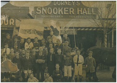
Photograph - Chelsea Junior Football Club, posed in front of Dorney's Shop, 1922
The Chelsea Junior Football Club with Bill Dorney in front of Bill Dorney Shop. Mr Dorney had taken the boys for a ride on his horse and cart. Mr Dorney's Hairdressing and Billiard Saloon was situated at 415 Nepean Highway, Chelsea. The premises was destroyed by fire in August 1937.Black and white photo of junior football players of Chelsea Junior Football Club. The group are posed in front of William (Bill) Dorney's Hairdressing shop & Billiard saloon in Nepean Highway, Chelseafootball, chelsea junior football club, chelsea, sport, william dorney, shop, nepean highway, horse and cart -
 Melton City Libraries
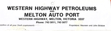
Archive, Western Highway Petroleum, Unknown
Advertisement of Western Highway Petroleum, business previously located on Western Highway, Melton. local identities -
 Stawell Historical Society Inc
Photograph, Pleasant Creek Special School, Sister Rocks, Western Highway Stawell Nov 1975, Nov 1975
Photographs taken by teacher at Pleasant Creek Training Centre to help train students in living skills and becoming familiar with what shops sold. Part of socializing students for leaving the training centre.Western Highway education, tourism -
Lakes Entrance Historical Society
Map - Map of Lake Tyers Forest and Waterways
... Highways ...Map of Lake Tyers showing forest and waterways.forest, waterways, highways -
Whitehorse Historical Society Inc.
Article, People before profit - land sale opponent, 1992
A community group has criticised Nunawading Council's move to rezone and sell the Vermont South site it uses.A community group has criticised Nunawading Council's move to rezone and sell the Vermont South site it uses. The land is on the corner of Burwood Highway and Livingstone Road which is zoned D 'Public Open Space'. Council has deferred the decision to rezone until after a public meeting.A community group has criticised Nunawading Council's move to rezone and sell the Vermont South site it uses.town planning, city of nunawading, burwood highway, vermont south, livingstone road, vermont south, vermont south -
Ringwood and District Historical Society
Newspaper - Newspaper cutting, The story of the Ringwood Memorial Clock Tower erected 1928 incl list of Roll of Honour names, 4-Aug-28
Around 1940-42 the clockwork mechanism was wound by hand for payment of 2/6 (25 cents) per week, payable half yearly. The clock tower was removed and re-erected in 2000 at the intersection of Maroondah Highway and Wantirna Road, with a new electric winding mechanism.The story of the Ringwood Memorial Clock Tower erected 1928 at a cost of approx $1700 and unveiled 4-Aug-1928 at the intersection of Maroondah Highway and Warrandyte Road. It commemorates those who served and those who lost their lives in WW1.ROLL OF HONOUR; Addison, W.J.; Allan, A.; Bailey, A.F.; Bolton, E.; Brain, W.; Brown, A.G.; Brown, W.; Brown, C.H.; Browning, D.; Brocksop, P.; Bruce, R.T.; Butler, W.J.; Cairnduff, J.B.; Castles, D.; Chivers, S.R.; Chivers, A.; Clemson, J.K.; Cutts, C.W.G.; Cutts, N.F.L.; Cooper, J.; Dehne, P.C.; Dawes, L.F.; Dawes, F.A.; Dawes, C.A.R.; Foster, A.; Franks, C.V.W.; Ford, T.; Franklin, E.; Fitts, E.; Goodall, R.; Goodall, J.H.; Grant, T.W.; Guy, W.H.; Hannah, J.; Harris, D.B.; Hardidge, B.; Hains, C.L.; Hefferson, R.H.; Hodgetts, L.F.; Hodgetts, W.C.; Homewood, L.; Howship, M.L.; Howship, F.R.; Howship, S.P.; Hubbard, H.; Johnston, W.J.; Johnston, R.A.; Johnston, C.H.; Justice, Rev. T.H.; Kennedy, G.; Kraefft, H.G.; Lang, A.C.; Larkwing, A.H.; Lawlor, J.; Lothian, J.C.; Maggs, C.B.; Martin, E.; McCann, R.; McGillvray, M.; McKinnon, J.; Miles, Sister A.F.; Miles, T.A.; Miles, R.F.; Miles, K.L.; Miles, L.E.; Milner, T.; Miller, S.; Moss, L.S.; Moss, C.B.; Muller, G.W.; Muller, J.H.; Neal, A.G.; Nield, F.N.; Parker, A.; Parker, R.; Parker, F.V.; Parker, T.S.; Paris, C.C.; Peake, A.; Pearson, H.F.; Pollard, J.L.; Ratten, C.J.; Ratten, W.G.; Read, I.; Sanders, J.; Shanks, R.J.; Smith, S.; Smith, P.C.; Smith, C.; Stephenson, R.H.; Stowell, H.A.; Taylor, J.; Thomas, H.O.; Thomas, I.; Thompson, A.R.; Thorpe, J.G.; Tomholt, S.J.; Toogood, E.G.; Venables, W.E.; Walker, J.; Wedge, C.H.; Wedge, J.W.K.; Whitchurch, A.; Wilson, L.J.; Williams, J.A.; Williams, W.G.; Wright, S.; Wright, J.W.C.; DIED ON SERVICE; Johnston, C.H.; McCann, H.J.; Mackinlay, H.W.; Mitchell, L.; Morris, J.; Pollard, H.L.; Palmer, E.R.; Parker, J.J.; Rooney, E.; Schonfelder, A.W.; Thurrowgood, W.; Todd, J.; Thomas, R. -
 Kiewa Valley Historical Society
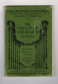
Book - Reference Cricket, The Cricket on the Hearth, circa 1930
A text book used by a local Tawonga student in the 1930's. The school she attended was Rosehill Girls School in Albury. This was one of the foundation schools of Scots School, Albury. Rosehill was opened in 1926 by a Miss Lillian Windridge, for both day and boarding students, in a large former residential property on the corner of Crisp and Young Streets and was named after her uncle's property 'Rosehill' near Kyneton in Victoria. It catered from kindergarten to the Leaving Class. The school flourished and extra space was made available at the adjacent 'Springfield' property for more classrooms. In 1934 lack of space forced 'Rosehill' to move to a new location in Kiewa Street. In 1938, Miss Windridge sold the school to Miss Anna Drennan, a well educated Scots woman with a Masters' degree from Edinburgh University. By early 1939 the school was again overcrowded and was moved to the property 'Woodstock' in Schubach Street, East Albury and the name changed to 'Woodstock School for Girls'. In 1972, the Woodstock Presbyterian Girls School and the Albury Grammar School amalgamated to form the Scots School Albury. Wilma's family were one of the early families to settle in the Kiewa Valley and had a property at Tawonga. After her marriage, Wilma moved, with her husband, to Mt. Beauty until 1958 when they moved back to manage the farm and remained there for the rest of her life.It has a social significance as it depicts the standard of literature that was expected to be read and appreciated by students in the 1930's era. As the school was situated in Albury, it meant that the student would have been a boarder as daily transport to and from the Kiewa Valley would have been impossible at that time, unlike the 'School Bus' run that is available today. At this time there was no 'secondary education' available in the valley and education beyond primary school would have been limited to children of families that could afford to send their children to board at privately run schools.Book of literature by Charles Dickens. Has green cover with black lettering and decoration. It seems to be one of a series of books called the 'Highways and Byways of English Literature". On the front cover, at the top, 'Highway and Byways of English Literature'. Centre of page is the title "The Cricket on the Hearth" and the author Dickens. Underneath this is 'Blackies English Texts Edited by W.H.D.Rouse, Litt.D." Across the foot of the page is 'Blackie and Son Limited'. On the first page, hand written in ink is "Wilma Roper, Rosehill G.S.,Albury."secondary education, albury, kiewa valley, tawonga -
Whitehorse Historical Society Inc.
Book, Grey ribbon to the border, 1973
History of the Hume HighwayHistory of the Hume HighwayHistory of the Hume Highwayhume highway, victoria -
 Melbourne Tram Museum
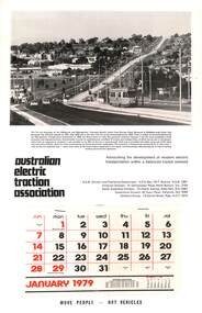
Document - Calendar, AETA 1979 featuring the new Burwood Highway tram line
The AETA published calendars on an annual basis through to 2005, promoting electric transport in Public Transport. The MMTB photo features Z25 inbound on Burwood Highway. The caption gives a description of the project.Yields information about the AETA promotional activities.Australian Electric Traction Association (AETA) Calendar for 1979, featuring a photograph of Burwood Highway with Z class tram 25. Gives contact details for the AETA divisions. Stapled to the sheet is a 12 sheet preprinted calendar for 1979 with various details of holidays etc. Printed on card with a punched hole on the top edge. calendars, aeta, z class, burwood highway, new tramway, tram 25 -
 Ringwood and District Historical Society
Photograph, Warrandyte Road Ringwood - 2.9.1992
View of East side of Warrandyte Road approaching Maroondah Highway intersection. Rear view of Maroondah Highway businesses.Written on back of photograph: "2.9.92. Warrandyte Road.Was the Caltex garage.etheridge ford, lawfords furniture, treeby real estate, wright brothers electrics -
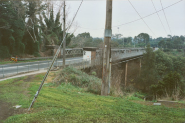
![Photograph - Construction of the F19 [Eastern Freeway], Ron Setford, December 1977](/media/collectors/550653872162f11fb04854aa/items/683bd9a969688f11138e8cf5/item-media/683bd9d369688f11138e8f9b/item-fit-380x285.jpg) Kew Historical Society Inc
Kew Historical Society IncPhotograph - Construction of the F19 [Eastern Freeway], Ron Setford, December 1977
Ron Setford and his wife Grace Setford lived in Tanner Avenue, East Kew, from c.1946 to c.1995. A keen photographer, he recorded the changing face of Kew over a 20 year period. Apart from 30 photographs of built structures and places in Kew dating from 1960 and 1961, 145 of his 35mm colour slides chronicle the development of the F19 (later renamed Eastern) Freeway through the Yarra Valley in Kew over a five year period from c.1972 to c.1977. This important collection was donated to the Society by his granddaughter in 2025.This collection of 175 35mm slides is of local and statewide significance, owing to its subject matter, particularly the major development of road transport infrastructure during the 1970s with the construction of the Eastern Freeway. The photographer also took care to annotate and date most of his slides which enable the researcher to pinpoint temporal and spatial locations."Highway Guides"ron setford, eastern freeway, f19 freeway -
 Ringwood and District Historical Society
Map, Department of Mines, Plan of area applied for under the mining leases regulations in the township of Ringwood between Maroondah Highway and Mt. Dandenong Road. Mining District of Castlemaine, County of Mornington, Parish of Ringwood T Area 58(A) 2 (R)15(P) Acres, Roods, Perches. 1934, 20-Feb-34
Map of the township of Ringwood with subdivisions between Maroondah Highway and Mt. Dandenong Road. the area applied for on lease No.8210 by E.G.Browne.Mining District of Castlemaine, County of Mornington, Parish of Ringwood T Area 58(A) 2 (R)15(P) Acres, Roods, Perches.Buff coloured sheet foolscap with black printing showing map of the township of Ringwood between Maroondah Highway and Mt. Dandenong Road. Mining District of Castlemaine, County of Mornington, Parish of Ringwood T Area 58(A) 2 (R)15(P) Acres, Roods, Perches +Additional Keywords: Browne E.G. -
 Kew Historical Society Inc
Photograph - Former Chandler Highway Bridge, 2001
The heritage listed Fairfield Bridge was originally constructed for the Outer Circle Railway to bridge the Yarra River between East Kew and Fairfield stations. In the 1930s it was converted for vehicular traffic. In the 2010s a new concrete bridge was erected beside it to increase vehicular capacity. Original colour print positive of the (former) Chandler Highway bridge in 2001. The point of view is from the Fairfield side of the river looking towards Kew. The heritage listed bridge was originally constructed for the Outer Circle Railway to bridge the Yarra River between East Kew and Fairfield stations. In the 1930s it was converted for vehicular traffic. In the 2010s a new concrete bridge was erected beside it to increase vehicular capacity. Ink inscription on reverse: "Chandler Highway bridge / (Originally Outer Circle Railway Bridge) / From Fairfield side towards Kew / July 2001"bridges -- kew (vic), fairfield bridge, chandler highway bridge, outer circle railway viaduct -
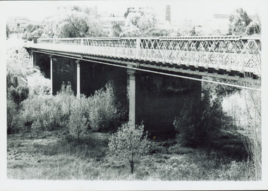
 Kew Historical Society Inc
Photograph, Outer Circle Railway Bridge over River Yarra, c.1900
This photograph forms part of the Eric Sibly collection of images and information relating to the Outer Circle Railway which he donated to the Kew Historical Society in 1974. Heritage Victoria Citation (Abridged) "The Chandler Highway Bridge, a 137 metre wrought iron lattice-truss girder bridge with four spans supported on red brick piers with moulded bluestone cappings. The bridge has a cantilevered walkway along the west side. ...The Chandler Highway Bridge crosses the Yarra River and connects Alphington and Kew. It was completed in November 1890 as part of the Outer Circle Railway Line.Black & white photograph of the railway viaduct over Yarra River looking south towards Kew.Reverse: "Pre 1930. Outer Circle Railway Bridge over River Yarra (now Chandler Highway) - note bridge over line on Kew side for Asylum Farm". KH - 56. Kew Historical Society.chandler highway, railway bridges - kew (vic), sir john monash, outer circle railway, river yarra - kew (vic) -
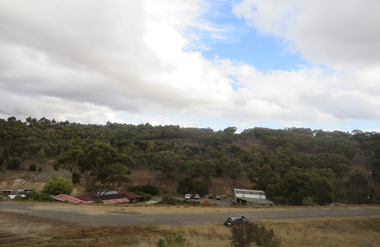
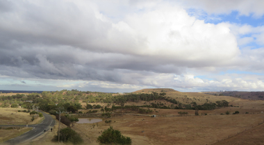
 Ballarat Heritage Services
Photographs - Colour, Clare Gervasoni, Settlement ner the Pentland Hills from the Western Highway, 2019, 31/03/2019
Colour photograph from the Western Highway. pemtland hills -
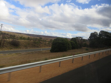
 Ballarat Heritage Services
Photographs - Colour, Clare Gervasoni, Parkside Settlement near the Pentland Hills from the Western Highway, 2019, 31/03/2019
Colour photograph from the Western Highway. pentland hills, parkside -
 Ballarat Heritage Services
Photographs - Colour, Clare Gervasoni, Parkside Settlement near the Pentland Hills from the Western Highway, 2019, 31/03/2019
Colour photograph from the Western Highway. pentland hills, parkside -
 Ballarat Heritage Services
Photographs - Colour, Clare Gervasoni, Parkside Settlement near the Pentland Hills from the Western Highway, 2019, 31/03/2019
Colour photograph from the Western Highway. pentland hills, parkside -
 Ballarat Heritage Services
Photographs - Colour, Clare Gervasoni, Parkside Settlement near the Pentland Hills from the Western Highway, 2019, 31/03/2019
Colour photograph from the Western Highway. pentland hills, parkside -
 Ballarat Heritage Services
Photographs - Colour, Clare Gervasoni, Parkside Settlement near the Pentland Hills from the Western Highway, 2019, 31/03/2019
Colour photograph from the Western Highway. pentland hills, parkside -
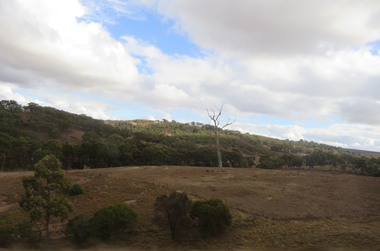
 Ballarat Heritage Services
Photographs - Colour, Clare Gervasoni, Mt Buninyong from the Western Highway, 2019, 31/03/2019
Colour photograph from the Western Highway. mount buninyong -
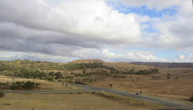
 Ballarat Heritage Services
Photographs - Colour, Clare Gervasoni, Mt Buninyong from the Western Highway, 2019, 31/03/2019
Colour photograph from the Western Highway. mount buninyong -
Beechworth Honey Archive
Map- Albury/Wodonga
(5x) Map centred on Albury and Wodonga. Shows Albury and Wodonga, Murray River, Hume Highway, Murray Valley Highway and Riverina Highway. Scale 1:50,000. Paper is white on back and yellow on front. Ca 1974-1975 Labelled 'Albury series R 652'map, albury, wodonga, paper, beechworth honey