Showing 17895 items matching "hill street"
-
 Bendigo Historical Society Inc.
Administrative record - Lands Office Bendigo - Residence area applications
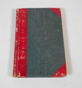
... . On the first page in pencil: Soloman Paul, Hill Street Sandhurst.... Paul, Hill Street Sandhurst. Green and red hardbound book ...Green and red hardbound book. It contains handwritten details of applications of residence area licenses under part II of the land's act 1869. It covers the period from 02-11-1881 to 25/11/1881.Application Register part 2, land act 1869 on the spine. On the first page in pencil: Soloman Paul, Hill Street Sandhurst.land office, residence area licenses -
 Federation University Historical Collection
Book, Dianne Campbell, Ballarat Rate Book Extracts, c2004
... hill street... Street eureka street sturt street hotham street hill street ...This book idetifies the street locations of Ballarat lawyers. dianne campbell goldfields lawyers collection, ballarat rate books, lydiard street, armstrong street, doveton street, lyons street, errard street, mair street, webster street, creswick street, drummond street, dana street, eureka street, sturt street, hotham street, hill street, grenville street, urquhart street, ligar street, seymour crescent, eyre street, neil street, dawson street, skipton street, edward a'beckett, thomas a'beckett, augustus abraham, robert adams, david aherne, henry archer, butler aspinall, herbert barrett, john bethune, john bindon, richard birnie, arthur blackwood, john box, frederick brown, charles browning, hugh macdermott, john ogier, robert le poer trench -
 Federation University Historical Collection
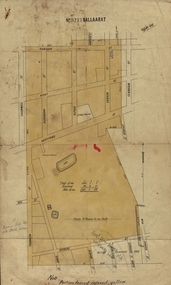
Plan, Ballaarat No 5722, 28/11/1903
... hill street... clarkson street spencer street franklin street hill street grant ...Part of the block shaded yellow on the plan contains Phoenix P-12 School Senior CampusPlan of Ballarat with leae area No 5722 coloured yellow. Plan of the streets around Hertford Street, ballarat. The yellow depicts the area leased (No 5722 Ballarat)mining lease 5722 ballarat, ballarat, hertford street, cromwell street, alexandra street, alfred street, verdon street, clarkson street, spencer street, franklin street, hill street, grant street, albion street, rowlands street, edwards street north, mining, cgt, plans, phoenix p-12 school senior campus -
 Surrey Hills Historical Society Collection
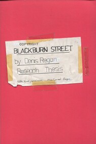
Book, Blackburn Street, ?1980s
... and Environment Study, on Surrey Hills, Blackburn Street... and Environment Study, on Surrey Hills, Blackburn Street... for a Home and Environment Study, on Surrey Hills, Blackburn Street ...A thesis prepared by Mr Denis Regan for a Home and Environment Study, on Surrey Hills, Blackburn Street, and in particular no. 3 Blackburn Street, built in 1920. Includes some photos and house prices.A thesis prepared by Mr Denis Regan for a Home and Environment Study, on Surrey Hills, Blackburn Street, and in particular no. 3 Blackburn Street, built in 1920. Includes some photos and house prices.surrey hills, blackburn street, (mr) denis regan, blackburn estate, elgar's special survey, (mr) fred hemingway oldis, houses, californian bungalow, (mr) william holland, house names, clevedon, (mrs) christina holland, (mrs) carmel regan, (mr) len lewis, (mrs) doreen lewis -
Whitehorse Historical Society Inc.
Document - Ephemera, Envelope, 1/09/1985
... deserting from the army. Lived in Quentin Street, Forest Hill... Forest Hill Cottage Street Forest Hill Forest Hill Envelope ...Envelope posted 2 July 1902 from Sydney to Miss Collins c/o Chrystie, 'Merrylands', Blackburn, Vic. Explanation provided by Jean Uhl that Chrystie was a remittance man from England after deserting from the army. Lived in Quentin Street, Forest Hill (then known as Cottage Street).collins, gordon, chrystie, uhl, jean, quentin street, forest hill, cottage street, forest hill, forest hill -
 Eltham District Historical Society Inc
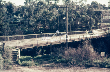
Slide - Photograph, Russell Yeoman, Para Road / Carter Street Bridge over the Plenty River, Briar Hill, c.Jul 1969
... Para Road, Briar Hill became Carter Street, Greensborough... Para Road, Briar Hill became Carter Street, Greensborough ...Bridge over the Plenty River at Briar Hill before widening and alterations. The Plenty River at Briar Hill represented the boundary between the Shire of Eltham and the Shire of Diamond Valley. The bridge was known as the Carter Street Bridge as prior to 1969 Para Road, Briar Hill became Carter Street, Greensborough across the river. It was at this time that the name Para Road was continued and replaced Carter Street.35mm colour positive transparency blue Agfacolour Service plastic mount1969-07, briar hill, carter street bridge, para road, para road bridge, shire of diamond valley, shire of eltham, bridge, plenty river, shire of eltham pioneers photograph collection -
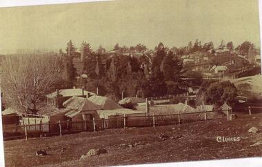 Clunes Museum
Photograph
... HILL STREET, TELEGRAPH HOTEL[KEEBLES] AND GOVERNMENT BRIDGE... OF A PHOTOGRAPH OF CLUNES LANDSCAPE TAKEN FROM HILL STREET, TELEGRAPH ...PHOTOCOPY OF A PHOTOGRAPH OF CLUNES LANDSCAPE TAKEN FROM HILL STREET, TELEGRAPH HOTEL[KEEBLES] AND GOVERNMENT BRIDGE IN CENTRE GROUND, LOOKING TOWARDS CRESWICK AND SMEATON ROAD.local history, photography, photographs, clunes landscape -
![Newspaper Clipping - Digital Image, Protesters fill the gallery 1968 [Britnells Road street construction], 16/04/1968](/media/collectors/4f729f5697f83e03086015b8/items/5eb3a6db21ea670b94fa957d/item-media/5eb3a74221ea670b94faf661/item-fit-380x285.jpg) Greensborough Historical Society
Greensborough Historical SocietyNewspaper Clipping - Digital Image, Protesters fill the gallery 1968 [Britnells Road street construction], 16/04/1968
... britnells road briar hill street construction News clipping, black ...In 1968, a large number of Britnells Road residents attended council expressing concerns over street construction, particularly over losing the rural atmosphere and preservation of trees.An example of concerns over road construction in the formerly 'bush' areas of Diamond ValleyNews clipping, black and white text, 2 scans.shire of diamond valley, mountainview road briar hill, britnells road briar hill, street construction -
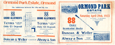 City of Moorabbin Historical Society (Operating the Box Cottage Museum)
Flyer - Ormond Park Estate, Ormond, 1923
... Hill Street (now Hall Sreet)... Road (now McKinnon Road) Hill Street (now Hall Sreet) Jasper ...The train line from the city to Frankston was electrified in 1922 which intensified the sale in the municipality of Moorabbin, particularly land which was in the vicinity of the railway stations.Example of the progress of the Municipality of MoorabbinAdvertising flyer for auction of real estate sales - plan of building blocks for saleOrmond Park Estate, Ormond Auction Saturday 28 April 1923 - 88 residential blocks54jasper road, manchester road (now mckinnon road), hill street (now hall sreet), jasper street (now lewis street), real estate, auction, mckinnon, ormond -
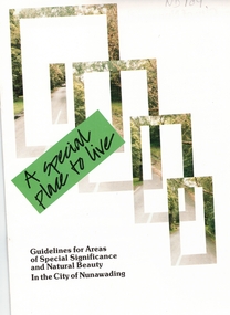 Whitehorse Historical Society Inc.
Pamphlet, A Special place to live, 1985 (addendum 1988)
... hill street... street blackburn laurel grove linum street boongarry avenue hill ...A publication of the City of NunawadingA publication of the City of Nunawading explaining the regulations applying to the Special Residential (Nunawading) Zone No 5. The regulations cover proportions of land which may be built on and identifies trees which must be preserved. An addendum issued in 1988 includes a map of the area and identifies National Trust classified streets in Blackburn and the buffer areas in which less stringent regulations apply.A publication of the City of Nunawadingcity of nunawading, national trust of australia (victoria), special residential (nunawading) zone no. 5, jeffery street, blackburn, laurel grove, linum street, boongarry avenue, hill street, land use, by-laws, town planning, acacia avenue, waratah crescent -
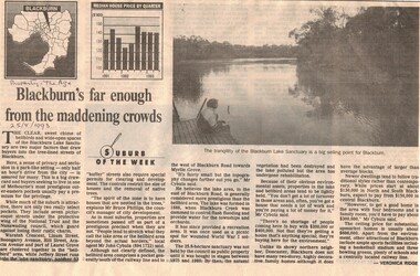 Whitehorse Historical Society Inc.
Article, Blackburn's far enough from the madding crowd, 25/08/1993 12:00:00 AM
... hill street... hill street acacia avenue jeffery street myrtle grove blackburn ...Bell Bird area which is under the protection of the National Trust and the Blackburn Lake areaBell Bird area which is under the protection of the National Trust and the Blackburn Lake area are both select and sought after and houses bring high prices.Bell Bird area which is under the protection of the National Trust and the Blackburn Lake areacity of nunawading, national trust of australia (victoria), waratah crescent, blackburn, linum street, boongarry avenue, hill street, acacia avenue, jeffery street, myrtle grove, blackburn road -
 Whitehorse Historical Society Inc.
Document, Landscape Submission, c 1976
... hill street... blackburn jeffery street hill street boongarry avenue linum street ...A landscape submission written for the National Trust of Australia (Victoria) for Blackburn Lake and the Bell Bird Streets.A landscape submission written for the National Trust of Australia (Victoria) for Blackburn Lake and the Bell Bird Streets. Definitions given of boundaries of the Lake area, ownership, housing and gardens. Photographs and map.A landscape submission written for the National Trust of Australia (Victoria) for Blackburn Lake and the Bell Bird Streets.blackburn lake sanctuary, waratah crescent, blackburn, jeffery street, hill street, boongarry avenue, linum street, laurel grove, acacia avenue, city of nunawading, melbourne and metropolitan board of works, furness park, camberwell grammar school -
 Federation University Historical Collection
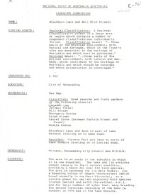
Document - Documents, Documents Relating to the Re-establishment of the Golden Point - Mt Pleasant Progress Association, 1983-1997, 1983-1997
... hill street... hill street urban wildlife corridor south street bluestone ...Mara Gluyas was secretary of this organisation for 11 continuous years (1983-1994), and President Ian McKinnon was President for 9 years from 1983-1992). The inaugural 1983 committee was Ian McKinnon, Mara Gluyas, N. Strange, A. Graham, M. Davidson, M. Adams, Peter Hiscock, Ian Blomeley. The Association was concerned with the advancement of the Ballarat area in general and to promote Golden Point - Mt Pleasant area in particular. Small box with purple lid filled with the constitution, minutes associated with the Golden Point - Mt Pleasant Progress Association, and lists of members.mara glouyas, ian mckinnon, sovereign hill, pearce's park rotunda, elms, tree planting, sovereign hill lookout reserve, christmas carols, mine collapse, former golden point direction indicator, signage, norm strange, golden mount historical mines direction indicator, yarrowee creek tree planting committee, peady street, pearce street, barry davis, nerrina tip, ballarat observatory, carols by candlelight, yarrowee park project, magpie street bbq park, neighbourhood watch, magpie street park, cobden street, pryor street bus shelter, hill street, urban wildlife corridor, south street bluestone gutter, eastern baths site, grant street, street lighting, magpie street, letterhead, aboriginal advancement league, golden point primary school, sunnyside woollen mill, ballarat west goldfields, fred hunt, kerry daniell, craig ford, jack colin greville, jack colin greville plaque at mt pleasant lookout, golden point school oval -
 Greensborough Historical Society
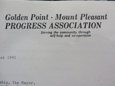
Poster - Planning Document, City of Heidelberg et al, Subdivision Plan # 5 - Crown Portion 17, Parish of Nillumbik, and Crown Portion18, Parish of Keelbundoora, 1925-1972
... - damaged], Parish of Nillumbik, Springfield Street, Turner Street... of heidelberg Greensborough briar hill main street greensborough Stamped ...Subdivision Plan # 5 - Side 1: Crown portion [unknown - damaged], Parish of Nillumbik, Springfield Street, Turner Street Briar Hill,1963 amended 1972 and Crown Portion17, Parish of Keelbundoora: Thoona Grove, Donald Street. Paterson Crescent Greensborough, 1963 amended 1967. Side 2: Parish of Keelbundoora, Crown Portion 18: Boyd Street, Kempston Street Greensborough 1925; and Main Street Greensborough. An example of hard copy subdivision plans from the Greensborough area. Mainly from the Shire of Diamond Valley era (1964-1994).Plan (2 sided) mounted on heavy card. Stamped and handwritten Council permissions, dates and other details.subdivision plans, city of heidelberg, greensborough, briar hill, main street greensborough -
 Greensborough Historical Society
Article - Memoir, June Roberts, Brian and June Roberts at 'Blackjack', 1956o
... Brian and June Roberts moved to Hume Street Briar Hill... to Hume Street Briar Hill as newlyweds. June's story recounts ...Brian and June Roberts moved to Hume Street Briar Hill as newlyweds. June's story recounts the development of their home on the Plenty River and the friendships with neighbours. A primary source recollection of Greensborough in the mid to late 20th century.11 typed pages.june roberts, brian roberts, briar hill, blackjack, hume street, suburban life -
 Flagstaff Hill Maritime Museum and Village
Photograph - Military, Ca. 1887
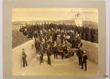
... Flagstaff Hill, Merri Street, Warrnambool, Victoria ...Warrnambool had an active group of military volunteers prepared to defend the coast of Victoria.This photograph is historically significant to Warrnambool's military history.Photograph, sepia, mounted on brown card, depicting Warrnambool Battery opening at Flagstaff Hill and a group of uniformed artillery men around the cannon. The background had the Lower Lighthouse. Inscription on back.Handwritten text on back: "1887"flagstaff hill, warrnambool, maritime museum, maritime village, great ocean road, shipwreck coast, militia, volunteer corps, defence, army, military, cannon -
 Flagstaff Hill Maritime Museum and Village
Photograph - Military, First Warrnambool Battery on Flagstaff Hill, ca. 1868
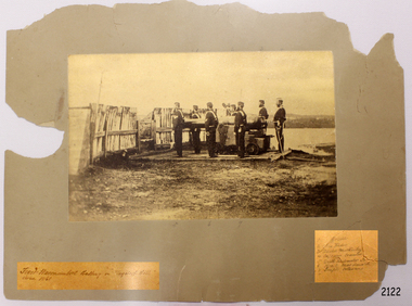
... Flagstaff Hill, Merri Street, Warrnambool, Victoria ...There was an active Volunteer Corps in Warrnambool in the 1800s. This photograph shows a group off military men on Flagstaff Hill ready for action. The names are listed on the card, handwritten in pencil: 1. Gorrie 2. Chris Hider 3. David McKinley 4. Captain Cramer 5. Drill Instructor (cannot read name) 6. R.A.C. Macdonald 7. Joseph GladstoneThe militia played a significant role in being prepared to defend the Warrnambool district.Photograph, sepia, mounted on brown card. Depicts the First Warrnambool Battery on Flagstaff Hill. Seven uniformed figures stand beside a cannon mounted on a wooden, waist high carriage. The cannon is aimed between a gap in a timber fence. The lower edge of the card has two labels with handwritten inscriptions; one is the photograph title, the other is a list of seven names written in pencil Photograph is dated ca. 1868. Left hand side: "First Warrnambool Battery on 'Flagstaff Hill'" Right hand side: list of names written in pencil: "1. Gorrie 2. Chris Hider 3. David McKinley 4. Captain Cramer 5. Drill Instructor (cannot read name) 6. R.A.C. Macdonald 7. Joseph Gladstone"flagstaff hill, warrnambool, maritime museum, maritime village, shipwreck coast, great ocean road, militia, volunteer corps, cannon, gun, firearm, first warrnambool battery, warrnambool battery, defence, gorrie, chris hider, david mckinley, captain cramer, drill instructor, r.a.c. macdonald, joseph gladstone -
 Flagstaff Hill Maritime Museum and Village
Photograph - Military, Volunteer Corp, mid-1800s
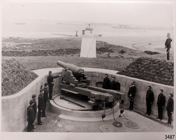
... Flagstaff Hill, Merri Street, Warrnambool, Victoria ...This photograph relates to the early group of the Volunteer Corps preparing to defend their country.The photograph is a significant record. It shows a point in time when local volunteers were prepared to defend the south west coast of Victoria.Black and white photograph of Volunteer Corp firing the gun on Flagstaff Hill. flagstaff hill, warrnambool, flagstaff-hill-maritime-museum, photograph, volunteer corp, gun on flagstaff hill, fortifications volunteer corps., fortifications, volunteer corps, maritime museum, maritime village, great ocean road, shipwreck coast, militia, barracks -
 Flagstaff Hill Maritime Museum and Village
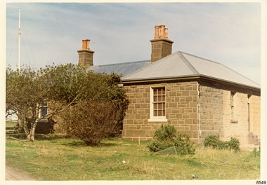
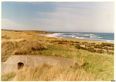
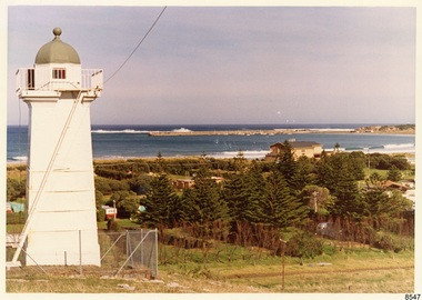
Photograph - Historical, Flagstaff Hill, The Lighthouse Keeper’s Cottage showing re-roofing carried out by Council, 1970s
... Flagstaff Hill, Merri Street, Warrnambool, Great Ocean Road ...The coloured photograph shows the Lighthouse Keepers' Quarters at Flagstaff Hill, Warrnambool. The building was erected in the 1850s on Middle Island, Lady Bay. It was relocated to its current location in the late 1870s along with the two lighthouses, the chart room and the privy. The Warrnambool City Council replaced the iron roof on the cottage in the 1970s and further work has since been carried out. The picture shows the poor condition of the stonework on the right hand side of the cottage. After the cottage ceased to be used by lighthouse keepers, it was rented out by various organisations and later became disused. The Historical Society requested the re-connection of power. The right hand side of the cottage was repurposed for use by Flagstaff Hill Maritime Museum and Village. in the 2020s it was restored and fitted out as the Alexander Farncombe room, which is used for temporary exhibitions. This photograph, a print, is one of a set of five that show the site of Flagstaff Hill. It is presumed to have been taken by John Lindsay, Founding Director of Flagstaff Hill Maritime Museum and Village. One of the photographs in the set has the pencil inscription "Photo J Lindsay". It was taken in the early 1970s during the initial stages of the development of Flagstaff Hill as a Museum and Maritime Village. The photographs belonged to the donor's grandparents, who lived in the Warrnambool district of Allansford/Naringal. The photograph is a record of the Lighthouse Keepers' Quarters at Flagstaff Hill Maritime Museum and Village before its development and opening in 1975. It shows the condition of the building at the time and some of the recent re-roofing. The photograph is significant for recording the condition of the original heritage listed building at that point in time.Coloured photograph, glassy print, one of a set of five. Photograph shows the Lighthouse Keepers' Quarters, focused on the Assistant's Quarters on the right. It shows the a new iron roof that had been installed by the Warrnambool City Council, and the condition of the bluestone,walls. There are clay chimney pots on the two chimneys. A set of steps are at the entry on the right hand side. The flagstaff is on the left of the photograph. The photograph's paper has the printer's watermark on the back. The early 1970s picture is presumed to have been photographed by John Lindsay, Warrnambool.Label on the back: "THE BLUESTONE COTTAGE SHOWING RE-ROOFING CARRIED OUT BY COUNCIL. The Historical Society has requested Council to have S.E.C. power re-connected"flagstaff hill maritime museum and village, warrnambool, maritime museum, shipwreck coast, 1970s, photograph, lady bay, flagstaff hill site, john lindsay, cannon emplacement, middle island, flagstaff, lighthouse keepers' quarters, lighthouse keepers' residence, alexander farncombe, re-roofing, s.e.c. connection -
 Flagstaff Hill Maritime Museum and Village
Photograph - Historical, Flagstaff Hill, Warrnambool Garrison Fortifications looking towards the Moyjil (Point Ritchie), 1970s
... Flagstaff Hill, Merri Street, Warrnambool, Great Ocean Road ...The photograph shows the location of the concrete, horseshoe shaped gun emplacement erected for the cannons. It is part of the Historic Precinct on Flagstaff Hill. The area was accessed either through the space between the Lighthouses (through the cottage grounds) or a service entrance, past the iron huts used by the Lands Department. This photograph, a print, is one of a set of five that show the site of Flagstaff Hill. It is presumed to have been taken by John Lindsay, Founding Director of Flagstaff Hill Maritime Museum and Village. One of the photographs in the set has the pencil inscription "Photo J Lindsay". It was taken in the early 1970s during the initial stages of the development of Flagstaff Hill as a Museum and Maritime Village. The photographs belonged to the donor's grandparents, who lived in the Warrnambool district of Allansford/Naringal. The photograph is a record of the site and surrounds of Flagstaff Hill Maritime Museum and Village before its development and opening in 1975. It shows the east side of the Surfside Holiday Park in its earlier days. The photograph is significant for recording the location and condition of the original concrete cannon emplacement on the Hill.Coloured photograph, glassy print, one of a set of five. Photograph shows the original site of one of the gun emplacements for the cannons, cannons Historical, looking towards the Moyjil, ,Point Ritchie and overlooking Lady Bay, Warrnambool. The horseshoe shaped concrete gun emplacement is in the foreground on the grassed slopes overlooking the Bay. The site and ablution block of the Surfside Holiday Park is centre right. The left shows the sore of Lady Bay with the cliffs of the Southern Ocean in the distance. The photograph's paper has the printer's watermark on the back. The early 1970s scene is presumed to have been photographed by John Lindsay, Warrnambool.Label on the back: "FIRST GUN EMPLACEMENT LOOKING TOWARDS THE HOPKINS / This is the original site of one of the cannons overlooking the Bay. Access to this area could be between the light-houses (throught the cottage grounds), or a service entrance - past the iron huts used by Lands Department."flagstaff hill, flagstaff hill maritime museum and village, warrnambool, maritime museum, maritime village, great ocean road, shipwreck coast, 1970s, photograph, gun emplacement, surfside holiday park, lady bay, hopkins river, flagstaff hill site, john lindsay, concrete gun emplacement, cannon emplacement, original emplacement -
 Flagstaff Hill Maritime Museum and Village
Photograph - Historical, Flagstaff Hill, John Lindsay, View of the Bay from the south boundary of the Ports and Harbours land, 1970s
... Flagstaff Hill, Merri Street, Warrnambool, Great Ocean Road ...The photograph shows the view of the shore and Lady Bay with the Breakwater and Middle Island all visible. It was taken to show that the Flagstaff Hill area was unlikely to have any further development between it and the Bay, with the view of development of the Flagstaff Hill Maritime Museum and Village. This photograph, a print, is one of a set of five that show the site of Flagstaff Hill. The photographer was John Lindsay, Founding Director of Flagstaff Hill Maritime Museum and Village, with the words "Photo J Lindsay" on the back. It was taken in the early 1970s during the initial stages of the development of Flagstaff Hill as a Museum and Maritime Village. The photographs belonged to the donor's grandparents, who lived in the Warrnambool district of Allansford/Naringal. The photograph is a record of the site and surrounds of Flagstaff Hill Maritime Museum and Village before its development and opening in 1975. It shows the Surfside Holiday Park, Surf Lifesaving Club, and the Breakwater. The photograph is significant for recording the location and condition of the Lower Lighthouse on the Hill.Coloured photograph, glassy print, one of a set of five. Flagstaff Hill's Lower Lighthouse is in the foreground above the Surfside Holiday Park. To the right of centre is the Surf Lifesaving Club. In the background is Lady Bay and the Breakwater and Middle Island, with the Southern Ocean the other side. The photograph's paper has the printer's watermark and a pencilled inscription on the back. The early 1970s scene was photographed by John Lindsay, Warrnambool.Label on the back: "VIEW OF THE BAY FROM the southern boundary of the Ports and Harbours land. No development below this area is likely to obstruct the view, due to the steep grade down to the Southern boundary of Flagstaff Hill property." Handwritten in pencil: "Photo J Lindsay"flagstaff hill, flagstaff hill maritime museum and village, warrnambool, maritime museum, maritime village, great ocean road, shipwreck coast, 1970s, photograph, surfside holiday park, lady bay, flagstaff hill site, john lindsay, lower lighthouse, lower light, surf lifesaving club, breakwater, middle island, ports and harbours -
 Flagstaff Hill Maritime Museum and Village
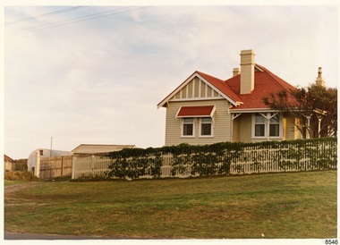
Photograph - Historical, Flagstaff Hill, Harbourmaster’s Quarters, 1970s
... Flagstaff Hill, Merri Street, Warrnambool, Great Ocean Road ...The photograph shows a cottage, Harbourmaster’s quarters that still stands on the east of the Lady Bay Lighthouse and Historic Precinct at Flagstaff Hill in Warrnambool. The name was changed to the Lighthouse Lodge, and today guests can stay at the property. This photograph, a print, is one of a set of five that show the site of Flagstaff Hill. It is presumed to have been taken by John Lindsay, Founding Director of Flagstaff Hill Maritime Museum and Village. One of the photographs in the set has the pencil inscription "Photo J Lindsay". It was taken in the early 1970s during the initial stages of the development of Flagstaff Hill as a Museum and Maritime Village. The photographs belonged to the donor's grandparents, who lived in the Warrnambool district of Allansford/Naringal. The photograph is a record of the site and surrounds of Flagstaff Hill Maritime Museum and Village before its development and opening in 1975. It shows the cottage on the east of the Lighthouse Complex,. The building is now known as Lighthouse Lodge. The photograph is significant for recording the location and condition of the residence on the Hill.Coloured photograph, glassy print, one of a set of five. Photograph shows the cream timber cottage, Harbourmaster’s quarters to the east of the lighthouse complex at Flagstaff Hill, Warrnambool. On the left of the red roofed residence are iron buildings used, at the time, by the Lands Department. The photograph's paper has the printer's watermark on the back. The early 1970s photograph is presumed to have been by John Lindsay, Warrnambool.Label on the back: "WOODEN RESIDENCE TO THE EAST OF THE PROPERTY / The gun emplacements are immediately behind, and the iron huts to the left rear of the residence are used by the Lands Department who plan to vacate, for other premises."flagstaff hill, flagstaff hill maritime museum and village, warrnambool, maritime museum, maritime village, great ocean road, shipwreck coast, 1970s, photograph, flagstaff hill site, john lindsay, cannon emplacement, residence, wooden residence, timber residence, iron huts, lands department -
 Flagstaff Hill Maritime Museum and Village
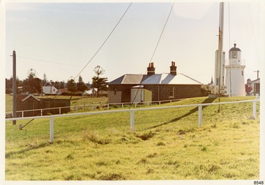
Photograph - Historical, Flagstaff Hill, The Lighthouse keepers cottage, from the gun emplacements, looking towards the town centre, 1970s
... Flagstaff Hill, Merri Street, Warrnambool, Great Ocean Road ...The photograph shows the back of the Lighthouse Keeper's Quarters and the privy, Upper Lighthouse and Flagstaff, and the condition and placement of these buildings and the street. The note on the back points out the uniqueness of the double-sided toilet building, and the well at the back of the Quarters. This photograph, a print, is one of a set of five that show the site of Flagstaff Hill. It is presumed to have been taken by John Lindsay, Founding Director of Flagstaff Hill Maritime Museum and Village. One of the photographs in the set has the pencil inscription "Photo J Lindsay". It was taken in the early 1970s during the initial stages of the development of Flagstaff Hill as a Museum and Maritime Village. The photographs belonged to the donor's grandparents, who lived in the Warrnambool district of Allansford/Naringal. The photograph is a record of the site and surrounds of Flagstaff Hill Maritime Museum and Village before its development and opening in 1975. It shows the Heritage Listed Precinct; the Lighthouse Keepers' Quarters, the privy and the Upper Lighthouse. The photograph is significant for recording the location and condition of the buildings on the hill, erected in the 1870s.Coloured photograph, glassy print, one of a set of five. Photograph shows the back of the Lighthouse Keepers' Cottage or Residence, the privy and the Upper Lighthouse. The photograph's paper has the printer's watermark on the back. The early 1970s scene is presumed to have been photographed by John Lindsay, Warrnambool.Label on the back: "THE COTTAGE, FROM THE GUN EMPLACEMENTS, LOOKING ACROSS THE PORTS AND HARBOURS AREA / The two-doored toilet is of interest, and the covered well is between the toilet and the rear door of the cottage."flagstaff hill maritime museum and village, warrnambool, great ocean road, shipwreck coast, 1970s, photograph, flagstaff hill site, john lindsay, lighthouse keepers' cottage, lighthouse keepers' residence, privy, upper lighthouse, upper light, lighthouse keepers' quarters -
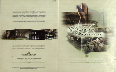 Federation University Historical Collection
Booklet, From Academy to University, 2001, 2001
... camp street hill... Street Hill."... anderson robert hook david james terry lloyd camp street hill ...Four page signed copy of a booklet concerning the University of Ballarat Art Campus at Camp Street. On back page - "Amidst the fevered atmosphere of multi-cultural settlement and the rush for gold, Ballarat's passion for the arts was born. The founding schools of art have evolved over 130 years to forge a proud identity in the University of Ballarat's 'New School of Arts'. The arts have returned to Camp Street Hill."arts academy, camp street, autographs, david karmouche, kerry cox, pamela davies, rosie mcgregor, tim broome, bill pryor, pater r. wilson, gerry anderson, robert hook, david james, terry lloyd, camp street hill -
 City of Kingston
Pamphlet - Colour, Stillwell and Co, The Hill Estate Highett Great Subdivisional Auction Sale, 1917
... Handwritten in grey pencil on reverse: Hill Street... on reverse: Hill Street / Jamieson Handwritten in blue pencil ...Sales plan for land in the suburb of Highett, bounded by Point Nepean Road and incorporating Sandford Street, Turner Road, Alfred Street, Peace Street and Tennyson Street. .The developing urban area of Highett within the City of Kingston. This land sale pamphlet illustrates the subdivision of land within the municipality and the changing demographic of the district as new houses are constructed.Colour pamphlet advertising subdivisional auction sale of the Hill Estate Highett. Incorporates a map of the estate bordered by Point Nepean Road and encompassing Sandford Street, Turner Road, Alfred Street, Peace Street and Tennyson St. Handwritten in grey pencil on reverse: Hill Street / Jamieson Handwritten in blue pencil on reverse: The Hill Estate Handwritten in blue pencil on subdivision map: [tick] [on majority of properties marked on map]highett, land sales, estate -
 Federation University Historical Collection
Plan, Ballarat East, 1957, 1957
... ) Bakery Hill, Humffray Street, Victoria Street, Ballarat Youth... hill humffray street victoria street st paul's anglican church ...Dr George Clendinning and others were trustees of the Church of England (St Paul's) A number of enlargements of the Ballarat East maps. .4) Bakery Hill, Humffray Street, Victoria Street, Ballarat Youth Council .5) Specimen Vale, Victoria Street, Eureka Street, Housing Commission .10) - Tomber Reserve, York Street, Spencer Street, Bennett Street, Wilson Street, Rodier Street, Richard Street, Fussell Street, Turpie Street, Stockade Street, Ballarat Rifle Range Lal La Street, Clayton Street, Eureka Street Sheet 2 - Yarrowee Creek, High Street, Dinney's Dam, Binney Street, Oliver Street, Humffray Street, Morres Street, Finch Street, Scotts Parade, Rice Street, HOrnby Street, Queen Street, Newman street, King Street, Napier Street, Sim Street. Sheet 3 - Russell Square, Victoria Street, Orphan Asylum, Ballarat Orphanage, Lofven Street, Haines Street, Yarrowee Creek, Ching Who Coey, Chinese, Stawell Street, Rice Street, Lane Street, Humffray Street, Nelson Street, Coffield Street, Morres Street, Western Highway, Rodier Street, Scott Parade, Canterbury Street Sheet 4 - Orphan Asylum, Ballarat Orphanage School, Fortune Street, Scotts Parade, Water Street, Ritchie Street, Humffray Street, Brophy Street, Thompson Street, Victoria Street,Humffray Street Church of England Reserve, Strickland Parade. Mount Xavier Recreation Reserve, Charlesworth Street Catholic Church Reserve. Sheet 5 - Western Highway, Mount Street, Fortune Street, Finlay Street, Jones Street, Ryan Street, Water Street, Brandbury Street, Humffray Street. Sheet 6 - Barkly Street, Ebden Street, Grenville Street, Cameron Street, Peel Street, Young Street, Victoria Street, Steinfeld Street, Haymes Street, Bond Street, Anderson Street, Eastwood Street, Mair Street, East Street, Haymes Crescent Sheet 7 - Murphy Street, Queen Street, Dyte Parade, Princes Street, Midland Highway, York Street, Dodds St, Wilson St Otway Street, Specimen vale, King Street, Gray Street, Little Dodds Street, Eureka Street. Sheet 9 - Richards Street, Fussell Street, Stockade Street, Orphan Asylum, Ballarat Orphanage, Elford Street, Russell Street, Ross Street, Charlesworth Street, Lalor Street, Stockade Street, Wilson Street, York Street, Eureka Street Sheet 10 - Eureka Street, York Street, Elford Street, Wilson Street, Mount Street, Turpie Street, Timber Reserve, Mount Xavier Sheet 11 - Yarrowee Creek, Humffray Street, Barkly Street, Morton Street, Cobden Street, Morton Street Wesleyan Church, Pryor Street, Albion Street, Bradshaw Street, Ballarat Woollen Mills, Tannery, Mount Pleasant. Sheet 12 - Magpie Street, Grant Street, Gladstone Street, Cobden Street, Fraser Street, Grenfell Street, Robertson Street, Bond Street, Barkly Street, Vine Street, Sovereign Hill, Ballarat Observatory, Pearce Street, Bond Street. Sheet 13 - Murphy Street, Larter Street, midland Highway, Geelong Road, gales Street, Lal Lal Street, Clayton Street, Dodds Street, Elsworth Street Sheet 14 - Eureka Street, Eureka Stockade Memorial Park, Eureka Stockade Reserve. York Street, Joseph Street, Kline Street, Charlesworth Street, Chamberlain Street, Trevor Street, Belford Street, Queen Street, Murray Street, Eureka Tiles, Orphan Asylum, Ballarat Orphanage. Sheet 18 - Scotts Parade, Stawell Street, Fortune Street, Victoria STreet, Railway Line, Haines Street, Eureka Street, Elford STreet, Brophy Street, York Street, Clayton Street, Elsworth Street, Barkly Street, Humffray Street, Midland Highway, Princes Street ballarat youth council, ballarat east, bakery hill, humffray street, victoria street, st paul's anglican church, humffray street state school -
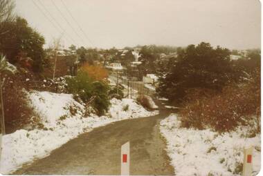 Clunes Museum
Photograph
... SNOW ON CAMERON STREET HILL, CIRCA 1987... history photography photographs snow SNOW ON CAMERON STREET HILL ...SNOW ON CAMERON STREET HILL, CIRCA 1987local history, photography, photographs, snow -
Clunes Museum
Document - INSURANCE POLICY, 1885
... THE SWAINSON FAMILY LIVED IN HILL STREET, CLUNES.... THE SWAINSON FAMILY LIVED IN HILL STREET, CLUNES. local history ...THE SWAINSON FAMILY LIVED IN HILL STREET, CLUNES.QUEEN INSURANCE - FIRE POLICYlocal history, swainson family -
 Stawell Historical Society Inc
Photograph, Railway Cutting Stawell 1874, 1874
... State Library NSW 63789 Hill Street Cutting... grampians State Library NSW 63789 Hill Street Cutting Transport ...State Library NSW 63789 Hill Street CuttingThree workers on Rail tracks in cutting and two on top of Cuttingtransport, railways -
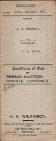 Bendigo Historical Society Inc.
Document - H.A. & S.R. WILKINSON COLLECTION: CONTRACT OF SALE
... ) for land situate No.39 Hill Street, Bendigo being residence area...) and G.A. Smith (buyer) for land situate No.39 Hill Street, Bendigo ...This business was owned by father and son, Henry Archibald Wilkinson and Samuel Ronald "Ron" Wilkinson. Henry (1882-1954) was born in Shepparton and died in Bendigo. He was married to Grace Hovendon in 1908. Samuel Ronald "Ron" (1914-1995), Henry's son, was married to Florence Jean McKerlie in 1937.Conditions of sale by private contract dated 17th October, 1932 between A.G. McKenzie (seller) and G.A. Smith (buyer) for land situate No.39 Hill Street, Bendigo being residence area allotment 447 section K, together with weatherboard dwelling and all sundry.organization, business, h.a. & s.r wilkinson real estate