Showing 1787 items
matching intersection
-
 Stawell Historical Society Inc
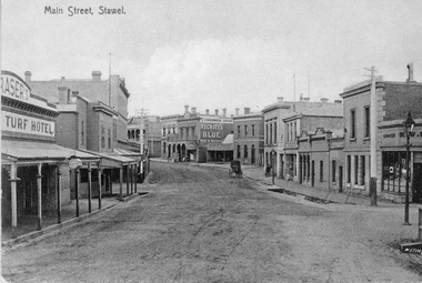
Photograph, Main Street Stawell looking West across Layzell Street intersection c 1900's
Main Street Stawell looking West across Layzell Street intersection. J Chadwick Drapers sign visible in centre of photo. Patrick Street runs off to the left of the photo behind wooden building the Foresters Hotel . Turf Hotel on left of photo. Horse drawn buggy near centre of photo. Circa 1900's. Similar to as 6730-2 & 0539PostcardMAIN STREET STAWELL - on front On Rear - Dear Viola. Another one of the Main Street. Rollo?stawell businesses streetscape -
 Melbourne Tram Museum
Newspaper, The Sun, Accident - Gertrude St Fitzroy at the intersection of Napier S, 24/04/1969 12:00:00 AM
Newspaper Clipping - set of one clippings adhered to one side of a sheet of ruled quarto paper with punched holes on the left hand side - from The Sun Newspaper 24/4/1969 about an accident to a sliding door car in Gertrude St Fitzroy at the intersection of Napier St, the previous day. Gives details of injuries and the truck driver. Tram has the route number 89 and a Tuckfields Ty-Nee-Tip Teas advert on the side.trams, tramways, accidents, drivers, route 89, gertrude st -
 Melbourne Tram Museum
Photograph - Digital Image, Kevin O'Reilly, intersection of Elizabeth and Victoria Streets from the North, c1920, c1920
Image from CD (Compact Diskette for use in computers) - see Reg Item 135. Image titled "Eliz St" on CD, of looking at the intersection of Elizabeth and Victoria Streets from the North, c1920, between Swanston and Queen Streets. Has the Myer Lonsdale St store in the photograph at the top. Has a number of cable cars in the photo, including a bogie trailer inbound in Elizabeth St. Image has a number of watermarks showing up.trams, tramways, melbourne, elizabeth st, victoria market, victoria st -
 Melbourne Tram Museum
Postcard, Murray Views, W6 or W7 at the intersection of Bourke St and Elizabeth St, late 1950's
Postcard photo of a W6 or W7 at the intersection of Bourke St and Elizabeth St, late 1950's or early 1960's. Photo looking east along Bourke St. Has the Myer's, Coles, London Stores and other buildings in the background. has a Holden station wagon waiting to do a Hook turn. Divided back with places for stamp, address, correspondence and details with makers details "Murray Views of Gympie Qld, No. 2, Bourke St. Melbourne, from an Ektachrome photograph.trams, tramways, bourke st, elizabeth st -
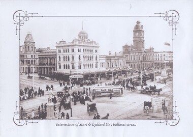 Ballarat Tramway Museum
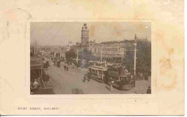
Photograph - Black & White Photograph/s, Intersection of Sturt & Lydiard Sts Ballarat, c1907
Titled "Intersection of Sturt and Lydiard Streets, Ballarat circa:." shows an ESCO tram, without windows turning from Sturt St into Lydiard St North with many people lining the streets prior to a parade. Has a number of horse drawn vehicles in photo taken from the Post Office or Summerscales Office. In photo are Craigs Hotel, National Mutual Life building and the Town Hall. See item 8247 for a colour postcard of this image. Yields information about Sturt and Lydiard St during an event.Black and white historic photograph downloaded from a picture resource website within a decorative frame and printed with an inkjet printer. trams, tramways, sturt st, lydiard st, town hall, esco -
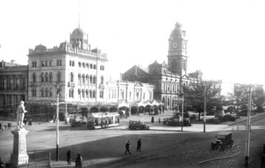
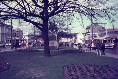 Ballarat Tramway Museum
Slide - 35mm slide/s - set of 3, Dave Simpson, trams at the intersection of Sturt and Lydiard St - City terminus, late 1960's early 1970's
Yields information about the intersection of Sturt and Lydiard Sts tramway centre and Boer War monument.Set of three 35mm slides - AGFA dark blue / white plastic mounts of trams at the intersection of Sturt and Lydiard St - City terminus. 1 - view from the central median on the west side of Lydiard St, looking East with the Commonwealth Bank, Post Office, with many passengers at the location. The Boer War monument /statue is in the centre part of the photograph. 2 - No. 14 about to turn into Lydiard St North/ The short tram stop and End of Section sign are adjacent to the tram. 3 - Tram waiting at the north side tram stop - has a Twin Lakes and Cinzano sign. Has the ANZ bank and the SEC offices in the background.tramways, trams, sturt st, city, lydiard st, passengers, signs, tram 14 -
 Ballarat Tramway Museum
Photograph - digital Images, Sovereign Hill and Gold Museum, Sebastopol type tram travelling on the south side of Sturt St at the Lydiard St intersection, 2014
Copy of an image and associated text for reference purposes only. Original document held by Sovereign Hill and Gold Museum. See the related document file for more details of holdings. The Museum does not hold the original of the document. Image from a printed sepia toned postcard of a Sebastopol type tram travelling on the south side of Sturt St at the Lydiard St intersection. Photo mid 1930's, has a taxi waiting at the median strip with other cars in the photograph as well. In the background is the Town Hall and National Mutual buildings. The statue of Robert Burns is on the left hand side of the image. The original postcard might give the tram number. Note the keywords given in the document file are incorrect.trams, tramways, sturt st, sebastopol type, lydiard st, taxis -
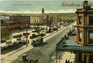 Ballarat Tramway Museum
Postcard, WTP, ESCo tram near the intersection of Doveton St. and Sturt St, 1905
Photo appears to be taken soon after opening of the electric trams, as the tramway is well paved compared to the rest of the street which shows vehicle tracks etc. Small horse drawn vehicle crossing in front of the photograph. Shows buildings along the north side of Sturt St. and the building at the SE corner of Doveton St. ESCo tram has destination board on the front dash of the tram.Yields information about the appearance of Sturt St soon after the opening of the electric tram service in Ballarat.Printed colour postcard of an ESCo tram near the intersection of Doveton St. and Sturt St. travelling west along the south side of Sturt Street. Titled "Sturt Street, Ballarat" in the top left-hand corner and overprinted, embossed in gold, with the words "Christmas Greetings". On the rear of the postcard is a letter to Miss Hancock, Pitt St. Rockdale NSW, from a W.H. Nicholls. Message in pencil, address in ink. Postcard made by "WTP" Has a "Victoria One Penny" stamp. Does not appear to have been cancelled. Assumed used in 1905. On the rear of the second copy is a note to Miss Gibbs of Mole Creek Tasmania, dated 22/12/1907, sent from South Melbourne. See Reg. Item 834 for a scanned copy of another version of this postcard.Handwritten letter on card.trams, tramways, esco, sturt st, postcards, doveton st -
 Stawell Historical Society Inc
Photograph, Main Street Stawell looking West across Layzell Street intersection c 1900's
Main Street Stawell looking West across Layzell Street intersection. J Chadwick Drapers sign visible in centre of photo. Patrick Street runs off to the left of the photo behind wooden building the Foresters Hotel . Turf Hotel on left of photo. Horse drawn buggy near centre of photo. Circa 1900's. Same as 6730-2 & 0539 Turf Hotel on left, Forester Hotel on corner of Patrick Street, verandah of D. Fern Hotel / Times Office, McKeller Building. Across Main street in distance is J Allingham Draper, New Union Bank, Chadwick Drapers / Liddiard's , D. Telford Produce, Bank of Victoria, Oriental Bank / O'Driscoll's, J. Punchard furniture, A.B. Clemes, Bennett & Briston, Union Bank Australia, R.W, Dane Grocer on corner of Layzell Street. Same as 6730-2 0539 PostcardMAIN STREET STAWELL - on front stawell businesses streetscape -
 Melbourne Tram Museum
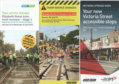
Pamphlet, Public Transport Victoria (PTV), "Tram service changes Elizabeth St tram track renewal stage 1", "Tram service changes - Routes 70 and 75 - Intersection of Power St, Wallen Road and Riversdale Road Burnley", "Your new Victoria Street accessible stops", 2012 and 2016
Set of three pamphlets advising of changes to tram services for the renewal of tram track works. All give the relevant service changes and maps. .1 - "Tram service changes Elizabeth St tram track renewal stage 1" - April 2012 - 2 fold DL .2 - "Tram service changes - Routes 70 and 75 - Intersection of Power St, Wallen Road and Riversdale Road Burnley" - June to July 2012 - 3 fold DL .3 - "Your new Victoria Street accessible stops" - Feb,. 2016 - 4 fold DL, including a Vietnamese translation. Details work between Hoddle and Church Streets. .4 - Route 70 - Swan St Burnley track renewal - 9 to 11 Jun 2012 - 3 fold DL 5 - Fitzroy St and The Esplanade - superstops.11/6 to 17/6/2011 - 3 fold DL Produced by Public Transport Victoria and Yarra Tramstrams, tramways, public transport, tram stops, elizabeth st, hawthorn, riversdale junction, wallen rd, route 70, route 75, route 109, victoria st, route 12, swan st, esplanade, route 70, fitzroy st -
 Ballarat Tramway Museum
Postcard, ESCo tram just past the intersection of Doveton St. and Sturt St
Photographically printed black and white postcard with an impressed image of an ESCo tram just past the intersection of Doveton St. and Sturt St. travelling east along the north side of Sturt. Street towing a heavily laden horse tram as a trailer. Photo appears to be taken soon after opening of the electric trams, as the tram does not have any destination box above the driver. Possibly summer 1905/1906. Numerous people in the street, some horse drawn vehicles in the photograph. Shows buildings along the south side of Sturt St. and part of the verandah of the building at the NE corner of Doveton St. For a list and description of the same base image see Archives file - "Notes on ESCo Tram towing a heavily loaded trailer" On rear is places for correspondences stamp, address. Addressed to Miss E. Freeman, in Dunedin NZ, with a hand written message. Posted in Melbourne on 28/10/1908. Titled "Sturt Street, Ballarat" along bottom edge with "47" in bottom left hand corner of image.. trams, tramways, sturt st, postcards, esco, doveton st -
 Ballarat Tramway Museum
Postcard, ESCo tram just past the intersection of Doveton St. and Sturt St, c1906
Demonstrates aspects of Ballarat tramway operation with horse tram trailers, Sturt St buildings, yields information about the appearance of Ballarat in colour.Colour postcard, presented within a wooden framed image of an ESCo tram just past the intersection of Doveton St. and Sturt St. travelling east along the north side of Sturt. Street towing a heavily laden horse tram as a trailer. Photo appears to be taken soon after opening of the electric trams, as the tram does not have any destination box above the driver. Possibly summer 1905/1906. Numerous people in the street, some horse drawn vehicles in the photograph. Shows buildings along the south side of Sturt St. and part of the verandah of the building at the NE corner of Doveton St. For a list and description of the same base image see Archives file - "Notes on ESCo Tram towing a heavily loaded trailer" On rear is "Made in Germany", areas for correspond, a Victoria one penny postage stamp, an din the bottom right hand corner, "09 3851" The card has been addressed to a Miss Seymour "Larramea", Mulwala NSW. Has a handwritten note to her sister (signed Flo?) about a trip arrangements to Melbourne and other details. Date 13 April, but year not apparent. Has been postmark, Melbourne (appears)In pencil along top edge "9269 V and $5"trams, tramways, sturt st, trailers, horse tram, town hall, esco -
 Yarra City Council
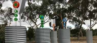
Artwork, other - Installation/Sculpture, Troy Innocent, Joel Collins, Indae Hwang, Yun Tae Nam, Drop Zone, 2011
'Drop Zone', is set in an imagined future where decreasing water availability has affected us more dramatically than anyone predicted. The water shortage has become so severe that we have to access water on a first-come first-serve basis, from military-like water ‘drop zones’, like this one, made from modified rain water tanks. These tanks function on three levels: Collected rain water causes the totem sculptures to rise and bloom; evaporation causes the totem sculptures to fall; and an anemometer (device that measures wind speed) drives a process that plays the tank like a giant drum, tuned by the amount of water contained within. This artwork envisions a future for Australia where the impact of decreasing water availability has had a more dramatic effect than any of the predictions. The shortage is so severe that military-like water ‘drop zones’, constructed of modified rainfall storage tanks have been established across the public parks of the City of Yarra for access on a first come, first serve basis. However, as the water is only replenished through rain catchment the tanks may only offer infrequent relief for the City of Yarra residents, standing as hollow reminders of the effects of inaction on the shaping of sustainable national water use.'Drop Zone' was one of three public art works installed in Yarra, in 2011, under the banner of The Environmental Public Arts Project which responded to key features of Council's Environment Strategy: 'Towards Local Sustainability 2008-2020.' The aims of this project included activating public spaces in new and creative ways through the creation of artworks which act as catalysts for further engagement and discussion around environmental themes and issues.Copyright the Artists. Ready-made corrugated water tanks arranged on a site. Situated within the tanks are small totemic sculptures that float on top of the water within the tank.Accompanying plaquesustainability, water, environment, climate change -
 Tatura Irrigation & Wartime Camps Museum
Document, Stefan Asboth and Arthur Knee, Camp 1 Tatura site inspection with Stefan Asboth May 28th 1989, May 28th 1989
Stefan Asboth retraced with Arthur Knee, the campsite and memories of the former, who was interned at Camp 1A clear plastic folder with a dark blue margin with white paper insert. Pale blue back cover. On the top right hand corner is a white self adhesive label on which is printed "Camp 1 Tatura site inspection with Stefan Asboth May 28th 1989"As abovecamp 1 tatura -
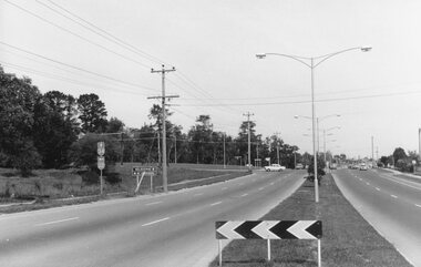 Ringwood and District Historical Society
Photograph, Maroondah Highway East, Ringwood- 1969. Looking west towards Ringwood from Mt Dandenong Road intersection
Black and white photographWritten on back of photograph: "Nov 1969, Cnr Mt Dandenong Road and Maroondah Highway." -
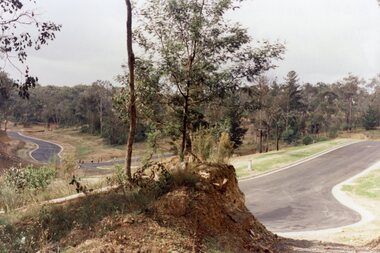 Ringwood and District Historical Society
Photograph, Kubis Estate, North Ringwood in April 1978. View east up Kubis Drive over Jenkin Close and intersection with Werac Drive
E549 N18 Part of a 51-photo record of the development of the "Kubis" Estate, Ringwood North, including road works to Debbie Place, Kubis Drive, Werac Drive, Manuelo Drive, Iluka Place and Glenvale Road. From the Jack Lundy Clarke collection. -
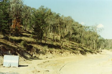 Ringwood and District Historical Society
Photograph, Looking east up the gully over the intersection of Werac and Kubis Drives, North Ringwood, in February 1978
E546 N3 Part of a 51-photo record of the development of the "Kubis" Estate, Ringwood North, including road works to Debbie Place, Kubis Drive, Werac Drive, Manuelo Drive, Iluka Place and Glenvale Road. From the Jack Lundy Clarke collection. -
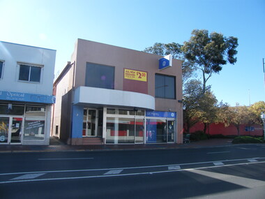
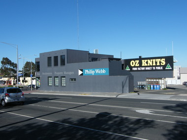 Ringwood and District Historical Society
Photograph, 135 Maroondah Highway, looking south-west across Ringwood Street intersection, in 2008. Showing Philip Webb real estate, formerly the SEC
Photographic record by Russ Haines, RDHS, in 2008. -
 Ringwood and District Historical Society
Photograph, Looking east from 2-6 Ringwood Street, near Maroondah Highway intersection on right, in 2008. Former Post Office was located where the small park is located (on right)
Photographic record by Russ Haines, RDHS, in 2008. -
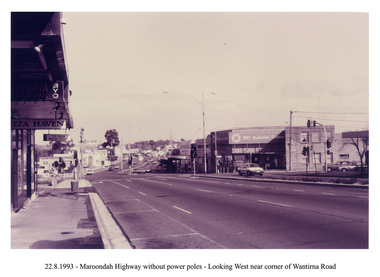 Ringwood and District Historical Society
Photograph, Looking west along Maroondah Highway, Ringwood on 22nd August 1993. Wantirna Road intersection, with SEC building and Ringwood Street on right
-
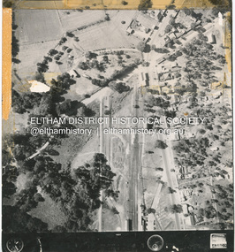
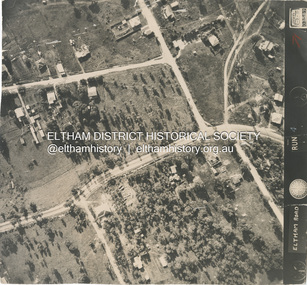 Eltham District Historical Society Inc
Photograph - Aerial Photograph, Main Road, intersection Grand Boulevard and Panorama Avenue, Lower Plenty / Montmorency, 2 Jul. 1951
Not originally catalogued in Shire of Eltham Archives but from the same series of photos taken for Country Road Board study of Main Road wideningshire of eltham archives, aerial photo, country roads board, eltham, main road, road widening, 1951-07, airlie road, ambulance station, beleura grove, grand boulevard, looker road, lower plenty, montmorency, panorama avenue -
 Eltham District Historical Society Inc
Photograph, Peter Pidgeon, Bridge Street intersection with Main Road, Eltham, 2 Aug. 2022
Comparison photo: SEPP_0714 Part of a presentation by Peter Pidgeon to the Society, 13 August 2022 showcasing a series of photographs taken by John Henry Clark over the period 1895 to 1930. John Henry Clark was the youngest of three boys born to William Henry Clark (1823-1877) and Maria White (1843-1914). He and his brothers, William Charles Clark (1872-1945), Clement Kent Clark (1874-1912) operated a photography business (Clark Bros.) from 25 Thomas Street, Windsor near Prahran during the period c.1894 to 1914. Following death of Clement in September 1912 and their mother in 1914, the Clark Bros business appears to have dissolved, the premises demolished, and a new house was under construction in 1915. John set up business independently in 1914 operating out of 29 Moor Street, Fitzroy where he is registered in the 1914 and 1915 Electoral Rolls. By 1916 John had relocated to Eltham where he continued his practice as a photographer and took many of the early images around the district of Little Eltham. Around 1930 John changed professions and opened a small cobbler's shop in 1931 near the pond opposite Dalton Street adjacent to the Jarrold family cottage. He never married and continued his profession as a bootmaker from this little shop, maintaining a close relationship with Mrs Jarrold for the rest of their lives. His bootmaker shop remains today beside the Whitecloud cottage and is one of only three remaining shops in the area from the early 20th century.Comparative photo taken 2022 with one taken from same location over 100 years earlier by noted local photographer J.H. ClarkBorn Digitaleltham, j.h. clark photo (2022), main road, bridge street -
 Eltham District Historical Society Inc
Photograph - Aerial Photograph, Main Road and Anzac Ave intersection, Hurstbridge, 12 Apr. 1954
Victorian Railways Aerial SurveyStamped VR Aerial Survey This print is not rectified Scale Approx 160' to 1 inch Date Photographed 12.4.54 Written Series 33, Item 9shire of eltham archives, aerial photo, main road, anzac avenue, hursbridge, parker road, hurstbridge railway station, rose road -
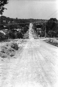
 Eltham District Historical Society Inc
Photograph - Aerial Photograph, Intersection of Main Road and Bridge Street, c.1995
View of Main Road from Henry Street to Brougham Street across to the Diamond Creek showing the Eltham Shire Offices (demolished 1996), the Eltham Library (opened 1994)aerial photo, alistair knox park, bridge street, brougham street, central park, diamond creek (creek), eltham, eltham community centre, eltham courthouse, eltham justice precinct, eltham living and learning, franklin street, henry street, local history centre, main road -
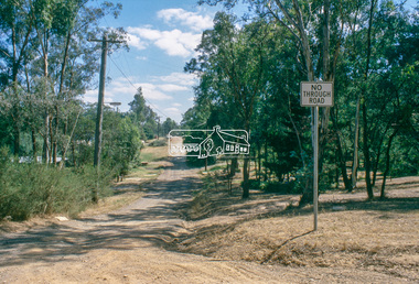 Eltham District Historical Society Inc
Slide, View of Thomas Street from intersection with Frank Street, Eltham, Nov. 1981
Roll of film taken by Eltham Shire Council officers (Nov. 1981) of the Beard street group, a private street scheme, before construction commenced in February 1982. They provide perspective of the changes in housing styles and road development that began sweeping in from the mid 1970s with increasing urbanisation of what was once more outlying suburbs and regions.35 mm colour positive transparency (1 of 27) Mount - Kodak Ektachrome CardProcessed 18 Jan 1982roads, housing estate, infrastructure, private street scheme, eltham, frank street, thomas street -
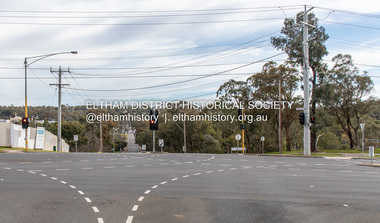
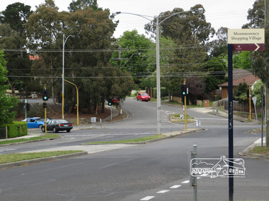 Eltham District Historical Society Inc
Photograph, Liz Pidgeon, Intersection of Grand Boulevard and Panorama Avenue with Main Road, Montmorency, 7 November 2017, 7 Nov 2017
2 born digital imagesgrand boulevard, main road, montmorency, panorama avenue, streets -
 Eltham District Historical Society Inc
Photograph, Looking south towards intersection of York Street near 70 Bible Street, Eltham, c.September 1966, 1966c
Black and white photographic printOriginally located in a Filmpro King Size Prints processing envelope $3.01 Shire of Eltham 9/9/66 and noted as Calrossie Ave area and crossed out Eltham-Yarra Glen Road, Bridge Street to Elsa Court existing conditions mid 1967bible street, road construction, streets, york street -
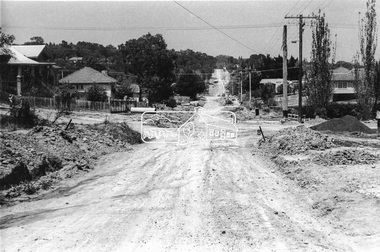 Eltham District Historical Society Inc
Photograph, Looking south along Bible Street towards intersection with Bridge Street, Eltham, c.September 1966, 1966c
Black and white photographic printOriginally located in a Filmpro King Size Prints processing envelope $3.01 Shire of Eltham 9/9/66 and noted as Calrossie Ave area and crossed out Eltham-Yarra Glen Road, Bridge Street to Elsa Court existing conditions mid 1967bible street, bridge street, road construction, streets -
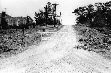 Eltham District Historical Society Inc
Photograph, Looking west along Bridge Street from intersection with Bible Street, Eltham, c.September 1966, 1966c
Black and white photographic printOriginally located in a Filmpro King Size Prints processing envelope $3.01 Shire of Eltham 9/9/66 and noted as Calrossie Ave area and crossed out Eltham-Yarra Glen Road, Bridge Street to Elsa Court existing conditions mid 1967bible street, bridge street, road construction, streets -
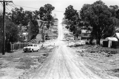 Eltham District Historical Society Inc
Photograph, Looking west along Bridge Street towards intersection with Bible Street, Eltham, c.September 1966, 1966c
Black and white photographic printOriginally located in a Filmpro King Size Prints processing envelope $3.01 Shire of Eltham 9/9/66 and noted as Calrossie Ave area and crossed out Eltham-Yarra Glen Road, Bridge Street to Elsa Court existing conditions mid 1967bible street, bridge street, road construction, streets