Showing 78 items
matching irrigation system
-
 Bendigo Historical Society Inc.
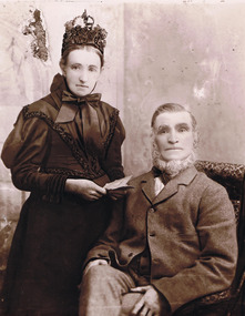
Photograph - Joseph and Margaret Young from Preston Vale (near The Springs) Sedgwick, 1800s-1900s
The Phil Wilkin Collection contains a series of 11 Items. The related items can be found by clicking on the reference link below. The following history of the Young family and their descendants who lived at the Springs is provided by Phil Wilkin. His Great Grandparents were Frances Young and August Wirth. Phil has also provided notes on the Wilkin Family and some history of the gold mining in Sedgwick. Frances Young's parents Joseph and Margaret Young owned the property called "The Old Place, Preston Vale or Wellington Flat" at Sedgwick near the Springs. Joseph Young owned and Managed the Standard Brewery which was located at Campbells Creek during the late 1800’s early 1900’s. Joseph and Margaret are buried in the Harcourt cemetery. In 1880 August Wirth lived at Mosquito Creek (Lake Eppalock, Victoria) when he married Frances Young. In 1902 they moved to part of Joseph Young's property. They milked cows and sold cattle for a living. One of their children Charles Wirth (Phil Wilkin's Grandfather) bought the land in 1935 after his parents had died. Charles Wirth was a councillor and also was president of the Shire of Strathfieldsaye. The "Old Place" was part of the property owned by members of the family. The old house at the Springs was burnt out by bushfire in January 1944 and much of the stonework was later vandalized by campers. The original Coliban Water Works were designed in 1863 by the Irish engineer Joseph Brady. The system included 70 kilometres of open water channels, aqueducts, syphons and tunnels to carry water (by gravity) from the Coliban River at Malmsbury, north to Castlemaine and Bendigo. Sedgwick is a locality in Central Victoria, Australia. It is located in the City of Greater Bendigo. Facilities include a public hall that opened in 1958 and CFA Rural fire station. It was named Upper Emu Creek until 1901 when it was renamed as Sedgwick after British geologist Adam Sedgwick.12 photos and historical document of Joseph and Margaret Young. There are 182 photos in this series and can be found at 8683.1 to 8683.11. The series also includes photos of the surrounding farming land and the remains of an old house. There are also some notes on the pioneers of the district.history, bendigo, coliban water, joseph brady, irrigation, the springs, sedgwick, phil wilkin collection, standard brewery campbells creek, joeseph and margaret young -
 Bendigo Historical Society Inc.
Photograph - The Wilkin Family of Sedgwick, 1800s-1900s
The Phil Wilkin Collection contains a series of 11 Items. The related items can be found by clicking on the reference link below. The following history of the Young family and their descendants who lived at the Springs is provided by Phil Wilkin. His Great Grandparents were Frances Young and August Wirth. Phil has also provided notes on the Wilkin Family and some history of the gold mining in Sedgwick. Frances Young's parents Joseph and Margaret Young owned the property called "The Old Place, Preston Vale or Wellington Flat" at Sedgwick near the Springs. Joseph Young owned and Managed the Standard Brewery which was located at Campbells Creek during the late 1800’s early 1900’s. Joseph and Margaret are buried in the Harcourt cemetery. In 1880 August Wirth lived at Mosquito Creek (Lake Eppalock, Victoria) when he married Frances Young. In 1902 they moved to part of Joseph Young's property. They milked cows and sold cattle for a living. One of their children Charles Wirth (Phil Wilkin's Grandfather) bought the land in 1935 after his parents had died. Charles Wirth was a councillor and also was president of the Shire of Strathfieldsaye. The "Old Place" was part of the property owned by members of the family. The old house at the Springs was burnt out by bushfire in January 1944 and much of the stonework was later vandalized by campers. The original Coliban Water Works were designed in 1863 by the Irish engineer Joseph Brady. The system included 70 kilometres of open water channels, aqueducts, syphons and tunnels to carry water (by gravity) from the Coliban River at Malmsbury, north to Castlemaine and Bendigo. Sedgwick is a locality in Central Victoria, Australia. It is located in the City of Greater Bendigo. Facilities include a public hall that opened in 1958 and CFA Rural fire station. It was named Upper Emu Creek until 1901 when it was renamed as Sedgwick after British geologist Adam Sedgwick.17 photos and historical document of the Wilkin Family associated with the Springs near Sedgwick. There are 182 photos in this series and can be found at 8683.1 to 8683.11. The series also includes photos of the surrounding farming land and the remains of an old house. There are also some notes on the pioneers of the district.history, bendigo, coliban water, joseph brady, irrigation, the springs, sedgwick, phil wilkin collection, standard brewery campbells creek, joeseph and margaret young, wilkin family -
 Bendigo Historical Society Inc.
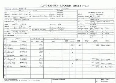
Photograph - The Wilkin Family of Sedgwick - Isaac and Letitia Barcley, 1800s-1900s
The Phil Wilkin Collection contains a series of 11 Items. The related items can be found by clicking on the reference link below. The following history of the Young family and their descendants who lived at the Springs is provided by Phil Wilkin. His Great Grandparents were Frances Young and August Wirth. Phil has also provided notes on the Wilkin Family and some history of the gold mining in Sedgwick. Frances Young's parents Joseph and Margaret Young owned the property called "The Old Place, Preston Vale or Wellington Flat" at Sedgwick near the Springs. Joseph Young owned and Managed the Standard Brewery which was located at Campbells Creek during the late 1800’s early 1900’s. Joseph and Margaret are buried in the Harcourt cemetery. In 1880 August Wirth lived at Mosquito Creek (Lake Eppalock, Victoria) when he married Frances Young. In 1902 they moved to part of Joseph Young's property. They milked cows and sold cattle for a living. One of their children Charles Wirth (Phil Wilkin's Grandfather) bought the land in 1935 after his parents had died. Charles Wirth was a councillor and also was president of the Shire of Strathfieldsaye. The "Old Place" was part of the property owned by members of the family. The old house at the Springs was burnt out by bushfire in January 1944 and much of the stonework was later vandalized by campers. The original Coliban Water Works were designed in 1863 by the Irish engineer Joseph Brady. The system included 70 kilometres of open water channels, aqueducts, syphons and tunnels to carry water (by gravity) from the Coliban River at Malmsbury, north to Castlemaine and Bendigo. Sedgwick is a locality in Central Victoria, Australia. It is located in the City of Greater Bendigo. Facilities include a public hall that opened in 1958 and CFA Rural fire station. It was named Upper Emu Creek until 1901 when it was renamed as Sedgwick after British geologist Adam Sedgwick.Seven historical documents of Isacc and Letitia Barcley who were associated with the Wilkin Family and also with the Springs near Sedgwick. There are 182 photos in this series and can be found at 8683.1 to 8683.11. The series also includes photos of the surrounding farming land and the remains of an old house. There are also some notes on the pioneers of the district.history, bendigo, coliban water, joseph brady, irrigation, the springs, sedgwick, phil wilkin collection, joeseph and margaret young, letitia and isacc barclay -
 Tatura Irrigation & Wartime Camps Museum
Booklet, Edmund D Gill, Rivers of History, 1970
A series of 10 ABC radio talks originally broadcast under the title "The Murray Darling System, 5000 Miles of history and prehistory. The series was produced in the Melbourne studios of the ABC by Ken TaylorBeige cover. Australian river scene on front cover. Information on the work of the author Edmund T. Gill on back cover.river systems -
Tatura Irrigation & Wartime Camps Museum
Booklet, Joyce Hammond et al, Waranga Basin History, 1989 reprint
Include details of contruction of Waranga SystemWritten by Joyce Hammond giving historical information from Aboriginal presence to the situation in 1977 with reference to members of Gunn and Hammond Families.waranga basin -
Tatura Irrigation & Wartime Camps Museum
Book, Lehr - Und U Bunksbuch Fur Anfanger (teaching - and exercise book for beginners), 22 October 1944
Exercise and practice book for the beginner. 10 Finger system. Typing used by students at Dhurringile camp.Hard cloth buff coloured covered folder of loose leaf paper pages, hand typedlehr - und u bunksbuch fur anfanger, camp 1 education, camp 1 typing lessons, dhurringile education classes, stefan eberhard, typing, dhurringile camp, internee typing class -
Tatura Irrigation & Wartime Camps Museum
Report, Systems and the New Role of the Water Industry Services Division, 1980s
Typed reports about water management in Victoriairrigation -
Tatura Irrigation & Wartime Camps Museum
Sewing Machine, 19th Century
This sewing machine, made in Germany in the 19th Century, was used extensively in Tatura Camp 3. Its owner; Mrs Elisabeth Hoffmann, was permitted to bring it with her from Palestine on condition that she would make it available to everyone who wanted to use it. There was a roster system and the machine was in constant use for five years. Because normal dress material was scarce, the internees made clothes out of some of the grey army blankets and burgundy overcoats issued to them. The coats were boiled to remove the burgundy dye, then re-dyed green, navy or black, and converted into various items of clothing. The sewing machine coped well with this heavy use. After release from the camp in 1946, Mrs. Hoffmann continued to use it until 1972.Hand operated, table top model sewing machine, with decorative pattern and lettering in gold, hinged to wooden caseGM Pfaff, Kaiserlauternsewing machine, pfaff, polacsek e, uhlherr h, camp 3, tatura, domestic, sewing -
Tatura Irrigation & Wartime Camps Museum
Booklet, History of the Waranga Basin, 1989 (reprint)
... system irrigation boat club books history local Buff soft covered ...Includes details of construction of Waranga systemBuff soft covered book with map of Waranga Basin and text in brown Written by Joyce Hammond giving historical information from aboriginal presence to the situation in 1977 with reference to members of the Gunn and Hammond familiesirrigation, boat club, books, history, local -
Tatura Irrigation & Wartime Camps Museum
Booklet, Farm Chanels for Border Check Irrigation, 1991
Explaining farm channel system. Includes information on Dethridge MeterCream cover, black writing, blue logo of Rural Water Commission of Victoria on front and channel sceneirrigation, books, history, local, rural, industry -
Tatura Irrigation & Wartime Camps Museum
Program, Goulburn Weir Rehabilitation Works Opening Ceremony
... names of Victoria, map, Goulburn River system irrigation ...Includes weir construction history, aboriginal names of Victoria, map, Goulburn River systemProgram of Opening Ceremony. White paper, black writing, blue water wheel logo in plastic sleeveirrigation, document, program, rural, industry -
Tatura Irrigation & Wartime Camps Museum
Shield - Sports, Tatura & District School Sports Assn, 1973
T.D.S.S.A. commenced in 1945 with all local and district primary schools competing for the LaPeyre Shield. In 1973 the Assn. was split so that smaller rural schools competed for the Tatura Milk Products Shield. After 1976 the competition for shields changed to a system not competing for shields.Heart shaped wooden backing with silver shield in centre. Small shields surround central one with name of winning school and year engraved. Silver ribbon above with T.D.S.S.A. engraved.T.D.S.S.A. (Tatura and District School Sports Assn) divisional shield present by Tatura Milk Productst.d.s.s.a. -
Tatura Irrigation & Wartime Camps Museum
Booklet, History of the Waranga Basin, 1989 (reprint)
... system irrigation boat club books history local Buff soft covered ...Includes details of construction of Waranga systemBuff soft covered book with map of Waranga Basin and text in brown Written by Joyce Hammond giving historical information from aboriginal presence to the situation in 1977 with reference to members of the Gunn and Hammond familiesirrigation, boat club, books, history, local -
Tatura Irrigation & Wartime Camps Museum
Book, The Goulburn Weir, 1893
... to production the goulburn weir irrigation dependant systems tatura ...Giving information re engineering undertaken during construction of weir, plus cross sections of work related to productionCard covered with marbled paper. Leather spine. Title as a label in centre positionSM Hawkins esq. per M Nally. 21.5.1896the goulburn weir, irrigation, dependant systems, tatura, books, history, local -
University of Melbourne, Burnley Campus Archives
Book - PhD Thesis, Christie Kar-Ming Ho, Profitable Irrigateds Dairy Farming Systems: Exploring Efficiencies in Feeding Systems with Decreasing Water Availability, 2010
... thesis Profitable Irrigateds Dairy Farming Systems: Exploring ...agricultural science, dairy, phd thesis -
 Bacchus Marsh & District Historical Society
Map, Plan of part of the road district of Bacchus Marsh circa 1856-1862
... and 1862. The main purpose of this map was to shown the irrigable ...Local government in much of Victoria including the Bacchus Marsh area began with the formation of 'local committees'. These local committees could make representations to a Central Road Board regarding plans for road construction. Road construction and maintenance were seen as the essential tasks of these early local government authorities. By 1856 the local committee in Bacchus Marsh was constituted as the Bacchus Marsh Road District. This entity continued until 1862 when the name changed to the Bacchus Marsh and Maddingley Road District. This new entity lasted until 1871 when the local government authority in accordance with new statewide legislation became known as the Shire of Bacchus Marsh. The title of this plan being a plan of 'a portion of the road district of Bacchus Marsh' suggests that the plan was produced sometime between 1856 and 1862. The main purpose of this map was to shown the irrigable land in the district and the sources from which water for irrigation could be drawn. Bacchus Marsh was an early irrigation district in Victoria. Irrigation trusts were formed in the 1880s and 1890s to manage irrigation districts. But this was the culmination of many years of earlier attempts to construct irrigation systems in the Bacchus Marsh area and create a system to manage irrigation more broadly. This map dating from around 1856-1862 is an important cartographic document which provides evidence of how the early planning for irrigation was developing in the Bacchus Marsh region.A single page paper map showing a plan of part of the road district of Bacchus Marsh. The map is pasted into a bound volume containing 76 maps or plans in total. High resolution digital image stored on BMDHS computer network. bacchus marsh victoria maps, bacchus marsh road district, local government, road districts, irrigation -
Merbein District Historical Society
Map, Merbein Irrigation District Drainage Systems, 5 Dec.1936
... Drainage Irrigation Merbein Irrigation District Drainage Systems ...drainage, irrigation -
University of Melbourne, Burnley Campus Archives
Plan, Como, 1983, 1993
... and placement. (2) 2 copies Blueprint - Automatic Watering System Legend... Blueprint - Automatic Watering System Legend by Planned Irrigation ...(1) Como Plant Inventory: Rear of House - Big Pond Lawn, Fountain Terrace and The Paddock dated November 1983, Landform Australia - photocopy in 2 sheets. Numbered list of plants and placement. (2) 2 copies Blueprint - Automatic Watering System Legend by Planned Irrigation Projects Pty. Ltd. (3) Tracing paper and paper plans of Croquet Lawn and Pony Paddock 'Como', Como Avenue, South Yarra - Landscape Studies Assignment 1993.como house, plant inventory, south yarra, irrigation