Showing 599 items matching "lookouts"
-
 Ballarat Heritage Services
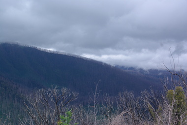
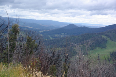
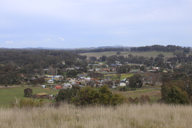
Photograph - Colour, Clare Gervasoni, Marysville after 'Black Saturday' from Nicholl Lookout , 2012, 16/12/2012
Colour photograph of the Marysville locality from Nicholl Lookoutbushfire, black saturday, marysville, nicholl lookout -
 Ballarat Heritage Services
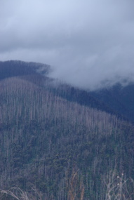
Photograph - Photograph - Colour, Clare Gervasoni, Marysville after 'Black Saturday' from Nicholl Lookout , 2012, 16/12/2012
Colour photograph of the Marysville locality from Nicholl Lookoutbushfire, black saturday, marysville, nicholl lookout -
 Ballarat Heritage Services
Photograph - Colour, Clare Gervasoni, Marysville after 'Black Saturday' from Nicholl Lookout , 2012, 16/12/2012
Colour photograph of the Marysville locality from Nicholl Lookoutbushfire, black saturday, marysville, nicholl lookout -
 Ballarat Heritage Services
Photograph - Colour, Clare Gervasoni, Marysville after 'Black Saturday' from Nicholl Lookout , 2012, 16/12/2012
Colour photograph of the Marysville locality from Nicholl Lookoutbushfire, black saturday, marysville, nicholl lookout -
 Ballarat Heritage Services
Photograph - Colour, Clare Gervasoni, Marysville after 'Black Saturday' from Nicholl Lookout , 2012, 16/12/2012
Colour photograph of the Marysville locality from Nicholl Lookoutbushfire, black saturday, marysville, nicholl lookout -
 Ballarat Heritage Services
Photograph - Colour, Clare Gervasoni, Marysville after 'Black Saturday' from Nicholl Lookout , 2012, 16/12/2012
Colour photograph of the Marysville locality from Nicholl Lookoutbushfire, black saturday, marysville, nicholl lookout -
 Ballarat Heritage Services
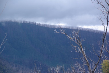
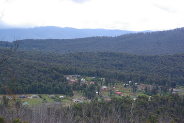
Photograph - Colour, Clare Gervasoni, Marysville from Nicholl Lookout after 'Black Saturday', 2012, 16/12/2012
Colour photograph of the Marysville locality from Nicholl Lookoutbushfire, black saturday, marysville, nicholl lookout -
 Ballarat Heritage Services
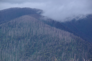
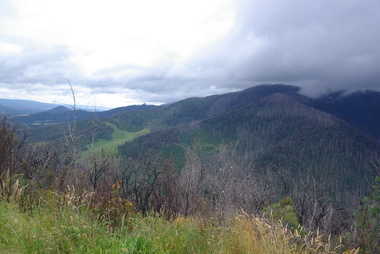
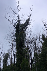
Photograph - Colour, Clare Gervasoni, Tree regrowth after 'Black Saturday' from Nicholl Lookout , 2012, 16/12/2012
Colour photograph of the Marysville locality from Nicholl Lookoutbushfire, black saturday, marysville, nicholl lookout -
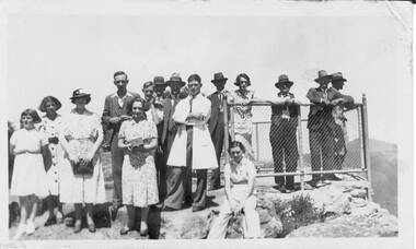 Halls Gap & Grampians Historical Society
Photograph - B/W, c 10930-40s
Group would have been typical of tourist parties of the day, Such groups stayed at and were catered by local guesthouses offering walking activities with guides.photo shows a group of people (5 women,1 girl,9 men) standing on rocky platform and lookout. A wire fence surrounds edge of lookout on three sides.people, tourists -
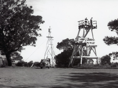 Lakes Entrance Historical Society
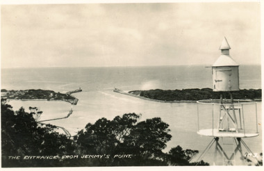
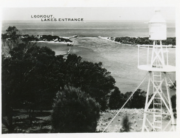
Photograph - Lookout tower Jemmy's Point, 1960
Also one other photograh similar showing steps, landing, and Carpenters Chev car parked.Black and white photograph of the timber lookout on Jemmys Point, steel tower with signal light in background, base of old lookout tree visible on left of image. Lakes Entrance, Victoria.historic sites, navigation -
 Glenelg Shire Council Cultural Collection
Photograph, n.d
Sourced from Casterton Town Hall (Former Shire of Glenelg)Black and white photograph. View of Casterton from Mickle Lookout -
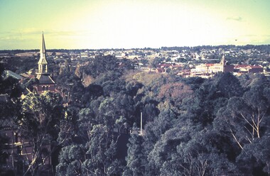 Bendigo Historical Society Inc.
Slide - BENDIGO & EASTER FAIR, c1966
View of Bendigo from the lookout tower in Rosalind Park, Bendigo.slide, bendigo, view of bendigo, tower rosalind park view of bending -
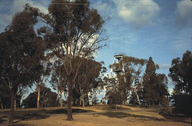 Bendigo Historical Society Inc.
Slide - BENDIGO VIEWS, May 1964
Slide. Bendigo Views. Lookout Tower and trees in Rosalind Park.slide, bendigo, bendigo views, bendigo views -
 Bendigo Historical Society Inc.
Slide - BENDIGO VIEWS, Feb 1963
Slide. Bendigo Views. View of the Lookout Tower in Rosalind Park.slide, bendigo, bendigo views, bendigo views -
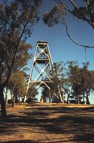
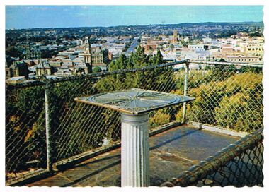
 Ballarat Heritage Services
Photograph - Photograph - Colour, L.J. Gervasoni, Guildford from the Lookout, 2017, 17/07/2017
Photographic views from the Alfred Passalaqua Memorial Lookout at Guildford.guildford, volcano, alfred passalaqua -
Federation University Bookplate Collection
Work on paper - Bookpplate, Regina Lituaniae -100 Ex Libris
After a quiet period, interest in bookplates in Australia began to increase in the early 1970s, Entrepreneurial art and book collectors such as Edwin Jewell and others commissioned multiple Bookplate designs from a range of well known fine artists. At a 1997 meeting in Melbourne of the Ephemera Society of Australia Edwin Jewell and others announced the formation of the Australian Bookplate Society. The society was instrumental in promoting the art of the bookplate through establishment of the Australian Bookplate Design competition. The competition includes a design award for International bookplate designers and graphic artists. as well as Australian secondary school students. Lookout tower with centenary numeral and three flags & birds flying.17/34-"Trakai History Museum 2018 - Signaturebookplate, australian bookplate design awards, kieth wingrove trust, ex libris, lithuania -
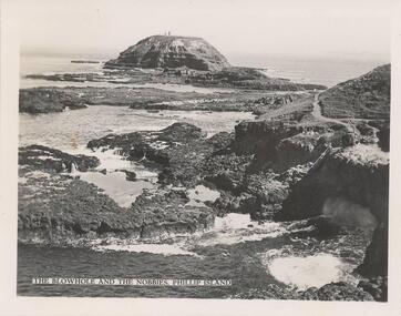 Phillip Island and District Historical Society Inc.
Photograph, 1940's - 1950's
One of a collection of 9 photographs donated by the former Shire of Phillip Island. One of a series of photographs sold as a pack of postcards for tourists/visitors to Phillip Island.Black & White photograph - view of Blowhole and The Nobbies from the lookout at The Nobbies."The Blowhole and The Nobbies. Phillip Island"blowhole, the nobbies blowhole phillip island, rock formations, phillip island coastline, shire of phillip island -
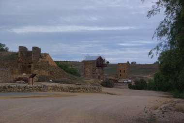 Victorian Interpretive Projects Inc.
Photograph - Colour, Clare Gervasoni, View from Burra Lookout, South Australia, 29/05/2013
Burra is a town in South Australia's Copper triangle. View of mining remnants at Burra, South Australia from the Burra Lookout. -
 Rutherglen Historical Society
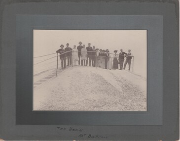
Image, c1915
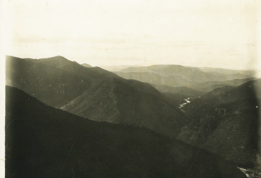
Black and white photograph, mounted on cardboard, of a group of people posing at a lookout. Written at bottom of mount: "The Horn, Mt Buffalo"the horn, mt buffalo, victorian alps, great dividing range, mount buffalo -
 Falls Creek Historical Society
Photograph - Timms Lookout, Bogong High Plains
MEYER COLLECTION - FALLS CREEK PHOTOS In 1947 a determined group of like-minded State Electricity Commission (SEC) staff including Ray Meyer, the chief surveyor of the Kiewa Hydro-Electric Scheme, had a common interest that revolved around the skiing potential of the snow-covered high plains which included what is now the resort of Falls Creek. The six SEC employees, Toni St Elmo, Ray Meyer, Jack Minogue, Lloyd Dunn, Adrian Ruffenacht and Dave Gibson (together with their families) banded together to secretly build a 'hut' that was the first ski lodge at Falls Creek. Using a road built in 1930s to gain access to Falls Creek, their hut project was carried out in secret as efforts by other skiers were blocked by H.H.C. Williams – the engineer in charge of the Hydro Scheme. In 1946 Ray Meyer made a trip to the Lands Office in Melbourne. He came away with a 99-year lease on three acres that was ideally suited for a hut designed by Lloyd Dunn. Adrian Ruffenacht (Design Engineer for the KHS) had suggested where the group should build because of easy access to a spring for water. Much of the building material required was scavenged from derelict huts on the high plains. Due to the need for secrecy, the determined group worked on the hut in the evenings and weekends to avoid detection. During the building period the group had met at Echidna Rock (now known as Eagle Rock) where Skippy St Elmo announced, "This is my favourite ‘Skyline’.” And so the first lodge in the area at Falls Creek Ski Resort came into existence. With the development of the International Poma in the 1970s, the Skyline Lodge, which was sited between the ski-lift’s pole one and pole two, was demolished. However, the legacy of Ray Meyer, Toni St Elmo, Jack Minogue, Lloyd Dunn, Adrian Ruffenacht and Dave Gibson and Skyline lives on in the vibrant atmosphere of Falls Creek Resort. The MEYER COLLECTION documents developments on the Kiewa Hydro Scheme and their life at Falls Creek from the mid 1930s to 1960s.This image is significant because it depicts aspects of the life of a pioneering family of Falls Creek and the founders of "Skyline", the first lodge at Falls Creek.Two black and white images a Timms Lookout taken prior to WWII.falls creek, bogong high plains, timms lookout -
 Lakes Entrance Historical Society
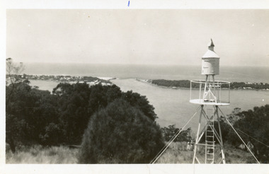
Photograph - Jemmys Point, 1950c
Black and white photograph of the entrance, taken from lookout on Jemmys PointThe Entrance from Jemmy's Pointwaterways, ocean, navigation -
 Lakes Entrance Historical Society
Photograph - The Entrance, 1950c
Black and white photograph of the entrance, taken from lookout on Jemmys Pointwaterways, dredging, ocean -
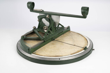
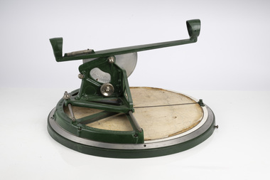 Department of Energy, Environment and Climate Action
Fire Finder
Victoria once had well over one hundred fire lookouts and firetowers. Fire lookouts, or observation posts, were often just a clearing on a hill or a vantage point, whereas firetowers were definite structures. Many were established by the Forests Commission Victoria (FCV) in the 1920s, but the network was expanded rapidly in response to recommendations of the Stretton Royal Commission after the 1939 Black Friday bushfires. When a fire or smoke was spotted from the tower a bearing was taken with the alidade and radioed or telephoned into the district office. It was then cross referenced with bearings from other towers on a large wall map to give a "fix" on the fire location. Alidades and telescopes were used in the post war period but were replaced with a much simpler map table and reference string suspended from the centre of the tower cabin. This "Fire Finder" was used in Canadian fire towers to identify the location of wildfires. The unique design was first developed by the British Columbia Forest Service (BCFS) in the early 1950s. Close examination of the map indicates that this particular Fire Finder may have been once used at Bluejoint Mountain lookout in Granby Provincial Park. This Fire Finder was a gift to Barry (Rocky) Marsden from the British Columbia Forest Service in the late 1980s in recognition of the close relationships that had been forged with the staff at the Altona Workshops over many decades. Fire Finders were originally painted black but this one was repainted green after it arrived at Altona. The BC Forest Service had a large facility where they manufactured Fire Finders and many other items of equipment, but in the 1980s it was shut down. Heavy cast iron circular object with a paper topographic map mounted on it. The metal dial and ruler works similar to a compass. The sight tube is used to determine the bearing and elevation of the fire on the map. This Fire Finder also sometimes known as an Alidade. Its a different design from the Osborne Fire Finder widely used in North American fire lookouts from the 1920s. British Columbia Forest Service. Model 62A. Serial Number 6308.bushfire -
 Bendigo Historical Society Inc.
Postcard - LOOKOUT TOWER, ROSALIND PARK
Postcard: image shows landscape view of Bendigo, taken from Lookout Tower, Rosalind Park. On back ' Bendigo, Victoria, panormama of Bendigo from Rosalind Park Lookout Tower' Nu Color Vue, BE 39.Nu Color Vue BE39, Copyrightbendigo, hospital, bendigo, rosalind park, lookout tower -
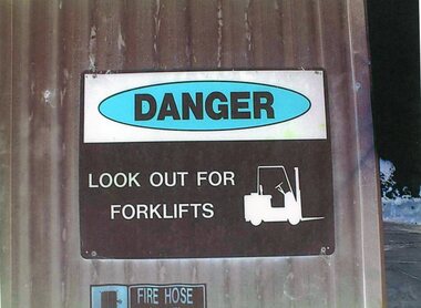 Stawell Historical Society Inc
Photograph - Aunde Album 29, Safety Signs, 2002
Aunde / Norwellan Textiles North Western Woolen Mills became Norwellan Textiles then AUNDEColour landscape photo: Corrugated sliding door with safety signs. Warehouse door1- Danger Lookout for Forklift 2 - Fire hose and reelindustry, aunde -
 Lakes Entrance Historical Society
Photograph - Snowy River at Glenantipy, Rev John Flynn, 1906 c
Photographic proof on light cardBlack and white photograph of view of Snowy River from the lookout at Gelantipy Victoriatopography, waterways -
 Bendigo Historical Society Inc.
Photograph - BENDIGO PHOTO FOLDER
Gray covered photo folder, includes photos of Rosalind Park, Lake Weeroona boatsheds, conservatory, Pall Mall, Queens Gardens, lookout poppet head, panorama frog m lookout tower, Bendigo.Early 1900'splace, bendigo, view of bendigo -
 Bendigo Historical Society Inc.
Slide - Images by Arthur Pulfer, About 1957-1970
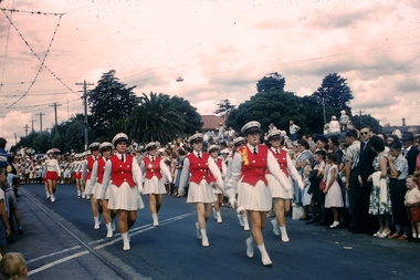
Many images from by Arthur Pulfer copied to slides. Fifteen Slides of the Bendigo Easter parade, includes the Bendigo Show, Rosalind Park Sound Shell and lookout; One Tree Hill Lookout and Williamson Street Toilet Block.history, bendigo, james lerk collection, bendigo easter parade, bendigo conservatory, one tree hill lookout, marching girls bendigo, brass bands bendigo, bendigo rosalind park -
 Lakes Entrance Historical Society
Photograph - The Entrance, 1950c
Also postcard 7 x 10.5, similar image,Black and white photograph of the entrance, taken from lookout on Jemmys Point, shows signal light adjacent to lookout, people on slope in front of signal, New Works cottages on hummocks, ocean horizon in distance. Lakes Entrance VictoriaThe Entrance from Jemmy's Pointwaterways, ocean, navigation