Showing 78 items
matching lower plenty, main road, old eltham road
-
 Eltham District Historical Society Inc
Slide - Photograph, Ingrams Road, Research, c.Aug. 1990
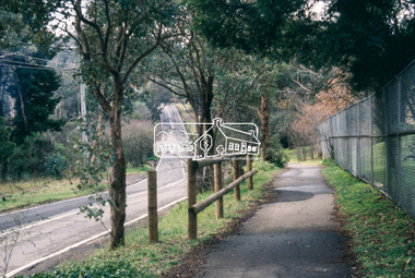
Part of a presentation, "Roads and Byways of the Shire of Eltham", by Russell Yeoman to the 12 September 1990 Society meeting. Slides shown included copies of old photos and recent images ranging from the suburban streets of Eltham and Montmorency to the mountain roads of Kinglake. In the byways category are views of some iof the Shire's bicycle paths including then recently completed sections of the Main Yarra Trail at Lower Plenty.35mm colour positive transparency (1 of 37) Mount - Agfachrome Agfa CS System black 8 dotsinfrastructure, roads, ingrams road, research (vic.), research preschool -
 Eltham District Historical Society Inc
Slide - Photograph, Eltham-Yarra Glen Road, Research, c.Aug. 1990
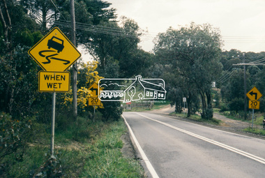
Part of a presentation, "Roads and Byways of the Shire of Eltham", by Russell Yeoman to the 12 September 1990 Society meeting. Slides shown included copies of old photos and recent images ranging from the suburban streets of Eltham and Montmorency to the mountain roads of Kinglake. In the byways category are views of some iof the Shire's bicycle paths including then recently completed sections of the Main Yarra Trail at Lower Plenty.35mm colour positive transparency (1 of 37) Mount - Agfachrome Agfa CS System black 8 dotsinfrastructure, roads, research (vic.), cassells road, eltham-yarra glen road -
 Eltham District Historical Society Inc
Slide - Photograph, Eltham-Yarra Glen Road, Research, c.Aug. 1990
Part of a presentation, "Roads and Byways of the Shire of Eltham", by Russell Yeoman to the 12 September 1990 Society meeting. Slides shown included copies of old photos and recent images ranging from the suburban streets of Eltham and Montmorency to the mountain roads of Kinglake. In the byways category are views of some iof the Shire's bicycle paths including then recently completed sections of the Main Yarra Trail at Lower Plenty.35mm colour positive transparency (1 of 37) Mount - Agfachrome Agfa CS System black 8 dotsinfrastructure, roads, research (vic.), eltham-yarra glen road -
 Eltham District Historical Society Inc
Slide - Photograph, Catherine Court, Eltham, c.Aug. 1990
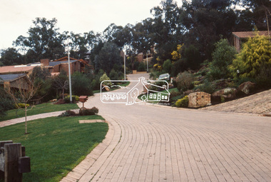
Part of a presentation, "Roads and Byways of the Shire of Eltham", by Russell Yeoman to the 12 September 1990 Society meeting. Slides shown included copies of old photos and recent images ranging from the suburban streets of Eltham and Montmorency to the mountain roads of Kinglake. In the byways category are views of some iof the Shire's bicycle paths including then recently completed sections of the Main Yarra Trail at Lower Plenty.35mm colour positive transparency (1 of 37) Mount - Agfachrome Agfa CS System black 8 dotsinfrastructure, roads, catherine court, eltham -
 Eltham District Historical Society Inc
Slide - Photograph, Catherine Court, Eltham, c.Aug. 1990
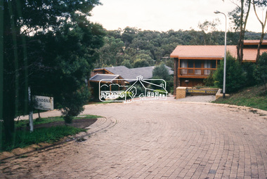
Part of a presentation, "Roads and Byways of the Shire of Eltham", by Russell Yeoman to the 12 September 1990 Society meeting. Slides shown included copies of old photos and recent images ranging from the suburban streets of Eltham and Montmorency to the mountain roads of Kinglake. In the byways category are views of some iof the Shire's bicycle paths including then recently completed sections of the Main Yarra Trail at Lower Plenty.35mm colour positive transparency (1 of 37) Mount - Agfachrome Agfa CS System black 8 dotsinfrastructure, roads, catherine court, eltham -
 Eltham District Historical Society Inc
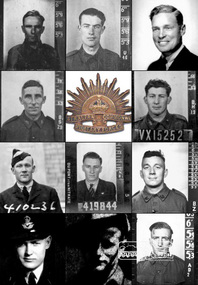
Document (Item) - Article, The Eltham Roll of Honour: Second World War, 9 Aug 2020
Information regarding the circumstances of the eleven men of the Shire of Eltham who died serving their country in the Second World War and for whom the Eltham War Memorial was dedicated. Their names are listed on the Eltham Roll of Honour in order of rank. The image portrayed shows the eleven men (left to right, top to bottom) by date of fatality: CASTLEDINE, George Ernest, Spr., VX10044 (KIA 18 Apr 1941, Greece) GAHAN, Studley Manston, Capt., VX48379 (KIA 17 May 1941, Tobruk, Libya) RUTTER, David, Flying Off., 833 (400833) (KIA 9 Dec 1941, Bir El Gubbi, Libya) CLERKE, Alfred Charles, Cpl., VX23112 (KIA 2 Feb 1942, Laha, Ambon Island) DUNLOP, Cuthbert Douglas, Sgt., VX15252 (KIA 22 Nov 1942, Gona, New Guinea) INGRAM, Lester Neil, Flt. Sgt., 410236 (DOD 22 Apr 1943, Longworth, England) McLEAN, Stanley, Flt. Sgt., 419844 (KIA 7 Oct 1944, Emmerich, Germany) FELDBAUER, Theodore, Sgt., VX51733 (DOD 27 Mar 1945, Borneo) RUTTER, Donald Hemphill, Flt. Lt., 410262 (KIA 5 Apr 1945, Varrelbusch, Germany) FIELD, Kevin Francis, Pte., VX144763 (KIA 28 Jun 1945, Bougainville, PNG) BUTHERWAY, Jack Herbert, Pte, VX37645 (DOD 8 Jul 1945, Borneo)eltham war memorial, roll of honour, second world war, eltham, eltham roll of honour, shire of eltham, 2/4 field workshop, 22 independent brigade group ordnance workshop, a.i.f., australian army ordnance corps, australian corps of electrical and mechanical engineers, changi, falkiner street, florence mary butherway, jack herbert butherway, prisoner of war (pow), ranau number 1 jungle camp, sandakan death march, singapore, thomas james butherway, vx37645, 2/2 field company, 6th division, abington, annie castledine, arthur frederick castledine, george ernest castledine, greece, jean simonson, lower plenty, old eltham road, royal australian engineers, vx10044 sapper g. e. castledine, 2/23 bn, derril, gahan house, main road, rats of tobruk, studley manston gahan, tobruk, vx48379, 3 squadron r.a.a.f., aboukir, alamein memorial, beulah alice (simpson) rutter, bir el gubbi, broken hill aero club, david rutter, egypt, hubert rutter, libya, yarra braes, 2/21 bn, 23rd australian infrantry brigade, 8th division, alfred charles clerke, ambon island, battle of ambon, bidgeland park estate, inga caroline (nicholls) clerke, inga mary nicholls, laha airfield, nora ann clerke, rose matilda clerke, vx23112, william charles clerke, 2/14 bn, 2/16 bn, 21st brigade, 7th division, cuthbert douglas dunlop, gona, gona war cemetery, henry street, janet dunlop, kokoda track, new guinea, palestine, papua new guinea, port moresby (bomana) war cemetery, reuben cuthbert dunlop, syria, vx15252, 10 operational training unit, 410236, ada (key) ingram, berkshire, bomber command, england, group no. 91, john ingram, lester neil ingram, longworth, n.1374, r.a.a.f., r.a.f., r.a.f. abington, research (vic.), whitley v bomber, 419844, 514 bomber squadron, emmerich, germany, gordon stanley mclean, ji-g2, kleve, lancaster lm735, lucy mclean, mount pleasant road, r.a.f. waterbeach, reichswald forest war cemetery, stanley mclean, 2/10 ordnance workshops, albert feldbauer, eltham cricket association, eltham girls club, frank street, henry feldbauer, jessie margarette feldbauer, june feldbauer, ken ingram, margaret (feldbauer) ingram, montmorency imperials, research cricket club, research state school, sandakan number 1 camp, sandakan number 2 camp, theodore albert feldbauer, valerie (feldbauer) waller, violet amelda (teagle) feldbauer, vx51733, 247 ‘china-british’ squadron, caithness, cloppenburg, donlad hemphill rutter, essen, gloucester, hanover war cemetery, hanover-limmer british military cemetery, holten-lochem, oldenburg, r.a.f. castletown, r.a.f. station lealing, stoppenburg, typhoon ib jp443, typhoon ib sw526, 15th australian infantry brigade, 1940 cup, 3rd division, 57th/60th bn, best and fairest, bougainville island, buin road, mary field, mayona road, mivo river, mobiai river, montmorency, vx144763, william field -
 Eltham District Historical Society Inc
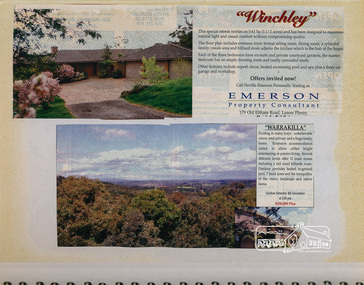
Newsclipping, Winchley, 179 Old Eltham Road, Lower Plenty and Warrakilla
Contained in Volume 1 of a set of two spiral magnetic photo albums, each containing 10 leaves, 20 pages; Vol. 1 labelled "Houses - Eltham South" and Vol. 2 labelled "Eltham Houses". Newspaper clippings advertising house auctionseltham, eltham south, real estate advertisement, houses, neville emerson real estate, old eltham road, warrakilla, winchley -
 Greensborough Historical Society
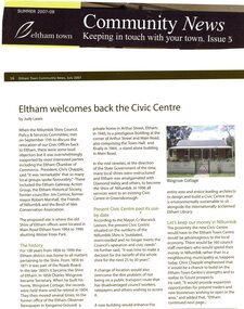
Magazine - Article, Judy Lewis, Eltham welcomes back the Civic Centre, by Judy Lewis, 2008
Article on proposal to move the Nillumbik Shire Council Offices to the site of the old Shire of Eltham offices on Main Road Eltham, adjacent to the Eltham Library2 p., text, black and white and colour photographs. Extract from Eltham Town Community News, Issue 5, Summer 2007-08nillumbik council, eltham, main road eltham -
 Greensborough Historical Society
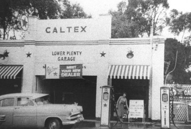
Photograph - Digital Image, Lower Plenty Garage, 1950s
... Lower Plenty Garage (a Caltex service station) on Main Road... service station) on Main Road Lower Plenty (previously Old Eltham ...Lower Plenty Garage (a Caltex service station) on Main Road Lower Plenty (previously Old Eltham Road) in the 1950s. This photograph shows the garage with petrol pumps out front and a Caltex sign above door.Digital copy of black and white photographlower plenty, lower plenty garage, main road lower plenty, old eltham road lower plenty, caltex garage lower plenty -
 Greensborough Historical Society
Photograph - Digital image, John Blackbourn, 1939_
John Blackbourn, born 1936; taken at corner of Old Eltham Road and Main Street. Photographs from the collection of Peter Blackbourn, a descendant of the Chapman Stock family. Annotations to photos by Peter Blackbourn.Digital copy of black and white photograph.peter blackbourn, john blackbourn -
 Greensborough Historical Society
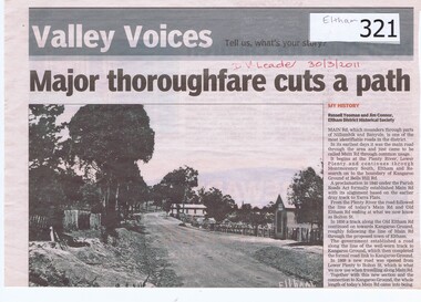
Newspaper clipping, Major Thoroughfare Cuts a Path, 30/3/2011
A half page newspaper article with a photograph of an early Eltham scene recording the origins of Main Road, Eltham. Written by Eltham District Historical Society members Russell Yeoman and Jim Connor.Details some of the deviations that Main Road had taken during its earliest years.A half page newspaper article with a photograph of an early Eltham scene.Hand written date in red pen "30/3/2011".eltham, main road, kangaroo ground, lower plenty, plenty river, montmorency south, old eltham road, bolton street, russell yeoman, jim connor -
 Eltham District Historical Society Inc
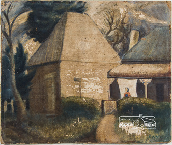
Painting, Lindsay Edward, The Malt House, 1942c
Artist Lindsay Edward and wife Jan built a house designed by Alistair Knox at 151 Old Eltham Road, Lower Plenty. See article on home designed by Alistair Knox for Lindsay Edward, teacher, at 151 Old Eltham Road, Lower Plenty. The home was originally featured on the cover of the January 1953 issue of Home Beautiful magazine and was revisited in the March 1969 issue. See registration record No. 01649. Lindsay Edward Biography: 1919: 26 August Lindsay Maurice Edward was born in Melbourne. 1937: 4 – 9 May Exhibition - Heidelberg art exhibition (SLV collection) 1939: Art student at the National Gallery of Victoria 1940: 7-14 October Exhibition Heidelberg art exhibition. (SLV collection) 1941: November - Exhibition Heidelberg Art Exhibition 1942: Lindsay was an art student living at this 14 Park Cres. Fairfield. Occupation Art student. He most likely painted this painting around this time. c.1942 – 1944: Enlistment for military service in World War 2 in Casino, NSW. 1944: Rank of Sergeant. 1944: Exhibition Seddon Galleries (Melbourne) 1945: Exhibition Seddon Galleries 1946: Exhibition Exhibition of Past Students of the National Gallery of Victoria 1947: Submitted “Self- portrait in the Archibald Prize, Art Gallery of NSW 1948: Lived in London for a year and married a fellow artist ? Knox. 1949: Returned from London 1949: Electoral Roll Residence– 16 Mount Street, Ivanhoe 1950: October Exhibition Stanley Coe Galleries, 435 Bourke Street, Melbourne 1951: 19 Nov. - 9 Dec. Exhibition An exhibition of present day art of Victoria Victorian 1951 Commemoration Committee in conjunction with the Victorian Artists' Society, 1951: (SLV Collection) 1953: October Exhibition Melbourne Contemporary Artists Exhibiton 1954: Exhibition Melbourne Contemporary Artists Exhibition 1958: Victorian artist and educator Lindsay Edward won the £500 prize for the wall decoration of the Queensland Library - . Edward was born in 1919 and had studied at the National Gallery of Victoria. In 1958 he was head of the painting section of the Royal Melbourne Technical College (now RMIT) and had only recently begun experimenting with mosaic. The Centennial mosaic covers a wall 68 feet (20.72 metres) in length and 14 feet (4.26 metres) high. In a Melbourne Age article in July 1958 Edward described the mural as ‘not a literal subject’ rather as ‘a basic formation of organic forms indicating growth and development’. 1960: Exhibition Eltham Art Show (SLV collection) 1963: Exhibition October 28-November 17 - Argus Gallery, 290 Latrobe Street, Melbourne and at Hassall's Roadside Gallery, Eltham and at Gallery A and at Russell Davis Art Gallery. (SLV Collection) 1963, 1967, 1977 and 1980: Electoral Rolls – Residence Old Eltham Road, Lower Plenty. Occupation Teacher 1966: Exhibition Art Show -Austin Hospital Appeal (Heidelberg) (SLV collection) 1970s: Head of Art Department RMIT where he established a fine art collection. 1982: Exhibition Bolitho Gallery Canberra http://nla.gov.au/nla.news-article116467780 1988: 28 July – Exhibition Recent Paintings Darwin Performing Arts Centre (SLV Collection) 1993: Exhibition Solander Gallery, Canberra 2007: January Died and is buried in Eltham Cemetery 2007: Obituary in Age Jun 2, 2007 - LINDSAY Edward's retirement as head of the fine art department at RMIT in August 1979 signalled the end of an important chapter in the art Sources: ART CONTEST. (1939, March 2). The Argus (Melbourne, Vic. : 1848 - 1957), p. 8. Retrieved October 16, 2016, from http://nla.gov.au/nla.news-article12103185 ART EXHIBITION AT HEIDELBERG (1941, November 25). The Argus (Melbourne, Vic. : 1848 - 1957), p. 6. Retrieved October 16, 2016, from http://nla.gov.au/nla.news-article8218682 ART EXHIBITIONS (1945, October 3). The Age (Melbourne, Vic. : 1854 - 1954), p. 7. Retrieved October 16, 2016, from http://nla.gov.au/nla.news-article205639922 EX-GALLERY STUDENTS' SHOW (1946, October 15). The Argus (Melbourne, Vic. : 1848 - 1957), p. 3. Retrieved October 16, 2016, from http://nla.gov.au/nla.news-article22386440 https://www.artgallery.nsw.gov.au/prizes/archibald/1947/ Art World Busy (1949, February 26). The Argus (Melbourne, Vic. : 1848 - 1957), p. 12. Retrieved October 16, 2016, from http://nla.gov.au/nla.news-article22706197 http://nla.gov.au/nla.news-article22781141 ART NOTES (1953, October 13). The Age (Melbourne, Vic. : 1854 - 1954), p. 2. Retrieved October 16, 2016, from http://nla.gov.au/nla.news-article206462733 Design, color in art show (1954, October 5). The Argus (Melbourne, Vic. : 1848 - 1957), p. 9. Retrieved October 16, 2016, from http://nla.gov.au/nla.news-article23453359 https://artcollection.its.rmit.edu.au/?p=rmit-gallery-about Cinema (1993, October 7). The Canberra Times (ACT : 1926 - 1995), p. 7 (Good Times). Retrieved October 16, 2016, from http://nla.gov.au/nla.news-article127509819 Queensland Centenary Artwork (includes image) http://queenswharf.org/places/former-queensland-state-library-wall-decoration-and-sculpture/ Eltham Cemetery http://www.elthamcemetery.com/index.php/search oil on paper board 31.5 x 37.5 cm signed "Edward" lower rightInscribed on back "The Malt House Lindsay Edward 15 Park Cres Fairfield"fairfield, malt house, lindsay edward, home beautiful, home beautiful magazine, alistair knox -
 Eltham District Historical Society Inc
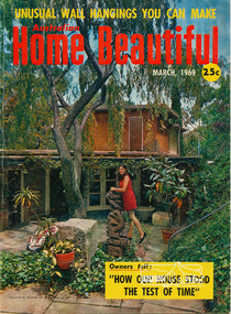
Magazine, Did The House Live Up To Expectations?, Home Beautiful, March 1969, pp6-13, 1969
Article on home designed by Alistair Knox for Lindsay Maurice Edward, teacher, at 151 Old Eltham Road, Lower Plenty. The home was originally featured in Home Beautiful magazine in 1953 and was revisited in the March 1969 issueMagazine, 92 pages , 28.5 cm Digital scan of magazine article saved as searchable PDF documentN/Aalistair knox, home beautiful magazine, lindsay edward, lower plenty, old eltham road, susan edward -
 Eltham District Historical Society Inc
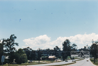
Photograph, M. North, Main Road, Eltham near Fitzsimons Lane Roundabout, Dec 1985, 1/12/85
Two colour photographs of Main Road, ElthamSouth between Falkiner Street and Bolton Street at the roundabout of Fitzsimons Lane, Eltham, Dec 1985Noted on 463B 'See 1934 small black and white snap of flooded bridge and the same two shops. This snap taken from same location, Dec 1985. Old Eltham Park on right of photo The two shops at left (Ansel and Muir) Road ahead crosses new bridge over the Diamond Creek, Eltham Main Road now dual highway, through Lower Plenty to this bridge'main road, eltham, eltham south, fitzsimons lane, round about, falkiner street -
 Eltham District Historical Society Inc
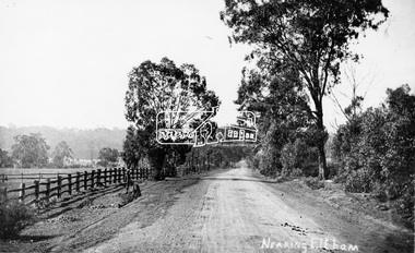
Photograph, Tom Prior, Nearing Eltham, from Research, Vic., c.1905, c.1905
View looking south along the main road from Research to Eltham Part of a presentation, "Roads and Byways of the Shire of Eltham", by Russell Yeoman to the 12 September 1990 Society meeting. Slides shown inclyuded copies of old photos and recent images ranging from the suburban streets of Eltham and Montmorency to the mountain roads of Kinglake. In the byways category are views of some iof the Shire's bicycle paths including then recently completed sections of the Main Yarra Trail at Lower Plenty.This photo forms part of a collection of photographs gathered by the Shire of Eltham for their centenary project book,"Pioneers and Painters: 100 years of the Shire of Eltham" by Alan Marshall (1971). The collection of over 500 images is held in partnership between Eltham District Historical Society and Yarra Plenty Regional Library (Eltham Library) and is now formally known as the 'The Shire of Eltham Pioneers Photograph Collection.' It is significant in being the first community sourced collection representing the places and people of the Shire's first one hundred years. The Reynolds family were early settlers in Research. The Reynolds/ Prior collection of photographs were taken by Tom Prior, the maternal uncle of Ivy Reynolds, around 1900 and the 60 photos in the album give a fine overview of many of the landmarks of Research and Eltham over 100 years ago. lvy lived in the family home for many years at 106 Thompson Cres Research. Ivy's father, Ernst Richard Reynolds and grandfather, Richard Reynolds, lived at the same address. Ivy's father Richard worked for Mr. Trail on his property in Research. Reynolds Road is named after the family. Mr Tom Prior (wife Eva) worked at the Melbourne zoo. He was very innovative and made his own camera, using the black cloth hood to exclude the light. The photographs are a reminder of the rural nature of Research and Eltham and its rich heritage.Digital image (Neg missing)shire of eltham pioneers photograph collection, eltham, main road, research (vic.), reynolds prior collection -
 Eltham District Historical Society Inc
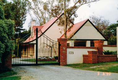
Photograph, Gracedale, 125 Old Eltham Road, Lower Plenty, 3 June 1990, 06/03/1990
... melbourne lower plenty gracedale old eltham road houses Colour ...Colour photographlower plenty, gracedale, old eltham road, houses -
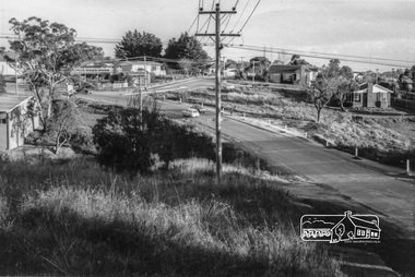
 Eltham District Historical Society Inc
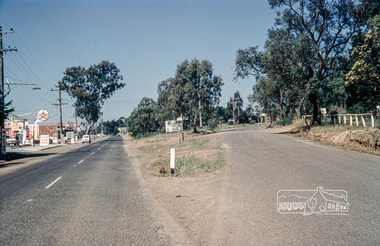
Photograph, Russell Yeoman, Intersection of Old Eltham Road at Main Road, Lower Plenty, c.1965, 1968
... Intersection of Old Eltham Road at Main Road, Lower Plenty... melbourne streets main road lower plenty old eltham road Russell ...Digital file only; created from original colour positive slide transparencystreets, main road, lower plenty, old eltham road, russell yeoman collection -
 Eltham District Historical Society Inc
Photograph, Looking south along Para Road at intersection of Alma Street and Lees Road, Lower Plenty, c.July 1967, 1967
Old community hall (long wall with row of windows) and Lower Plenty Kindergarten visible at corner of Glenauburn and Para Roads. Packaged in "Filmpro King Size prints Definitely Better EST. 1918" envelope. Pencil notes: 36 shots $2.87 Eltham Shire J. McD and 19/7/67. Alma Street and Kett Street Lower Plenty c.July 1967.Black and white photographalma street, glenauburn road, carisbrook crescent, lees road, lower plenty, lower plenty kindergarten, para road, houses, streets