Showing 76 items matching "main yarra trail"
-
 Eltham District Historical Society Inc
Photograph, Liz Pidgeon, Heritage Excursion; Eltham Lower Park Walk and Talk, 1 July 2017, 1 July 2017
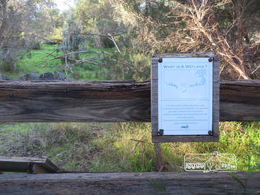
Sign on trail - what is a wetland Newsletter No., 234, June 2017 Heritage Excursion - Saturday 1st July - Eltham Lower Park - Walk and Talk Eltham Lower Park has played an important part in the history of our area since the early days of European settlement when it was used by local residents as an informal racecourse. Prior to that its location at the junction of the Diamond Creek and the Yarra River made it an important meeting place for the Wurundjeri people. The park combines formal elements and sporting facilities with remnant bushland that is of environmental significance. It is home to sporting and horse riding clubs, popular play spaces and the Diamond Valley Miniature Railway, which attracts large numbers of visitors. The park will be the venue for our July excursion which will comprise a walk of about 3.5 km around the park and adjacent areas. Along the way we will discuss the history and natural history of the area. The path along the creek and the river provides a pleasant and scenic walk. This walk on Saturday 1st July is about 3.5 km in length and will take 2 to 2.5 hours. It will start at 2pm at the Main Road car park at the front of the park. (Melway ref 21 H 10). Born Digitalheritage excursion, activities, eltham district historical society, eltham lower park, sign -
 Eltham District Historical Society Inc
Photograph, Liz Pidgeon, Heritage Excursion; Eltham Lower Park Walk and Talk, 1 July 2017, 1 July 2017
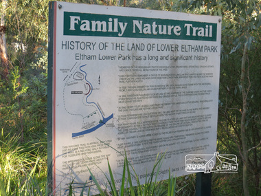
Information Board titled: Family Nature Trail - History of the land of Lower Eltham Park Newsletter No., 234, June 2017 Heritage Excursion - Saturday 1st July - Eltham Lower Park - Walk and Talk Eltham Lower Park has played an important part in the history of our area since the early days of European settlement when it was used by local residents as an informal racecourse. Prior to that its location at the junction of the Diamond Creek and the Yarra River made it an important meeting place for the Wurundjeri people. The park combines formal elements and sporting facilities with remnant bushland that is of environmental significance. It is home to sporting and horse riding clubs, popular play spaces and the Diamond Valley Miniature Railway, which attracts large numbers of visitors. The park will be the venue for our July excursion which will comprise a walk of about 3.5 km around the park and adjacent areas. Along the way we will discuss the history and natural history of the area. The path along the creek and the river provides a pleasant and scenic walk. This walk on Saturday 1st July is about 3.5 km in length and will take 2 to 2.5 hours. It will start at 2pm at the Main Road car park at the front of the park. (Melway ref 21 H 10). Born Digitalheritage excursion, activities, eltham district historical society, eltham lower park, information board, trail -
 Eltham District Historical Society Inc
Photograph, Long Gully and environs, Watsons Creek catchment, c.Oct 1982, 1982
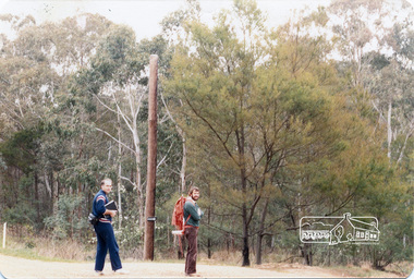
Looking for a route for a walking trail from Kinglake to the Yarra River. Not shown is Rod Roscholler. Colour photograph1982, long gully, watsons creek, lodi francesconi, russell yeoman -
 Eltham District Historical Society Inc
Newsletter, Newsletter, No. 111 November 1996
Contents: • Next meeting, guest speaker; Robert Wuchatsch: Westgarthtown • November Meeting • Christmas Function • Society Headquarters • President’s Report • Spring Excursion • Eltham Heritage Trail • Nillumbik Heritage Study • More News • A Punt Across the Yarra at Eltham? • Former Eltham Shire Office Site The Shire of Eltham Historical Society was formed in October 1967. The first newsletter of the Society was issued May 1978 and has been published continuously ever since on a bi-monthly basis. With the cessation of the Shire of Eltham in late 1994, the Society's name was revised to Eltham District Historical Society and this name first appeared with issue No. 103, July 1995. The collection of the Society's newsletters provides a valuable resource on the history of the Society's activities, office bearers and committee members, guest speakers and subjects of historical interest pertinent to the former Shire of Eltham and the Eltham District.A4 photocopied newsletter distributed to membersnewsletter, eltham district historical society, shire of eltham historical society -
 Eltham District Historical Society Inc
Photograph, 1934 Floods at Eltham
Published in the Diamond Creek Basin Study, 1980 and identified at Diamond Creek, locality not identified, 1934. The location is actually looking south across the Diamond Creek towards Falkiner Street, beside the Main Road bridge at Eltham South from what is now part of Wingrove Park opposite Antoinette Boulevard. The bridge railing is just visible to the left of image. The large leaning Manna Gum beside the bridge still stands in 2021 alongside the Diamond Creek trail. In 1934 extensive flooding of the Yarra River and Diamond Creek set new records for flood plain level (Eltham Chronology, EDHS)Black and white photographCopied by Hugh Fisher, Photographer, 6 York Street Eltham A1678B Floods- Eltham - 1934floods, yarra river, eltham, flooding, diamond creek, flood -
 Eltham District Historical Society Inc
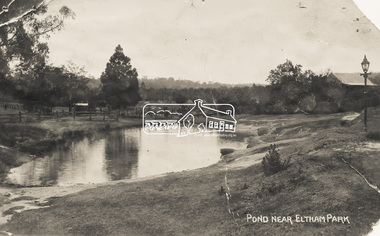
Photograph - Photo Postcard, Pond near Eltham Park, c.1910
This card depicts the pond near Eltham Park (later Eltham Lower Park) circa 1910. The view is taken from Maria Street (Main Road) opposite Dalton Street looking northwest across the Dalton Street road extension reserve (now Wingrove Park Trail) and Jarrold farm. A haystack is visible. Also visible is a gas streetlight and White Cloud cottage which belonged to the Jarrold family From the same collection as accession no. 00778, (Yarra at Eltham) - sent from Eltham and addressed to "Mr J. L. Brown, "Elthamville", Tinning Street, Brunswick" "with love from Nellie" who was most probably a member of the extended Brown family, and no. 00780 (Eltham, J.H. Clark Photo - dated 20 May 1911). Sending postcards to family and friends including short messages was a common form of communication in the early 20th century. Part of a slide show presentation "Bridges & Waterways of the Shire" by Russell Yeoman to the 13 September 1989 Society meeting. The presentation included slides of historic photos from the Shire of Eltham Pioneers collections as well as several recent views.Sending postcards to family and friends including short messages was a common form of communication in the early 20th century.Sepia postcard in very poor condition which has been removed from an album. Glue residue and album page adhering preventing information being readFront: Pond near Eltham Parkpostcard, eltham, pond, dalton street, duck pond, eltham park, elthamville, gas lamp, haystack, jarrold cottage, jarrold property, main road, maria street, white cloud cottage, wingrove park trail -
 Eltham District Historical Society Inc
Photograph, Odyssey House Victoria, 28 Bonds Road, Lower Plenty, 6 March 1990
Odyssey House drug rehabilitation centre in Bonds Road, Lower Plenty is a distinctive landmark, especially when viewed from across the Yarra at Templestowe. It was built in the 1950’s as a seminary for the Blessed Sacrament Fathers. Because of the poor and circuitous road access, a suspension footbridge was built across the river. As well as providing easy access for the priests residents of Templestowe could attend services at the seminary. The bridge is now part of the Yarra Trails system.Colour photographlower plenty, bonds road, odyssey house -
 Eltham District Historical Society Inc
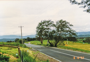
Photograph, Widened road reserve near Memorial Tower, Eltham-Yarra Glen Road, Kangaroo Ground, 6 December 1992, 06/12/1992
The Eltham Horse Trail: Research and Warrandyte to Kinglake: Survey of proposed route, December 1992: (2) Warrandyte to Kangaroo GroundColour photographeltham horse trail (1992 survey), kangaroo ground, eltham-yarra glen road, war memorial tower -
 Eltham District Historical Society Inc
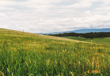
Photograph, Looking north from Eltham-Yarra Glen Road, Kangaroo Ground, 6 December 1992, 06/12/1992
The Eltham Horse Trail: Research and Warrandyte to Kinglake: Survey of proposed route, December 1992: (2) Warrandyte to Kangaroo Ground, trail route to be determined (1992)Four colour photographseltham horse trail (1992 survey), kangaroo ground, eltham-yarra glen road -
 Eltham District Historical Society Inc
Photograph, Barak Bushlands Reserve, Eltham, March 2003, 2003
This area is urban and wetlands west of the Eltham gateway approach near the bridge over Diamond Creek and forms part of a walking trail. On 15 August 2004, the Shire of Nillumbik officially named the area "Barak Bushlands" as part of its commitment to Aboriginal reconciliation. The naming day memorialised the one hundred and first anniversary of the death of the last full-blood Yarra Aboriginal leader, William Barak. Source: Aboriginal reconcilation events in Nillumbik, Ken Eckersall, 2006.Digital scan from borrowed photobarak bushlands reserve, eltham, walking trail -
 Monbulk RSL Sub Branch
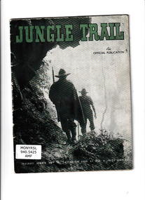
Book, Dept. of the Army, Jungle trail : an official publication : a story of the Australian soldier in New Guinea, 1944
Australian army brochure describing the New Guinea campaign in 1942 -1943Ill, p.32.non-fictionAustralian army brochure describing the New Guinea campaign in 1942 -1943world war 1939 – 1945 – campaigns – new guinea, world war 1939 – 1945 – campaigns – kokoda -
 Monbulk RSL Sub Branch
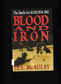
Book, Hutchinson, Blood and Iron : The Battle for Kokoda 1942, 1991
An account of the Kokoda campaign in 1942 with the Japanese side also described in some detailIndex, notes, ill, maps, p.413.non-fictionAn account of the Kokoda campaign in 1942 with the Japanese side also described in some detailworld war 1939 – 1945 – campaigns – kokoda, kokoda trail - new guinea -
 Monbulk RSL Sub Branch
Book, Robyn Kienzle, The architect of Kokoda: Bert Kienzle - the man who made the Kokoda trail, 2011
Biography of Bert Kienzle who established a trail across the Owen Stanley ranges.Index, bibliography, ill (plates), p.327.non-fictionBiography of Bert Kienzle who established a trail across the Owen Stanley ranges.kienzle herbert thompson 1905-1988, kokoda trail (papua new guinea) -
 Monbulk RSL Sub Branch
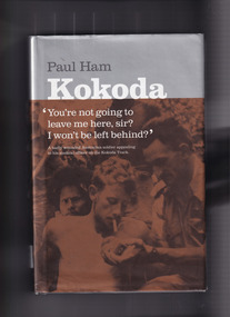
Book, Paul Ham, Kokoda, 2004
For the first time ever, the compelling story of the infamous Kokoda Track campaign has been told from both sides of the conflict. In a unique and balanced portrayal, renowned journalist Paul Ham recounts both the Australian and Japanese perspectives of the events on the hellish Papuan jungle trail where thousands fought and died during World War II. Based on extensive research in Australia and Japan, and including previously unpublished documents, Kokoda intimately relates the stories of ordinary soldiers in 'the world's worst killing field', and examines the role of commanders in sending ill-equipped, unqualified Australian troops into battles that resulted in near 100 per cent casualty rates. It was a war without mercy, fought back and forth along 90 miles (145 km) of river crossings, steep inclines and precipitous descents, with both sides wracked by hunger and disease, and terrified of falling into enemy hands. Defeat was unthinkable: the Australian soldier was fighting for his homeland against an unyielding aggressor; the Japanese ordered to fight to the death in a bid to conquer 'Greater East AsiaIndex, bib, ill, p.602.non-fictionFor the first time ever, the compelling story of the infamous Kokoda Track campaign has been told from both sides of the conflict. In a unique and balanced portrayal, renowned journalist Paul Ham recounts both the Australian and Japanese perspectives of the events on the hellish Papuan jungle trail where thousands fought and died during World War II. Based on extensive research in Australia and Japan, and including previously unpublished documents, Kokoda intimately relates the stories of ordinary soldiers in 'the world's worst killing field', and examines the role of commanders in sending ill-equipped, unqualified Australian troops into battles that resulted in near 100 per cent casualty rates. It was a war without mercy, fought back and forth along 90 miles (145 km) of river crossings, steep inclines and precipitous descents, with both sides wracked by hunger and disease, and terrified of falling into enemy hands. Defeat was unthinkable: the Australian soldier was fighting for his homeland against an unyielding aggressor; the Japanese ordered to fight to the death in a bid to conquer 'Greater East Asiaworld war 1939 – 1945 – campaigns – kokoda, world war 1939-1945 - campaigns - south west pacific -
 Mrs Aeneas Gunn Memorial Library
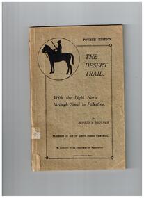
Book, Department of Repatriation, The desert trail : with the Light Horse through Sinai to Palestine, 1919
A persona account of the light horse in PalestineIll, p.129.A persona account of the light horse in Palestineworld war 1914-1918 - australian light horse, world war 1914-1918 - campaigns - middle east -
 Heidelberg Golf Club
Book, Melbourne Parks and Waterways, Lower Plenty River concept plan: Maroondah Pipe Track to Yarra River, 1994
Lower Plenty River concept plan: Maroondah Pipe Track to Yarra River. Includes suggestion of Plenty River Trail along the west boundary of the Heidelberg Golf Club.66 p., illus., colour map. Also, Draft copy of document.plenty river trail, lower plenty river, heidelberg golf club, mmbw, melbourne parks and waterways