Showing 84 items matching "map of clunes"
-
 Clunes Museum
Document - BOOKLET & POSTCARDS, "THE DAY THE KELLY GANG PUT EUROA ON THE MAP"
BOOKLET ISSUED BY THE EUROA HISTORICAL SOCIETY INC..1 BOOKLET ON THE KELLY GANG HOLDING UP THE NATIONAL BANK AT EUROA - DECEMBER 10TH 1878. .2.3 TWO SEPIA POSTCARDS OF THE EUROA BANK WITH SEVERAL POLICE AND LOCALS STANDING ABOUT THE FRONT OF THE BUILDING .4 POSTCARD DEPICTING SOUVENIRS THE SERVICE CARD OF ROBERT DAVID BOOTH DATED MAY 1877 WITH INSET IMAGES OF A LEAD BALL AND A DISFIGURED SIXPENCElocal history, books, history, local history., euroa museum -
Clunes Museum
Work on paper - SKETCH BOOK
THE STUDENT MAY HAVE BEEN MARIA DUNN WHO ATTENDED THE ST. THOMAS R. C. SCHOOLA SCHOOL BOOK OF MAPS, HAND PRODUCED BY SCHOOL STUDENTSSEE OVERlocal history, book, school, education, schools, st. thomas aquinas -
Clunes Museum
Map, F.W. NIVEN EMBOSSER
... Clunes Museum 36 Fraser Street Clunes goldfields LOCAL ...SCROLL - SURVEVOR MAP AND PLAN OF NEW CRESWICK GOLD FIELDS SURFACE LEVELSlocal history, document, maps, mining - maps -
Clunes Museum
Map - MAPS/DOCUMENTS
INFORMATIONDOCUMENTATION AND MAPS DESCRIBING THE WORKINGS OF THE PORT PHILLIP MINE, SHOWING 54 FEET DEEP OF THE UNDERGROUND WORKINGS.local history, mining, port phillip mine -
Clunes Museum
Document - SURVEYORS MAP, A.C. BROOKS GOVERNMENT PRINTER MELBOURNE, 1937
NO.2 COPY OF NOTES TAKEN FROM DIARY 1865 THOUGHT TO BE WRITTEN BY JESSE HOARE SMITH WHO WAS A SURVEYOR AT CLUNES AT THE TIME. DIARY TURNED UP IN NORTH QUEENSLAND AND NOW IN POSSESSION OF A CRESWICK MAN.NO.1 SURVEYORS MAP TALBOT AND SURROUNDING TOWNS 1937. NO.2 DIARY NOTES 1865 THOUGHT TO BE WRITTEN BY JESSE HOARE SMITHlocal history, documents, maps, weickhardt, wattleworth -
Clunes Museum
Pamphlet, Clunes Historic Gold Town Victoria
... the history of Clunes and depicts points of interest with map of area ....1 Foolscap brochure folded in 4, coloured and black and white photos of Clunes. Text outlines the history of Clunes and depicts points of interest with map of area on back. .2 Foolscap brochure folded in 4, coloured and black and white photos of Clunes. Text outlines the history of Clunes and depicts points of interest with map of area on back.clunes gold town, clunes attractions, clunes history -
Clunes Museum
Memorabilia - BANNER
Clunes Lion's Club operated 1975-1998.1 Lions International Badge. Adhesive emblem of yellow and royal blue, large white "L" in centre circle, lion's face, facing outwards on either side. "LIONS" at top "International" at bottom .2 Small banner, white with red fringe, red cord at top. Map of Victoria, pictures showing mining, sheep, trees at top .1 "Lions International" .2 "Clunes Lions Club" 201VA, Gold 'n' Fleece, Victoria, Australiaclunes lions club, lions club emblem -
 Clunes Museum
Document - MAP
... PHOTOCOPY OF CLUNES TOURELLO WATER SHED. Document MAP ...PHOTOCOPY OF CLUNES TOURELLO WATER SHED.local history, photography, photographs, water supply -
 Clunes Museum
Document - MAP
... FOR THE CLUNES TOWNSHIP AND MINES. Document MAP ...PHOTO COPY. WATERSHED DAMS WEIR CREEK FOR THE COLLECTION OF WATER FOR THE CLUNES TOWNSHIP AND MINES.local history, photography, photographs, water supply -
 Clunes Museum
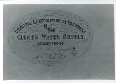
Document - MAP
CLUNES WATER SUPPLY DRAWINGS & DESCRIPTIONS OF THE WORKS PRESENTED TO P.F. ADAMS ESQUIRE SURVEYOR GENERAL OF NEW SOUTH WALES WITH OCT. LANGHAMS COMP.DRAWINGS AND DESCRIPTIONS OF THE WORKS OF CLUNES WATER SUPPLY.local history, photography, photographs, water supply -
 Bendigo Historical Society Inc.
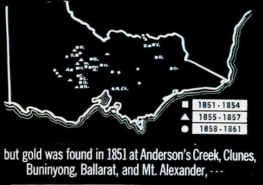
Slide - DIGGERS & MINING. THE GOLD ERA, c1851
BHS CollectionDiggers & mining. But gold was found in 1851 at Anderson's Creek, Clunes, Buninyong, Ballarat, and Mt. Alexander, - - - Slide shows map of Victoria with legend to show when gold was found in different areas. The gold era. Markings 4 994.031 GOL:5. Used as a teaching aid. Used as a teaching aid.hanimounteducation, tertiary, goldfields -
 Bendigo Historical Society Inc.
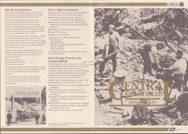
Document - CENTRAL GOLDFIELDS RESTORATION FUND, March 1986
Pamphlet on the Central Goldfields Restoration Fund issued by the Victorian Ministry for Planning and Environment. Includes a map of the central goldfields region, introduction by Jim Kennan (Minister) and 3 photographs. Also a description on how the fund operates and how to apply for assistance. An insert of 2 blank application forms. Photos show , Miners using a sluice at Tarnagulla c.1880. Cnr of Sturt and Lydiard Sts, Ballarat c.1880. E. Eberhard Cordial Factory at Clunes c.1890.Victorian Ministry for Planning and Environmentorganization, government, central goldfields, restoration fund, ministry for planning and environment, j. kennan, tarnagulla, ballarat, clunes. -
Clunes Museum
Pamphlet - BROCHURE, Shire of Talbot and Clunes, Clunes Walking Tour, 1988
... , Clunes town map on reverse of brochure, image of Clunes Town Hall...Map Clunes Walking Tour 50c hand written in lead pencil ...Folded black and white brochure with 56 points of interest, Clunes town map on reverse of brochure, image of Clunes Town Hall on front of brochure Multiple Copies50c hand written in lead pencil on front page Ramsay House 13 hand written in pencil on front page Text? Clunes Cemetery hand written in biro on front page Hand written in biro, Richard Ford built the bungalow he did not live there, he lived in Smith Street this is an error in the conservation studymap, clunes walking tour -
Clunes Museum
Booklet - PROGRAM, CLUNES BOOKTOWN 2022
.1 PROGRAMME BOOKLET FOR CLUNES BOOKTOWN 30/4-1/05/2022 .2 MAP AND LOCATIONS OF EVENTS BOOKTOWN 2022clunes booktown, booktown 2022 -
Clunes Museum
Booklet - PROGRAM, CREATIVE CLUNES, CLUNES BOOKTOWN 2024, MARCH 2024
... CLUNES BOOKTOWN FESTIVAL BOOKTOWN EVENTS CLUNES PROGRAM ...CLUNES BOOKTOWN FESTIVALCLUNES BOOKTOWN FESTIVAL PROGRAM 23-24 MARCH 2024. 36 PAGE PROGRAM WITH PURPLE COVER STAPLED. 2 COPIES. FESTIVAL MAP INSERTbooktown, events, clunes, program -
Clunes Museum
Book - BUSINESS DIRECTORY, UNIVERSAL BUSINESS DIRECTORIES (AUST) PTY LTD, UBD BUSINESS AND STREET DIRECTORY 1971, 1971
BUSINESS AND STREET DIRECTORY OF BALLARAT AND SURROUNDING DISTRICTSRED COVERED DIRECTORY WITH MAP OF VICTORIA ON THE COVER. 36 PAGES OF BUSINESS ADVERTISING AND ADDRESSES WITH SOME MAPS OF BALLARAT AND SURROUNDING DISTRICTS. PAGE 46 SHOWS CLUNES BUSINESSES.non-fictionBUSINESS AND STREET DIRECTORY OF BALLARAT AND SURROUNDING DISTRICTSregional businesses, clunes businesses -
Clunes Museum
Ephemera - DOCUMENT, CREATIVE CLUNES, CLUNES BOOKTOWN FESTIVAL, MARCH 2025
CLUNES BOOKTOWN FESTIVAL 22-23 MARCH 2025 .1 2025 BOOKMARK. ORANGE BACKGROUND, PRINTED BOTH SIDES. 3 COPIES .2 2025 PROGRAM WITH MAP. FULL COLOUR, PRINTED BOTH SIDES FOLDED TO BE POCKET SIZE - 10.5 X 15 cm. 2 COPIES .3 2025 WALKING TOUR LAMINATES ( 2 COPIES) .4 2008 BACK TO BOOKTOWN BOOKMARK. PRINTED BOTH SIDES HIGH GLOSS2025 clunes booktown, 2008 back to booktown, publicity -
Clunes Museum
Map - CLUNES TOWN HALL AND COURTHOUSE COMPLEX, FALKINGER ANDRONAS
... EAST ELEVATION .4 WEST ELEVATION .5 ABC/FASCADES Map CLUNES ...CLUNES TOWN HALL AND COURT HOUSE COMPLEX - PROPOSED REFURBISHMENT ARCHITECT DRAWINGS: ,1 SITE AND ROOF PLAN .2 GROUND FLOOR PLAN .3 EAST ELEVATION .4 WEST ELEVATION .5 ABC/FASCADEStown hall and courthouse drawings, proposed refurbishment -
Clunes Museum
Plan - Map, Clunes Caravan Park Amenities Block
Four copies of draftsman plans for the amenities block at the Clunes Caravan Park, one copy has been amended with red penSigned by R. A. Boyd 12/71 Engineercaravan park, amenities upgrade -
Clunes Museum
Map - MAPS, A.C. BROOKS GOVERNMENT PRINTER MELBOURNE
.1 PARISH OF CLUNES, COUNTY OF TALBOT. (3 COPIES) (1) STAMP: DRAWING OFFICE RECORDS COPY, STATE ELECTRICITY COMMISSION OF VICTORIA. ELECTRICITY DEPARTMENT (THIS PLAN MUST NOT BE TAKEN FOR FIELD USE. PLEASE DO NOT DEFACE) C71 ON LEFT BOTTOM CORNER, CLUNES SHEET 1 (2) '19' HANDWRITTEN ON ALL FOUR CORNERS AND PLASTIC TAB FOR HANGING (3) PLASTIC TAB FOR HANGING .2 MAP BECKWORTH COUNTY OF TALBOT (3 COPIES) (1) IN RED: B-61. L.4855. THE ALLOTMENTS COLOURED BROWN ARE FREEHOLD (2) WITH PLASTIC TAB FOR HANGING (3) WITH PLASTIC TAB FOR HANGING. '14' HAND WRITTEN IN ALL 4 CORNERS AND VARIOUS PENCIL NOTATIONS ON THE MAP..1.2 DRAWN AND REPRODUCED AT THE DEPARTMENT OF LANDS & SURVEY MELBOURNE. PRICE 2/- .1 IN PENCIL ON BOTTOM ' 211 ' 20%parish of clunes, electricity supply department, beckworth -
Clunes Museum
Map, Surface Geology Plan
Plans show various shaft locations.1 Photocopy of Plan Block 23/19 Scale 1 inch = 100 feet .2 Photocopy of Plan Block 19/19 Scale 1 inch = 100 feet .3 AERIAL PHOTOGRAPH WITH WORKINGS MARKED - LAMINATED.1 C-21 North Broken Hill Ltd Clunes Block 23/19 .2SOUTH CLUNES MINE Ltd Clunes Block 19/19north broken hill ltd, surface geology plan -
Clunes Museum
Map, 1890
Features location of Club Hotel, Union Bank, Engine rooms, Port Phillip Hotel, Pyrites furnace, Battery, Office, Smith Shop,Surface Tramway to BatteryPhotocopy of map/plan of Dixon's New North Clunes, Central Clunes Co. and South Clunes utd showing various shafts and pre-emptive rights. Scale 1 inch = 100 feetOn front in red ink; "drawn in 1890"mine shafts, hotels, plans -
 Federation University Historical Collection
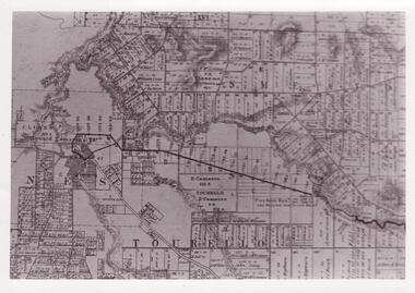
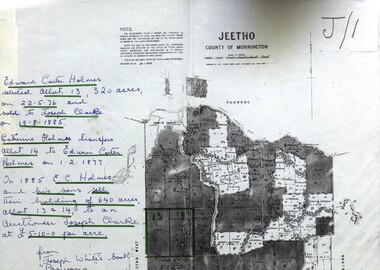
Map - Documents, Documents relating to Land - Selection of Maps of subdivisions; Titles; Cemetery sections
Maps indicate the land owned in various areas of Victoria - Mornington Peninsula, Ascot / Creswick areaLand maps showing block divisions and owners. Edward Carter Holmes J.P. selected land and called it Launchley - later called Wambalano.jeetho, county of mornington, edward carter holmes, joseph clarke, catherine holmes, talbot, william coghill, pre-emptive right, tourello pre-emptive right, glendonald pre-emptive right, clunes, smeaton, ascot, counties of ripon and talbot, certificate of title, ballaarat general cemetery, new cemetery, poowong, helen coghill -
 Federation University Historical Collection
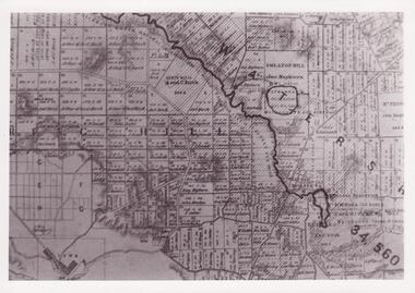
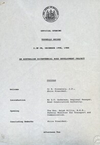
Document - Documents, Tourello: Opening of Tourello Bridge; Tourello Hunt Club, 1909; Tourello Tennis Club; Government Land Auction, 1855
Maps and typed documentstourello bridge, hunt club, tennis club, government land auctions, talbot, clunes, coghill, lenaghan, peter lalor, r. kinnersly, d.t. anderson, ralph willis, creswick