Showing 2633 items
matching map of victoria
-
 Wodonga & District Historical Society Inc
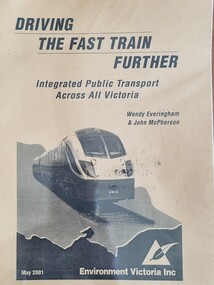
Booklet - Driving the Fast Train Further, Wendy Everingham and John McPherson, May 2001
... superimposed over an outline map of Victoria. It consists of 36 pages..., a map of an Environment Victoria Enhanced Victorian Passenger ...This document is a response by Environment Victoria to the Fast Train Report. It advocates the establishment of an integrated transport approach in Victoria including the need for a Rural and Regional Planning Strategy to be developed in conjunction with the Metropolitan StrategyA publication of 34 pages produced by Environment Victoria Inc. It has brown cover featuring an image of a locomotive superimposed over an outline map of Victoria. It consists of 36 pages including appendices, references, a map of an Environment Victoria Enhanced Victorian Passenger Rail Network and a map of the Victoria's Regional and Rural Bus service.fiction This document is a response by Environment Victoria to the Fast Train Report. It advocates the establishment of an integrated transport approach in Victoria including the need for a Rural and Regional Planning Strategy to be developed in conjunction with the Metropolitan Strategyrailways environmental impact, victorian railways, environment victoria -
 Glenelg Shire Council Cultural Collection
Pamphlet - Brochure - Portland, n.d
... Point light house on front cover, Glenelg river and map.... Anderson Point light house on front cover, Glenelg river and map ...'Bower Bird', Museum, HeywoodFull-colour, tri fold brochure promoting Portland. Anderson Point light house on front cover, Glenelg river and map of Victoria on reverse. -
Glenelg Shire Council Cultural Collection
Pamphlet, Tourist Guide to the South West Region, n.d
... Pamphlet, Tourist Guide to the South West Region. Map... Region. Map of Victoria on one side, with areas of interest ...Pamphlet, Tourist Guide to the South West Region. Map of Victoria on one side, with areas of interest numbered. Reverse has details for each number.tourism, walking, tourist information, south west, map -
Tatura Irrigation & Wartime Camps Museum
Book, History of Valvers of Water Commmission of Victoria 1905 - 1994, 2014
... Rivers and Water Supply Commission map of Victoria water storage... Supply Commission map of Victoria water storage information ...Includes names of valvers who served in TaturaBlue and white front cover. Taken at a conference. State Rivers and Water Supply Commission map of Victoria water storage information on back covervictoria state rivers and water supply commission -
Friends of Ballarat Botanical Gardens History Group
Work on paper - Victoria Park Precinct, City of Ballarat, Victorian Heritage Database place details -19/9/2017, 19/9/2017
... 6 pages of print. p.1. is a front page with a map.... is a front page with a map and Victoria Park marked in purple ...Victoria Park is associated with gold mining in the 1860's, military manoevres in the late 19th century; as an army base during World War 2 and a recreation area.Victoria Park is a "landmark cultural landscape" in the city of Ballarat. This parkland established 1890-1910, was modelled on English country estates and London Parks. It demonstrates the civic pride of Ballarat citizens and is an important parkland for the local community. There is a collection of exotic and early planted native trees and areas of native grasslands.6 pages of print. p.1. is a front page with a map and Victoria Park marked in purple with a bibliography on p.4 and footnotes on p.6.None.john garner, victoria park, friends of ballarat botanical gardens, heritage overlay, gold mining, parkland, late nineteenth century, native grasslands, exotic and native trees, royal park, mullock heap, mount holled-smith, arbor day, messrs clegg&nicholls, william guilfoyle, w.o.allen, significant tree register, john garner collection, gardens, ballarat -
 Marysville & District Historical Society
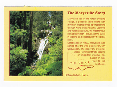
Postcard (item) - Colour postcard, Neil Cutts, The Marysville Story-Steavenson Falls, Pre 2009
... of Marysville as well as a map of Victoria with the location... of Marysville as well as a map of Victoria with the location ...A postcard in a series produced by the Rose Stereograph Company in Victoria, Australia as a souvenir of Marysville.A colour photograph of Steavenson Falls in Marysville, Victoria. The Steavenson Falls is named after the Victorian Assistant Commissioner of Roads and Bridges, John Steavenson, who arrived in Victoria in the early 1860s. At 84 metres high, Steavenson Falls is Victoria's tallest cascading waterfall. The falls are split into roughly five cascades, with the last of these plunging into a small, picturesque rock pool. Rose Series Postcard No. 3530. The Marysville Story/ Marysville lies in the Great Dividing/ Range, a peaceful town where lush/ mountain forests provide a perfect setting/ for bush walks or just relaxing. Lookouts/ and waterfalls abound, the most famous/ being Steavenson Falls, one of the tallest/ in Victoria and spectacularly floodlit at/ night./ Established in 1863, Marysville was/ named after the wife of surveyor John/ Steavenson. The discovery of gold at/ Woods Point meant that it became/ an important stopover for/ diggers on their/ way to the/ goldfields. Steavenson Falls POST CARD The "Rose" Series/ De Luxe Proudly Printed in/ Australia Since 1880 AFFIX/ STAMP/HERE/ Rose Series/ Post Card No./ 3530 ADDRESS/ POSTCODE the MARYSVILLE STORY & Steavenson Falls/ MARYSVILLE, VICTORIA, AUSTRALIA/ Photo Neil Cutts Copyright Rose Stereograph Co., Glen Waverley, Victoria (03) 9560 7772marysville, steavenson falls, victoria, postcard, souvenir, rose stereograph co, 3530, john steavenson -
 Marysville & District Historical Society
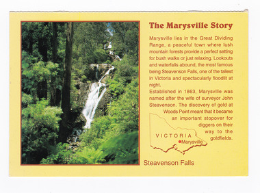
Postcard (item) - Colour postcard, Neil Cutts, The Marysville Story-Steavenson Falls, Pre 2009
... of Marysville as well as a map of Victoria with the location... of Marysville as well as a map of Victoria with the location ...A postcard in a series produced by the Rose Stereograph Company in Victoria, Australia as a souvenir of Marysville.A colour photograph of Steavenson Falls in Marysville, Victoria. The Steavenson Falls is named after the Victorian Assistant Commissioner of Roads and Bridges, John Steavenson, who arrived in Victoria in the early 1860s. At 84 metres high, Steavenson Falls is Victoria's tallest cascading waterfall. The falls are split into roughly five cascades, with the last of these plunging into a small, picturesque rock pool. The Rose Series postcard No. 3530. The Marysville Story/ Marysville lies in the Great Dividing/ Range, a peaceful town where lush/ mountain forests provide a perfect setting/ for bush walks or just relaxing. Lookouts/ and waterfalls abound, the most famous/ being Steavenson Falls, one of the tallest/ in Victoria and spectacularly floodlit at/ night./ Established in 1863, Marysville was/ named after the wife of surveyor John/ Steavenson. The discovery of gold at/ Woods Point meant that it became/ an important stopover for/ diggers on their/ way to the/ goldfields. Steavenson Falls POST CARD The "Rose" Series/ De Luxe Proudly Printed in/ Australia Since 1880 AFFIX/ STAMP/HERE/ Rose Series/ Post Card No./ 3530 ADDRESS/ POSTCODE the MARYSVILLE STORY & Steavenson Falls/ MARYSVILLE, VICTORIA, AUSTRALIA/ Photo Neil Cutts Copyright Rose Stereograph Co., Glen Waverley, Victoria (03) 9560 7772marysville, steavenson falls, victoria, postcard, souvenir, rose stereograph co, 3530, john steavenson -
Glenelg Shire Council Cultural Collection
Administrative record - Annual Report - Portland Harbour Trust, 1972, c. 1972
... , white, map of Victoria... covers, glossy, brown, aqua, white, map of Victoria ...Twenty-first Annual Report, Portland Harbour Trust for year ending 30 June 1972. Heavy card covers, glossy, brown, aqua, white, map of Victoriaportland harbour trust, annual report, administrative record -
Clunes Museum
Book - BUSINESS DIRECTORY, UNIVERSAL BUSINESS DIRECTORIES (AUST) PTY LTD, UBD BUSINESS AND STREET DIRECTORY 1971, 1971
... RED COVERED DIRECTORY WITH MAP OF VICTORIA ON THE COVER. 36... RUEDIN RED COVERED DIRECTORY WITH MAP OF VICTORIA ON THE COVER ...BUSINESS AND STREET DIRECTORY OF BALLARAT AND SURROUNDING DISTRICTSRED COVERED DIRECTORY WITH MAP OF VICTORIA ON THE COVER. 36 PAGES OF BUSINESS ADVERTISING AND ADDRESSES WITH SOME MAPS OF BALLARAT AND SURROUNDING DISTRICTS. PAGE 46 SHOWS CLUNES BUSINESSES.non-fictionBUSINESS AND STREET DIRECTORY OF BALLARAT AND SURROUNDING DISTRICTSregional businesses, clunes businesses -
Glenelg Shire Council Cultural Collection
Administrative record - Progress Report of Portland Harbour - Royal Commission of Victoria, 1925
... maps of Victoria, Portland and harbour and aerial photographs..., Portland harbour, dated 1925. Includes maps of Victoria, Portland ...Retrieved from the files of the former Maritime Discovery Centre Manager at the Portland Information Centre (A copy of this report is listed in the manifest from the Port of Portland when collection was offered in 1995)Front: Capt. J W Brown -inkport of portland -
Glenelg Shire Council Cultural Collection
Souvenir - Souvenir Car Transfer / Sticker (a) Order form (b) - Melbourne, Victoria, n.d
... marked on map of Victoria, including Portland. (b) order form...', Melbourne and various cities marked on map of Victoria, including ...(a) Coloured souvenir sticker of Victoria, coat of arms, sign on wooden stake 'VICTORIA', Melbourne and various cities marked on map of Victoria, including Portland. (b) order form for Art Colour transfers -
National Wool Museum
Map
... Map of Victoria, with shaded areas designating the WSS Wool...-and-the-bellarine-peninsula Map of Victoria, with shaded areas designating ...Map of Victoria, with shaded areas designating the WSS Wool Areas for Victoria, southern New South Wales and the western part of South Australia.wool brokering wool sales, wool brokering, wool sales -
 Melbourne Tram Museum
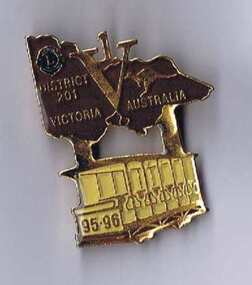
Ephemera - Badge, Douglas badges for Lions club District No. 201, 1995
... , featuring a map of Victoria with the letter V and number 1 included... by the Lions District No. 201, Vic, featuring a map of Victoria ...Badge - issued by the Lions District No. 201, Vic, featuring a map of Victoria with the letter V and number 1 included in the map, featuring a Box Hill toastrack style tramcar under the badge with the numbers 95-96 on the front of the tram. Gold badge with brown paint infill in the map of Victoria and a yellow paint infill on the tram finished with a gloss varnish. Has a pin clip on the rear with a locking mechanism. Made by Douglas batches of Melbourne - has their phone number on the rear.trams, tramways, box hill, badges, lions club -
Whitehorse Historical Society Inc.
Map, Proposed Mullum Mullum Park, 6/05/2008
... Map produced by Parks Victoria.... Victoria. Map produced by Parks Victoria. Proposed Mullum Mullum ...Map produced by Parks Victoria.Map produced by Parks Victoria.Map produced by Parks Victoria.mullum mullum park, maps -
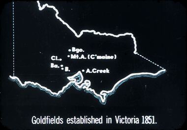 Bendigo Historical Society Inc.
Slide - DIGGERS AND MINERS. DIGGERS AND MINERS, c1851
... Diggers and miners. Diggers and Miners. Map of Victoria... and Miners. Map of Victoria shows Bgo. Mt. A. (C'maine) Cl. Ba. B ...Diggers and miners. Diggers and Miners. Map of Victoria shows Bgo. Mt. A. (C'maine) Cl. Ba. B. A. Creek. Goldfields established in Victoria 1851. Markings: 11 994.5 WAL. Used as a teaching aid.hanimounteducation, tertiary, goldfields -
Federation University Historical Collection
Map - Plan, Ballarat Deep Leads and Mines, 1992, 1992
... Map - Gold Mines in Victoria... in Victoria. Map No.6 Ballarat Sheet 1 of 2 The map shows geology... on the bottom rhs with a map of Victoria superimposed over a poppet head... This is Bulletin No. 62: Deep Lead Gold Deposits in Victoria. Map No.6 ...This is Bulletin No. 62: Deep Lead Gold Deposits in Victoria. Map No.6 Ballarat Sheet 1 of 2 The map shows geology, topography and information on mines in the following areas: one large map of the Ballarat area with five enlargements for: Sago Hill District; Scarsdale District; Pitfield Plains District; Berringa Gold Field and Rokewood District. Ballarat Mines and Deep Leads Report No.94 (Finlay and Douglas,1992) provides a summary of the Geological Survey of Victoria mines database, references and geology for most of the mines on this map. Geology Compilation: simplified from earlier Departmental mapping with minor field checking by E.N.M. Plier-Malone. Very large rectangular sheet of paper with seven coloured maps of various sizes and a small green rectangle on the bottom rhs with a map of Victoria superimposed over a poppet head. this rectangle includes information of the other maps shown. The background for these maps is white. Also includes tables of names of mine companies, name of shafts and gold production.gold mines of australia, gold mines of victoria, gold mines- ballarat and district, gold mines pitfield plains district, gold mines scarsdale district, gold mines berringa gold field, gold mines rokewood district, gold mines sago hill district, map - gold mines, map - gold mines in victoria, ballarat, pitfield, scarsdale, berringa, rokewood, sago hill, deep lead gold deposits in victoria, geological survey - gold deposits in victoria, mining, gold deposits in victoria, gold mines in victoria, rokewook, pitfield plains -
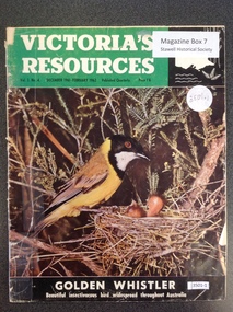 Stawell Historical Society Inc
Book, Natural Resources Conservation, Victoria's Resources - Vol 3 No 4, 1962
... . Black section containing map of Victoria below a colour picture... with white & black print. Black section containing map of Victoria ...Departments, Regions, Municipalities and Organisations which are members of the Conservation League. These books were provided free of charge to residents.Paper cover: 3/4 Green strip with white & black print. Black section containing map of Victoria below a colour picture of a nesting mother bird with chicks below black strip with white printVictori's Resources Vol 3. No. 4. December 1961 February 1962. Published Quarterly Price 1'6 Golden Whistler Beautiful Insectivorous bird widespread thoughout Australiatourism -
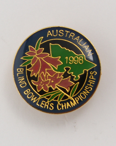 Vision Australia
Badge - Object, Australian Blind Bowlers Championships 1988, 1988
... of the map of Victoria in green. Floral design in pink and green... circular badge with enamel front, back pin and part of the map ...Gold circular badge with enamel front, back pin and part of the map of Victoria in green. Floral design in pink and green on dark blue background with gold lettering.Gold enamel circular badge with gold writing and outline of Victoria and pink heath (state emblem)Australian Blind Bowlers Championships 1988recreation, badges -
Glenelg Shire Council Cultural Collection
Map - Map - Western Victoria / South Australia, n.d
... Map - Western Victoria / South Australia...Black and white photographic copy of a map of Western... photographic copy of a map of Western Victoria and some of South ...Port of Portland Authority Archivesport of portland archives -
Tatura Irrigation & Wartime Camps Museum
Book, The Tatura Secret Radio, 1997
... . The front cover depicts a man with headphones on. A map of Victoria... with headphones on. A map of Victoria and short history of the book ...Army Intelligence knew there was a secret radio operating in Tatura No.1 Camp. The inmates were getting the war news direct from Germany. They had to have a strong shortwave receiver, but where was it?White soft cover book with an entrance made with barb wire. The front cover depicts a man with headphones on. A map of Victoria and short history of the book on the back cover. B/W photos, with a map of Tatura No 1 camp.Reg. No. 1870.1 signed "With Best Wishes Laura Nilsen"the tatura secret radio, nilsen h, nilsen l, glover i, camp 1, tatura, ww2 camp 1, books, history, local -
 Greensborough Historical Society
Map, Australia. Department of Minerals and Energy, Melbourne, topographic map, 1970_
... A topographic map of Victoria with Melbourne as the centre... Plenty Lower Plenty melbourne A topographic map of Victoria ...A topographic map of Victoria with Melbourne as the centre. Provisional edition showing contours in feet. International map of the world [scale] 1:1,000,000. Prepared by the Department of Minerals and Energy, Canberra in 1970.A pre-metric map, shows the Hume Highway travelling through towns such as Seymour and Benalla, now by-passed by the Hume Freeway.Map, printed in colour on one side.victoria - maps -
Glenelg Shire Council Cultural Collection
Souvenir - Drink Coasters, n.d
... , 'PORTLAND DEVELOPMENT COMMITTEE', map of Victoria, green and purple... COMMITTEE', map of Victoria, green and purple 'Prosper in Portland ...2 x Round, white cardboard coasters. Black line border, 'PORTLAND DEVELOPMENT COMMITTEE', map of Victoria, green and purple 'Prosper in Portland' overlaid. Identification Numbers 6349, 6349 a Measures each 9.3 cm diameter -
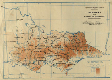 Federation University Historical Collection
Map, Victoria: Regions for Planning and Development, 1944, 1944
... Two colour map of Victoria showing the regions for planning... port phillip victoria m4486 Two colour map of Victoria showing ...This map was produced for the State Regional Boundaries Committee Two colour map of Victoria showing the regions for planning and development. The regions are Central Highlands, Mallee, Wimmera, Glenelg, Corangamite, Barwon, Loddon, Goulburn, Upper Goulburn, Upper Murray, East Gippsland, West Gippsland, Port Phillip.central highlands, mallee, wimmera, glenelg, corangamite, barwon, loddon, goulburn, upper goulburn, upper murray, east gippsland, west gippsland, port phillip, victoria, m4486 -
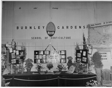 University of Melbourne, Burnley Campus Archives
Photograph - Black and white print, Royal Show 1957, 1957
... information and a map of Victoria locating institutes offering rural..., horticultural information and a map of Victoria locating institutes ...Note by T.H. Kneen 13 May1992, "The Burnley display was part of the Division of Agricultural Education's display covering Dookie, Longerenong and Burnley. Reference to Rural Training in 1957 would have been mainly to the on-farm training phase of the Rural Reconstruction Training Scheme. The Agricultural Collegians Association members had a meeting point at the exhibit. Burnley ex-students were not members of that association."Black and white photograph. Display mounted by Burnley Gardens School of Horticulture at the Royal Agricultural Show 1957. Incorporates photographs of College activities, horticultural information and a map of Victoria locating institutes offering rural training to ex-servicemen.On reverse, "Royal Show 1957."burnley gardens, school of horticulture, royal agricultural show, dookie college, rural training, rural reconstruction training scheme, the agricultural collegians association, horticulture, publicity, dept of agriculture education division, longerenong college -
 Numurkah & District Historical Society
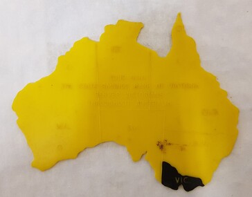
Equipment - Plastic stencil map/shape of Austalia
... marked on the map, Victoria painted in black... in the shape of Australia, states marked on the map, Victoria painted ...Yellow plastic stencil in the shape of Australia, states marked on the map, Victoria painted in blackState Savings Bank of Victoraeducation, school, geography, australia, stencil, drawing -
Glenelg Shire Council Cultural Collection
Souvenir - Limited Editions First Day Covers - Historic Shipwrecks - Admella 150 2009, 2009
... , with map Southern Victoria. 50 cents Admella Stamp not cancelled... cover. Both coloured envelope, with map Southern Victoria. 50 ...Limited edition first day cover. Both coloured envelope, with map Southern Victoria. 50 cents Admella Stamp not cancelled. 'Admella 150th Logo, 'Historic Shipwrecks' on front. back, short history of shipwrecks, Admella Lock Ard, Dunbar. -
Glenelg Shire Council Cultural Collection
Souvenir - First Day Cover, c. 1951
... . Buff envelope, green "CENTENARY OF VICTORIA' above green map... OF VICTORIA' above green map of Victoria, overlaid by scroll ...Envelope, First Day Cover, Centenary of Victoria 1851-1951. Buff envelope, green "CENTENARY OF VICTORIA' above green map of Victoria, overlaid by scroll with '1851-1951' either side of representation of Charles Joseph Latrobe, first Lt. Governor. -
 Vision Australia
Map - Object, Victorian railways map
... A black and white map of Victoria showing the railway lines...A black and white map of Victoria showing the railway lines ...A black and white map of Victoria showing the railway lines where mail is transported and the individual towns listed next to the dot that provides location of such. Underneath is written "Map of Victoria showing the localities beyond the suburbs of Melbourne to which library books are sent to blind members. Books are carried over the railways FREE there is no charge to the readers." Through the work of Tilly Aston, braille postage was provided free by the Victorian Railways which greatly assisted the Braille Library in reaching members who resided outside of Melbourne. This map was produced to show the extent of the work by the Victorian Association of Braille Writers and the need for reading materials across the state.Paper of Victorian railway lines mounted in framevictorian association of braille writers, marketing -
Glenelg Shire Council Cultural Collection
Souvenir - Tea Towel - Portland, Victoria, n.d
... . Printed with map of Victoria, with towns/cities, coloured... background. Printed with map of Victoria, with towns/cities, coloured ...Linen/cotton souvenir tea towel. Pale gold background. Printed with map of Victoria, with towns/cities, coloured depictions of hisitoric buildings in Victoria, including the Steam Packet Inn, Portland. "Historic Victoria' printed in black. Red border around tea towel.souvenir of portland, tea towel, domestic item -
Glenelg Shire Council Cultural Collection
Map, 1885
... Map, Victoria. Skeleton map of Telegraph Circuits... telegraph railways 1885 1880s Map, Victoria. Skeleton map ...Significant collection relating to the social history across the shire.Map, Victoria. Skeleton map of Telegraph Circuits and Railways 1885. Scale 16 miles to 1 inch.map, skeleton map, telegraph, railways, 1885, 1880s