Showing 2592 items
matching maps of victoria
-
 Stawell Historical Society Inc
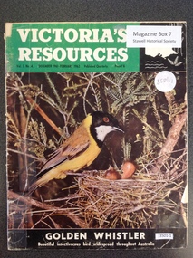
Book, Natural Resources Conservation, Victoria's Resources - Vol 3 No 4, 1962
... . Black section containing map of Victoria below a colour picture... with white & black print. Black section containing map of Victoria ...Departments, Regions, Municipalities and Organisations which are members of the Conservation League. These books were provided free of charge to residents.Paper cover: 3/4 Green strip with white & black print. Black section containing map of Victoria below a colour picture of a nesting mother bird with chicks below black strip with white printVictori's Resources Vol 3. No. 4. December 1961 February 1962. Published Quarterly Price 1'6 Golden Whistler Beautiful Insectivorous bird widespread thoughout Australiatourism -
 Vision Australia
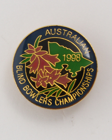
Badge - Object, Australian Blind Bowlers Championships 1988, 1988
... of the map of Victoria in green. Floral design in pink and green... circular badge with enamel front, back pin and part of the map ...Gold circular badge with enamel front, back pin and part of the map of Victoria in green. Floral design in pink and green on dark blue background with gold lettering.Gold enamel circular badge with gold writing and outline of Victoria and pink heath (state emblem)Australian Blind Bowlers Championships 1988recreation, badges -
 Glenelg Shire Council Cultural Collection
Map - Map - Western Victoria / South Australia, n.d
... Map - Western Victoria / South Australia...Black and white photographic copy of a map of Western... photographic copy of a map of Western Victoria and some of South ...Port of Portland Authority Archivesport of portland archives -
Tatura Irrigation & Wartime Camps Museum
Book, The Tatura Secret Radio, 1997
... . The front cover depicts a man with headphones on. A map of Victoria... with headphones on. A map of Victoria and short history of the book ...Army Intelligence knew there was a secret radio operating in Tatura No.1 Camp. The inmates were getting the war news direct from Germany. They had to have a strong shortwave receiver, but where was it?White soft cover book with an entrance made with barb wire. The front cover depicts a man with headphones on. A map of Victoria and short history of the book on the back cover. B/W photos, with a map of Tatura No 1 camp.Reg. No. 1870.1 signed "With Best Wishes Laura Nilsen"the tatura secret radio, nilsen h, nilsen l, glover i, camp 1, tatura, ww2 camp 1, books, history, local -
 Greensborough Historical Society
Map, Australia. Department of Minerals and Energy, Melbourne, topographic map, 1970_
... A topographic map of Victoria with Melbourne as the centre... Plenty Lower Plenty melbourne A topographic map of Victoria ...A topographic map of Victoria with Melbourne as the centre. Provisional edition showing contours in feet. International map of the world [scale] 1:1,000,000. Prepared by the Department of Minerals and Energy, Canberra in 1970.A pre-metric map, shows the Hume Highway travelling through towns such as Seymour and Benalla, now by-passed by the Hume Freeway.Map, printed in colour on one side.victoria - maps -
Glenelg Shire Council Cultural Collection
Souvenir - Drink Coasters, n.d
... , 'PORTLAND DEVELOPMENT COMMITTEE', map of Victoria, green and purple... COMMITTEE', map of Victoria, green and purple 'Prosper in Portland ...2 x Round, white cardboard coasters. Black line border, 'PORTLAND DEVELOPMENT COMMITTEE', map of Victoria, green and purple 'Prosper in Portland' overlaid. Identification Numbers 6349, 6349 a Measures each 9.3 cm diameter -
 Federation University Historical Collection
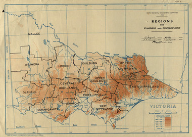
Map, Victoria: Regions for Planning and Development, 1944, 1944
... Two colour map of Victoria showing the regions for planning... port phillip victoria m4486 Two colour map of Victoria showing ...This map was produced for the State Regional Boundaries Committee Two colour map of Victoria showing the regions for planning and development. The regions are Central Highlands, Mallee, Wimmera, Glenelg, Corangamite, Barwon, Loddon, Goulburn, Upper Goulburn, Upper Murray, East Gippsland, West Gippsland, Port Phillip.central highlands, mallee, wimmera, glenelg, corangamite, barwon, loddon, goulburn, upper goulburn, upper murray, east gippsland, west gippsland, port phillip, victoria, m4486 -
 University of Melbourne, Burnley Campus Archives
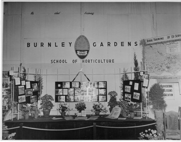
Photograph - Black and white print, Royal Show 1957, 1957
... information and a map of Victoria locating institutes offering rural..., horticultural information and a map of Victoria locating institutes ...Note by T.H. Kneen 13 May1992, "The Burnley display was part of the Division of Agricultural Education's display covering Dookie, Longerenong and Burnley. Reference to Rural Training in 1957 would have been mainly to the on-farm training phase of the Rural Reconstruction Training Scheme. The Agricultural Collegians Association members had a meeting point at the exhibit. Burnley ex-students were not members of that association."Black and white photograph. Display mounted by Burnley Gardens School of Horticulture at the Royal Agricultural Show 1957. Incorporates photographs of College activities, horticultural information and a map of Victoria locating institutes offering rural training to ex-servicemen.On reverse, "Royal Show 1957."burnley gardens, school of horticulture, royal agricultural show, dookie college, rural training, rural reconstruction training scheme, the agricultural collegians association, horticulture, publicity, dept of agriculture education division, longerenong college -
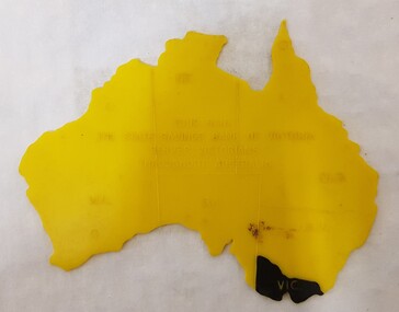 Numurkah & District Historical Society
Equipment - Plastic stencil map/shape of Austalia
... marked on the map, Victoria painted in black... in the shape of Australia, states marked on the map, Victoria painted ...Yellow plastic stencil in the shape of Australia, states marked on the map, Victoria painted in blackState Savings Bank of Victoraeducation, school, geography, australia, stencil, drawing -
Glenelg Shire Council Cultural Collection
Souvenir - Limited Editions First Day Covers - Historic Shipwrecks - Admella 150 2009, 2009
... , with map Southern Victoria. 50 cents Admella Stamp not cancelled... cover. Both coloured envelope, with map Southern Victoria. 50 ...Limited edition first day cover. Both coloured envelope, with map Southern Victoria. 50 cents Admella Stamp not cancelled. 'Admella 150th Logo, 'Historic Shipwrecks' on front. back, short history of shipwrecks, Admella Lock Ard, Dunbar. -
Glenelg Shire Council Cultural Collection
Souvenir - First Day Cover, c. 1951
... . Buff envelope, green "CENTENARY OF VICTORIA' above green map... OF VICTORIA' above green map of Victoria, overlaid by scroll ...Envelope, First Day Cover, Centenary of Victoria 1851-1951. Buff envelope, green "CENTENARY OF VICTORIA' above green map of Victoria, overlaid by scroll with '1851-1951' either side of representation of Charles Joseph Latrobe, first Lt. Governor. -
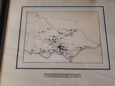 Vision Australia
Map - Object, Victorian railways map
... A black and white map of Victoria showing the railway lines...A black and white map of Victoria showing the railway lines ...A black and white map of Victoria showing the railway lines where mail is transported and the individual towns listed next to the dot that provides location of such. Underneath is written "Map of Victoria showing the localities beyond the suburbs of Melbourne to which library books are sent to blind members. Books are carried over the railways FREE there is no charge to the readers." Through the work of Tilly Aston, braille postage was provided free by the Victorian Railways which greatly assisted the Braille Library in reaching members who resided outside of Melbourne. This map was produced to show the extent of the work by the Victorian Association of Braille Writers and the need for reading materials across the state.Paper of Victorian railway lines mounted in framevictorian association of braille writers, marketing -
Glenelg Shire Council Cultural Collection
Souvenir - Tea Towel - Portland, Victoria, n.d
... . Printed with map of Victoria, with towns/cities, coloured... background. Printed with map of Victoria, with towns/cities, coloured ...Linen/cotton souvenir tea towel. Pale gold background. Printed with map of Victoria, with towns/cities, coloured depictions of hisitoric buildings in Victoria, including the Steam Packet Inn, Portland. "Historic Victoria' printed in black. Red border around tea towel.souvenir of portland, tea towel, domestic item -
Glenelg Shire Council Cultural Collection
Map, 1885
... Map, Victoria. Skeleton map of Telegraph Circuits... telegraph railways 1885 1880s Map, Victoria. Skeleton map ...Significant collection relating to the social history across the shire.Map, Victoria. Skeleton map of Telegraph Circuits and Railways 1885. Scale 16 miles to 1 inch.map, skeleton map, telegraph, railways, 1885, 1880s -
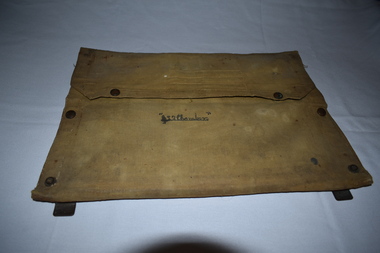 Dandenong/Cranbourne RSL Sub Branch
Functional object - Canvas document satchel
... maps of Gembrook ( Victoria ) and Shoalwater Bay ( Queensland ).... document folder with metal frame. Contents include maps ...Canvas document folder with metal frame. Contents include maps of Gembrook ( Victoria ) and Shoalwater Bay ( Queensland ).Name inscribed on front " L . Chambers." -
Lakes Entrance Historical Society
Book, Commonwealth Forests Taskforce, Regional 1999 Assessment Report for Forest Agreement, 1999
... the forest agreement process containing many maps in Gippsland... to support the forest agreement process containing many maps ...Comprehensive report prepared by officials to support the forest agreement process containing many maps in Gippsland Victoriaforest, heritage -
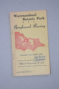 Warrnambool and District Historical Society Inc.
Programme, Gaspars Modern Printing Co, Greyhound Racing, 1975
... and a map of Victoria. The programme has been stapled... printing and an image in red of a greyhound and a map of Victoria ...This is a programme of a greyhound racing meeting held in Warrnambool in August 1975. The meeting was held in Botanic Park, in Botanic Road Warrnambool opposite the Warrnambool Botanic Gardens. Today greyhound racing meetings in Warrnambool are held in Koroit Street on a track in the Warrnambool Showgrounds and the Botanic Road site is now the location of a Catholic Primary School. This programme is retained as a memento of the 1970s when the Warrnambool Greyhound Racing Club meetings were held in a park in Botanic Road, Warrnambool. This is a soft cover booklet of 16 pages. The cover is yellow with black printing and an image in red of a greyhound and a map of Victoria. The programme has been stapled but the staples have been removed. The pages and front cover of the programme have been marked with black biro and red crayon.‘Warrnambool Botanic Park Greyhound Racing Thursday 21st August 1975’warrnambool greyhound racing, history of warrnambool -
Creswick Campus Historical Collection - University of Melbourne
Map, 1937-1942
... Linen backed topographical Maps - Victoria. 26 folding maps... - Victoria. 26 folding maps School of Botany, Univerity of Melbourne ...Linen backed topographical Maps - Victoria. 26 folding mapsMapsSchool of Botany, Univerity of Melbourne -
Creswick Campus Historical Collection - University of Melbourne
Map, 1937-1942
... Linen backed topographical Maps - Victoria. 21 folding maps... - Victoria. 21 folding maps School of Botany, Univerity of Melbourne ...Linen backed topographical Maps - Victoria. 21 folding mapsMapsSchool of Botany, Univerity of Melbourne -
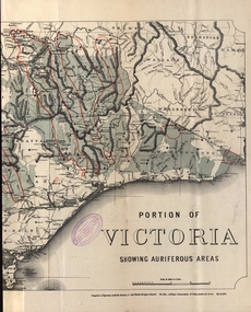 Federation University Historical Collection
Map - Map and Information, Department of Mines: Map and Suggestions to Prospectors, 1891
... map of victoria...Document: 4 page type written Map: Portion of Victoria... in 1894 gold auriferous areas department of mines victoria map ...The map outlines the auriferous (gold bearing) areas in Victoria. The information for prospectors was prepared by the Department of Mines in 1894Document: 4 page type written Map: Portion of Victoria divided into Counties of 1891. Auriferous areas with red.Reference section on mapgold, auriferous areas, department of mines, victoria, map of victoria, prospectors, commissioner of crown lands, hon a mclean, alexander black, surveyor general, a mclean -
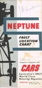 Bendigo Historical Society Inc.
Map - J W SWATTON COLLECTION: MAPS
... , Victoria, Road Condition Map of Victoria including Melbourne-Cairns... of the City of Ballarat, Victoria, Road Condition Map of Victoria ...Seven maps of various sizes. Map of the City of Ballarat, Victoria, Road Condition Map of Victoria including Melbourne-Cairns & Melbourne-Adelaide, Neptune Fault Location Chart, Grampians District Map, Racv Tour Planning Map Showing Road Conditions for Victoria, NSW and Queensland and Mt Macedon & District. Two of the maps have J W swatton & J Swatton written on them.j w swatton collection, racv, mobil, neptune, a r blair, j ewins & sons pty ltd, berry anderson & co -
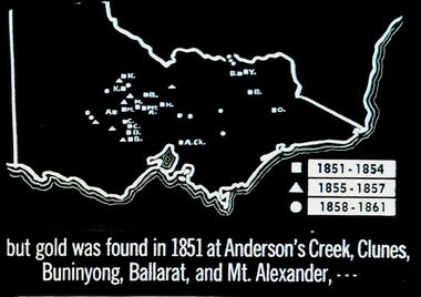 Bendigo Historical Society Inc.
Slide - DIGGERS & MINING. THE GOLD ERA, c1851
... , - - - Slide shows map of Victoria with legend to show when gold... map of Victoria with legend to show when gold was found ...BHS CollectionDiggers & mining. But gold was found in 1851 at Anderson's Creek, Clunes, Buninyong, Ballarat, and Mt. Alexander, - - - Slide shows map of Victoria with legend to show when gold was found in different areas. The gold era. Markings 4 994.031 GOL:5. Used as a teaching aid. Used as a teaching aid.hanimounteducation, tertiary, goldfields -
 St Kilda Historical Society
Photograph - Photo map, 28/01/1951
... with a current map, and access to other historical photo maps of Victoria... maps of Victoria, see the Historic Photo-Maps Index published ...One of a series of photo-maps produced for the Department of Crown Lands and Survey (1857-1983). For correlation with a current map, and access to other historical photo maps of Victoria, see the Historic Photo-Maps Index published by the Department of Environment, Land, Water and Planning at https://services.land.vic.gov.au/DELWPmaps/historical-photomaps/Black and white aerial photograph1424-45 SECRET 534 Run 18 Lens 12" Melbourne Metropolitan 12150 28.1.51 M639albert park, st kilda junction, st kilda pier, catani gardens, st kilda, prahran, albert park lake, 1951, middle park, st kilda beach, windsor -
 St Kilda Historical Society
Photograph - Photo map, 17/01/1951
... with a current map, and access to other historical photo maps of Victoria... maps of Victoria, see the Historic Photo-Maps Index published ...One of a series of photo-maps produced for the Department of Crown Lands and Survey (1857-1983). For correlation with a current map, and access to other historical photo maps of Victoria, see the Historic Photo-Maps Index published by the Department of Environment, Land, Water and Planning at https://services.land.vic.gov.au/DELWPmaps/historical-photomaps/Black and white aerial photograph1414-21 538 Run 19 Lens 12" Melbourne Metropolitan 12150 17.1.51 M586st kilda, st kilda botanical gardens, peanut farm, elwood, 1951, point ormond, elwood canal, st kilda beach -
 St Kilda Historical Society
Photograph - Photo map, 28/01/1951
... with a current map, and access to other historical photo maps of Victoria... maps of Victoria, see the Historic Photo-Maps Index published ...One of a series of photo-maps produced for the Department of Crown Lands and Survey (1857-1983). For correlation with a current map, and access to other historical photo maps of Victoria, see the Historic Photo-Maps Index published by the Department of Environment, Land, Water and Planning at https://services.land.vic.gov.au/DELWPmaps/historical-photomaps/Black and white aerial photograph1424-118 534 Run 20 Lens 12" Melbourne Metropolitan 12150 18.1.51M639elwood, point ormond, elwood park, elsternwick park, elwood beach, 1951 -
 St Kilda Historical Society
Photograph - Photo map, 17/01/1951
... with a current map, and access to other historical photo maps of Victoria... maps of Victoria, see the Historic Photo-Maps Index published ...One of a series of photo-maps produced for the Department of Crown Lands and Survey (1857-1983). For correlation with a current map, and access to other historical photo maps of Victoria, see the Historic Photo-Maps Index published by the Department of Environment, Land, Water and Planning at https://services.land.vic.gov.au/DELWPmaps/historical-photomaps/Black and white aerial photograph1414-20 538 Run 19 Lens 12" Melbourne Metropolitan 12150 17.1.51 M586elwood, elsternwick, st kilda east, balaclava, ripponlea, 1951 -
 St Kilda Historical Society
Photograph - Photo map, 28/01/1951
... with a current map, and access to other historical photo maps of Victoria... maps of Victoria, see the Historic Photo-Maps Index published ...One of a series of photo-maps produced for the Department of Crown Lands and Survey (1857-1983). For correlation with a current map, and access to other historical photo maps of Victoria, see the Historic Photo-Maps Index published by the Department of Environment, Land, Water and Planning at https://services.land.vic.gov.au/DELWPmaps/historical-photomaps/Black and white aerial photograph1424-44 534 Run 18 Lens 12" Melbourne Metropolitan 12150 28.1.51 M639 -
 St Kilda Historical Society
Photograph - Photo map, 28/01/1951
... with a current map, and access to other historical photo maps of Victoria... maps of Victoria, see the Historic Photo-Maps Index published ...One of a series of photo-maps produced for the Department of Crown Lands and Survey (1857-1983). For correlation with a current map, and access to other historical photo maps of Victoria, see the Historic Photo-Maps Index published by the Department of Environment, Land, Water and Planning at https://services.land.vic.gov.au/DELWPmaps/historical-photomaps/Black and white aerial photograph1424-43 534 Run 18 Lens 12" Melbourne Metropolitan 12150 28.1.51 M639armadale, malvern, st kilda cemetery, caulfield north, st kilda east, 1951 -
 St Kilda Historical Society
Photograph - Photo map, 30/01/1960
... with a current map, and access to other historical photo maps of Victoria... maps of Victoria, see the Historic Photo-Maps Index published ...One of a series of photo-maps produced for the Department of Crown Lands and Survey (1857-1983). For correlation with a current map, and access to other historical photo maps of Victoria, see the Historic Photo-Maps Index published by the Department of Environment, Land, Water and Planning at https://services.land.vic.gov.au/DELWPmaps/historical-photomaps/Black and white aerial photographVic 1093-62 Melbourne & Metropolitan Project Run 21 30.1.60 Lens 10" 8.200middle park, albert park, catani gardens, st kilda west, 1960 -
 St Kilda Historical Society
Photograph - Photo map, 30/01/1960
... with a current map, and access to other historical photo maps of Victoria... maps of Victoria, see the Historic Photo-Maps Index published ...One of a series of photo-maps produced for the Department of Crown Lands and Survey (1857-1983). For correlation with a current map, and access to other historical photo maps of Victoria, see the Historic Photo-Maps Index published by the Department of Environment, Land, Water and Planning at https://services.land.vic.gov.au/DELWPmaps/historical-photomaps/Black and white aerial photographVic 1093-60 Melbourne & Metropolitan Project Run 21 30.1.60 Lens 10" 8.200st kilda, albert park, prahran, windsor, south yarra, 1960