Showing 70984 items
matching melbourne street
-
 Ringwood and District Historical Society
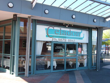
Photograph, Corner of Civic Place and Melbourne Street, Ringwood in 2008, showing Celadon Thai restaurant
... Corner of Civic Place and Melbourne Street, Ringwood in... Haines, RDHS, in 2008. Corner of Civic Place and Melbourne Street ...Photographic record by Russ Haines, RDHS, in 2008. -
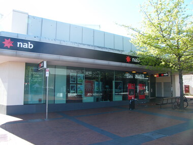
 Ringwood and District Historical Society
Photograph, Corner of Civic Place and Melbourne Street, Ringwood in 2008, showing NAB Bank
... Corner of Civic Place and Melbourne Street, Ringwood in... Haines, RDHS, in 2008. Corner of Civic Place and Melbourne Street ...Photographic record by Russ Haines, RDHS, in 2008. -
 Ringwood and District Historical Society
Photograph, Corner of Civic Place and Melbourne Street, Ringwood in 2008
... Corner of Civic Place and Melbourne Street, Ringwood in... Haines, RDHS, in 2008. Corner of Civic Place and Melbourne Street ...Photographic record by Russ Haines, RDHS, in 2008. -
 Ringwood and District Historical Society
Photograph, Steps down from Melbourne Street, Ringwood to Eastland entrance in 2008
... Steps down from Melbourne Street, Ringwood to Eastland... Haines, RDHS, in 2008. Steps down from Melbourne Street, Ringwood ...Photographic record by Russ Haines, RDHS, in 2008. -
 Ringwood and District Historical Society
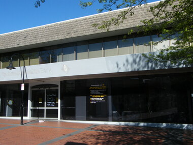
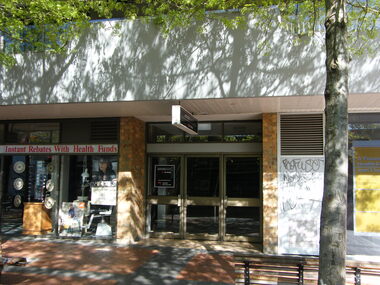
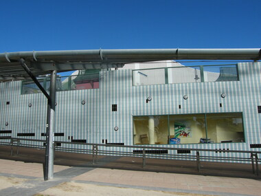
Photograph, Former Commonwealth Bank at the corner of Civic Place and Melbourne Street, Ringwood in 2008
... Melbourne Street, Ringwood in 2008.... of Civic Place and Melbourne Street, Ringwood in 2008. Photograph ...Photographic record by Russ Haines, RDHS, in 2008. -
 Ringwood and District Historical Society
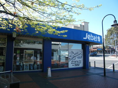
Photograph, Former Commonwealth Bank on Melbourne Street, Ringwood in 2008. Includes other businesses and opens up to Maroondah Highway
... Former Commonwealth Bank on Melbourne Street, Ringwood in... Road Ringwood North melbourne Photographic record by Russ ...Photographic record by Russ Haines, RDHS, in 2008. -
 Ringwood and District Historical Society
Photograph, East side of Melbourne Street, Ringwood in 2008, opens up to Maroondah Highway with Railway Station over the road
... East side of Melbourne Street, Ringwood in 2008, opens up... Haines, RDHS, in 2008. East side of Melbourne Street, Ringwood ...Photographic record by Russ Haines, RDHS, in 2008. -
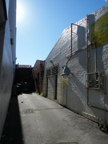
 Ringwood and District Historical Society
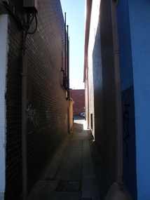
Photograph, Laneway on east side of Melbourne Street, Ringwood in 2008
... Laneway on east side of Melbourne Street, Ringwood in 2008.... Haines, RDHS, in 2008. Laneway on east side of Melbourne Street ...Photographic record by Russ Haines, RDHS, in 2008. -
 Ringwood and District Historical Society
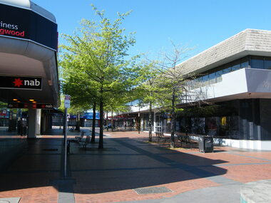
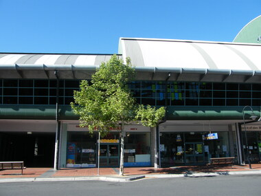
Photograph, West side of Melbourne Street, Ringwood in 2008
... West side of Melbourne Street, Ringwood in 2008.... Haines, RDHS, in 2008. West side of Melbourne Street, Ringwood ...Photographic record by Russ Haines, RDHS, in 2008. -
 Ringwood and District Historical Society
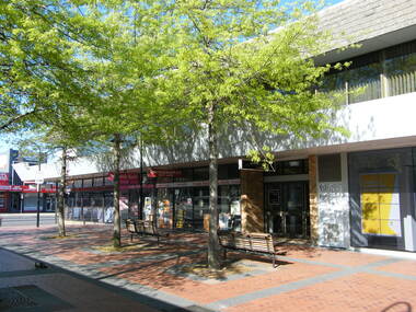
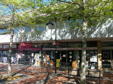
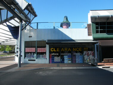
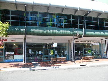
Photograph, West side of Melbourne Street, Ringwood in 2008, with various businesses
... West side of Melbourne Street, Ringwood in 2008, with... Haines, RDHS, in 2008. West side of Melbourne Street, Ringwood ...Photographic record by Russ Haines, RDHS, in 2008. -
 Ringwood and District Historical Society
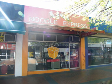
Photograph, East side of Melbourne Street, Ringwood in 2008, showing Noodle Express at no. 19
... East side of Melbourne Street, Ringwood in 2008, showing... Haines, RDHS, in 2008. East side of Melbourne Street, Ringwood ...Photographic record by Russ Haines, RDHS, in 2008. -
 Ringwood and District Historical Society
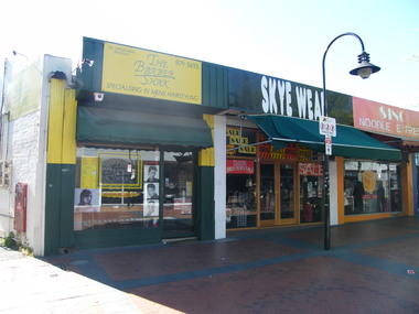
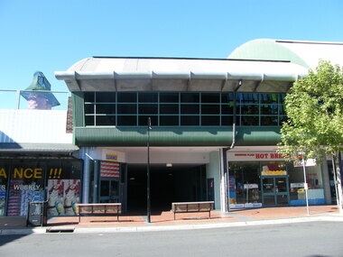
Photograph, East side of Melbourne Street, Ringwood in 2008, showing The Barber Shack and Skye Wear shops
... East side of Melbourne Street, Ringwood in 2008, showing... Haines, RDHS, in 2008. East side of Melbourne Street, Ringwood ...Photographic record by Russ Haines, RDHS, in 2008. -
 Ringwood and District Historical Society
Photograph, Laneway at east side of Melbourne Street, Ringwood in 2008, next to The Barber Shack
... Laneway at east side of Melbourne Street, Ringwood in 2008... Haines, RDHS, in 2008. Laneway at east side of Melbourne Street ...Photographic record by Russ Haines, RDHS, in 2008. -
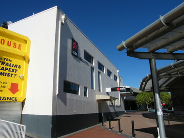
 Ringwood and District Historical Society
Photograph, Melbourne Street, Ringwood in 2008, showing NAB Bank
... Melbourne Street, Ringwood in 2008, showing NAB Bank.... Haines, RDHS, in 2008. Melbourne Street, Ringwood in 2008 ...Photographic record by Russ Haines, RDHS, in 2008. -
 Ringwood and District Historical Society
Photograph, Melbourne Street, east over to Adealide Street, Ringwood in 2008, showing NAB Bank, rear of Chemist Warehouse and Maroondah Credit Union
... Melbourne Street, east over to Adealide Street, Ringwood in... Haines, RDHS, in 2008. Melbourne Street, east over to Adealide ...Photographic record by Russ Haines, RDHS, in 2008. -
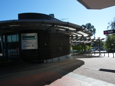 Ringwood and District Historical Society
Photograph, Walkway down from Melbourne Street, over to Eastland, Ringwood in 2008, showing NAB Bank
... Walkway down from Melbourne Street, over to Eastland... Haines, RDHS, in 2008. Walkway down from Melbourne Street, over ...Photographic record by Russ Haines, RDHS, in 2008. -
 Ringwood and District Historical Society
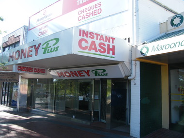
Photograph, Civic Mall joining from Melbourne Street over to former Adelaide Street, Ringwood in 2008, showing Money Plus
... Civic Mall joining from Melbourne Street over to former... Haines, RDHS, in 2008. Civic Mall joining from Melbourne Street ...Photographic record by Russ Haines, RDHS, in 2008. -
 Ringwood and District Historical Society
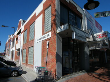
Photograph, Civic Mall joining from Melbourne Street over to former Adelaide Street, Ringwood in 2008, showing Jan Kronberg MP office
... Civic Mall joining from Melbourne Street over to former... Haines, RDHS, in 2008. Civic Mall joining from Melbourne Street ...Photographic record by Russ Haines, RDHS, in 2008. -
 Ringwood and District Historical Society
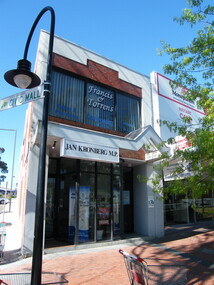
Photograph, Civic Mall joining from Melbourne Street over to former Adelaide Street, Ringwood in 2008, showing Jan Kronberg MP office and Frances and Torrens Conveyancing
... Civic Mall joining from Melbourne Street over to former... Haines, RDHS, in 2008. Civic Mall joining from Melbourne Street ...Photographic record by Russ Haines, RDHS, in 2008. -
 Ringwood and District Historical Society
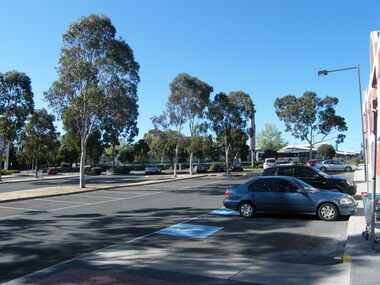
Photograph, End of Civic Mall joining from Melbourne Street over to former Adelaide Street, Ringwood in 2008, used for car parking
... End of Civic Mall joining from Melbourne Street over to... Road Ringwood North melbourne Photographic record by Russ ...Photographic record by Russ Haines, RDHS, in 2008. -
 Ringwood and District Historical Society
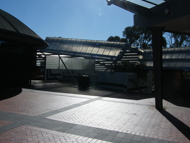
Photograph, Walkway from Melbourne Street to entrance of Eastland, Ringwood in 2008
... Walkway from Melbourne Street to entrance of Eastland... Haines, RDHS, in 2008. Walkway from Melbourne Street to entrance ...Photographic record by Russ Haines, RDHS, in 2008. -
 Ringwood and District Historical Society
Photograph, Walkway from Melbourne Street to entrance of Eastland, Ringwood in 2008, showing shops
... Walkway from Melbourne Street to entrance of Eastland... Haines, RDHS, in 2008. Walkway from Melbourne Street to entrance ...Photographic record by Russ Haines, RDHS, in 2008. -
 Ringwood and District Historical Society
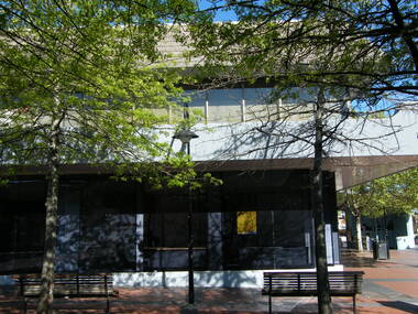
Photograph, Below Melbourne Street to entrance of Eastland, Ringwood in 2008, showing shops at Ringwood Plaza
... Below Melbourne Street to entrance of Eastland, Ringwood in... Haines, RDHS, in 2008. Below Melbourne Street to entrance ...Photographic record by Russ Haines, RDHS, in 2008. -
 Ringwood and District Historical Society
Photograph, Below Melbourne Street to entrance of Eastland, Ringwood in 2008, showing shops at Ringwood Plaza and Ringwood Library above
... Below Melbourne Street to entrance of Eastland, Ringwood in... Haines, RDHS, in 2008. Below Melbourne Street to entrance ...Photographic record by Russ Haines, RDHS, in 2008. -
 Ringwood and District Historical Society
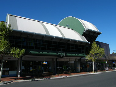
Photograph, Entrance to Melbourne Street, Ringwood
... Entrance to Melbourne Street, Ringwood... Haines, RDHS, in October 2008. Entrance to Melbourne Street ...Photographic record by Russ Haines, RDHS, in October 2008. -
 Ringwood and District Historical Society
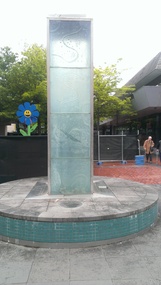
Photograph, Water feature in Melbourne Street, Ringwood. Contruction work beginning at the Ringwood Railway Station and Stage 5 of Eastland circa 2014
... Water feature in Melbourne Street, Ringwood. Contruction... in 2008-2014, member of RDHS Water feature in Melbourne Street ...Photographs taken by Terry Ahern in 2008-2014, member of RDHS -
 Ringwood and District Historical Society
Photograph, Former shops to the east of Melbourne Street in January 2008. Knocked down in later preparation for construction work beginning at the Ringwood Railway Station and Stage 5 of Eastland circa 2014
... Former shops to the east of Melbourne Street in January... Road Ringwood North melbourne Photographs taken by Terry Ahern ...Photographs taken by Terry Ahern in 2008-2014, member of RDHS -
 Ringwood and District Historical Society
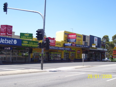
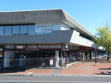
Photograph - Multiple, Corner of 147 Maroondah Highway and Melbourne Street, Ringwood in 2008. Formerly the Commonwealth Bank, Burdines, Janome, Activate Church and Electoral Office. Buildings bought by QIC in 2000, 2008
... Corner of 147 Maroondah Highway and Melbourne Street... Maroondah Highway and Melbourne Street, Ringwood in 2008. Formerly ...Before Stage 5 of the expansion of Eastland and REALM.Digital photographs only