Showing 99 items
matching mernda road
-
 Greensborough Historical Society
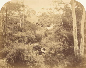
Photograph (copy), Willis's Mill, 1855c
Photograph of ruins of early flour mill on Plenty River.http://www.mintinc.com.au/pdf/carome_mill_arch_report.pdf Detailed report on same.A photocopy of a photograph of Willis's Flour Mill located on the Plenty River behind Carome Station Mernda.Nilplenty river, flour mill, mernda, yan yean reservoir, riparian rights, 1840, fred kruger, williss mill -
 Greensborough Historical Society
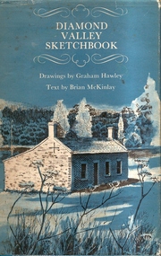
Book, Diamond Valley Sketchbook, 1973_
Diamond Valley Sketchbook, written by Brian McKinlay with drawings by Graham Hawley. Cover the area surrounding the Diamond Valley from Heidelberg to Mernda.A sketch book featuring landmarks around the Diamond Valley area in 1973. Many of these no longer exist.A 63 page hard back book with a map of the area covered by the book printed in blue in the inner covers. Three copies have a dust jacket printed in blue with title details, whilst the actual book cover lacks any detail. 4 copies.Some pencil markings in the inside cover.diamond valley, griffin house, rosehill, austin hospital, banyule house, trestle bridge eltham, shillinglaw cottage, montsalvat, old england hotel, eltham primary school, sweeney's cottage, pound bend tunnel, weller's pub, the eltham barrel, hassall's gallery, st katherine's chapel, yan yean reservoir, mernda hotel -
 Greensborough Historical Society
Newspaper Clipping, Diamond Valley News, Station at breaking point, 11/12/2019
Frustrated Mernda commuters have inundated the Hurstbridge line, packing into peak hour services and filling the Watsonia station carpark "like never before".News article 1 page, black text, colour image.hurstbridge line, watsonia station, mernda commuters, hurstbridge line upgrade -
 Greensborough Historical Society
Map, Melbourne and Metropolitan Board of Works. Survey Division, MMBW, Yarra 2500 / 13.28. Mernda, Wilton Vale, 1977_08
Melbourne and Metropolitan Board of Works. Yarra 2500 [base map] 13.28. Mernda, Wilton Vale. Municipality of Diamond Valley 257 and Whittlesea 239. Prominent streets: Wilton Vale Road. Features include Yan Yean Pipe Track and SEC Transmission Lines. The abandoned rail line (old Whittlesea line) is in the top left corner.MMBW Map in 1:2500 [scale] series. Cream parchment with green tape reinforcing on edges and punched holes on left edge.mmbw, melbourne and metropolitan board of works, shire of diamond valley, mernda - maps -
 Greensborough Historical Society
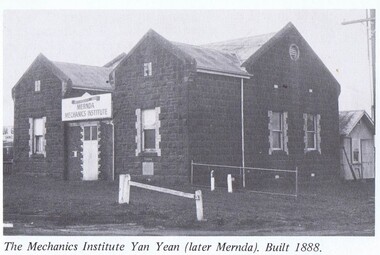
Photograph - Photograph (Copy), Dianne Edwards, The Mechanics Institute Yan Yean (later Mernda), 1978
The Mechanics Institute, Yan Yean (later Mernda) was built in 18881 p. black and white photocopy from bookyan yean, mernda, mechanics institutes victoria -
 Greensborough Historical Society
Article - Article, Book, Dianne Edwards, Turner Brothers Bakery, 1978
Account of Turner Brothers bakery, built in the 1880s on the Plenty Road at South Yan Yean (now Mernda)1 p. text and photographyan yean, mernda, turners bakery, turner family -
 Greensborough Historical Society
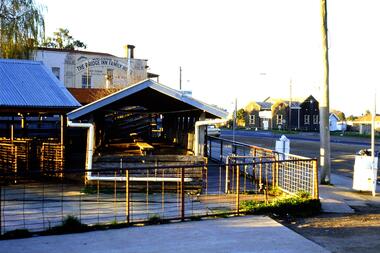
Slide - Photograph, John Ramsdale, Slide 43
Photograph shows Bridge Inn Hotel Mernda and Mernda Mechanics InstitutePart of the John Ramsdale collection of slides and audio visual material.Colour photograph scanned from slide.No maker's marks. No caption on slide. -
 Greensborough Historical Society
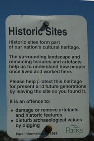
Photograph - Digital Image, Mernda historic sites 2018, 25/07/2019
In 2018 GHS members visited Turner's Bakery in Mernda for lunch and continued on to visit historic sites remaining in the Mernda area. These photographs show remnant bush and the Parks Victoria sign in the area.Mernda is an area of rapid modern growth with a few remaining historic buildings dating from the 19th centuryDigital copy of colour photographsmernda, parks victoria, bushland -
 Greensborough Historical Society
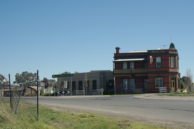
Photograph - Digital Image, Bridge Inn Hotel Mernda 2018, 25/07/2019
In 2018 GHS members visited Turner's Bakery in Mernda for lunch and continued on to visit historic sites remaining in the Mernda area. This photograph shows the Bridge Inn Hotel Mernda, established 1891. The hotel is still operating in the 21st century.Mernda is an area of rapid modern growth with a few remaining historic buildings dating from the 19th century.Digital copy of colour photographmernda, bridge inn hotel mernda, mernda historic sites, hotels mernda -
 Greensborough Historical Society
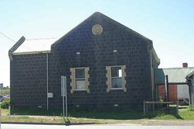
Photograph - Digital Image, Marilyn Smith, Mernda Mechanics Institute 2018, 27/09/2018
In 2018 GHS members visited Turner's Bakery in Mernda for lunch and continued on to visit historic sites remaining in the Mernda area. This photograph shows the Mernda Mechanics Institute, established 1888. It was sited to the rear of the Bridge Inn Hotel on land donated by the hotel's owner. Today the Mechanic's institute is a small hall available to rent.Mernda is an area of rapid modern growth with a few remaining historic buildings dating from the 19th century.Digital copy of colour photographsmernda, mernda historic sites, mernda mechanics institute, mechanics institutes victoria, bridge inn hotel mernda -
 Greensborough Historical Society
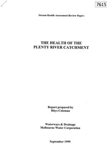
Document - Report, Rhys Coleman, The Health of the Plenty River Catchment 1999, 1999_09
Report prepared by Rhys Coleman for Waterways and Drainage, Melbourne Water Corporation, discusses the health of the Plenty River catchment from upstream of Toorourrong Reservoir, through Whittlesea and Mernda, South Morang and Plenty to Greensborough and confluence with the Yarra River.31 p., tables.plenty river, melbourne water corporation -
 Friends of Westgarthtown
Painting, John Borrack, Last Days Ziebells "The Pines" Thomastown
Painted from the home (or front) paddock which ran south to the creek. The paddock was used for the cultivation of lucerne and maize crops in the lower regions while closer to the house where Ainwick Crescent is now situated, it was a burgeoning market garden for the cultivation of all varieties of vegetables. The large pines beyond, sheltered the farmyard on the west of Gardenia Road. That complex can be partly glimpsed on the left of the painting. This is a directly painted watercolour relying on the use of white paper and transparencies to impart a feeling of morning light. The figure is the artist's mother for whom the picture was painted. Provenance: Augusta Borrack (nee Ziebell) Collection, John Borrack CollectionWatercolour painting, depicting Ziebell's Farmhouse from the south (Thomastown and Mernda). Painting is mounted in a gold frame with cream board.Artist signature: John Borrack; Last Days at Ziebells "The Pines" Thomastown, 'Pro mea matre hanc picturan feci (In Memoria)'illustrations, watercolours, john borrack, ziebell, watercolour, painting -
 Friends of Westgarthtown
Painting, John Borrack, Ziebells, German Lane, South View
Painted from Gardenia Road. The extensive farm complex on the right. (Western side of Gardenia Road). was demolished in 1972 for housing development. Buildings shown are cowshed, hay barn, engine shed and stables. Painted in the late afternoon, the lengthening shadows and lowering sky, could presage the ominous fate awaiting the farm with development. The Ziebell Farm was known as “The Pines†and sadly none of the many that proliferated there remain. Today they would be equivalent to those at the cemetery, having been planted at the same time. Provenance: John Borrack CollectionWatercolour depicting Ziebell Farmhouse from the north, Thomastown and Mernda. In gold frame with cream border.Artist signature: John Borrack; 70's Ziebells German Lane South Viewillustrations, watercolours, john borrack, ziebell, watercolour, painting -
 Greensborough Historical Society
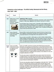
Article, Anne Paul, Footprints on the landscape, by Anne Paul, 2018 and 2022
Covers the period from migration of the Willis family to Van Diemen's Land in 1823, later to squatting on the Plenty River area in 1837 at Lower Plenty and Mernda and afterwards in the Western District4 p., text and col. photographs. Also, later version August 2022.willis family, plenty river, lower plenty -
 Eltham District Historical Society Inc
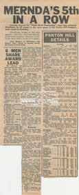
Newspaper clipping, Mernda's 5th in a row and Panton Hill Details, Diamond Valley News, c.1970, 1970c
Panton Hill Football League match results On reverse of clipping is an article "Old document gift to Shire" (partially cut off) is about the presentation of a portrait of C.S. Wingrove and an illuminated address presented to Mr Wingrove prepared in 1868 by the Eltham District Road Board. Digital file only - scanned by EDHS from item on loanc.s.wingrove, charles symons wingrove, eltham district road board, lew howard collection, match details, panton hill football league, shire of eltham -
 City of Whittlesea
Badge - Badges - Advocacy Campaign, Access Denied, 2014
Access Denied was a joint advocacy campaign between the City of Whittlesea and the local community in the lead up to the 2014 Victorian State Election. The campaign called on all political parties to commit to extending the railway line from South Morang to Mernda and building access ramps on the Hume Freeway at O’Herns Road in Epping North. The campaign was a success and secured almost $650 million in promises from the incoming Labor Government to build these projects. Badge, metal back with pin, white plastic printed front, black and red textConnect O'Herns Road / Access Denied / Get on Board / www.accessdenied.net.au / Build Mernda Railbadges, campaign badges, south morang railway, mernda railway -
 City of Whittlesea
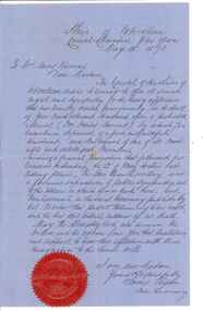
Document - Correspondence, Council letter to Mrs Moses Thomas 1868, 1878
In 1851 Moses Thomas purchased 400 acres, including a half mile frontage to the Plenty River, at Mernda (then known as Morang) where he operated a farm, inn and other business. In 1865 Moses Thomas was appointed Engineer, Clerk and Collector for the Morang District Road Board. In this role he would have been responsible for overseeing the collection of local property rates and the maintenance and construction of local roads and drains. Road District Boards were one of the earliest forms of local government in Victoria. The Morang or Upper Plenty Road District was established in 1862. It covered part of what is today Mernda, Doreen, South Morang, Mill Park and Bundoora. In 1875, the area merged with the Whittlesea Road District to form the Shire of Whittlesea. Moses Thomas briefly served as a Councillor with the Shire of Whittlesea until his death in 1878. Correspondence. Letter, paper, handwritten text with seal. Letter from James Ryan, Shire Secretary, Shire of Whittlesea to Mrs Moses Thomas on the death of Moses 18 May 1878. -
 Whittlesea Historical Society Inc.
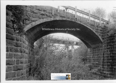
Photograph, Matt Dickinson, Monier Bridge over the Darebin Creek Wollert, 2001
Photographs of the Monier Bridge over the Darebin Creek on Bridge Inn Road at Wollert with the new bridge in the background.Listed on The National Trust Heritage Register and associated with Sir John Monash.2 Black and white photographs.M. Dickinson handwritten on the backmernda, wollert, monier bridge, bluestone bridge, sir john monash, bridge inn road, arch bridge, concrete reinforced bridge -
 Whittlesea Historical Society Inc.
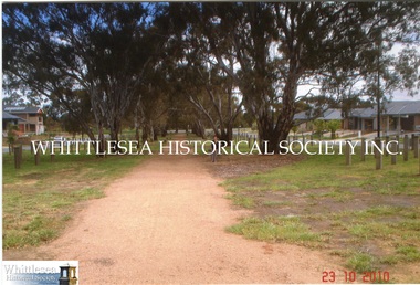
Photograph, Gwen Hawke, Road through to Wilton Vale, 2010
2 photographs showing the road through to Wilton Vale at Mernda where the original homestead stood.2 colour photographs.mernda, wilton vale mernda, rosyln wilson, smith family -
 Whittlesea Historical Society Inc.
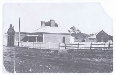
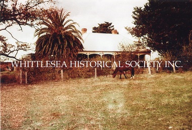
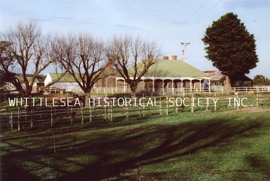
Photograph, Carome, Mernda, c. 1960
3 photographs showing Carome at Mernda dated mid 1960's. CAROME In 1840 Arthur Sergeantson purchased Section 19, Parish of Morang, a total of 842 acres. He named the property `Sergeantson Hall’ but the portion between the Plenty Road and Plenty River soon became known as Carome, the name of a flour mill he established in 1841. In 1843 Sergeantson leased the mill to a miller named Anderson, who operated it until 1850. Anderson was followed by Robert Charles. The present dwelling date back to at least 1850, and possibly earlier. In 1857 Sergeantson’s remaining 411 acres and Carome Mill were purchased by Abraham Willis and William Hardesty, who refurbished and upgraded the mill at the enormous cost of 1,200 Pounds. In 1868 the Mill was destroyed by fire. Willis continued farming at Carome until 1899 when he leased the farm to his son Robert and retired to Carlton. Little of the Mill remains. It was set just downstream from the deep rocky waterhole which formed a natural dam. Local folklore has it that this waterhole was used for water games by the Aborigines. Europeans certainly swim there now, and locals refer to this area as Power's hole, named after the previous owners the Power family. Such a prominent waterhole is likely to have been well known to the Aborigines. (Reference: City of Whittlesea Heritage Study) 3 colour photographs.mernda, carome mernda, bluestone, power family, willis family, abraham willis, isabella willis, carome mill, powers hole -
 Whittlesea Historical Society Inc.
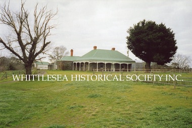
Photograph, Carome, Mernda, 2006
5 photographs showing Carome homestead and property at Mernda dated 2006. 1. Carome homestead. 2. Carome, looking southward down old rail line. 3. Carome homestead. 4. Dairy/feed sheds at Carome. 5. Carome property. CAROME In 1840 Arthur Sergeantson purchased Section 19, Parish of Morang, a total of 842 acres. He named the property `Sergeantson Hall’ but the portion between the Plenty Road and Plenty River soon became known as Carome, the name of a flour mill he established in 1841. In 1843 Sergeantson leased the mill to a miller named Anderson, who operated it until 1850. Anderson was followed by Robert Charles. The present dwelling date back to at least 1850, and possibly earlier. In 1857 Sergeantson’s remaining 411 acres and Carome Mill were purchased by Abraham Willis and William Hardesty, who refurbished and upgraded the mill at the enormous cost of 1,200 Pounds. In 1868 the Mill was destroyed by fire. Willis continued farming at Carome until 1899 when he leased the farm to his son Robert and retired to Carlton. Little of the Mill remains. It was set just downstream from the deep rocky waterhole which formed a natural dam. Local folklore has it that this waterhole was used for water games by the Aborigines. Europeans certainly swim there now, and locals refer to this area as Power's hole, named after the previous owners the Power family. Such a prominent waterhole is likely to have been well known to the Aborigines. (Reference: City of Whittlesea Heritage Study) 5 colour photographs.Printed on Kodak Royal Digital Papermernda, carome mernda, bluestone, power family, willis family, abraham willis, isabella willis, carome mill, powers hole, william hardesty, arthur sergeantson -
 Whittlesea Historical Society Inc.
Photograph - Copy, Alfred, Lucy, Florence and Charles Arnold, c.1910
A photograph of Alfred Arnold his wife Lucy (nee Willis) and their children Florence and Charles. Lucy is the daughter of Abraham and Isabella Willis of Carome in Mernda. CAROME In 1840 Arthur Sergeantson purchased Section 19, Parish of Morang, a total of 842 acres. He named the property `Sergeantson Hall’ but the portion between the Plenty Road and Plenty River soon became known as Carome, the name of a flour mill he established in 1841. In 1843 Sergeantson leased the mill to a miller named Anderson, who operated it until 1850. Anderson was followed by Robert Charles. The present dwelling date back to at least 1850, and possibly earlier. In 1857 Sergeantson’s remaining 411 acres and Carome Mill were purchased by Abraham Willis and William Hardesty, who refurbished and upgraded the mill at the enormous cost of 1,200 Pounds. In 1868 the Mill was destroyed by fire. Willis continued farming at Carome until 1899 when he leased the farm to his son Robert and retired to Carlton. Little of the Mill remains. It was set just downstream from the deep rocky waterhole which formed a natural dam. Local folklore has it that this waterhole was used for water games by the Aborigines. Europeans certainly swim there now, and locals refer to this area as Power's hole, named after the previous owners the Power family. Such a prominent waterhole is likely to have been well known to the Aborigines. (Reference: City of Whittlesea Heritage Study) Copy of black and white photograph.Printed on Kodak Professional Endura Papermernda, carome mernda, bluestone, power family, willis family, abraham willis, isabella willis, carome mill, powers hole, william hardesty, arthur sergeantson, alfred arnold, lucy willis, lucy arnold, florence arnold, charles arnold -
 Whittlesea Historical Society Inc.
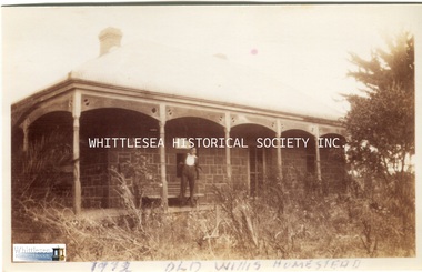
Photograph, Carome Homestead, Mernda, 1972
A photograph showing Carome homestead in Mernda dated 1972. CAROME In 1840 Arthur Sergeantson purchased Section 19, Parish of Morang, a total of 842 acres. He named the property `Sergeantson Hall’ but the portion between the Plenty Road and Plenty River soon became known as Carome, the name of a flour mill he established in 1841. In 1843 Sergeantson leased the mill to a miller named Anderson, who operated it until 1850. Anderson was followed by Robert Charles. The present dwelling date back to at least 1850, and possibly earlier. In 1857 Sergeantson’s remaining 411 acres and Carome Mill were purchased by Abraham Willis and William Hardesty, who refurbished and upgraded the mill at the enormous cost of 1,200 Pounds. In 1868 the Mill was destroyed by fire. Willis continued farming at Carome until 1899 when he leased the farm to his son Robert and retired to Carlton. Little of the Mill remains. It was set just downstream from the deep rocky waterhole which formed a natural dam. Local folklore has it that this waterhole was used for water games by the Aborigines. Europeans certainly swim there now, and locals refer to this area as Power's hole, named after the previous owners the Power family. Such a prominent waterhole is likely to have been well known to the Aborigines. (Reference: City of Whittlesea Heritage Study) Colour photograph.Printed on Kodak Professional Endura Paper.mernda, carome mernda, bluestone, power family, willis family, abraham willis, isabella willis, carome mill, powers hole, william hardesty, arthur sergeantson -
 Whittlesea Historical Society Inc.
Photograph - Copy, Carome Homestead, Mernda, 1932
A photograph of a man in front of Carome Homestead, 1932. CAROME In 1840 Arthur Sergeantson purchased Section 19, Parish of Morang, a total of 842 acres. He named the property `Sergeantson Hall’ but the portion between the Plenty Road and Plenty River soon became known as Carome, the name of a flour mill he established in 1841. In 1843 Sergeantson leased the mill to a miller named Anderson, who operated it until 1850. Anderson was followed by Robert Charles. The present dwelling date back to at least 1850, and possibly earlier. In 1857 Sergeantson’s remaining 411 acres and Carome Mill were purchased by Abraham Willis and William Hardesty, who refurbished and upgraded the mill at the enormous cost of 1,200 Pounds. In 1868 the Mill was destroyed by fire. Willis continued farming at Carome until 1899 when he leased the farm to his son Robert and retired to Carlton. Little of the Mill remains. It was set just downstream from the deep rocky waterhole which formed a natural dam. Local folklore has it that this waterhole was used for water games by the Aborigines. Europeans certainly swim there now, and locals refer to this area as Power's hole, named after the previous owners the Power family. Such a prominent waterhole is likely to have been well known to the Aborigines. (Reference: City of Whittlesea Heritage Study) Copy of a black and white photograph.Handwritten on the back: Carome Mernda 1932mernda, carome mernda, bluestone, power family, willis family, abraham willis, isabella willis, carome mill, powers hole, william hardesty, arthur sergeantson -
 Whittlesea Historical Society Inc.
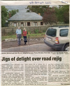
Newspaper - Newspaper Clipping, Whittlesea Leader, Jigs of delight over road rejig, 14 Feb 2006
Article about Richard & Jean Ely stopping Plenty Road shifting closer to their home.Newsprint with colour photomernda, richard ely, jean ely, the poplars mernda, bluestone house, mayfield precinct -
 Whittlesea Historical Society Inc.
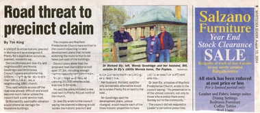
Newspaper - Newspaper Clipping, Whittlesea Leader, Road threat to precinct claim, 10 Aug 2004
... the Mayfield Precinct in Mernda becoming endangered if Plenty Road ...An article about the Mayfield Precinct in Mernda becoming endangered if Plenty Road is widened.Newsprint with colour photomernda, richard ely, jean ely, the poplars mernda, bluestone house, mayfield precinct, wendy goodridge, bill goodridge -
 Whittlesea Historical Society Inc.
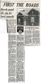
Newspaper - Newspaper Clipping, Copy, Whittlesea Post, First the roads
... of the Roads Board tolls in the City of Whittlesea mernda mernda ...A history of the Roads Board and tolls in the Whittlesea District.History of the Roads Board tolls in the City of WhittleseaNewsprint with 1 black and white photographmernda, mernda mechanics institute, roads board toll, epping district roads board, janefield toll, roads board, whittlesea shire council building -
 Whittlesea Historical Society Inc.
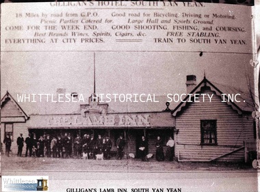
Photograph - Copy, Gilligan's The Lamb Inn, c.1900
A group of people in front of Gilligan's "The Lamb Inn" on Plenty Road in South Yan Yean (now Mernda). The now demolished Lamb Inn was built c.1840's.c.1840s building now demolishedA4 black and white copy of a photograph and digital image on HD. -
 Whittlesea Historical Society Inc.
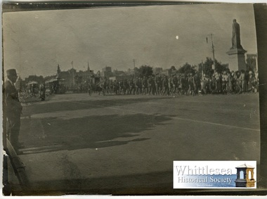
Photograph, Padre Hayes, Armistice Day, St. Kilda Road, 1918
Padre Hayes Collection. A collection of black and white/sepia photographs taken by Padre Herbert Edward Elton Hayes on Armistice Day 1918 in Melbourne, Vic.This photo forms part of a collection of photographs taken by Padre Herbert Edward Elton Hayes (1882-1960) who was a significant local figure in Mernda.Black and white photograph.St Kilda Road 1918padre hayes collection, armistice day 1918, ww1, army, mernda, herbert edward elton hayes, st kilda road, parade -
 Whittlesea Historical Society Inc.
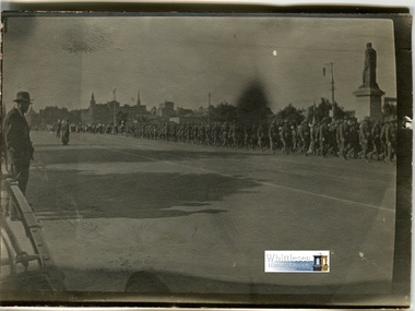
Photograph, Padre Hayes, Armistice Day, St. Kilda Road, 1918
Padre Hayes Collection. A collection of black and white/sepia photographs taken by Padre Herbert Edward Elton Hayes on Armistice Day 1918 in Melbourne, Vic. This photo forms part of a collection of photographs taken by Padre Herbert Edward Elton Hayes (1882-1960) who was a significant local figure in Mernda.Black and white photograph.St Kilda Road 1918padre hayes collection, armistice day 1918, ww1, army, mernda, herbert edward elton hayes, st kilda road, parade