Showing 79 items
matching mine battery head
-
 Bendigo Historical Society Inc.
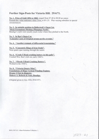
Document - VICTORIA HILL - NOTES ON VICTORIA HILL (SIGNS)
Twelve handwritten copied pages (a & b) of notes with typed copy of same, regarding the signs for Victoria Hill. Signs indicate the feature and a description including Prospecting Shafts, dams, engine beds, Lansell's Big 180 Shaft, stampers, Victoria Quartz Mine, Victoria Quartz Dams, Rae's Open Cut, Anticlinal Arch, small primitive tunnels, Engine-bed for Great Central Victoria known as 'Midway' mine, prospecting tunnels, floyd's small 5 Head Crushing Battery, Ballerstedt's Small 24 Yard Claim, The Humboldt 1856 to 1861, Luffsman and Sterry's Claim, and A Round Shaft.document, memo, victoria hill, victoria hill, notes on victoria hill (signs), lansell's big 180, ballerstedt senior, george lansell, victoria quartz mine, victoria reef quartz coy, wm rae, a roberts & sons, mr e j dunn, new chum drainage scheme, eureka extended, new chum railway, pearl, bendigo advertiser, inrush of water at the victoria quartz, victoria consols, shamrock, shenandoah, victoria quartz dams, rae's open cut. prospecting tunnel, floyd's small 5 head crushing battery, great central victoria (midway), midway no 2, midway north, ballerstedt's small 24 yard claim, the humboldt, wittscheibe, the adventure, advance, george lansell, luffsman & sterry's claim, david sterry, gold mines hotel, city of sandhurst, lansell's fortuna, a richardson -
 Bendigo Historical Society Inc.
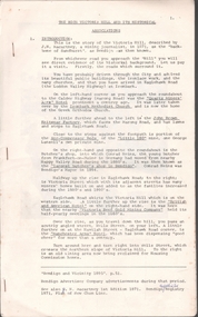
Document - VICTORIA HILL - ABRIDGED SIGNS FOR VICTORIA HILL
... First Open Cut,20 Head Crushing Battery, Victoria Quartz Mine... for Victoria Hill Ballerstedt's First Open Cut 20 Head Crushing Battery ...Handwritten carbon copy of notes with typed copy of same, for signs on Victoria Hill. Signs mentioned are: Ballerstedt's First Open Cut,20 Head Crushing Battery, Victoria Quartz Mine, Victoria Quartz Foundations of Steel Poppet Legs, Coloured rock formations, Primitive tunnels, Adit, Engine Beds Lansell's Big 180 Mine, Anticlinal Arch, Coloured rock formations marking and patterns. Notes prepared by Albert Richardson.document, gold, victoria hill, victoria hill, abridged signs for victoria hill, ballerstedt's first open cut, 20 head crushing battery, victoria quartz mine, victoria quartz foundations of steel poppet legs, coloured rock formations, primitive tunnels, adit, engine beds lansell's big 180 mine, anticlinal arch, coloured rock formations marking and patterns -
 Bendigo Historical Society Inc.
Document - MINING REPORTS - SEC. MINES REPORT FOR 1908
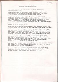
BHS CollectionHandwritten extract from the Sec. Mines Report for 1908. T. E. Williamson, Ins. Mines). Eaglehawk District. Page 130. Noes include Number of men employed and the depth of shaft for Collman & Tacchi, William's United, Koch's Pioneer, Nth Johnson & No 1, No 2 & No 3, Princess Dagmar, Needle, Golden Age, South New Moon, South New Moon 40 head battery, Catherine Reef United, New Moon and the Virginia. Also a new boiler reduced the wood consumption from 160 tons per week to 70 tons, whilst more work is being done.document, gold, mining reports, mining reports, sec mines report for 1908, collman & tacchi, william's united, koch's pioneer, nth johnson & no 1 no 2 no 3, princess dagmar, needle, golden age, south new moon, south new moon 40 head battery, catherine reef united, new moon, virginia -
 Bendigo Historical Society Inc.
Document - ALBERT RICHARDSON COLLECTION: SOUTH NEW MOON MINE EAGLEHAWK
Two-page typed document with map, detailing information on the South New Moon Gold Mine on the Garden Gully line of reef. Information includes the location, depth of shaft, steel poppet legs, engine house, air compressor, battery, company ownership, battery. The shaft The 'Walker and Coy' winding engine of the later company together with poppet heads was removed later to the South Virginia company between Napier and Market Street, Eaglehawk. Gold production from both companies who owned the mine was 257,498 oz.'.bendigo, mining, south new moon gold mine -
 Bendigo Historical Society Inc.
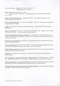
Document - NEW CHUM LINE OF REEF MUNGO GROUP EAGLEHAWK
Two page document detailing the Mungo Group of Mines along the New Chum line of reef, Eaglehawk. The mines described are: Ellenborough, 2100 feet deep St Mungo, 2,600 feet deep The Lady Barkly, 1,350 feet deep, close to Upper Road with a 40 head battery on the other side. South St Mungo, known as the Governor Barkly in the earlier days. Small map on second page shows the location of the Sadowa shaft, St. Mungo shaft and the Lady Barkly shaft. Victoria Street and Upper Road marked on the map. 'Between Caldwells Road and Victoria Street and Upper Road intersection, nine mines and three crushing batteries worked at one period. All on the New Chum line of reef.' Not signed but most probably written by Albert Richardson.bendigo, mining, mungo group of mines, eaglehawk -
 Bendigo Historical Society Inc.
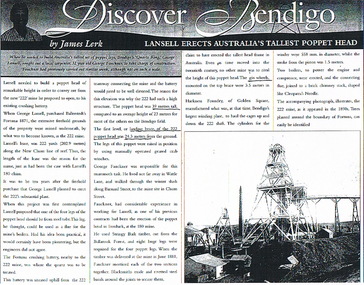
Newspaper - LONG GULLY HISTORY GROUP COLLECTION: LANSELL ERECTS AUSTRALIA'S TALLEST POPPET HEAD
BHS CollectionPhotocopy of a newspaper article titled Discover Bendigo by James Lerk. Article is titled Lansell Erects Australia's Tallest Poppet Head.George Fauckner was responsible for erecting the tall poppet head at the 222 mine. Eight huge logs were used to make the four legs which morticed together. Blacksmiths made and riveted steel bands around the joints to secure them. Harkness Foundry manufactured the winding plant which was the largest in Bendigo at that time. An accompanying photograph illustrates the 222 Mine as it appeared in the 1890's.bendigo, history, long gully history group, the long gully history group - lansell erects australia's tallest popper head, george fauckner, ballerstedt's fortuna, 222 mine, 180 mine, fortuna crushing battery, harkness foundry, cleopatra's needle, fortuna -
Bendigo Historical Society Inc.
Photograph - AUSTIN COLLECTION: Ray Beer, Central Deborah Gold Mine
Ray Beer was an employee of the Central Deborah Gold Mine. February 15th 2009: Bendigo Advertiser: 'MINING stalwart Raymond Beer has died at the age of 74 after a battle with cancer. He leaves behind an extended family and a legacy in Bendigo’s mining history. Ray was mine manager at the Central Deborah Gold Mine - appointed in 1978 - and led the team that made possible the underground project at the second level. He had a vision to allow visitors to go underground and experience Bendigo’s mining heritage first hand. Ray was responsible for developing the new battery, shaft and poppet head to make this a reality. It took persistence and lots of hard work. Friend and work colleague Bill McNamara said Ray was as good as 10 men. His enthusiasm and work ethic were unprecedented. Ray will be sadly missed by his wife, Thelma, six children, 15 grandchildren, seven brothers, three sisters, his extended family, and friends. He will be remembered for his kindness, tenacity and strength of character. In recognition of his contribution to Bendigo’s mining history, after more than 20 years of service at his retirement, a bronze life-sized statue was unveiled in his honour'. Central Deborah Gold Mine history: At its peak, Central Deborah Gold Mine reached a depth of 412 metres. It has 17 separate levels and 15 kilometres of drives and cross cuts (tunnels). The Central Deborah was very much a hands-on mine and the conditions that the miners worked in would be considered shocking by today's standards – being lowered underground in a cage with only two sides, often working ankle to knee deep in water, filling up to 32 ore trucks a shift by hand which were then pushed a mile or more along rails in the drives, working by carbide lamp, breathing in the fumes and rock dust and communication by bells. Geez, they were ironmen. However, at the time working conditions were considered to be among the best on the goldfields at Central Deborah, after all it was one of the only mines that had hot showers. Following Central Deborah Gold Mine's closure, the Bendigo skyline began to noticeably change. Obvious remnants of mining such as poppet heads, engine rooms, service quarters, battery houses and chimneys were steadily disappearing. After intense lobbying by the local community, the Bendigo City Council purchased the still very much intact Central Deborah Gold Mine in 1970 for a mere $6,000 to ensure that a vital link to Bendigo's historic golden past was maintained. The Bendigo Trust was then formed to oversee the operations of the Central Deborah Gold Mine, which led to the surface of the mine being opened to the public in 1971. Initially the surface was open for just 12 hours a week and as the demand for viewing a part of Bendigo's history increased, so did the opening hours. In 1974 the mine was gazetted as a Public Historical Purposes Reserve and attracted such visitors as H.R.H Prince Charles. By far the greatest shortcoming at this stage was that no one could view the underground workings, as these had become flooded. After what could only be described as a monumental effort by everyone involved, Level 2 of the mine was officially opened to the public by the Premier of Victoria, the Honourable John Cain, on 20 June 1986, which brought to fruition a long standing dream.Black and white photograph. Ray Beer, underground at Central Deborah Gold Mine, standing alongside wooden sign 'Murrell's Corner'. Sign is placed horizontally on timber supports; side of drive visible in background. Ray is wearing bib and brace overalls and hard hat with a belt around his waist. He is giving a 'thumbs up' sign. gold mining, central deborah gold mine, ray beer, mine manager -
Bendigo Historical Society Inc.
Photograph - AUSTIN COLLECTION: Central Deborah Gold Mine Lift Shaft
Central Deborah Gold Mine history: At its peak, Central Deborah Gold Mine reached a depth of 412 metres. It has 17 separate levels and 15 kilometres of drives and cross cuts (tunnels). The Central Deborah was very much a hands-on mine and the conditions that the miners worked in would be considered shocking by today's standards – being lowered underground in a cage with only two sides, often working ankle to knee deep in water, filling up to 32 ore trucks a shift by hand which were then pushed a mile or more along rails in the drives, working by carbide lamp, breathing in the fumes and rock dust and communication by bells. Geez, they were ironmen. However, at the time working conditions were considered to be among the best on the goldfields at Central Deborah, after all it was one of the only mines that had hot showers. Following Central Deborah Gold Mine's closure, the Bendigo skyline began to noticeably change. Obvious remnants of mining such as poppet heads, engine rooms, service quarters, battery houses and chimneys were steadily disappearing. After intense lobbying by the local community, the Bendigo City Council purchased the still very much intact Central Deborah Gold Mine in 1970 for a mere $6,000 to ensure that a vital link to Bendigo's historic golden past was maintained. The Bendigo Trust was then formed to oversee the operations of the Central Deborah Gold Mine, which led to the surface of the mine being opened to the public in 1971. Initially the surface was open for just 12 hours a week and as the demand for viewing a part of Bendigo's history increased, so did the opening hours. In 1974 the mine was gazetted as a Public Historical Purposes Reserve and attracted such visitors as H.R.H Prince Charles. By far the greatest shortcoming at this stage was that no one could view the underground workings, as these had become flooded. After what could only be described as a monumental effort by everyone involved, Level 2 of the mine was officially opened to the public by the Premier of Victoria, the Honourable John Cain, on 20 June 1986, which brought to fruition a long standing dream.Black and white photograph, looking from bottom of lift shaft towards the surface; light visible at top of shaft. Lift cables and safety mesh on sides of shaft. gold mining, central deborah gold mine, ray beer, mine manager -
Bendigo Historical Society Inc.
Photograph - AUSTIN COLLECTION: Central Deborah Gold Mine, Possibly 1990's
Central Deborah Gold Mine history: At its peak, Central Deborah Gold Mine reached a depth of 412 metres. It has 17 separate levels and 15 kilometres of drives and cross cuts (tunnels). The Central Deborah was very much a hands-on mine and the conditions that the miners worked in would be considered shocking by today's standards – being lowered underground in a cage with only two sides, often working ankle to knee deep in water, filling up to 32 ore trucks a shift by hand which were then pushed a mile or more along rails in the drives, working by carbide lamp, breathing in the fumes and rock dust and communication by bells. Geez, they were ironmen. However, at the time working conditions were considered to be among the best on the goldfields at Central Deborah, after all it was one of the only mines that had hot showers. Following Central Deborah Gold Mine's closure, the Bendigo skyline began to noticeably change. Obvious remnants of mining such as poppet heads, engine rooms, service quarters, battery houses and chimneys were steadily disappearing. After intense lobbying by the local community, the Bendigo City Council purchased the still very much intact Central Deborah Gold Mine in 1970 for a mere $6,000 to ensure that a vital link to Bendigo's historic golden past was maintained. The Bendigo Trust was then formed to oversee the operations of the Central Deborah Gold Mine, which led to the surface of the mine being opened to the public in 1971. Initially the surface was open for just 12 hours a week and as the demand for viewing a part of Bendigo's history increased, so did the opening hours. In 1974 the mine was gazetted as a Public Historical Purposes Reserve and attracted such visitors as H.R.H Prince Charles. By far the greatest shortcoming at this stage was that no one could view the underground workings, as these had become flooded. After what could only be described as a monumental effort by everyone involved, Level 2 of the mine was officially opened to the public by the Premier of Victoria, the Honourable John Cain, on 20 June 1986, which brought to fruition a long standing dream.Black and white photograph. Two men with hard hats and lights, inspecting quartz outcrop on wall of drive at Central Deborah Gold Mine.gold mining, central deborah gold mine, ray beer, mine manager -
Bendigo Historical Society Inc.
Photograph - AUSTIN COLLECTION: Operating rock drill, Central Deborah Gold Mine, Possibly 1990's
Central Deborah Gold Mine history: At its peak, Central Deborah Gold Mine reached a depth of 412 metres. It has 17 separate levels and 15 kilometres of drives and cross cuts (tunnels). The Central Deborah was very much a hands-on mine and the conditions that the miners worked in would be considered shocking by today's standards – being lowered underground in a cage with only two sides, often working ankle to knee deep in water, filling up to 32 ore trucks a shift by hand which were then pushed a mile or more along rails in the drives, working by carbide lamp, breathing in the fumes and rock dust and communication by bells. Geez, they were ironmen. However, at the time working conditions were considered to be among the best on the goldfields at Central Deborah, after all it was one of the only mines that had hot showers. Following Central Deborah Gold Mine's closure, the Bendigo skyline began to noticeably change. Obvious remnants of mining such as poppet heads, engine rooms, service quarters, battery houses and chimneys were steadily disappearing. After intense lobbying by the local community, the Bendigo City Council purchased the still very much intact Central Deborah Gold Mine in 1970 for a mere $6,000 to ensure that a vital link to Bendigo's historic golden past was maintained. The Bendigo Trust was then formed to oversee the operations of the Central Deborah Gold Mine, which led to the surface of the mine being opened to the public in 1971. Initially the surface was open for just 12 hours a week and as the demand for viewing a part of Bendigo's history increased, so did the opening hours. In 1974 the mine was gazetted as a Public Historical Purposes Reserve and attracted such visitors as H.R.H Prince Charles. By far the greatest shortcoming at this stage was that no one could view the underground workings, as these had become flooded. After what could only be described as a monumental effort by everyone involved, Level 2 of the mine was officially opened to the public by the Premier of Victoria, the Honourable John Cain, on 20 June 1986, which brought to fruition a long standing dream.Black and white photograph. Two men with hard hats and lights standing in front of underground rock surface at Central Deborah Gold Mine. Man on left hand side of image is operating a small rock drill. Man on right hand side is observing the procedure. gold mining, central deborah gold mine, rock drill, underground -
 Bendigo Historical Society Inc.
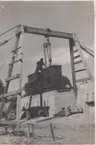
Photograph - Napoleon Reef Gold Mine Battery Site, 1936
The Napoleon (BML) gold mine (1932) was located beside McDougall Road, Golden Gully, between Martin and Hattam Street. It had a depth of 921 feet. It was one of the latest and most lavish of Bendigo's mines. Plant and equipment were electrically driven. The four-compartment shaft, extra large by goldfield's standards, measured 17 feet 6 inches by 5 feet 2 inches and was cement lined below 900 feet instead of being red gum boxed as was the usual practice. The workshop was equipped to carry out all repairs for the equally lavish BML mines on the Nell Gwynne and Carshalton reefs. (The Gold Mines of Bendigo, Book 2, Arthur Victor Palmer)Significant to mining history of Bendigo.Black and white photograph of a stamper head being lowered into position on the battery site of the Napoleon Reef Gold Mine. A wooden gantry supports the battery head as it being lowered, a man is standing on top of the stamper head. Concrete foundations are visible in immediate background. napoleon gold mine, napoleon reef gold mine -
 Bendigo Historical Society Inc.
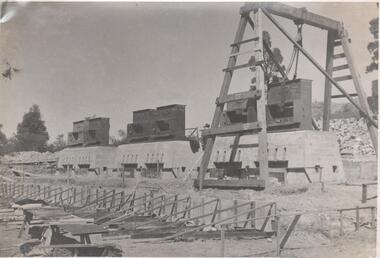
Photograph - Napoleon Reef Gold Mine Battery Site, 1936
The Napoleon (BML) gold mine (1932) was located near McDougall Road, Golden Gully, between Martin and Hattam Street. It had a depth of 921 feet. It was one of the latest and most lavish of Bendigo's mines. Plant and equipment were electrically driven. The four-compartment shaft, extra large by goldfield's standards, measured 17 feet 6 inches by 5 feet 2 inches and was cement lined below 900 feet instead of being red gum boxed as was the usual practice. The workshop was equipped to carry out all repairs for the equally lavish BML mines on the Nell Gwynne and Carshalton reefs. (The Gold Mines of Bendigo, Book 2, Arthur Victor Palmer) 'Napoleon BML Mines No Liability have issued a report for the fortnight ended September 5, where it states that the development scheme has been formulated and necessary equipment is being ordered. The Napoleon main shaft, (about 1700 feet south of the old Napoleon shaft) will be a four compartment shaft (17ft 6 inches by ft 2 inches inside the timber). aLevels will be opened at approximately 100 ft vertical intervals and cross-cuts extended approximately 125 ft each side of centre country to explore a cross-section across the anticline opposite to the shaft. At every fifth level, main drives will be extended north to connect with the old Napoleon shaft and south approximately 1800 ft. At the latter point, another cross-section of the anticline will be explored by rising and cross-cutting. The old Napoleon will be unwatered and on the 500ft and 1000 ft levels main drives will be driven to connect with main levels from the Napoleon main shaft to the south as well as being driven north 1800 ft where another cross-section of the anticline will be explored. Cross-sections further north and south may be developed as desired and also at intermediate points if necessary. Clearing and grading of the main shaft site are now in progress and the erection of the office and store building is proceeding. The design of engine room, change house and machine shops is now in hand and erection will proceed as soon as working plans and specifications are prepared.' The main shaft has been commenced at 3ft and advanced 10 ft. to 13 ft. https://trove.nla.gov.au/newspaper/article/10975478?searchTerm=napoleon%20bml (The Argus, 8th. September 1934, 'Mining' page 18) Significant to mining history of Bendigo.Black and white photograph of a stamper head being lowered into position on the battery site of the Napoleon Reef Gold Mine. A wooden gantry supports the battery head as it being lowered. Three large concrete foundations are visible in immediate background, two of which have stampers already in position, the third stamper is being lowered onto the final foundation. In immediate foreground, 'boxing' is erected for future concrete pours. napoleon gold mine, napoleon reef gold mine -
 Bendigo Historical Society Inc.
Document - VICTORIA HILL - THE RICH VICTORIA HILL 150,000 OZ OF GOLD IN SIX YEARS
Typed notes titled The Rich Victoria Hill - 150,000 oz of Gold in Six Years. Some handwritten notes have been added. Notes give a brief outline of the Victoria Hill. It also mentions the signposts at Victoria Hill.document, gold, victoria hill, victoria hill, the rich victoria hill 150, 000 oz of gold in six years, gold mines hotel, rotary club of bendigo south, city council, bendigo and district tourist association, lansell's 180, victoria quartz, central deborah mine, ballerstedt's first open cut, theodore ballerstedt, ballerstedt's 2nd open cut, 20 head crushing battery stampers, concrete dam, victoria quartz mine, rae's open cut, quartz roasting, great central victoria (midway), a richardson -
 Bendigo Historical Society Inc.
Document - VICTORIA HILL - THE RICH VICTORIA HILL AND ITS HISTORICAL ASSOCIATIONS
Copy and a photocopy of notes titled 'The rich Victoria Hill and its Historical Associations. The photocopy does not have copies of the photos. Notes include Introduction, directions for getting to Victoria Hill, North Old Chum Mine 2310 ft deep, Ballerstedt's First Open Cut, Geographical Features, Lansell's Big 180, Crushing Battery, Lansell's Cleopatra Needle type chimney, Victoria Quartz Mine 4613 ft deep, Victoria Reef Quartz Company, Victoria Quartz Company, Victoria Quartz Dams, Rae's Open Cut, Quartz Roasting, Floyd's small 5 Head Crushing Battery, Great Central Victoria (Midway) Shaft, Ballerstedt's Small 24 yard Claim, The Humboldt, The Adventure, The Advance and Luffsman and Sterry's Claim. Copies of photos include: Victoria Hill from Rae's Open Cut, Looking North from Old Chum Hill to the Victoria Hill, the Victoria Quartz Mine and Wm. Rae's Crushing Works.document, gold, victoria hill, the rich victoria hill and its historical associations, j n macartney, quartz miners' arms hotel, ironbark methodist church, john brown knitwear factory, little 180, george lansell, conrad heinz, british and american hotel, victoria reef gold mining company, manchester arms hotel, housing commission homes, the ironbark, hercules and energetic, midway, wittscheibe, great central victoria, wm rae, mr & mrs conroy, moorhead's shop, central nell gwynne, gold mines hotel, david chaplin sterry, new chum & victoria, old chum, burrowes & sterry, rotary club of bendigo south, big 180, north old chum mine, ballerstedt's first open-cut, lansell's bit 180 shaft, victoria quartz mine, victoria reef quartz company, a roberts & sons, mr e j dunn, h harkness & sons, new chum drainage scheme, eureka extended, new chum railway, the pearl, inrush of water, shamrock, shenandoah, victoria quartz dams, rae's open cut, floyd's small 5 head crushing battery, great central victoria (midway) shaft, midway no 2, midway north, the humboldt, the adventure, the advance, luffsman & sterry's claim, chinese joss house, fortuna, p m g repeater station, bendigo and vicinity 1895, j n macartney 1st edition 1871, mr rae anderson, 'gill family, annals of bendigo obituary notices 1904, mining records and australian mining standard special edition 1/6/1899, bendigo advertiser 22/6/1871, b m l records mines department, patterson's goldfields of victoria, dickers mining record 23/11/1861, annals of bendigo, bendigo advertiser 24/7/1933, 27/8/1908, 30/6/1910, 16/6/1910, 17/6/1910, mining reports for 1910, australian mining standard special edition 1/6/1899 p40, bendigo mines ltd, mines department records, the bendigo goldfield 1851 to 1954, the victoria hill 1854 to 1949, wm rae's crushing works -
 Bendigo Historical Society Inc.
Document - VICTORIA HILL - THE RICH VICTORIA HILL AND ITS HISTORICAL ASSOCIATIONS
Two typed copies of notes titled 'The Rich Victoria Hill and its Historical Associations'. Notes include notes on travel to Victoria Hill, picture from Rae's Open Cut, signpost for items of interest at Victoria Hill, picture Looking North from Old Chum Hill to the Victoria Hill, picture of the Victoria Quartz Mine and Rae's 35 Hd. Crushing Battery.document, gold, victoria hill, the rich victoria hill and its historical associations, j n macartney, quartz miners' arms hotel, ironbark methodist church, john brown knitwear factory, little 180 mine, conrad heinz, british and american hotel, victoria reef gold mining company, manchester arms hotel, housing commission homes, bendigo and vicinity 1895, bendigo advertiser, victoria hill from rae's open cut, nell gwynne poppet legs, robert wallace studios, ironbark 9victoria reef gold mines) hercules and energetic, midway, wittscheibe, great central victoria, william rae's home, mr and mrs conroy, william rae junior, moorhead's shop, gill family, gold mines hotel, david chaplin sterry, john brown knitwear factory, mr rae anderson, annals of bendigo, new chum and victoria, old chum, pioneer, burrowes and sterry's, new chum and victoria tribute, rotary club of bendigo south, big 180, victoria quartz mines, north old chum mine, ballerstedt's first open-cut, j n macartney bendigo goldfields registry 1871, b m l records mines department, john wybrandt, j c t christopher ballerstedt, theodore ballerstedt, from old chum to the victoria hill, george lansell, lansell's 'cleopatra needle' type chimney, 222 mine, sandhurst mine, a roberts & sons, australian mining standard special edition 1/6/1899, dickers mining record 23/11/1861, mr e j dunn, h harkness & sons, new chum drainage scheme, eureka extd, new chum railway, pearl, shamrock, shenandoah, new chum railway, floyd's small 5 head crushing battery, midway no 2, midway north, ballerstedt's small 24 yard claim, the humboldt, the adventure, luffsman and sterry's claim, chinese joss house, lansell's fortuna, p m g repeater station, a richardson, the bendigo goldfield 1851 to 1954, the victoria hill 1854 to 1949 -
 Bendigo Historical Society Inc.
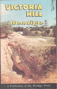
Book - VICTORIA HILL - VICTORIA HILL BENDIGO
Booklet titled: 'Victoria Hill Bendigo A Publication of the Bendigo Trust'. Booklet has photos of the Central Nell Gwynne Mine, Victoria Hill in the 1860's, with Rae's Battery in the foreground, geographical features, Rae's Open Cut, Victoria Hill from the New Chum Hill in the 1870's, compressor beds, The Victoria Quartz Mine, burnt ground from quartz roasting, the remains of a twenty head crushing battery, a view from Ballerstedt's Open Cut showing the historic Gold Mines Hotel built in 1857 and the engine beds of Lansell's '180' mine. There are also two maps, History of Victoria Hill and geographical notes on the area.book, bendigo, victoria hill -
 Bendigo Historical Society Inc.
Document - LANSELL'S BENDIGO BATTERY - NOTES ON LANSELL'S BENDIGO BATTERY
Two copies of notes on Lansell's Bendigo Battery. Ref. Bendigo Advertiser February 26th 1894. One copy is incomplete. Notes on formal opening of the 105 head battery, water supply and the Christening of the 6 engines connected with the battery by one of Mr Lansell's children. Another extract is from the Bendigo Advertiser dated Tuesday December 5th 1893 Page 3. Included in the notes is the description of the battery, driving engines, ripple tables, Halley's shaking tables, blanket tables, engines, Tambour Major plant, Mr Lansell, boilers, dams, the stack and names of engines Christened by one of Mr Lansell's children. Detailed description of the engines, etc.mining, surface equipment, lansell's bendigo battery, lansell's bendigo battery, notes on lansell's bendigo battery, bendigo advertiser 26/2/1894 & 5/12/1893, mr geo lansell, sheepshead line, water supply, mrs bassford, mr james northcott, tambour major coy, halley's shaking tables, johnson's gold mines, new red white & blue consolidated, north red white & blue -
 Bendigo Historical Society Inc.
Document - VICTORIA HILL - FURTHER SIGN-POSTS FOR VICTORIA HILL
... Crude 5 Head Crushing Battery Floyd's 5 Head Crushing Battery ...Handwritten carbon copy, with typed copy, of notes on further signs dated 29/4/71. Note at the end: Original given to Geo Ellis 29/4/1971. Notes include the price of gold and wording for some signs. Albert Richardson Collection. victoria hill, further sign-posts for victoria hill, price of gold, ballerstedt's open cut, rock formations, rae's open cut, crude 5 head crushing battery, floyd's 5 head crushing battery, victoria quartz mine, a roberts & sons, geo ellis -
 Bendigo Historical Society Inc.
Document - VICTORIA HILL - THE RICH VICTORIA HILL AND ITS HISTORICAL ASSOCIATIONS
Ten typed pages of notes and photocopied photos. Notes include Introduction which describes the journey between Bendigo and Eaglehawk. Notes also mention the Signposts at the Victoria Hill with their explanation. Dated 30/8/1971. The four photocopied photos are: (1) Victoria Hill - From Rae's Open Cut with the Central Nell Gwynne Popper Legs and the Victoria Hill Victoria Quartz Mullock in the background. (2) Looking North from Old Chum Hill to the Victoria Hill. (3) Victoria Quartz on Victoria Hill, Ironbark. (4) Rae's 35 Hd. Crushing Battery. Victoria Hill in background, Wm. Rae's early home top right.document, gold, victoria hill, the rich victoria hill and its historical associations, j n macartney, quartz miners' arms hotel, ironbark methodist church, john brown knitwear factory, little 180 mine, conrad heinz, british and american hotel, victoria reef gold mining company, manchester arms hotel, victoria hill from rae's open cut, ironbark (victoria reef gold mines), hercules and energetic, midway, wittscheibe, great central victoria, william rae, william rae junior, mr and mrs conroy, central nell gwynne, moorhead's shop, gill family, gold mines hotel, looking north from old chum hill to the victoria hill, new chum and victoria, old chum, pioneer, burrowes & sterry, rotary club of bendigo south, big 180, north old chum mine, ballerstedt's forst open cut, lansells big 180, george lansell, new chum syncline, lansell's 'cleopatra needle' type chimney, 222 mine, sandhurst or 'needle mine', victoria quartz mine, victoria reef quartz company, victoria quartz company, a roberts & sons, e j dunn, h harkness & sons, new chum drainage scheme, eureka extended, new chum railway, pearl, bendigo advertiser june 16 1910, rae's open cut, quartz roasting, anticlinal arch, prospecting tunnels, floyd's small 5 head crushing battery, great central victoria (midway), midway no2, midway north, ballerstedt's small 24 yard claim, the humboldt, wittscheibe, adventure, advance, luffsman & sterry, rae's 35 head crushing battery, a richardson, the bendigo goldfield 1851 to 1954, the victoria hill 1854 to 1949, australian mining standard special edition 1/6/1899, bendigo mines ltd, mines dept, bendigo advertiser, annals of bendigo, dickers mining record 23/11/1861, bendigo goldfields registry 1871, bendigo and vicinity 1895, mr rae anderson, w n macartney 1st edition 1871