Showing 210 items
matching mountain forest
-
 Marysville & District Historical Society
Booklet (Item) - Leisure guide, Michael Chesire & Associates Pty. Ltd, MARYSVILLE & DISTRICT LEISURE GUIDE-AUTUMN/WINTER, 1986, 1986
... marysville ski hire lake mountain ski school faraway forest scenic ...A free leisure guide to Marysville and the surrounding district published for Autumn and Winter, 1986. This was produced by Michael Cheshire as a free publication to promote tourism in Marysville and the surrounding district. It includes maps of the Big River Valley, Cumberland Valley, Lady Talbot Forest Drive, the Marysville area, and the township of Marysville. It was released in the autumn of 1986 and was sponsored by the Marysville Tourist & Progress Association. The Association was formed in November 1907 to promote tourism within the area. This included the physical creation of signage, parklands, roads, and walks to various attractions. A free leisure guide to Marysville and the surrounding district published for Autumn and Winter, 1986.marysville, victoria, australia, leisure guide, michael cheshire & associates pty ltd, marysville golf club, blackwood lodges, sir colin mackenzie fauna park, lake eildon, fraser national park, yarra valley wineries, marysville coach tours, kooringa, marylands guest house, lady talbot forest drive, wishing well, taggerty river recreation area, athols abbey, phantom falls, keppel falls, the beeches walking track, marylyn guest house, kufstein inn motel, the cumberland, marysville tourist & progress association, marysville newsagency & general store, crossways restaurant & motel, beauty spot walk, tree fern gully walk, michaeldene track, keppel track, woods lookout track, marysville hotel motel, lake mountain ski hire, marysville recreation and fun park, mytanta horseback safaris, upper big river valley, the big culvert, marysville mountain view horse hire, maryton park, amber view holiday lodges, cathedral restaurant, the top shop, tower motel, menzes garage, beauty spot nursery, marysville ski hire, lake mountain ski school, faraway forest, scenic motel, buxton trout farm, marysville hardware, timbertop steakhouse, marysville trout farm, healesville sanctuary, buxton hotel motel, nanda binya lodge, buxton antique and furniture mart, the black spur inn hotel, alexandra, lake mountain, geoffrey pope & associates -
 Marysville & District Historical Society
Map (Item) - Bush tracks map, John Siseman et al, MARYSVILLE BUSH TRACKS, 1987
A fold out map of the bush tracks in and around Marysville with information regarding each track. This map was published by Pindari Publications and distributed by Algona Publications. The track notes were compiled by John Siseman in 1987. The map was drawn by Glenn van der Knijff.A fold out map of the bush tracks in and around Marysville with information regarding each track.marysville, victoria, australia, map, bush tracks, pindari publications, algona publications, john siseman, gleen van der knijff, lady talbot forest drive, beauty spot walk, michaeldene track, steavenson falls, tree fern gully walk, trestle track, phantom falls, marysville town walk, marysville lookouts round walk, keppel falls, the beeches round walk, cumberland scenic reserve, cambarville, lake mountain, lake mountain walking track -
 Marysville & District Historical Society
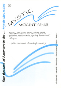
Ephemera (Item) - Visitor information pack, Four Seasons of Adventure in the Mystic Mountains, Unknown
A visitor information pack on Marysville and the surrounding district.A visitor information pack on Marysville and the surrounding district.marysville, victoria, australia, visitor information pack, lake mountain, narbethong, cathedral range, buxton, taggerty, mystic mountains, beauty spot walk, tree fern gully walk, michaeldene track, keppel track, woods lookout track, lady talbot forest drive, wishing well, taggerty river picnic area, taggerty river, phantom falls, keppel falls, the beeches walking track, mount sugarloaf, department of conservation & environment victoria -
 Marysville & District Historical Society
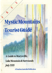
Ephemera (Item) - Tourist Guide, Graeme Haycraft, Mystic Mountains Tourist Guide July 1995, 07-1995
A tourist guide outlining services, accommodation, activities and places of interest to visit in and around Marysville, Lake Mountain and the local district.A tourist guide outlining services, accommodation, activities and places of interest to visit in and around Marysville, Lake Mountain and the local district.Acknowledgements/ Mystic Mountains Tourism Association, Marysville Office of the Dept. of Conser/ vation & Natural Resources, Mrs Elaine Postlethwaite, Ms Sue Henry & every/ advertiser without whose support this Guide would not have been possible.marysville, victoria, australia, tourist guide, mystic mountains, lake mountain, tourism australia, graeme haycraft, magic creek nursery, missing links miniature golf, phelps bakery, blackwood cottages, marysville hotel motel, tower motel, kerami house, marylands guest house, lomatia lodge, willowbank at taggerty, barree mud brick cottages, scenic motel, somerled mountain retreat, dalrymples guest cottages, nanda binya lodge, mathilde's of marysville country guest house, the birches resort, mystic mountains tourist information, marysville caravan park, the cumberland, igloo roadhouse, top shop pancake parlour, the silver birch restaurant, steavenson's restaurant, olde yarra track shoppe, danish coffee gardens, oscars take-away, country touch pottery studio & gallery, cumberland memorial scenic reserve, cathedral range state park, lady talbot forest drive, wishing well, taggerty river picnic area, taggerty river, phantom falls, keppels falls, the beeches walking track, mount sugarloaf, maryton park holiday cottages, snowviews, esa camping & conference centre, wirreanda festival, marysville post shop, hidden talent craft gallery, marysville automotive repairs, geoffrey pope & associates, beauty spot walk, tree fern gully walk, michaeldene track, marysville riding school, gerraty's ski centre, marysville holiday cottages, marysville triangle taxi service, fruit salad farm, lake mountain alpine resort, marysville ski hire, lake mountain ski school, cross country ski hire, lake mountain ski hire, marysville country club -
 Marysville & District Historical Society
Ephemera (Item) - Information sheet, Disney Entertainment Pty Ltd, JIM BROWN VISITS MARYSVILLE, 1995
An information sheet about Episode 12 of the television program Healthy Wealthy and Wise from May 1995. Healthy, Wealthy and Wise was a lifestyle television program shown in Australia. It was shown on Network Ten and was aired from 1992 until 1998. Jim Brown was the program's travel presenter.An information sheet pertaining to Episode 12 of the television program healthy wealthy & wise from May, 1995.EP. 12. MONDAY, 1st May, 1995marysville, victoria, australia, information sheet, healthy wealthy and wise, jim brown, stevensons falls, steavenson falls, lady talbot drive, lady talbot forest drive, cumberland reserve, valley of the giants, david rackman, dalrymples guest cottages, maryton park, mathilde's of marysville, lake mountain, disney entertainment pty ltd -
 Marysville & District Historical Society
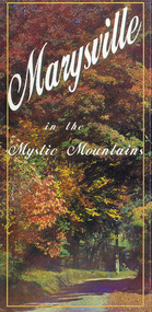
Map (Item) - Information brochure, Project Art & Photo, Marysville in the Mystic Mountains, Unknown
An information brochure on Marysville, the surrounding district and the natural attractions in the region published by Mystic Mountains Tourism.An information brochure on Marysville, the surrounding district and the natural attractions in the region published by Mystic Mountains Tourism.marysville, victoria, australia, information brochure, mystic mountains, mystic mountains tourism, cathedral range, lady talbot drive, cameron cascades, phantom falls, keppel falls, beech forest cascades, the beeches rainforest walk, the big tree, cumberland memorial scenic reserve, cambarville, cumberland falls, cora lynn falls, the big culvert, steavenson falls, lake mountain, marysville visitor information centre -
Marysville & District Historical Society
Flyer (item) - Information Flyer, Parks Victoria, Yarra Ranges National Park-Lady Talbot Drive, Cambarville and Lake Mountain-Visitor Guide, 01-2018
... lady talbot forest drive cambarville lake mountain sir reginald ...A flyer that was produced as a guide to Lady Talbot Drive, Cambarville and Lake Mountain.A flyer that was produced as a guide to Lady Talbot Drive, Cambarville and Lake Mountain. Lady Talbot Drive a 24 kilometer scenic rainforest car journey which passes a number of walks and waterfalls in the Yarra Ranges National Park. Lady Talbot Drive is named after Lady Sarah Elizabeth, the wife of Sir Reginald Talbot, who was the Governor of Victoria from 25th April, 1904 to 6th July 1908. Cambarville is notable for its giant mountain ash (Eucalyptus regnans) trees within the Cumberland Memorial Scenic Reserve, and relics from former sawmills and gold mining. The Big Culvert is located nearby on the Marysville-Woods Point Road, which was historically part of the Yarra Track. Cambarville was established as a timber mill town in the 1940s. Timber mill owners A Cameron and FJ Barton named Cambarville. They established the mill to salvage timber from trees destroyed in the 1939 bushfires. Cambarville was impacted by the 2009 Black Saturday bushfires and any remaining structures were destroyed. Lake Mountain is the closest alpine cross-country ski resort to Melbourne.lady talbot drive, lady talbot forest drive, cambarville, lake mountain, sir reginald talbot, lady sarah elizabeth talbot -
 Marysville & District Historical Society
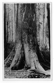
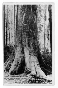
Postcard (item) - Black and white postcard, Valentine Publishing Co. Pty. Ltd, Tallest Known Hardwood Tree in the World, Height 301 Feet at Marysville, Vic. V10, 1923-1963
An early black and white photograph of the Big Tree in Cambarville in Victoria.An early black and white photograph of the Big Tree in Cambarville in Victoria. It was, at one stage, known to be the tallest hardwood tree in the world standing at 92 meters (301ft, 6 inches). However, it was reduced to 84 meters by a wind storm in 1959. It is a mountain ash. There is a walking track through the forest to the Big Tree. This postcard was published by Valentine Publishing Co. Pty. Ltd. as a souvenir of Marysville.VALENTINE'S/ POST/ CARD A GENUINE PHOTOGRAPHbig tree, mountain ash, cambarville, victoria, valentine publishing co, postcard, souvenir -
 Marysville & District Historical Society
Postcard (item) - Black and white postcard, Valentine Publishing Co. Pty. Ltd, Tallest Known Hardwood Tree in the World, Height 301 Feet at Marysville, Vic. V10, 1923-1963
An early black and white photograph of the Big Tree in Cambarville in Victoria.An early black and white photograph of the Big Tree in Cambarville in Victoria. It was, at one stage, known to be the tallest hardwood tree in the world standing at 92 meters (301ft, 6 inches). However, it was reduced to 84 meters by a wind storm in 1959. It is a mountain ash. There is a walking track through the forest that will take you to the Big Tree. This postcard was published by Valentine Publishing Co. Pty. Ltd. as a souvenir of Marysville.VALENTINE'S/ POST/ CARD A GENUINE PHOTOGRAPH Dear Mother & Dad I received your letter and/ was glad to know everything is OK at home./ The weather is still pretty good. Today is dull/ with a drop of rain every now & then but not enough/ to stop you from going out. Tomorrow we are going/ to the Eildon Weir so we are hoping it stays fine./ Had a letter from Mrs Thompson. She says Alison is/ doing fine. She has been playing with Judy/ You didnt way whether you were coming up here or/ not but I doubt whether you will get in after next/ week as it is the school holidays. Cumberland House/ seems to be very nice + it is on the main road let me/ know by return post & Ill see what I can do for you./ I think the tariff seems to be the same. Well dear thats all for/ now as I want to send a card to Auntie Love Ethel & Clarriebig tree, mountain ash, cambarville, victoria, valentine publishing co, postcard, souvenir -
 Marysville & District Historical Society
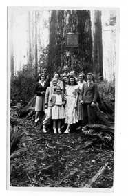
Photograph (item) - Black and white photograph, 02-1949
An early black and white photograph of the Big Tree in Cambarville in Victoria.An early black and white photograph of the Big Tree in Cambarville in Victoria. It was, at one stage, known to be the tallest hardwood tree in the world standing at 92 meters (301ft, 6 inches). However, it was reduced to 84 meters by a wind storm in 1959. It is a mountain ash. There is a walking track through the forest to the Big Tree.932 February 1949 Marysvillebig tree, mountain ash, cambarville, victoria, photograph -
 Marysville & District Historical Society
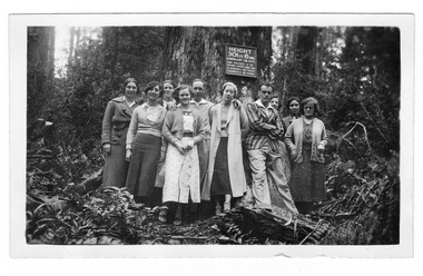
Photograph (item) - Black and white photograph, 12-1935
An early black and white photograph of the Big Tree in Cambarville in Victoria.An early black and white photograph of the Big Tree in Cambarville in Victoria. It was, at one stage, known to be the tallest hardwood tree in the world standing at 92 meters (301ft, 6 inches). However, it was reduced to 84 meters by a wind storm in 1959. It is a mountain ash. There is a walking track through the forest to the Big Tree.SUTHERLAND/ STUDIO/ HEALESVILLE Tall Trees at Cumberland/ Dec 1935big tree, mountain ash, cambarville, victoria, photograph -
 Marysville & District Historical Society
Photograph (item) - Black and white photograph, Unknown
An early black and white photograph of the Big Tree in Cambarville in Victoria.An early black and white photograph of the Big Tree in Cambarville in Victoria. It was, at one stage, known to be the tallest hardwood tree in the world standing at 92 meters (301ft, 6 inches). However, it was reduced to 84 meters by a wind storm in 1959. It is a mountain ash. There is a walking track through the forest to the Big Tree.The tallest Mountain Ash at the/ Cumberlandbig tree, mountain ash, cambarville, victoria, photograph -
 Marysville & District Historical Society
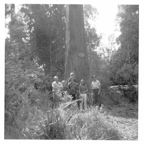
Photograph (item) - Colour photograph, Unknown
A colour photograph of the Big Tree in Cambarville in Victoria.A colour photograph of the Big Tree in Cambarville in Victoria. It was, at one stage, known to be the tallest hardwood tree in the world standing at 92 meters (301ft, 6 inches). However, it was reduced to 84 meters by a wind storm in 1959. It is a mountain ash. There is a walking track through the forest to the Big Tree.big tree, mountain ash, cambarville, victoria, photograph -
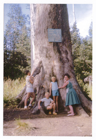
 Marysville & District Historical Society
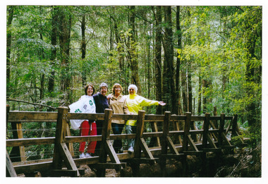
Photograph (item) - Colour photograph, 15-11-03
A colour photograph of a bridge that leads to Big Tree near Cambarville in Victoria.A colour photograph of a bridge that leads to Big Tree near Cambarville in Victoria. It was, at one stage, known to be the tallest hardwood tree in the world standing at 92 meters (301ft, 6 inches). However, it was reduced to 84 meters by a wind storm in 1959. It is a mountain ash. There is a walking track through the forest to the Big Tree.A weekend at Marysville 15-11-03 Catherine Pat Natasha & Normabig tree, mountain ash, cambarville, victoria, photograph -
 Marysville & District Historical Society
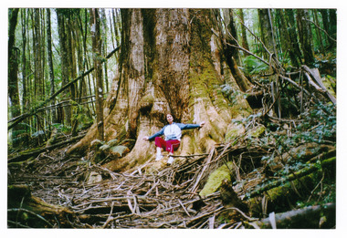
Photograph (item) - Colour photograph, 15-11-03
A colour photograph of the Big Tree in Cambarville in Victoria.A colour photograph of the Big Tree in Cambarville in Victoria. It was, at one stage, known to be the tallest hardwood tree in the world standing at 92 meters (301ft, 6 inches). However, it was reduced to 84 meters by a wind storm in 1959. It is a mountain ash. There is a walking track through the forest to the Big Tree.Catherine at Marysville 15-11-03big tree, mountain ash, cambarville, victoria, photograph -
Marysville & District Historical Society
Flyer (item) - Information flyer, Artworkz Tourism, Marysville-The Big Tree, 15-07-2020
A flyer that was produced as a guide to the Big Tree near Marysville in Victoria.A flyer that was produced as a guide to the Big Tree near Marysville in Victoria. The Big Tree was, at one stage, known to be the tallest hardwood tree in the world standing at 92 meters (301ft, 6 inches). However, it was reduced to 84 meters by a wind storm in 1959. It is a mountain ash. There is a walking track through the forest to the Big Tree.big tree, mountain ash, cambarville, victoria, marysville -
Marysville & District Historical Society
Document (item) - Word document, Rene de Koning, The Cumberland Giant Tree, 09-11-2022
An account of the early history of the Cumberland Giant Tree near Marysville in Victoria.An account of the early history of the Cumberland Giant Tree near Marysville in Victoria. The Big Tree was, at one stage, known to be the tallest hardwood tree in the world standing at 92 meters (301ft, 6 inches). However, it was reduced to 84 meters by a wind storm in 1959. It is a mountain ash. There is a walking track through the forest to the Big Tree.big tree, mountain ash, cambarville, victoria, marysville -
 Marysville & District Historical Society
Photograph (Item) - Black and white photograph, Beech Forest Beyond Tommy's Bend, c1900
An early black and white photograph of The Beeches, which is known as the Beech Grove, near Tommy's Bend near Marysville in Victoria.An early black and white photograph of The Beeches, which is known as the Beech Grove, near Tommy's Bend near Marysville in Victoria. Tommy's Bend is a stretch of road 10 kilometres from Marysville on the Wood's Point Road up to Lake Mountain. The Beeches Rainforest Walk is a loop that starts at Taggerty Cascades before winding through Myrtle Beech and Mountain Ash woodland and is one of the many walking tracks in and around Marysville. It is accessible from Lady Talbot Drive which is a 24 kilometer scenic rainforest car journey which passes a number of walks and waterfalls in the Yarra Ranges National Park. Lady Talbot Drive is named after Lady Sarah Elizabeth, the wife of Sir Reginald Talbot, who was the Governor of Victoria from 25th April, 1904 to 6th July 1908.ARMSTRONG COLLECTION 42 STATION STREET/ SANDRINGHAM 3191/ TEL. (03) 9521 5442/ IAN M.L. ARMSTRONG OAMtommy's bend, marysville, victoria, marysville-wood's point road, beech grove, wood's point road, lake mountain, beeches rainforest walk, taggerty cascades, myrtle beech, mountain ash, lady talbot drive, lady talbot forest drive, lady sarah elizabeth talbot, sir reginald talbot -
 Marysville & District Historical Society
Photograph (Item) - Black and white photograph, Way to Cumberland Falls, c1900
An early black and white photograph of the forest near the Cumberland Falls in Victoria.An early black and white photograph of the forest near the Cumberland Falls in Victoria. The falls are located on the Marysville-Wood's Point Road. Cambarville is notable for its giant mountain ash (Eucalyptus regnans) trees within the Cumberland Memorial Scenic Reserve, and relics from former sawmills and gold mining. The Big Culvert is located nearby on the Marysville - Woods Point Road, which was historically part of the Yarra Track. Cambarville was established as a timber mill town in the 1940s. Timber mill owners A Cameron and FJ Barton named Cambarville. They established the mill to salvage timber from trees destroyed in the 1939 bushfires. Cambarville was impacted by the 2009 Black Saturday bushfires and any remaining structures were destroyed.ARMSTRONG COLLECTION 42 STATION STREET/ SANDRINGHAM 3191/ TEL. (03) 9521 5442/ IAN M.L. ARMSTRONG OAMcumberland falls, cambarville, marysville, victoria, waterfalls, postcard, souvenir, mountain ash, mining, timber mills, big culvert, yarra track, a cameron, fj barton, black saturday bushfires, 1939 bushfires, eucalyptus regnans -
Marysville & District Historical Society
Document (Item) - Newspaper article, The Argus, New Tourist Road. Marysville to Wood's Point Magnificent Forest Scenery, 02-1924
A newspaper article regarding the opening of the Marysville-Wood's Point Road in February 1924.A newspaper article regarding the opening of the Marysville-Wood's Point Road in February 1924. The Marysville-Woods Point Road was originally part of the Yarra Track, constructed in the early 1860s to provide access between Healesville and the Woods Point Goldfields. Despite the steep terrain and engineering difficulties, the Yarra Track soon became a busy route used by pack horses, horse-drawn drays, and wagons. Today this sealed mountain road is a popular scenic drive between Marysville and Warburton.marysville-wood's point road, yarra track, healesville, wood's point goldfields, warburton, the argus -
 Marysville & District Historical Society
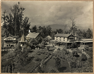
Photograph (Item) - Black and white photograph, Unknown
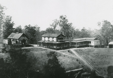
... and the surrounding forest of towering mountain ash. Aged 81 Lindt died ...An early black and white photograph of "The Hermitage" at Narbethong in Victoria.An early black and white photograph of "The Hermitage" at Narbethong in Victoria. "The Hermitage" was built by photographer John William Lindt as a home and guesthouse in 1894. John Lindt had previously photographed the mountain scenery of the Black Spur and purchased 71 acres and subseqently built his home and guesthouse from where he continued his career. "The Hermitage had a garden designed by John Lindt's friend, Ferdinand von Mueller, who was at one stage the Director of the Melbourne Botanic Gardens. The garden featured New Guinea tree houses from which John Lindt made frequent panoramas of his property and the surrounding forest of towering mountain ash. Aged 81 Lindt died of heart failure during disastrous bushfires on 19 February 1926 at the Hermitage. He was survived by his wife Catherine who continued to run ‘The Hermitage’ guest house before she retired to the city.the hermitage, john william lindt, narbethong, victoria, black spur, ferdinand von mueller, melbourne botanic gardens, new guinea, catherine lindt -
 Marysville & District Historical Society
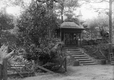
Photograph (Item) - Black and white photograph, John William Lindt, 1890-1910
... property and the surrounding forest of towering mountain ash. Aged ...A digital copy of an early black and white photograph taken of "The Hermitage" in Narbethong in Victoria.A digital copy of an early black and white photograph taken of "The Hermitage" in Narbethong in Victoria. "The Hermitage" was built by photographer John William Lindt as a home and guesthouse in 1894. John Lindt had previously photographed the mountain scenery of the Black Spur and purchased 71 acres and subseqently built his home and guesthouse from where he continued his career. "The Hermitage had a garden designed by John Lindt's friend, Ferdinand von Mueller, who was at one stage the Director of the Melbourne Botanic Gardens. The garden featured New Guinea tree houses from which John Lindt made frequent panoramas of his property and the surrounding forest of towering mountain ash. Aged 81 Lindt died of heart failure during disastrous bushfires on 19 February 1926 at the Hermitage. He was survived by his wife Catherine who continued to run ‘The Hermitage’ guest house before she retired to the city.the hermitage, john william lindt, narbethong, victoria, black spur, ferdinand von mueller, melbourne botanic gardens, new guinea, catherine lindt -
 Marysville & District Historical Society
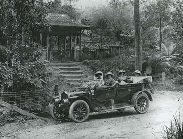
Photograph (Item) - Black and white photograph, John William Lindt, 1910
... and the surrounding forest of towering mountain ash. Aged 81 Lindt died ...A digital copy of an early black and white photograph of the entrance gate to "The Hermitage" at Narbethong in Victoria.A digital copy of an early black and white photograph of the entrance gate to "The Hermitage" at Narbethong in Victoria. "The Hermitage" was built by photographer John William Lindt as a home and guesthouse in 1894. John Lindt had previously photographed the mountain scenery of the Black Spur and purchased 71 acres and subseqently built his home and guesthouse from where he continued his career. "The Hermitage had a garden designed by John Lindt's friend, Ferdinand von Mueller, who was at one stage the Director of the Melbourne Botanic Gardens. The garden featured New Guinea tree houses from which John Lindt made frequent panoramas of his property and the surrounding forest of towering mountain ash. Aged 81 Lindt died of heart failure during disastrous bushfires on 19 February 1926 at the Hermitage. He was survived by his wife Catherine who continued to run ‘The Hermitage’ guest house before she retired to the city. Visitors to the Hermitage alighted from horse-drawn vehicles and later motor coaches to enter the estate through the lich-gate in the background.the hermitage, john william lindt, narbethong, victoria, black spur, ferdinand von mueller, melbourne botanic gardens, new guinea, catherine lindt -
 Marysville & District Historical Society
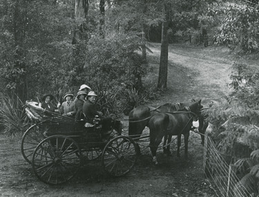
Photograph (Item) - Black and white photograph, John William Lindt, 1912
... property and the surrounding forest of towering mountain ash. Aged ...An early black and white photograph taken at the entrance to "The Hermitage" in Narbethong in Victoria.An early black and white photograph taken at the entrance to "The Hermitage" in Narbethong in Victoria. "The Hermitage" was built by photographer John William Lindt as a home and guesthouse in 1894. John Lindt had previously photographed the mountain scenery of the Black Spur and purchased 71 acres and subseqently built his home and guesthouse from where he continued his career. "The Hermitage had a garden designed by John Lindt's friend, Ferdinand von Mueller, who was at one stage the Director of the Melbourne Botanic Gardens. The garden featured New Guinea tree houses from which John Lindt made frequent panoramas of his property and the surrounding forest of towering mountain ash. Aged 81 Lindt died of heart failure during disastrous bushfires on 19 February 1926 at the Hermitage. He was survived by his wife Catherine who continued to run ‘The Hermitage’ guest house before she retired to the city.the hermitage, john william lindt, narbethong, victoria, black spur, ferdinand von mueller, melbourne botanic gardens, new guinea, catherine lindt -
 Marysville & District Historical Society
Photograph (Item) - Black and white photograph, John William Lindt, 1910
... and the surrounding forest of towering mountain ash. Aged 81 Lindt died ...An early black and white photograph taken near the entrance gatehouse to "The Hermitage" at Narbethong in Victoria.An early black and white photograph taken near the entrance gatehouse to "The Hermitage" at Narbethong in Victoria. "The Hermitage" was built by photographer John William Lindt as a home and guesthouse in 1894. John Lindt had previously photographed the mountain scenery of the Black Spur and purchased 71 acres and subseqently built his home and guesthouse from where he continued his career. "The Hermitage had a garden designed by John Lindt's friend, Ferdinand von Mueller, who was at one stage the Director of the Melbourne Botanic Gardens. The garden featured New Guinea tree houses from which John Lindt made frequent panoramas of his property and the surrounding forest of towering mountain ash. Aged 81 Lindt died of heart failure during disastrous bushfires on 19 February 1926 at the Hermitage. He was survived by his wife Catherine who continued to run ‘The Hermitage’ guest house before she retired to the city.the hermitage, john william lindt, narbethong, victoria, black spur, ferdinand von mueller, melbourne botanic gardens, new guinea, catherine lindt -
 Marysville & District Historical Society
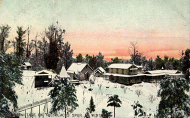
Postcard (Item) - Colour tinted postcard, John William Lindt, The Hermitage on the Black Spur in Winter, 1900s
... and the surrounding forest of towering mountain ash. Aged 81 Lindt died ...A digital copy of an early colour tinted postcard of "The Hermitage" in Narbethong in Victoria.A digital copy of an early colour tinted postcard of "The Hermitage" in Narbethong in Victoria. "The Hermitage" was built by photographer John William Lindt as a home and guesthouse in 1894. John Lindt had previously photographed the mountain scenery of the Black Spur and purchased 71 acres and subseqently built his home and guesthouse from where he continued his career. "The Hermitage had a garden designed by John Lindt's friend, Ferdinand von Mueller, who was at one stage the Director of the Melbourne Botanic Gardens. The garden featured New Guinea tree houses from which John Lindt made frequent panoramas of his property and the surrounding forest of towering mountain ash. Aged 81 Lindt died of heart failure during disastrous bushfires on 19 February 1926 at the Hermitage. He was survived by his wife Catherine who continued to run ‘The Hermitage’ guest house before she retired to the city.the hermitage, john william lindt, narbethong, victoria, black spur, ferdinand von mueller, melbourne botanic gardens, new guinea, catherine lindt, winter -
 Marysville & District Historical Society
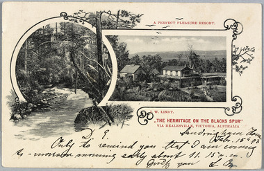
Postcard (Item) - Black and white postcard, John William Lindt, "The Hermitage on the Blacks Spur" via Healesville, Victoria, Australia: A Perfect Pleasure Resort, 1900s
... and the surrounding forest of towering mountain ash. Aged 81 Lindt died ...A digital copy of an early black and white postcard of "The Hermitage" at Narbethong in Victoria.A digital copy of an early black and white postcard of "The Hermitage" at Narbethong in Victoria. "The Hermitage" was built by photographer John William Lindt as a home and guesthouse in 1894. John Lindt had previously photographed the mountain scenery of the Black Spur and purchased 71 acres and subseqently built his home and guesthouse from where he continued his career. "The Hermitage had a garden designed by John Lindt's friend, Ferdinand von Mueller, who was at one stage the Director of the Melbourne Botanic Gardens. The garden featured New Guinea tree houses from which John Lindt made frequent panoramas of his property and the surrounding forest of towering mountain ash. Aged 81 Lindt died of heart failure during disastrous bushfires on 19 February 1926 at the Hermitage. He was survived by his wife Catherine who continued to run ‘The Hermitage’ guest house before she retired to the city.Sandringham South/ Feb. 15th. 03/ D.L./ Only to remind you that I am coming/ As-morrow morning early about 11.15 a.m./ Greetg you L Mthe hermitage, john william lindt, narbethong, victoria, black spur, ferdinand von mueller, melbourne botanic gardens, new guinea, catherine lindt, collotype -
 Marysville & District Historical Society
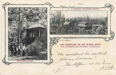
Postcard (Item) - Black and white postcard, John William Lindt, "The Hermitage on the Blacks Spur" via Healesville, Victoria, Australia: A Perfect Pleasure Resort, 1900s
... and the surrounding forest of towering mountain ash. Aged 81 Lindt died ...A digital copy of an early black and white postcard of "The Hermitage" at Narbethong in Victoria.A digital copy of an early black and white postcard of "The Hermitage" at Narbethong in Victoria. "The Hermitage" was built by photographer John William Lindt as a home and guesthouse in 1894. John Lindt had previously photographed the mountain scenery of the Black Spur and purchased 71 acres and subseqently built his home and guesthouse from where he continued his career. "The Hermitage had a garden designed by John Lindt's friend, Ferdinand von Mueller, who was at one stage the Director of the Melbourne Botanic Gardens. The garden featured New Guinea tree houses from which John Lindt made frequent panoramas of his property and the surrounding forest of towering mountain ash. Aged 81 Lindt died of heart failure during disastrous bushfires on 19 February 1926 at the Hermitage. He was survived by his wife Catherine who continued to run ‘The Hermitage’ guest house before she retired to the city."She couldnt be called/ plain, however."/ The affair at the Inn./ IS/ p 1 hh.the hermitage, john william lindt, narbethong, victoria, black spur, ferdinand von mueller, melbourne botanic gardens, new guinea, catherine lindt, collotype -
 Marysville & District Historical Society
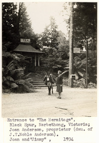
Photograph (Item) - Black and white photograph, Phyllis Bromby, 1934
... and the surrounding forest of towering mountain ash. Aged 81 Lindt died ...A digital copy of a black and white photograph taken at the entrance to "The Hermitage" at Narbethong in Victoria.A digital copy of a black and white photograph taken at the entrance to "The Hermitage" at Narbethong in Victoria. "The Hermitage" was built by photographer John William Lindt as a home and guesthouse in 1894. John Lindt had previously photographed the mountain scenery of the Black Spur and purchased 71 acres and subseqently built his home and guesthouse from where he continued his career. "The Hermitage had a garden designed by John Lindt's friend, Ferdinand von Mueller, who was at one stage the Director of the Melbourne Botanic Gardens. The garden featured New Guinea tree houses from which John Lindt made frequent panoramas of his property and the surrounding forest of towering mountain ash. Aged 81 Lindt died of heart failure during disastrous bushfires on 19 February 1926 at the Hermitage. He was survived by his wife Catherine who continued to run ‘The Hermitage’ guest house before she retired to the city. In the early 1930s, Joan Anderson purchased the property, maintaining it as a guesthouse.Entrance to "The Hermitage",/ Black Spur, Narbethong, Victoria;/ Joan Anderson, proprietor (dau of/ J.T. Noble Anderson)./ Joan and "Jimmy", 1934the hermitage, john william lindt, narbethong, victoria, black spur, ferdinand von mueller, melbourne botanic gardens, new guinea, catherine lindt, joan anderson