Showing 99 items matching "mt cooper"
-
 Kiewa Valley Historical Society
Photos - x 29 Falls Creek and Bogong High Plains
Photos taken by Alec McCullock circa 1980s. Some of the people include Brian Goss, Bright Shire or Water Board; Graham Cooper, Bright Shire and Paul Goldstone, Bright Shire Surveyor. Appears to be an inspection party comprising Shire, UK Water Board, SECV and other.These men represented the local organisations of the day. Historic changes include the diversity of people who represent organisations today and the actual type of organisations that exist.Coloured Falls Creek & Bogong High Plains c 1980s. Includes SECV People and work s.e.c.v. 1980s, bright shire 1980s -
 Eltham District Historical Society Inc
Photograph, Hume and Hovell passed here at Seymour 28 Oct 1824, Spring Excursion, Hume and Hovell's 1824 expedition (Part 2), 26 October 1997, 26/10/1997
[article by Diana Bassett-Smith in EDHS Newsletter No. 117, November 1997:] MONUMENT HUNTING THE HUME AND HOVELL WAY - Sunday October 26 1997 dawned bright and very warm. Some twenty-five members, complete with picnic baskets, met outside the Eltham Library awaiting the Cobb and Co. large coach which would be taking us on the second leg of our travels along the route of the early explorers Hume and Hovell. Stephen West was our very good driver for the day. He would be guided around the circuitous route by Russell Yeoman who had made a detailed study, not only of the intended route, but of the story of these two explorers. During the trip Russell regaled us with poetry, quotations from the Journals and the History of the Shire of Seymour, "The New Crossing Place" by Martindale, 1982, (now Mitchell Shire due to the recent amalgamations). We headed towards the Hume Highway via Greensborough and Cooper Street and proceeded north to our first stop, noting on the way Monument Hill in the distance which is near Kilmore and, according to Russell, well worth the effort to visit as the view across the valley is magnificent. Past Sunday Creek Valley, Mt Piper and Mt Disappointment, all traversed and noted and named by them. We passed through Tallarook, then onto Seymour where we took photos of the monument telling us that Hume and Hovell had passed through on the 28th of October 1824. We also deviated down Hume and Hovell Road viewing deer and emu farming and the Bellbourie property now a sanctuary. Leaving Seymour behind we travelled up the Avenel Road to the Avenel monument, pyramidal in design of four reducing square blocks with a sharply pointed peak, erected in 1924 in memory of the 1824 exploration. The day was warming up and the countryside showing the dryness of the current drought. A parallel note had been made in their journal too of 1824 of the drought appearance of the country they were traversing. At Seven Creeks, Euroa we stopped for some minutes to check the monument placed 20th November 1924 to commemorate their passage on the 29th December 1824. More photos. Russell had pointed out the abrupt termination of the distant ranges which is noted in their journal. The next monument is beside the road at the entrance to Honey Suckle Creek Caravan Park, Violet Town. The squarish shaped monument some eight feet high is topped with a simple steel cross, and was to mark the date of 28th December 1824 and built for the 20th November 1924. By now it was 12.20 and nearly lunchtime as we drove along the Warranbayne Road to Roach's Road, monument hunting without success. Though there is a large, what appears to be an old timber sign which was hard to read, maybe this was the lost monument. In many of the paddocks hay had been cut and baled or was being cut, what a contrast to the rugged country they had passed through which was smoky from the fires of the natives burning off. By 1.00 pm we were at Benalla and pulled up beside the park where abundant beds of roses filled the air with their scent and the smell of barbecued food twitched the nostrils whilst the cheerful sounds of other picnickers could be heard throughout the park. We left the bus and collected up our picnics, dispersed to the various tables and enjoyed the shade from the various European trees. 2.00 pm and we were on the road again driving along the Benalla, Mansfield, Yea road. The Swanpool monument states that they passed four miles south and returned three miles north. Then we stopped at the Barjarg monument which notes that they camped near this spot. It is again a pyramidal monument and this time topped with a steel arrow indicating their route of the 29th November 1824. Half an hour later we came to another monument, again with a steel arrow marker on top and the plaque dated the 2nd of 12th 1824. Erected on the 12th of 12th 1924. "They blazed the way that we might inherit the land." Another square based and needle topped monument appeared at Yarck near Yea and this plaque records the date of 3 December 1824. Near McGuigans Road Russell related that the expedition had lost a dog but it had found them next day, the dog was apparently torn by a kangaroo. A short while later Russell reminded us here of the problems they encountered in crossing the Goulburn River near Molesworth where banks were high, water deep and wide. "Good coat of grass but quite dry due to drought". At Yea we stopped for afternoon tea and raided the last of our picnics and looked at the monument to their journey of 1824, situated at a corner of the gardens near the bowling green. No photo – we were out of film. We returned home via Kinglake West and Whittlesea past the Yan Yean Reservoir, not full. 5.00 pm back at Eltham we emptied out of the bus and everyone, including Joan Cole, collected their things, Joan also had the major souvenir of the day, a large carp she had picked up from the river bank, her cat was in for a great feast. The day was made so interesting by the informed commentary which Russell provided. His background knowledge of the route and nature of the journey could only have come from many hours of reading and driving the area. Thank you to Russell and to everyone who made the day so informative and pleasurable. Colour photographactivities, hume and hovell, monument, seymour -
 Eltham District Historical Society Inc
Photograph, Gaol at Seymour, Spring Excursion, Hume and Hovell's 1824 expedition (Part 2), 26 October 1997, 26/10/1997
[article by Diana Bassett-Smith in EDHS Newsletter No. 117, November 1997:] MONUMENT HUNTING THE HUME AND HOVELL WAY - Sunday October 26 1997 dawned bright and very warm. Some twenty-five members, complete with picnic baskets, met outside the Eltham Library awaiting the Cobb and Co. large coach which would be taking us on the second leg of our travels along the route of the early explorers Hume and Hovell. Stephen West was our very good driver for the day. He would be guided around the circuitous route by Russell Yeoman who had made a detailed study, not only of the intended route, but of the story of these two explorers. During the trip Russell regaled us with poetry, quotations from the Journals and the History of the Shire of Seymour, "The New Crossing Place" by Martindale, 1982, (now Mitchell Shire due to the recent amalgamations). We headed towards the Hume Highway via Greensborough and Cooper Street and proceeded north to our first stop, noting on the way Monument Hill in the distance which is near Kilmore and, according to Russell, well worth the effort to visit as the view across the valley is magnificent. Past Sunday Creek Valley, Mt Piper and Mt Disappointment, all traversed and noted and named by them. We passed through Tallarook, then onto Seymour where we took photos of the monument telling us that Hume and Hovell had passed through on the 28th of October 1824. We also deviated down Hume and Hovell Road viewing deer and emu farming and the Bellbourie property now a sanctuary. Leaving Seymour behind we travelled up the Avenel Road to the Avenel monument, pyramidal in design of four reducing square blocks with a sharply pointed peak, erected in 1924 in memory of the 1824 exploration. The day was warming up and the countryside showing the dryness of the current drought. A parallel note had been made in their journal too of 1824 of the drought appearance of the country they were traversing. At Seven Creeks, Euroa we stopped for some minutes to check the monument placed 20th November 1924 to commemorate their passage on the 29th December 1824. More photos. Russell had pointed out the abrupt termination of the distant ranges which is noted in their journal. The next monument is beside the road at the entrance to Honey Suckle Creek Caravan Park, Violet Town. The squarish shaped monument some eight feet high is topped with a simple steel cross, and was to mark the date of 28th December 1824 and built for the 20th November 1924. By now it was 12.20 and nearly lunchtime as we drove along the Warranbayne Road to Roach's Road, monument hunting without success. Though there is a large, what appears to be an old timber sign which was hard to read, maybe this was the lost monument. In many of the paddocks hay had been cut and baled or was being cut, what a contrast to the rugged country they had passed through which was smoky from the fires of the natives burning off. By 1.00 pm we were at Benalla and pulled up beside the park where abundant beds of roses filled the air with their scent and the smell of barbecued food twitched the nostrils whilst the cheerful sounds of other picnickers could be heard throughout the park. We left the bus and collected up our picnics, dispersed to the various tables and enjoyed the shade from the various European trees. 2.00 pm and we were on the road again driving along the Benalla, Mansfield, Yea road. The Swanpool monument states that they passed four miles south and returned three miles north. Then we stopped at the Barjarg monument which notes that they camped near this spot. It is again a pyramidal monument and this time topped with a steel arrow indicating their route of the 29th November 1824. Half an hour later we came to another monument, again with a steel arrow marker on top and the plaque dated the 2nd of 12th 1824. Erected on the 12th of 12th 1924. "They blazed the way that we might inherit the land." Another square based and needle topped monument appeared at Yarck near Yea and this plaque records the date of 3 December 1824. Near McGuigans Road Russell related that the expedition had lost a dog but it had found them next day, the dog was apparently torn by a kangaroo. A short while later Russell reminded us here of the problems they encountered in crossing the Goulburn River near Molesworth where banks were high, water deep and wide. "Good coat of grass but quite dry due to drought". At Yea we stopped for afternoon tea and raided the last of our picnics and looked at the monument to their journey of 1824, situated at a corner of the gardens near the bowling green. No photo – we were out of film. We returned home via Kinglake West and Whittlesea past the Yan Yean Reservoir, not full. 5.00 pm back at Eltham we emptied out of the bus and everyone, including Joan Cole, collected their things, Joan also had the major souvenir of the day, a large carp she had picked up from the river bank, her cat was in for a great feast. The day was made so interesting by the informed commentary which Russell provided. His background knowledge of the route and nature of the journey could only have come from many hours of reading and driving the area. Thank you to Russell and to everyone who made the day so informative and pleasurable. Colour photographactivities, hume and hovell, seymour, gaol -
 Eltham District Historical Society Inc
Photograph, Hume and Hovell Monument, Avenel, Spring Excursion, Hume and Hovell's 1824 expedition (Part 2), 26 October 1997, 26/10/1997
[article by Diana Bassett-Smith in EDHS Newsletter No. 117, November 1997:] MONUMENT HUNTING THE HUME AND HOVELL WAY - Sunday October 26 1997 dawned bright and very warm. Some twenty-five members, complete with picnic baskets, met outside the Eltham Library awaiting the Cobb and Co. large coach which would be taking us on the second leg of our travels along the route of the early explorers Hume and Hovell. Stephen West was our very good driver for the day. He would be guided around the circuitous route by Russell Yeoman who had made a detailed study, not only of the intended route, but of the story of these two explorers. During the trip Russell regaled us with poetry, quotations from the Journals and the History of the Shire of Seymour, "The New Crossing Place" by Martindale, 1982, (now Mitchell Shire due to the recent amalgamations). We headed towards the Hume Highway via Greensborough and Cooper Street and proceeded north to our first stop, noting on the way Monument Hill in the distance which is near Kilmore and, according to Russell, well worth the effort to visit as the view across the valley is magnificent. Past Sunday Creek Valley, Mt Piper and Mt Disappointment, all traversed and noted and named by them. We passed through Tallarook, then onto Seymour where we took photos of the monument telling us that Hume and Hovell had passed through on the 28th of October 1824. We also deviated down Hume and Hovell Road viewing deer and emu farming and the Bellbourie property now a sanctuary. Leaving Seymour behind we travelled up the Avenel Road to the Avenel monument, pyramidal in design of four reducing square blocks with a sharply pointed peak, erected in 1924 in memory of the 1824 exploration. The day was warming up and the countryside showing the dryness of the current drought. A parallel note had been made in their journal too of 1824 of the drought appearance of the country they were traversing. At Seven Creeks, Euroa we stopped for some minutes to check the monument placed 20th November 1924 to commemorate their passage on the 29th December 1824. More photos. Russell had pointed out the abrupt termination of the distant ranges which is noted in their journal. The next monument is beside the road at the entrance to Honey Suckle Creek Caravan Park, Violet Town. The squarish shaped monument some eight feet high is topped with a simple steel cross, and was to mark the date of 28th December 1824 and built for the 20th November 1924. By now it was 12.20 and nearly lunchtime as we drove along the Warranbayne Road to Roach's Road, monument hunting without success. Though there is a large, what appears to be an old timber sign which was hard to read, maybe this was the lost monument. In many of the paddocks hay had been cut and baled or was being cut, what a contrast to the rugged country they had passed through which was smoky from the fires of the natives burning off. By 1.00 pm we were at Benalla and pulled up beside the park where abundant beds of roses filled the air with their scent and the smell of barbecued food twitched the nostrils whilst the cheerful sounds of other picnickers could be heard throughout the park. We left the bus and collected up our picnics, dispersed to the various tables and enjoyed the shade from the various European trees. 2.00 pm and we were on the road again driving along the Benalla, Mansfield, Yea road. The Swanpool monument states that they passed four miles south and returned three miles north. Then we stopped at the Barjarg monument which notes that they camped near this spot. It is again a pyramidal monument and this time topped with a steel arrow indicating their route of the 29th November 1824. Half an hour later we came to another monument, again with a steel arrow marker on top and the plaque dated the 2nd of 12th 1824. Erected on the 12th of 12th 1924. "They blazed the way that we might inherit the land." Another square based and needle topped monument appeared at Yarck near Yea and this plaque records the date of 3 December 1824. Near McGuigans Road Russell related that the expedition had lost a dog but it had found them next day, the dog was apparently torn by a kangaroo. A short while later Russell reminded us here of the problems they encountered in crossing the Goulburn River near Molesworth where banks were high, water deep and wide. "Good coat of grass but quite dry due to drought". At Yea we stopped for afternoon tea and raided the last of our picnics and looked at the monument to their journey of 1824, situated at a corner of the gardens near the bowling green. No photo – we were out of film. We returned home via Kinglake West and Whittlesea past the Yan Yean Reservoir, not full. 5.00 pm back at Eltham we emptied out of the bus and everyone, including Joan Cole, collected their things, Joan also had the major souvenir of the day, a large carp she had picked up from the river bank, her cat was in for a great feast. The day was made so interesting by the informed commentary which Russell provided. His background knowledge of the route and nature of the journey could only have come from many hours of reading and driving the area. Thank you to Russell and to everyone who made the day so informative and pleasurable. Colour photographactivities, hume and hovell, avenel, monument -
 Eltham District Historical Society Inc
Photograph, Hume and Hovell Monument, Seven Creeks, Euroa (29.12.1824), Spring Excursion, Hume and Hovell's 1824 expedition (Part 2), 26 October 1997, 26/10/1997
[article by Diana Bassett-Smith in EDHS Newsletter No. 117, November 1997:] MONUMENT HUNTING THE HUME AND HOVELL WAY - Sunday October 26 1997 dawned bright and very warm. Some twenty-five members, complete with picnic baskets, met outside the Eltham Library awaiting the Cobb and Co. large coach which would be taking us on the second leg of our travels along the route of the early explorers Hume and Hovell. Stephen West was our very good driver for the day. He would be guided around the circuitous route by Russell Yeoman who had made a detailed study, not only of the intended route, but of the story of these two explorers. During the trip Russell regaled us with poetry, quotations from the Journals and the History of the Shire of Seymour, "The New Crossing Place" by Martindale, 1982, (now Mitchell Shire due to the recent amalgamations). We headed towards the Hume Highway via Greensborough and Cooper Street and proceeded north to our first stop, noting on the way Monument Hill in the distance which is near Kilmore and, according to Russell, well worth the effort to visit as the view across the valley is magnificent. Past Sunday Creek Valley, Mt Piper and Mt Disappointment, all traversed and noted and named by them. We passed through Tallarook, then onto Seymour where we took photos of the monument telling us that Hume and Hovell had passed through on the 28th of October 1824. We also deviated down Hume and Hovell Road viewing deer and emu farming and the Bellbourie property now a sanctuary. Leaving Seymour behind we travelled up the Avenel Road to the Avenel monument, pyramidal in design of four reducing square blocks with a sharply pointed peak, erected in 1924 in memory of the 1824 exploration. The day was warming up and the countryside showing the dryness of the current drought. A parallel note had been made in their journal too of 1824 of the drought appearance of the country they were traversing. At Seven Creeks, Euroa we stopped for some minutes to check the monument placed 20th November 1924 to commemorate their passage on the 29th December 1824. More photos. Russell had pointed out the abrupt termination of the distant ranges which is noted in their journal. The next monument is beside the road at the entrance to Honey Suckle Creek Caravan Park, Violet Town. The squarish shaped monument some eight feet high is topped with a simple steel cross, and was to mark the date of 28th December 1824 and built for the 20th November 1924. By now it was 12.20 and nearly lunchtime as we drove along the Warranbayne Road to Roach's Road, monument hunting without success. Though there is a large, what appears to be an old timber sign which was hard to read, maybe this was the lost monument. In many of the paddocks hay had been cut and baled or was being cut, what a contrast to the rugged country they had passed through which was smoky from the fires of the natives burning off. By 1.00 pm we were at Benalla and pulled up beside the park where abundant beds of roses filled the air with their scent and the smell of barbecued food twitched the nostrils whilst the cheerful sounds of other picnickers could be heard throughout the park. We left the bus and collected up our picnics, dispersed to the various tables and enjoyed the shade from the various European trees. 2.00 pm and we were on the road again driving along the Benalla, Mansfield, Yea road. The Swanpool monument states that they passed four miles south and returned three miles north. Then we stopped at the Barjarg monument which notes that they camped near this spot. It is again a pyramidal monument and this time topped with a steel arrow indicating their route of the 29th November 1824. Half an hour later we came to another monument, again with a steel arrow marker on top and the plaque dated the 2nd of 12th 1824. Erected on the 12th of 12th 1924. "They blazed the way that we might inherit the land." Another square based and needle topped monument appeared at Yarck near Yea and this plaque records the date of 3 December 1824. Near McGuigans Road Russell related that the expedition had lost a dog but it had found them next day, the dog was apparently torn by a kangaroo. A short while later Russell reminded us here of the problems they encountered in crossing the Goulburn River near Molesworth where banks were high, water deep and wide. "Good coat of grass but quite dry due to drought". At Yea we stopped for afternoon tea and raided the last of our picnics and looked at the monument to their journey of 1824, situated at a corner of the gardens near the bowling green. No photo – we were out of film. We returned home via Kinglake West and Whittlesea past the Yan Yean Reservoir, not full. 5.00 pm back at Eltham we emptied out of the bus and everyone, including Joan Cole, collected their things, Joan also had the major souvenir of the day, a large carp she had picked up from the river bank, her cat was in for a great feast. The day was made so interesting by the informed commentary which Russell provided. His background knowledge of the route and nature of the journey could only have come from many hours of reading and driving the area. Thank you to Russell and to everyone who made the day so informative and pleasurable. Colour photographactivities, hume and hovell, monument, euroa, seven creeks -
 Eltham District Historical Society Inc
Photograph, Hume and Hovell Monument, Honeysuckle Caravan Park, Violet Town (28.12.1824), Spring Excursion, Hume and Hovell's 1824 expedition (Part 2), 26 October 1997, 26/10/1997
[article by Diana Bassett-Smith in EDHS Newsletter No. 117, November 1997:] MONUMENT HUNTING THE HUME AND HOVELL WAY - Sunday October 26 1997 dawned bright and very warm. Some twenty-five members, complete with picnic baskets, met outside the Eltham Library awaiting the Cobb and Co. large coach which would be taking us on the second leg of our travels along the route of the early explorers Hume and Hovell. Stephen West was our very good driver for the day. He would be guided around the circuitous route by Russell Yeoman who had made a detailed study, not only of the intended route, but of the story of these two explorers. During the trip Russell regaled us with poetry, quotations from the Journals and the History of the Shire of Seymour, "The New Crossing Place" by Martindale, 1982, (now Mitchell Shire due to the recent amalgamations). We headed towards the Hume Highway via Greensborough and Cooper Street and proceeded north to our first stop, noting on the way Monument Hill in the distance which is near Kilmore and, according to Russell, well worth the effort to visit as the view across the valley is magnificent. Past Sunday Creek Valley, Mt Piper and Mt Disappointment, all traversed and noted and named by them. We passed through Tallarook, then onto Seymour where we took photos of the monument telling us that Hume and Hovell had passed through on the 28th of October 1824. We also deviated down Hume and Hovell Road viewing deer and emu farming and the Bellbourie property now a sanctuary. Leaving Seymour behind we travelled up the Avenel Road to the Avenel monument, pyramidal in design of four reducing square blocks with a sharply pointed peak, erected in 1924 in memory of the 1824 exploration. The day was warming up and the countryside showing the dryness of the current drought. A parallel note had been made in their journal too of 1824 of the drought appearance of the country they were traversing. At Seven Creeks, Euroa we stopped for some minutes to check the monument placed 20th November 1924 to commemorate their passage on the 29th December 1824. More photos. Russell had pointed out the abrupt termination of the distant ranges which is noted in their journal. The next monument is beside the road at the entrance to Honey Suckle Creek Caravan Park, Violet Town. The squarish shaped monument some eight feet high is topped with a simple steel cross, and was to mark the date of 28th December 1824 and built for the 20th November 1924. By now it was 12.20 and nearly lunchtime as we drove along the Warranbayne Road to Roach's Road, monument hunting without success. Though there is a large, what appears to be an old timber sign which was hard to read, maybe this was the lost monument. In many of the paddocks hay had been cut and baled or was being cut, what a contrast to the rugged country they had passed through which was smoky from the fires of the natives burning off. By 1.00 pm we were at Benalla and pulled up beside the park where abundant beds of roses filled the air with their scent and the smell of barbecued food twitched the nostrils whilst the cheerful sounds of other picnickers could be heard throughout the park. We left the bus and collected up our picnics, dispersed to the various tables and enjoyed the shade from the various European trees. 2.00 pm and we were on the road again driving along the Benalla, Mansfield, Yea road. The Swanpool monument states that they passed four miles south and returned three miles north. Then we stopped at the Barjarg monument which notes that they camped near this spot. It is again a pyramidal monument and this time topped with a steel arrow indicating their route of the 29th November 1824. Half an hour later we came to another monument, again with a steel arrow marker on top and the plaque dated the 2nd of 12th 1824. Erected on the 12th of 12th 1924. "They blazed the way that we might inherit the land." Another square based and needle topped monument appeared at Yarck near Yea and this plaque records the date of 3 December 1824. Near McGuigans Road Russell related that the expedition had lost a dog but it had found them next day, the dog was apparently torn by a kangaroo. A short while later Russell reminded us here of the problems they encountered in crossing the Goulburn River near Molesworth where banks were high, water deep and wide. "Good coat of grass but quite dry due to drought". At Yea we stopped for afternoon tea and raided the last of our picnics and looked at the monument to their journey of 1824, situated at a corner of the gardens near the bowling green. No photo – we were out of film. We returned home via Kinglake West and Whittlesea past the Yan Yean Reservoir, not full. 5.00 pm back at Eltham we emptied out of the bus and everyone, including Joan Cole, collected their things, Joan also had the major souvenir of the day, a large carp she had picked up from the river bank, her cat was in for a great feast. The day was made so interesting by the informed commentary which Russell provided. His background knowledge of the route and nature of the journey could only have come from many hours of reading and driving the area. Thank you to Russell and to everyone who made the day so informative and pleasurable. Colour photographactivities, hume and hovell, monument, violet town -
 Eltham District Historical Society Inc
Photograph, Hume and Hovell Monument, Swanpool, Spring Excursion, Hume and Hovell's 1824 expedition (Part 2), 26 October 1997, 26/10/1997
[article by Diana Bassett-Smith in EDHS Newsletter No. 117, November 1997:] MONUMENT HUNTING THE HUME AND HOVELL WAY - Sunday October 26 1997 dawned bright and very warm. Some twenty-five members, complete with picnic baskets, met outside the Eltham Library awaiting the Cobb and Co. large coach which would be taking us on the second leg of our travels along the route of the early explorers Hume and Hovell. Stephen West was our very good driver for the day. He would be guided around the circuitous route by Russell Yeoman who had made a detailed study, not only of the intended route, but of the story of these two explorers. During the trip Russell regaled us with poetry, quotations from the Journals and the History of the Shire of Seymour, "The New Crossing Place" by Martindale, 1982, (now Mitchell Shire due to the recent amalgamations). We headed towards the Hume Highway via Greensborough and Cooper Street and proceeded north to our first stop, noting on the way Monument Hill in the distance which is near Kilmore and, according to Russell, well worth the effort to visit as the view across the valley is magnificent. Past Sunday Creek Valley, Mt Piper and Mt Disappointment, all traversed and noted and named by them. We passed through Tallarook, then onto Seymour where we took photos of the monument telling us that Hume and Hovell had passed through on the 28th of October 1824. We also deviated down Hume and Hovell Road viewing deer and emu farming and the Bellbourie property now a sanctuary. Leaving Seymour behind we travelled up the Avenel Road to the Avenel monument, pyramidal in design of four reducing square blocks with a sharply pointed peak, erected in 1924 in memory of the 1824 exploration. The day was warming up and the countryside showing the dryness of the current drought. A parallel note had been made in their journal too of 1824 of the drought appearance of the country they were traversing. At Seven Creeks, Euroa we stopped for some minutes to check the monument placed 20th November 1924 to commemorate their passage on the 29th December 1824. More photos. Russell had pointed out the abrupt termination of the distant ranges which is noted in their journal. The next monument is beside the road at the entrance to Honey Suckle Creek Caravan Park, Violet Town. The squarish shaped monument some eight feet high is topped with a simple steel cross, and was to mark the date of 28th December 1824 and built for the 20th November 1924. By now it was 12.20 and nearly lunchtime as we drove along the Warranbayne Road to Roach's Road, monument hunting without success. Though there is a large, what appears to be an old timber sign which was hard to read, maybe this was the lost monument. In many of the paddocks hay had been cut and baled or was being cut, what a contrast to the rugged country they had passed through which was smoky from the fires of the natives burning off. By 1.00 pm we were at Benalla and pulled up beside the park where abundant beds of roses filled the air with their scent and the smell of barbecued food twitched the nostrils whilst the cheerful sounds of other picnickers could be heard throughout the park. We left the bus and collected up our picnics, dispersed to the various tables and enjoyed the shade from the various European trees. 2.00 pm and we were on the road again driving along the Benalla, Mansfield, Yea road. The Swanpool monument states that they passed four miles south and returned three miles north. Then we stopped at the Barjarg monument which notes that they camped near this spot. It is again a pyramidal monument and this time topped with a steel arrow indicating their route of the 29th November 1824. Half an hour later we came to another monument, again with a steel arrow marker on top and the plaque dated the 2nd of 12th 1824. Erected on the 12th of 12th 1924. "They blazed the way that we might inherit the land." Another square based and needle topped monument appeared at Yarck near Yea and this plaque records the date of 3 December 1824. Near McGuigans Road Russell related that the expedition had lost a dog but it had found them next day, the dog was apparently torn by a kangaroo. A short while later Russell reminded us here of the problems they encountered in crossing the Goulburn River near Molesworth where banks were high, water deep and wide. "Good coat of grass but quite dry due to drought". At Yea we stopped for afternoon tea and raided the last of our picnics and looked at the monument to their journey of 1824, situated at a corner of the gardens near the bowling green. No photo – we were out of film. We returned home via Kinglake West and Whittlesea past the Yan Yean Reservoir, not full. 5.00 pm back at Eltham we emptied out of the bus and everyone, including Joan Cole, collected their things, Joan also had the major souvenir of the day, a large carp she had picked up from the river bank, her cat was in for a great feast. The day was made so interesting by the informed commentary which Russell provided. His background knowledge of the route and nature of the journey could only have come from many hours of reading and driving the area. Thank you to Russell and to everyone who made the day so informative and pleasurable. Colour photographactivities, hume and hovell, monument, swanpool -
 Eltham District Historical Society Inc
Photograph, Hume and Hovell Monument, Barjarg, Spring Excursion, Hume and Hovell's 1824 expedition (Part 2), 26 October 1997, 26/10/1997
[article by Diana Bassett-Smith in EDHS Newsletter No. 117, November 1997:] MONUMENT HUNTING THE HUME AND HOVELL WAY - Sunday October 26 1997 dawned bright and very warm. Some twenty-five members, complete with picnic baskets, met outside the Eltham Library awaiting the Cobb and Co. large coach which would be taking us on the second leg of our travels along the route of the early explorers Hume and Hovell. Stephen West was our very good driver for the day. He would be guided around the circuitous route by Russell Yeoman who had made a detailed study, not only of the intended route, but of the story of these two explorers. During the trip Russell regaled us with poetry, quotations from the Journals and the History of the Shire of Seymour, "The New Crossing Place" by Martindale, 1982, (now Mitchell Shire due to the recent amalgamations). We headed towards the Hume Highway via Greensborough and Cooper Street and proceeded north to our first stop, noting on the way Monument Hill in the distance which is near Kilmore and, according to Russell, well worth the effort to visit as the view across the valley is magnificent. Past Sunday Creek Valley, Mt Piper and Mt Disappointment, all traversed and noted and named by them. We passed through Tallarook, then onto Seymour where we took photos of the monument telling us that Hume and Hovell had passed through on the 28th of October 1824. We also deviated down Hume and Hovell Road viewing deer and emu farming and the Bellbourie property now a sanctuary. Leaving Seymour behind we travelled up the Avenel Road to the Avenel monument, pyramidal in design of four reducing square blocks with a sharply pointed peak, erected in 1924 in memory of the 1824 exploration. The day was warming up and the countryside showing the dryness of the current drought. A parallel note had been made in their journal too of 1824 of the drought appearance of the country they were traversing. At Seven Creeks, Euroa we stopped for some minutes to check the monument placed 20th November 1924 to commemorate their passage on the 29th December 1824. More photos. Russell had pointed out the abrupt termination of the distant ranges which is noted in their journal. The next monument is beside the road at the entrance to Honey Suckle Creek Caravan Park, Violet Town. The squarish shaped monument some eight feet high is topped with a simple steel cross, and was to mark the date of 28th December 1824 and built for the 20th November 1924. By now it was 12.20 and nearly lunchtime as we drove along the Warranbayne Road to Roach's Road, monument hunting without success. Though there is a large, what appears to be an old timber sign which was hard to read, maybe this was the lost monument. In many of the paddocks hay had been cut and baled or was being cut, what a contrast to the rugged country they had passed through which was smoky from the fires of the natives burning off. By 1.00 pm we were at Benalla and pulled up beside the park where abundant beds of roses filled the air with their scent and the smell of barbecued food twitched the nostrils whilst the cheerful sounds of other picnickers could be heard throughout the park. We left the bus and collected up our picnics, dispersed to the various tables and enjoyed the shade from the various European trees. 2.00 pm and we were on the road again driving along the Benalla, Mansfield, Yea road. The Swanpool monument states that they passed four miles south and returned three miles north. Then we stopped at the Barjarg monument which notes that they camped near this spot. It is again a pyramidal monument and this time topped with a steel arrow indicating their route of the 29th November 1824. Half an hour later we came to another monument, again with a steel arrow marker on top and the plaque dated the 2nd of 12th 1824. Erected on the 12th of 12th 1924. "They blazed the way that we might inherit the land." Another square based and needle topped monument appeared at Yarck near Yea and this plaque records the date of 3 December 1824. Near McGuigans Road Russell related that the expedition had lost a dog but it had found them next day, the dog was apparently torn by a kangaroo. A short while later Russell reminded us here of the problems they encountered in crossing the Goulburn River near Molesworth where banks were high, water deep and wide. "Good coat of grass but quite dry due to drought". At Yea we stopped for afternoon tea and raided the last of our picnics and looked at the monument to their journey of 1824, situated at a corner of the gardens near the bowling green. No photo – we were out of film. We returned home via Kinglake West and Whittlesea past the Yan Yean Reservoir, not full. 5.00 pm back at Eltham we emptied out of the bus and everyone, including Joan Cole, collected their things, Joan also had the major souvenir of the day, a large carp she had picked up from the river bank, her cat was in for a great feast. The day was made so interesting by the informed commentary which Russell provided. His background knowledge of the route and nature of the journey could only have come from many hours of reading and driving the area. Thank you to Russell and to everyone who made the day so informative and pleasurable. Colour photographactivities, hume and hovell, monument, barjarg -
 Eltham District Historical Society Inc
Photograph, Hume and Hovell Monument, near Lake Nillachootie, Barjarg, Spring Excursion, Hume and Hovell's 1824 expedition (Part 2), 26 October 1997, 26/10/1997
[article by Diana Bassett-Smith in EDHS Newsletter No. 117, November 1997:] MONUMENT HUNTING THE HUME AND HOVELL WAY - Sunday October 26 1997 dawned bright and very warm. Some twenty-five members, complete with picnic baskets, met outside the Eltham Library awaiting the Cobb and Co. large coach which would be taking us on the second leg of our travels along the route of the early explorers Hume and Hovell. Stephen West was our very good driver for the day. He would be guided around the circuitous route by Russell Yeoman who had made a detailed study, not only of the intended route, but of the story of these two explorers. During the trip Russell regaled us with poetry, quotations from the Journals and the History of the Shire of Seymour, "The New Crossing Place" by Martindale, 1982, (now Mitchell Shire due to the recent amalgamations). We headed towards the Hume Highway via Greensborough and Cooper Street and proceeded north to our first stop, noting on the way Monument Hill in the distance which is near Kilmore and, according to Russell, well worth the effort to visit as the view across the valley is magnificent. Past Sunday Creek Valley, Mt Piper and Mt Disappointment, all traversed and noted and named by them. We passed through Tallarook, then onto Seymour where we took photos of the monument telling us that Hume and Hovell had passed through on the 28th of October 1824. We also deviated down Hume and Hovell Road viewing deer and emu farming and the Bellbourie property now a sanctuary. Leaving Seymour behind we travelled up the Avenel Road to the Avenel monument, pyramidal in design of four reducing square blocks with a sharply pointed peak, erected in 1924 in memory of the 1824 exploration. The day was warming up and the countryside showing the dryness of the current drought. A parallel note had been made in their journal too of 1824 of the drought appearance of the country they were traversing. At Seven Creeks, Euroa we stopped for some minutes to check the monument placed 20th November 1924 to commemorate their passage on the 29th December 1824. More photos. Russell had pointed out the abrupt termination of the distant ranges which is noted in their journal. The next monument is beside the road at the entrance to Honey Suckle Creek Caravan Park, Violet Town. The squarish shaped monument some eight feet high is topped with a simple steel cross, and was to mark the date of 28th December 1824 and built for the 20th November 1924. By now it was 12.20 and nearly lunchtime as we drove along the Warranbayne Road to Roach's Road, monument hunting without success. Though there is a large, what appears to be an old timber sign which was hard to read, maybe this was the lost monument. In many of the paddocks hay had been cut and baled or was being cut, what a contrast to the rugged country they had passed through which was smoky from the fires of the natives burning off. By 1.00 pm we were at Benalla and pulled up beside the park where abundant beds of roses filled the air with their scent and the smell of barbecued food twitched the nostrils whilst the cheerful sounds of other picnickers could be heard throughout the park. We left the bus and collected up our picnics, dispersed to the various tables and enjoyed the shade from the various European trees. 2.00 pm and we were on the road again driving along the Benalla, Mansfield, Yea road. The Swanpool monument states that they passed four miles south and returned three miles north. Then we stopped at the Barjarg monument which notes that they camped near this spot. It is again a pyramidal monument and this time topped with a steel arrow indicating their route of the 29th November 1824. Half an hour later we came to another monument, again with a steel arrow marker on top and the plaque dated the 2nd of 12th 1824. Erected on the 12th of 12th 1924. "They blazed the way that we might inherit the land." Another square based and needle topped monument appeared at Yarck near Yea and this plaque records the date of 3 December 1824. Near McGuigans Road Russell related that the expedition had lost a dog but it had found them next day, the dog was apparently torn by a kangaroo. A short while later Russell reminded us here of the problems they encountered in crossing the Goulburn River near Molesworth where banks were high, water deep and wide. "Good coat of grass but quite dry due to drought". At Yea we stopped for afternoon tea and raided the last of our picnics and looked at the monument to their journey of 1824, situated at a corner of the gardens near the bowling green. No photo – we were out of film. We returned home via Kinglake West and Whittlesea past the Yan Yean Reservoir, not full. 5.00 pm back at Eltham we emptied out of the bus and everyone, including Joan Cole, collected their things, Joan also had the major souvenir of the day, a large carp she had picked up from the river bank, her cat was in for a great feast. The day was made so interesting by the informed commentary which Russell provided. His background knowledge of the route and nature of the journey could only have come from many hours of reading and driving the area. Thank you to Russell and to everyone who made the day so informative and pleasurable. Colour photographactivities, hume and hovell, monument, barjarg, lake nillachootie -
 Eltham District Historical Society Inc
Photograph, Hume and Hovell Monument, Yea, Spring Excursion, Hume and Hovell's 1824 expedition (Part 2), 26 October 1997, 26/10/1997
[article by Diana Bassett-Smith in EDHS Newsletter No. 117, November 1997:] MONUMENT HUNTING THE HUME AND HOVELL WAY - Sunday October 26 1997 dawned bright and very warm. Some twenty-five members, complete with picnic baskets, met outside the Eltham Library awaiting the Cobb and Co. large coach which would be taking us on the second leg of our travels along the route of the early explorers Hume and Hovell. Stephen West was our very good driver for the day. He would be guided around the circuitous route by Russell Yeoman who had made a detailed study, not only of the intended route, but of the story of these two explorers. During the trip Russell regaled us with poetry, quotations from the Journals and the History of the Shire of Seymour, "The New Crossing Place" by Martindale, 1982, (now Mitchell Shire due to the recent amalgamations). We headed towards the Hume Highway via Greensborough and Cooper Street and proceeded north to our first stop, noting on the way Monument Hill in the distance which is near Kilmore and, according to Russell, well worth the effort to visit as the view across the valley is magnificent. Past Sunday Creek Valley, Mt Piper and Mt Disappointment, all traversed and noted and named by them. We passed through Tallarook, then onto Seymour where we took photos of the monument telling us that Hume and Hovell had passed through on the 28th of October 1824. We also deviated down Hume and Hovell Road viewing deer and emu farming and the Bellbourie property now a sanctuary. Leaving Seymour behind we travelled up the Avenel Road to the Avenel monument, pyramidal in design of four reducing square blocks with a sharply pointed peak, erected in 1924 in memory of the 1824 exploration. The day was warming up and the countryside showing the dryness of the current drought. A parallel note had been made in their journal too of 1824 of the drought appearance of the country they were traversing. At Seven Creeks, Euroa we stopped for some minutes to check the monument placed 20th November 1924 to commemorate their passage on the 29th December 1824. More photos. Russell had pointed out the abrupt termination of the distant ranges which is noted in their journal. The next monument is beside the road at the entrance to Honey Suckle Creek Caravan Park, Violet Town. The squarish shaped monument some eight feet high is topped with a simple steel cross, and was to mark the date of 28th December 1824 and built for the 20th November 1924. By now it was 12.20 and nearly lunchtime as we drove along the Warranbayne Road to Roach's Road, monument hunting without success. Though there is a large, what appears to be an old timber sign which was hard to read, maybe this was the lost monument. In many of the paddocks hay had been cut and baled or was being cut, what a contrast to the rugged country they had passed through which was smoky from the fires of the natives burning off. By 1.00 pm we were at Benalla and pulled up beside the park where abundant beds of roses filled the air with their scent and the smell of barbecued food twitched the nostrils whilst the cheerful sounds of other picnickers could be heard throughout the park. We left the bus and collected up our picnics, dispersed to the various tables and enjoyed the shade from the various European trees. 2.00 pm and we were on the road again driving along the Benalla, Mansfield, Yea road. The Swanpool monument states that they passed four miles south and returned three miles north. Then we stopped at the Barjarg monument which notes that they camped near this spot. It is again a pyramidal monument and this time topped with a steel arrow indicating their route of the 29th November 1824. Half an hour later we came to another monument, again with a steel arrow marker on top and the plaque dated the 2nd of 12th 1824. Erected on the 12th of 12th 1924. "They blazed the way that we might inherit the land." Another square based and needle topped monument appeared at Yarck near Yea and this plaque records the date of 3 December 1824. Near McGuigans Road Russell related that the expedition had lost a dog but it had found them next day, the dog was apparently torn by a kangaroo. A short while later Russell reminded us here of the problems they encountered in crossing the Goulburn River near Molesworth where banks were high, water deep and wide. "Good coat of grass but quite dry due to drought". At Yea we stopped for afternoon tea and raided the last of our picnics and looked at the monument to their journey of 1824, situated at a corner of the gardens near the bowling green. No photo – we were out of film. We returned home via Kinglake West and Whittlesea past the Yan Yean Reservoir, not full. 5.00 pm back at Eltham we emptied out of the bus and everyone, including Joan Cole, collected their things, Joan also had the major souvenir of the day, a large carp she had picked up from the river bank, her cat was in for a great feast. The day was made so interesting by the informed commentary which Russell provided. His background knowledge of the route and nature of the journey could only have come from many hours of reading and driving the area. Thank you to Russell and to everyone who made the day so informative and pleasurable. Colour photographactivities, hume and hovell, monument, yea -
 Eltham District Historical Society Inc
Photograph, Hume and Hovell Monument, Yarck (3.12.1824), Spring Excursion, Hume and Hovell's 1824 expedition (Part 2), 26 October 1997, 26/10/1997
[article by Diana Bassett-Smith in EDHS Newsletter No. 117, November 1997:] MONUMENT HUNTING THE HUME AND HOVELL WAY - Sunday October 26 1997 dawned bright and very warm. Some twenty-five members, complete with picnic baskets, met outside the Eltham Library awaiting the Cobb and Co. large coach which would be taking us on the second leg of our travels along the route of the early explorers Hume and Hovell. Stephen West was our very good driver for the day. He would be guided around the circuitous route by Russell Yeoman who had made a detailed study, not only of the intended route, but of the story of these two explorers. During the trip Russell regaled us with poetry, quotations from the Journals and the History of the Shire of Seymour, "The New Crossing Place" by Martindale, 1982, (now Mitchell Shire due to the recent amalgamations). We headed towards the Hume Highway via Greensborough and Cooper Street and proceeded north to our first stop, noting on the way Monument Hill in the distance which is near Kilmore and, according to Russell, well worth the effort to visit as the view across the valley is magnificent. Past Sunday Creek Valley, Mt Piper and Mt Disappointment, all traversed and noted and named by them. We passed through Tallarook, then onto Seymour where we took photos of the monument telling us that Hume and Hovell had passed through on the 28th of October 1824. We also deviated down Hume and Hovell Road viewing deer and emu farming and the Bellbourie property now a sanctuary. Leaving Seymour behind we travelled up the Avenel Road to the Avenel monument, pyramidal in design of four reducing square blocks with a sharply pointed peak, erected in 1924 in memory of the 1824 exploration. The day was warming up and the countryside showing the dryness of the current drought. A parallel note had been made in their journal too of 1824 of the drought appearance of the country they were traversing. At Seven Creeks, Euroa we stopped for some minutes to check the monument placed 20th November 1924 to commemorate their passage on the 29th December 1824. More photos. Russell had pointed out the abrupt termination of the distant ranges which is noted in their journal. The next monument is beside the road at the entrance to Honey Suckle Creek Caravan Park, Violet Town. The squarish shaped monument some eight feet high is topped with a simple steel cross, and was to mark the date of 28th December 1824 and built for the 20th November 1924. By now it was 12.20 and nearly lunchtime as we drove along the Warranbayne Road to Roach's Road, monument hunting without success. Though there is a large, what appears to be an old timber sign which was hard to read, maybe this was the lost monument. In many of the paddocks hay had been cut and baled or was being cut, what a contrast to the rugged country they had passed through which was smoky from the fires of the natives burning off. By 1.00 pm we were at Benalla and pulled up beside the park where abundant beds of roses filled the air with their scent and the smell of barbecued food twitched the nostrils whilst the cheerful sounds of other picnickers could be heard throughout the park. We left the bus and collected up our picnics, dispersed to the various tables and enjoyed the shade from the various European trees. 2.00 pm and we were on the road again driving along the Benalla, Mansfield, Yea road. The Swanpool monument states that they passed four miles south and returned three miles north. Then we stopped at the Barjarg monument which notes that they camped near this spot. It is again a pyramidal monument and this time topped with a steel arrow indicating their route of the 29th November 1824. Half an hour later we came to another monument, again with a steel arrow marker on top and the plaque dated the 2nd of 12th 1824. Erected on the 12th of 12th 1924. "They blazed the way that we might inherit the land." Another square based and needle topped monument appeared at Yarck near Yea and this plaque records the date of 3 December 1824. Near McGuigans Road Russell related that the expedition had lost a dog but it had found them next day, the dog was apparently torn by a kangaroo. A short while later Russell reminded us here of the problems they encountered in crossing the Goulburn River near Molesworth where banks were high, water deep and wide. "Good coat of grass but quite dry due to drought". At Yea we stopped for afternoon tea and raided the last of our picnics and looked at the monument to their journey of 1824, situated at a corner of the gardens near the bowling green. No photo – we were out of film. We returned home via Kinglake West and Whittlesea past the Yan Yean Reservoir, not full. 5.00 pm back at Eltham we emptied out of the bus and everyone, including Joan Cole, collected their things, Joan also had the major souvenir of the day, a large carp she had picked up from the river bank, her cat was in for a great feast. The day was made so interesting by the informed commentary which Russell provided. His background knowledge of the route and nature of the journey could only have come from many hours of reading and driving the area. Thank you to Russell and to everyone who made the day so informative and pleasurable. Colour photographactivities, hume and hovell, monument, yarck -
 Ringwood and District Historical Society
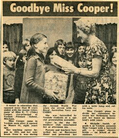
Memorabilia - Newspaper clippings, Miss E.V. (Vida) Cooper retirement - Teaching career included Mitcham and East Ringwood Primary Schools, Victoria
Vida Cooper's first teaching post was Ringwood East Primary School, Everard Road. Clippings included with Cooper Collection memorabilia donated by Annette Rattray - a distant relative.Newspaper clipping circa 1975 headed Goodbye Miss Cooper and 1942 clipping of cattleyard scene.1. Michelle Smith of grade 6 at Verdale Primary School, Mitcham, presents Miss Cooper with a farewell gift - a copper electric kettle - on behalf of the students. 2. Wednesday, March 11, 1942 - Helping with the branding: Two city girls helping with the branding on Mr. John Roper's property, Mt. Yorke, Tawonga, via Wodonga. -
 Federation University Historical Collection
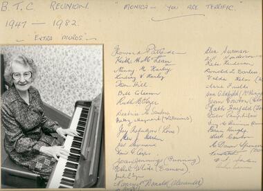
Photograph, Monica Miller photograph, BTC Reunion 1947 - 1982
Monica was a well-loved music teacher at the Ballarat Teachers' College.Black and white photograph in cream matte board. Monica Miller sits at the piano. Those who attended the BTC Reunion 1947 - 1982 signed the mountballarat teachers' college, monica miller, lynette vickery (lynch), beth stutterd (leslie), howard pattender, keith h. m. lean, nancy m. harley, lindsay w. harley, jon hill, bill gleeson, ruth b gozer, beatrice m. sanders, betty maynard (williams), joy anderson (love), stan j marlen, wal maynard, david g. cooper, joan jennings (gunning), etherl white (esmore), jack ..., nancy mcdonald (alexander), pat watts (knight), lorna davis (welsh), joyce fraser (mathison), hugh fraser, margaret alexander (palmer), maurene canter (merlin), elva surman, bill henderson, reta henderson, ronald l. earless, valda kelm (witney), marie faulds, ann oldfield (mckinnen), jean cowton (clode), kath harfield (tobin), groen pamphilon, inez m bemirs (domascheng), bernie kurght, mick cowton, m. dawn spencer (doney), vern white, n.t. sanders, arther ..., -
 Federation University Historical Collection
Minute Book, Eureka Stockade Memorial Park Committe Minute Book 2, 1919 - 1924
Black cloth covered book with red tape spine. Handwritten minutes of the Eureka Stockade Improvement and Progress Associationeureka, eureka stockade, stockade, committee, eureka sports, george williams, kite flying, ballarat and rebekah lodge, a cochrane, f britnell, lake penhalluriack, helen, mckay, eureka tile company, corner in blighty, buttler, george lakeland, j corbett, b cooper, w elsworth, r britnell, f pearsej f corbett, groves, a cooper, eureka anniversity, eureka monument, eureka carneval, swimming, crago, nowatt, scholes, j dynan, b grove -
Federation University Historical Collection
Album pages, Photographic Biographies of former 1947 Ballarat Teachers' College students
Gathered over the years as the result of Ballarat Teachers' College reunions.Pages from a large photograph album with photographs and handwritten reminiscences relating to students at the Ballarat Teachers' College in 1947. .1) Athol Aisbett .2) Nance Alexander, Jess Batson, Eddie Blake .3) Phyllis Borley .4) Keith Boyd .5) Owen Brennan, Josie Bunney, Ron Carless .6) David Cooper .7) Inez Domaschenz .8) Jean Clode, John Collins, Colin Collins .9) Dawn Doney, Fay Dreher .10) John Ellison, Ethel White .11) Hugh Fraser, Joyce Mathison .12) Marie Faulds, Robert Giddings .13) Val Gorrie, Bill Gleeson, Joan Gunning .14) Bill Henderson .15) Pat Luxford .16) Tom Hill, Nancy Kerr, Lindsay Harley .17) Keith McClean .18) Claire Kennedy, Keith McLean .19) Ann McKinnon .20) Maurine Merlin, Joyce Kennedy .21) Fred Marshman .22) Howard Pattenden .23) Milton Rice .24) Mayvis Poland, Bill Punshon .25) Pat Robinson .26) Pat Watts .27) Betty Williams, Jim Williams .28) Lorna Welsh, Neila Vallance .29) Kath Tobin, Jack Tyers .30) Burns Roddis .31) Howard .32) Owen Brennan .33) Colin Connelly .34) Jack Mallett .35) Black display book of correspondence and death notices relating to former 1947 Ballarat Teachers' College Students -
 Federation University Historical Collection
Certificate, Eureka Stockade Improvement & Progress Association Past President's Certificate, 06/07/1922
A paper based certificate in browns, gold and blue glued to a brown mount. The certificate was presented to A. Cooper.Handwritten onto the certificate "A. Cooper" "June 2nd 1921 to May 31st 1922" "W.J. Groves" "H. Britnill" "6/7/22"eureka stockade, a cooper, wj groves, h britnill, eureka stockade progress asociation, eureka stockade and progress association -
 Federation University Historical Collection
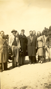
Photograph - Photograph - Black and White, Ballarat Teachers' College Picnic, 1947, 1947
The Ballarat Teachers' College had a number of excursions and events including the college picnic.Two black and white photographs of Ballarat Teachers' College students at a picnic. .1) nine adults pose for a photograph. All are standing. .2) Three males 'play rough' on an oval..1) - verso "College Picnic" .2) - verso "Sammy Boyd, David Cooper (Charles), Tom Hill. College picnicballarat teachers' college, boyd, cooper, hill, picnic, student activity -
Federation University Historical Collection
Book, Journal pertaining to BORES Berry Mines
This book is associated with former Ballarat School of Mines Student Richard Squire (1875-1876). Gift of the Squire FamilyGreen water marked linen covered journal with maroon spine with red feint lined blue pages. Label on front cover is cream with black printing JOURNAL with handwritten BORES. Hand written in black ink. Plans of shafts throughout 182 pages.Map/plan loose at page 48. Index on pages 176 - 181Bores written on front cover berry consols, bores, gold, gold mining, mining, shafts, g. maryhans, charlesons, davies, coopers, west berry consols gold mining company -
Federation University Historical Collection
Book, A History of American Mining, 1932
This book was presented to Charles Bacon by Seeley Wintersmith Mudd.Red hard covered book of 419 pages in the A.I.M.E. Series (American Institute of Mining and Metallurgical Engineering Inc). It includes a presentation Bookplate from Seeley Wintersmith Mudd made out to Charles Bacon. Chapters include mining in the far north, Comstock Lode, Colorado, Mississippi Valley, Great Salt Lake, Black Hills of South Dakota, Cooper of Lake Superior, copper in Arizona, Bunker Hill Enterprise, Butte The great Diamond Hoax, Flotation Process. The book includes some simple maps and plans. The book was dedicated to 'The most distinguished of American mining engineers Herbert Hoover'.t.a. rickard, herbert hoover, seeley wintersmith mudd, bookplate, charles bacon, mining, america -
Federation University Historical Collection
Image, Ballarat Teachers' College students and staff, 1947
This image was used by the Ballarat Teachers' College Class of 1947 during their reunions. black and white laminated phiotocopied photograph of men and women in front of brick building, with names typed underneath. Surnames are: Howlett, Rice, McLean, Williams, Nield, Cooper, Terrill, Gleeson, Pascoe, Harley, Carless, Giddings, Connelly, Magill, Blake, Punshon, Aisbett, Collins, O'Shannessy, Leslie, Dreher, Pamphilon, Lelean, Pattenden, Tyers, Fraser, Henderson, Mallett, martin, Boyd, Ellifson, Collins, Hill, Henning, roddis, Marshman, Doney, Watts, McKinnon, Esmore, Love, Luxford, Elliott, Bunney, Borley, Mathison, Domaschenz, Hannan, Perry, Merlin, Batson, Witney, Tozer, Kerr, Tobin, Morrish, Clode, Purdue, Kennedy, Palmer, Faulds, Ritchie, Lewin, Poland, Welsh, Lynch, Alexander, Williams, Gorris, Sonsee, Miss Kentish, Bryan, Miss Miller, Lord, Miss Hughes, McEwin, Miss Hayes, Vallance, Robinson, Surman, Gunning, Dally, Freeman, Crossettballarat teachers' college, lindsay harley, nancy cooper, david cooper, dana street primary school, alan sonsee, dana street state school -
 Federation University Historical Collection
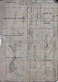
Plan, Underground Survey of Mines, Ballarat District, Creswick and Kingston Mines, 1888, 06/1888
This plan is associated with former Ballarat School of Mines Student Richard Squire (1875-1876). Gift of the Squire FamilyA paper plan on linen showing the following mines: Australasian Extended, North Australasian, Davis and Charlesons Amalgamated, Davies Junction, Dykes N.W., Coopers, F & L Holding, New Australasian, Australasian and Eaglehawk, BrawnsWritten above Australian Extended "West Berry Consols Coy" Written near Davis' and Charlesons Amalgamated "West Berry Consols Coy"creswick, kingston, berry, australasian, plan, mining, robert allen, richard squire -
 Federation University Historical Collection
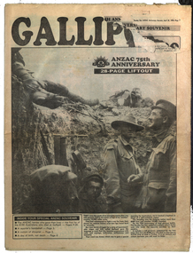
Newspaper Supplement, The Sun ANZAC Anniversary Souvenir, 22 April 1990, 22/04/2015
25 April 1915 is the date that the ANZAC troops landed at Gallipoli during World War One. After that year it has been commemorated as ANZAC Day.28 pages newspaper supplement relating to the 75th anniversary of the Gallipoli landing by the ANZACs during World War One. The supplement includes: List of 8100 ANZAC heroes who died at Gallipoli (pp 9-20), Keith Murdoch and his Gallipoli letter; Diary of Gallipoli Digger Apear Leslie de Vine, ceasefire for burial; Turkish soldiers; Simpson and his Donkey; Albert Henry Gayden's diary; Gallipoli nurses; Burial for a Lost Digger; Chunuk; Names of those who went to Gallipoli for the 70th anniversary An article by Geoffrey Blainey is headed 'A day not of death, but birth'. He states that Able Seaman Williams is the first Australian to be killed in action in the 1914-1918 war.james monro, john laffin, ian hamilton, keith murdoch, andrew fisher, ross bastiaan, albert jacka, leonard keysor, wiliam symons, alexander burton, william dunstan, frederick tubb, john hamilton, alfred shout, hugp throssell, albert gayden, ella tucker, bill cooper, jim douglas, walter parker, bob ponsford, tom meagher, claude franhauser, roy kyle, edmund thompson, jim kibble, robert barclay, roy longmore, jim lees, george fullerton, tom neal, stanley quinn, world war one, gallipoli -
Federation University Historical Collection
Poster, Ballarat School of Mines Staff Photos, c1988
Laminated black and white photographic portraits of Ballarat School of Mines staff members.xballarat school of mines, ian aitken, anne wood, roger macfarlane, des cooper, malcolm vallance, mal vallance, lyn pitt, floss stephenson, shane everard, lily saylor, linda bland, lyndall cooper, don doulton, julie baulch, peter gunn, malcolm gaunt, steven medelson, jan reeves, trevor slater, tracey cummins, ray martland, ann kerr, kieran jones, mandy rhook, john gibson, iam pym, patti mcnulty, janice shepherd, lindy hamill, bob feary, philip dixon, ron lucas, glen mcgregor, gordon whitefield, david fithall, bill bridges, doug symons, keith howlett, bernie stevens, norm howard, ray barnes, peter kelly, garry christie, paul clarke, robert munt, shaun tope, james mddonald, graeme tyrell, bruce wallis, tracey coleman, bradley rae, phillippe theatre, don lawless, bill whittle, geoff nicholls, maureen carli, keith boast, fiona watson, sonia davis, manfred hacker, ian robinson, jeff fletcher, angela murray, angela smith, lyn peucker, rosemary moorhouse, keith hankin, judy mills, brian webber, jan o'toole, veronica black, fleur haller, lorelli huggins, karen cook, len wilson, bruce staley, lynne beaumont, dzintra crocker, faye hunt, leonie hines, sally smith, jenny leviston, heather durant, barrie firth, john van dreven grant curnow, ron sutton, lynne schepis, pam merrett, fran harrison -
 Federation University Historical Collection
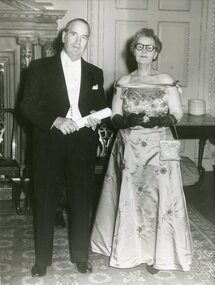
Photograph, Frank Wright, Laura Wright (Ritchie) and Martin Cooper, 1960, 1960
frank wright, laura wright, laura ritchie, martin cooper -
 Federation University Historical Collection
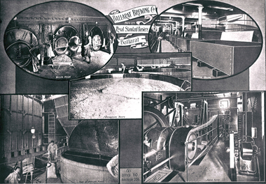
Photograph - Photograph - Black and White, Ballarat Brewing Company
Copies of images relating to the Ballarat Brewing Company.ballarat brewing company, cooper, brewing, brewery -
 Federation University Historical Collection
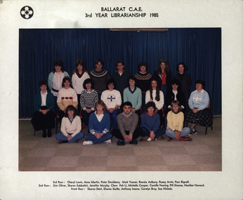
Photograph - Photograph - Colour, Ballarat College of Advanced Education 3rd Year Librarianship, 1985, 1985
Colour photograph of Ballarat College of Advanced Education 3rd Year Librarianship student at Mount Helen Campus. Back Row: Cheryl Lewis, Anne Martin, Peter Stutchbery, Mark Vanner, Brenda Astbury, Rosey Arnts, Pam Bignell 2nd row: Erin Oliver, Sharon Sabbatini, Jennifer Murphy, Chew Poh Li, Michelle Cooper, Camille Vearing, Fifi Stamos, Heather Howard Front Row: Sharon Dent, Dianne Guille, Anthony Insana, Carolyn Bray, Sue Nicholscheryl lewis, anne martin, peter stutchbery, mark vanner, brenda astbury, rosey arnts, pam bignell, erin oliver, sharon sabbatini, jennifer murphy, chew poh li, michelle cooper, camille vearing, fifi stamos, heather howard, sharon dent, dianne guille, anthony insana, carolyn bray, librarianship, sue nicholls, ballarat college of advanced education -
Federation University Historical Collection
Booklet, Ballarat School of Mines Student's Magazine, Second Term, 1903, 1903
Table of contents: Editorial, Bad language in Sturt Street, The Greatest Mining Camp on Earth, A method for estimating arsenic in ores, S.M.B. camp, Some engineering experiences, Some reminiscences of W. A., Science notes, Notes on Mt Lyell, Students afield, Estimation of titanium, Illustration - students' abroad - No. 1, Past students, Ballarat scientific and literary society, Students' reunion, News and notes, Special notice, A sentimental ditty, International atomic weights. Pale gray booklet of 20 pagesballarat school of mines, students' magazine, o. e. jager, obituary, alfred gersham johnston, w. b. blyth, s. b. vial,, d. w. b. arthur, s. radcliffe, r. j. allen, tom vincent, angus gibson, lew westcott, reg robin, r. a. suter, b. nicholls, cecil eeles, gerald young,, harold edgar, fred cooper, h. l. krause, len seal, r. m. stubbs, dave lilley, e. w. trend, austin woods, j. phillipson, j. brangan, e. prendergast,, w. j. lakeland, w. a. gosman, a. basil reid, students' reunion, alfred mica smith, dr salmon, j. b. pearson, e. shew, j. m. currie, h. alston,, h. irwin, f. j. martell, a. m. ritchie, professor dawbarn, a. m. ritchie, t. s. hart, j. a. reid, a. e. kerr, a. gillespie, thomas hart, frederick martell -
Federation University Historical Collection
Document - Reports, Large Cats, Thylacenes and Large Predators Sigtings, 1975-1985 and 2002-2011
The folder of correspondence is the result of a Freedom of Information request made to the Department of Sustainability and Environment in 2011. The folder was collected for research being conducted by David Waldron.Folder of correspondence and newsclips relating to "Big Cats" and other large predators. Please note: sections of this file are closed to protect the privacy of correspondents.australian mythical animals collection, david waldron, brian waters, moonambel, joyce collins, ian smith, thylacene, marrarkuli, burragorang, m.g. hornocker, mt bepcha, billywing upland, john a. henry, bryan wlaters, ken bodinnar, harcourt, kevin farley, fowlers bay, carolyn hodges, puma, macarthur, paynesville, john aldreson, animal damage control, mountain lion, bryan walters, cougar, big cat, maryborough, joan kirner, bernard mace, tasmanian tigers, d.g. willey, calder highway sightings, kevin phelen, mt richmond national park, feral cat, felis catus, lancefield, pyalong, broadford, pyalong pantherleopard, porsche park, dick shaw, big cats in victoria, peter hall, lyn sellens, south gippsland, plaster cast, foot cast, unidentified wildlife, john seeback, michael moss, carnivores, halls gap, halls gap puma scats, kooreh, ballan, ballan large cat, a.g. kerr, south gippsland tasmanian tiger sightings, central victorian puma, otways, wilsons promontory, john higgins, tasmanian wolf, j.k. depmster, vermin, lion, cooper's creek, warrego river, dingo, thylacinus cynocephalus, mirboo north, newham, operation puma victoria, australian skeptics, kangaroo ground, rare fauna, black wildcat, pyalong panther, bob warneke, black puma, maryborough puma, creswick panther, cape bridgewater, pyrenees panther, footprints, daisy hill, bung bong, phantom puma, geranium springs, maurice hornocker -
 Federation University Historical Collection
Document - Folder, Brewing
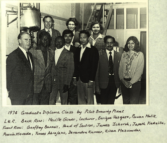
Folder containing the History of the course in Brewing at Federation University. brewing, neville gower, enrique vazquez, pawan malik, geoffrey barrell, james ichorol, japath kadzitu, pravin mevada, tomas abrajano, devandra kumer, kiran mazumbdar-shaw, australian beer awards, judges, stewards, ballarat college of advanced education, food technology, charles hulse, john harvey, warren cooper, mark bradby, john fuenell, frank heley, len peters, beer -
 Federation University Historical Collection
Magazine, Ballarat School of Mines Students' Magazine, 1947, 1947
The Ballarat School of Mines was a predecessor institution of Federation University Australia. Yellow front page soft cover of 55 pages with green and blue inscriptions on front cover Artwork Mr Bryan - By Peter Wilson Original book illustration - By Peter Wilson Hammerhead - By Peter Wilson Yank - By Joan Parker Herb - By Peter Wilson Tex - By Stanley Butson Rex - By Marjorie Gray Pen and Ink rendering - By Norman Whittaker Bet - By Evelyn or John Robinson Original Book Illustration - By William Ross Spud - By Marjorie Gray Dell - By Evelyn or John Robinson Fay - By Marjorie Gray Hazel - By Maurice Collins Thelma - By Ian Cooper Mickey - By Peter Wilson Wardy - By David Daykin Tiny - By Joan Parker ballarat school of mines students' magazine, staff, sports, james rogers, dr pound, mr procter, mr r. w. richards, mr h. j. edwards, mr r. p. flower, ken palmer, joan walter, mr john leslie burt, mr fisher, mr pattenden, mr scarfe, mr a. m. richards, mr j. woolcock, mr p. marxsen, obituary, mr david maxwell, a. f. heseltine, dorothy spence, p. wilson, n. whitaker, william ross, peter wilson, joan parker, stanley butson, david daykin, ian cooper, june baker, hazel barry, lesley bearup, winifred beckwith, david berlyn, william bolitho, daniel brazil, lawrence burchell, william bates, ronald cairns, leslie coburn, maurice collins, kenneth cowell, john dixon, francis eckermann, rexford fraser, elizabeth freeth, eric goon, marjorie gray, doreen hehir, joyce hicks, john lannen, stanley lawrie, charles layfield, ethel lloyd, robert looney, eileen maloney, gwendoline mcdonnell, ian mclenehan, colin nicol, mervyn oddie, john procter, shirley ross, frederic reeve, evelyn robinson, john robinson, graeme ross, ronald rosser, jean scott, lawrence sedgwick, john shergold, margaret sim, clifford skurrie, norma stafford, barbara strachan, iris sherritt, robert tantau, anthony tunbridge, clive venables, dorothy waller, wesley walters, harold ward, john willis, norman whittaker, ballarat school of mines football team, j. rogers, j. willis, hans fumberger, dave jelbart, j.mccoy, m. heatherington, mr hillman, r. rosser, bob davis, r. kibby, c. edmonds, j. blainey, w. brown. r. cairns j. morrish, k. whiter, a temby, b. tantau, n. rees, b. murrel, l. veale, robert davis