Showing 75 items
matching mt dandenong north
-
 Ringwood and District Historical Society
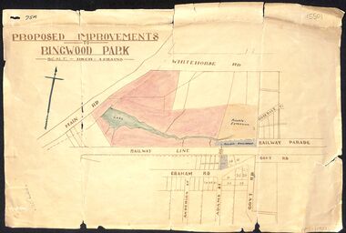
Map, Proposed Improvements to Ringwood Park (Ringwood Lake) dated 14 January 1927
Proposed Improvements to Ringwood Park (Ringwood Lake) dated 14 January 1927, signed Cr McCaskill. Main Road is Whitehorse Road (Maroondah Highway), and Mt Dandenong Road is incorrectly labelled Whitehorse Road. The map shows Rosedale Crescent and Railway Parade, both of which exist in 2024. On the bottom of the map, south of the railway line, showing proposed streets - Graham Road, Anderson Street and Adams Street - in preparation for the sale of the Theo Anderson property. That area is now Bedford Park. -
 Ringwood and District Historical Society
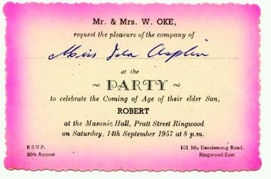
Photograph, Invitation from Mr and Mrs W Oke (101 Mt Dandenong Road, East Ringwood) to celebrate son Robert ("Bob") on his 21st at Ringwood Masonic Hall, Pratt St, Ringwood 1957
Scanned on 30th January, 2008 from Ida Oke's albums. Ida lives in East Ringwood and also contributed to the East Ringwood Recollections book. Wife of Bob (Robert William) Oke. Both Ida and Bob were heavily involved in the Scout movement, as were Bob's parents - Corrie and Ruby (Guides) Oke, who both lived in Old Lilydale Road, East Ringwood. -
 Mt Dandenong & District Historical Society Inc.
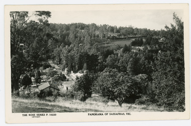
Photograph, Panorama of Sassafras, Vic, c1950
Panorama of Sassafras in the 1950s taken from Wallaby Avenue looking down onto the Sassafras Cabaret building. Rostrevor can be seen at centre top.Black and white Rose Series postcard P. 10220 showing a view from high down the Main Street of Sassafras looking north towards Olinda.On reverse POST CARD. A Real Photograph. Produced in Australia.rose series, postcard, sassafras, cabaret, wallaby avenue, rostrevor -
 Mt Dandenong & District Historical Society Inc.
Photograph
Jim Keogh owned Lot 7 of the Village Settlement. When the new CRB road went through c1920 his block was cut through leaving a small triangle of land on the high side of the CRB road. He built a shop on this piece of land. The store burned down 31/12/1939. The woman on the step in this photo is Win Woodcock.Sepia image of a woman standing in front of a wooden store. Handwritten inscription on reverse by John Lundy-ClarkeJim Keogh's shop on the north west corner of Falls and Main Roads. Opposite diagonally from St Michael's Church of England. photo Nov 1926.jim keogh, keogh, store, shop, crb road, win woodcock -
 Mt Dandenong & District Historical Society Inc.
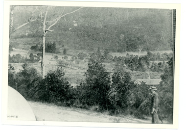
Photograph
... from Mt Dandenong Road, Montrose about 275 metres north ...This photograph was taken c1908 and shows the view from Mt Dandenong Road, Montrose about 275 metres north of Sheffield Road.Black and white photograph showing a man in a white hat walking up a dirt road wth bush a nd a house roof to his right.mt dandenong, montrose, sheffield road -
 Mt Dandenong & District Historical Society Inc.
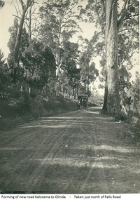
Photograph, Forming Of New Road Kalorama To Olinda, early 1920s
The new Main Road, now Mt Dandenong Tourist Road, was completed in 1926. This scene is looking towards Montrose down from the intesection of Falls Road.Scene of wagon drawn by two horses on wide dirt road with large trees on side of road. Taken just north of Falls Road.wagon, road, main road, mt dandenong tourist road, falls road, horse -
 Mt Dandenong & District Historical Society Inc.
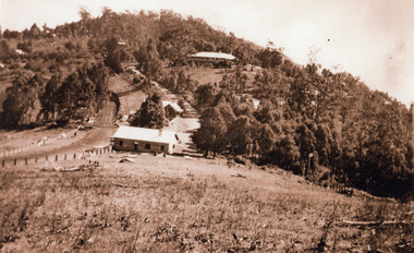
Photograph, 1920s view of Kalorama FiveWays, c1920
North view Mountjoy complex, Post Office and Store at FiveWays. Mountjoy Guest-house on hll with Jeeves Coach Service.Black and white photograph looking up hill towards guest house with two smaller buildings clearly visible in foreground and several roof tops in distance.ellis jeeves, fiveways, guest house, jeeves, mountjoy, post office, coach service -
 Mt Dandenong & District Historical Society Inc.
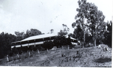
Photograph, Mountjoy Guest-House
Mountjoy Guest-House showing north and west aspect. The guest house was run by the Jeeves family from 1908 to c1943. After the death of her husband Ellis in 1921, the guest house was run by Eliza Jeeves (nee Hand).Black and white photograph showing large guest house building with gum trees at the side and a cleared area in front. A single chimney is visible.guest house, mountjoy -
 Mt Dandenong & District Historical Society Inc.
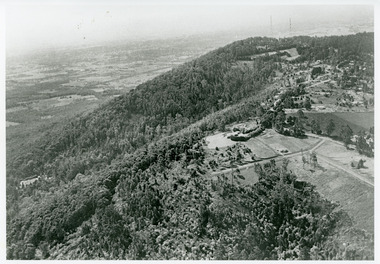
Photograph, View Towards Mt Dandenong 1961, 1961
... Looking north towards Mt Dandenong 'City Lights' estate... Estate Looking north towards Mt Dandenong 'City Lights' estate ...Looking north towards Mt Dandenong 'City Lights' estate 1961. Viola Court in foreground, Ridge Road winding up the hill towards the Observatory.mount dandenong, ridge road, viola court, city lights estate -
 Mt Dandenong & District Historical Society Inc.
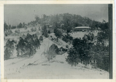
Photograph, Kalorama Gap Under Snow 1921, 1921
View of Kalorama Gap under snow taken in 1921. Mountjoy Guest House is at top right and Beulah Tea Rooms is in the centre. This photograph has a detailed inscription on the back handwritten by John Lundy-Clarke in 1974.Kalorama Gap under snow 1921 The leafless elm trees are low in the centre and the dual nature of the nearer one can be clearly seen, two small suckers of the older farther tree being twisted together in 1898 by Fred Jeeves. The older tree was planted 1880. Mrs Hands shop can be clearly seen, which was the Mount Dandenong North Post Office. The old Main Road runs up the centre of the picture and turns to the right and disappears behind “Mountjoy” the big guest house built by Paynters in 1905 and sold to Ellis Jeeves 1908, whose family ran it till 1943. At the bend of the road behind the big pine tree and the dark blackwood can be seen faintly the gable of Price’s house that contained the first shop on the mount. Above it is H Walker’s cottage on Ridge Road that still exists, his homestead is on the left of the picture on the same level. Below this house and to the left can be seen Ted Prices hay and corn store. The present estate agency lies between these two buildings, on the road which had recently been built. This can be seen winding from the lower left corner of picture to the left of the elms. The CRB had recently fenced the road and this is clearly seen as it circles behind trees in the left centre. Barber’s Road crosses CRB Road to the left of the dray under the leafless elm and the Coach Road dives down to the right just behind the pair of blackwoods to right of the elms. The picture was taken from just above the boundary of Isaac Jeeves’s selection Crown Allotment “C” (Jeeves Saddle) which stretched across the Gap to the other side of Mrs Hand’s shop, monopolising the gap from 1871 to 1879. Price’s house remains partly as the small house – “Mirra Laken”. kalorama gap, fiveways, post office, mountjoy, guest house, snow -
 Southern Sherbrooke Historical Society Inc.
Draft Precinct Brochures - Shire of Yarra Ranges, "Shire of Yarra Ranges Neighbourhood Character Study"
Collection of Draft Precinct Brochures in ring binder prepared by the Shire Of Yarra Ranges for public comment. Areas include: Belgrave, Coldstream, Chirnside Park, Healesville, Kilsyth, Lilydale, Monbulk, Montrose, Mooroolbark, Mt. Evelyn, Seville, Seville East, Tecoma, Upwey, Wandin North, Warburton, woori Yallock, Yarra Glen and Yarra Junction. -
 Mont De Lancey
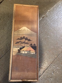
Pencil Case
Nancy Gaudion AdeneyWooden pencil case with compartments. Hinged wooden lid wiht Japanese style illustration of Mt Fuji."Made in Japan" stamped on the rear of the pencil casepencil cases -
 Mont De Lancey
Book, E.W. Cole, Sketches by Boz
Charles Dickens' first published book, Sketches by Boz is a funny and touching observation, fancy and fiction showing the London he knew in all its complexity - its streets, theatres, inns, pawnshops law courts, prisons and of course the river Thames.A small faded green hardback novel, The Sketches of Boz by Charles Dickens. The front cover has no title but the spine has faded gold lettering of the title, author and publisher as well as decorative symbol. 558p.At the front is a page with an inscription in black ink handwriting and a date.fiction Charles Dickens' first published book, Sketches by Boz is a funny and touching observation, fancy and fiction showing the London he knew in all its complexity - its streets, theatres, inns, pawnshops law courts, prisons and of course the river Thames.books, fiction books, historical fiction -
 Eltham District Historical Society Inc
Photograph - Digital Photograph, Marguerite Marshall, Jelbart home, 93 Arthur Street, Eltham, 11 November 2006
Situated at the top of the hill in Arthur Street, the former Jelbart residence and barn were part of a major change that transformed Eltham's character in the late 1960s. Built from the mid 1940s through mid 1950s when Eltham was a rural community, the Jelbrat residence and barn are all that remain of a family property of some 250 acres (100 ha). With growing population pressures, in the late 1960s, owners Ron and Yvonne Jelbart decided to subdivide their property creating the Woodridge Estate in the early 1970s, a major factor towards the transformation of Eltham to the suburb it is today. The Jelbarts had moved to Eltham in the early 1940s when they purchased a poultry farm in New Street, now Lavendar Park Road. (The local Black Friday bushire of January 13, 1939 had started at C.A. (Clarrie) Hurst’s Eltham Poultry Farm and Hatchery in New Street.) Jelbart was primarily a businessman importing office machinery but desired farm beef and dairy cattle so the couple purchased the virgin bushland at what was then at the end of a dirt road, Arthur Street. With post war shortages of most building materials, they followed the example of the Eltham Artists' Colony (later called Montsalvat) and built thier home from mud-bricks and recyclked materials. The barn was first to be completed in 1945 which they made their home whilst building the main residence. It took eight years to complete the two buildings. Both the main residence and the barn are now separate homes, and along with the remaining property being sub-divided further in 1998 are now part of the Kinloch Gardens Estate at 93 Arthur Street. Covered under Heritage Overlay, Nillumbik Planning Scheme. Published: Nillumbik Now and Then / Marguerite Marshall 2008; photographs Alan King with Marguerite Marshall.; p139 Standing on a hilltop at Arthur Street, Eltham, the Jelbart residence and former barn were part of a major change that transformed Eltham’s character in the late 1960s. Built from the late 1940s to the mid 1950s when Eltham was a rural community, they are all that remain of what was once a family property of around 250 acres (100 ha). As population pressure increased in the late 1960s, owners Ron and Yvonne Jelbart, decided to subdivide their property. The break-up of this property into the Woodridge Estate in the early 1970s, was a major factor towards transforming Eltham into the suburb it is today.1 Although standing only a few minutes from Eltham’s busy hub and hundreds of houses in Woodridge, scarcely any urban sound disturbs the peace. Views from the two buildings are almost exclusively of trees and extend to Mt. Dandenong to the south-east, the Great Divide to the north, and Melbourne city to the south-west. The Jelbarts had lived in Eltham since the early 1940s when they bought a poultry farm in New Street, now Lavender Park Road. Although Jelbart was primarily a businessman importing office machinery, he was keen to farm dairy and beef cattle, so the couple bought rough bushland at what was then the end of Arthur Street. But a shortage of building materials following World War Two hampered their plans to build their new home, so they followed the example of the Eltham Artists’ Colony (later called Montsalvat) and used mud-bricks and recycled materials.2 With great determination the family and friends constructed their house. Massive timber frames and huge quantities of mud-bricks were made on site. The barn was built first in 1945, and two years later, while camping inside, the Jelbarts started building their house. It took eight years to construct the two buildings, even with the help of professional tradesmen. The buildings, with timber frames infilled with mud-brick and plastered, are reminiscent of the English Tudor style. The Jelbarts are of Cornish stock. Much of the timber framework came from demolished bridges or warehouses, and recycled slate was used for roofs and floors. Quality second-hand materials were readily available in the late 1940s and 1950s when there was much demolition in Melbourne and little respect for heritage. A former 19th century Toorak mansion Woorigoleen provided the magnificent stone fireplace, the timber panelling and the parquetry floor in the living room. The large stone gateposts at the entry of the property came from Melbourne University. Almost no mechanical equipment was used to build the 55 square house and the 25 square barn. Massive timber frames were erected using block and tackle pulleys and timbers were shaped, sawn and drilled by hand. Son and architect Ian, with his family, have lived in and extensively renovated both buildings since the early 1970s. Ian transformed the steep ridge of the property into a plateau, where the main house Kinloch stands, surrounded by terraces and lawns. The grounds retain many native plants, including massive yellow boxes – some nudging 80 years. Ian attached 70 metres of pergolas draped with wisteria, roses and grape vines, to three sides of the house. The beautiful garden is featured in the book Through the Rose Arbour by Rosemary Houseman. The two-storey barn – now a house – retains traces of its original use. The cow-shed with milking and feed-rooms, and the machinery-shed remain. The house, separated on the ground floor by a breeze-way, soars two storeys and includes a mezzanine. These are connected by spiral staircases, to timber-beamed and plaster-lined high-pitched ceilings. The house also descends to a wine cellar. Curiously the roof is of corrugated iron on the south and slate on the north, to save costs. Small-paned windows and three French doors open onto the front lawn, which extends to Jelbart Court.This collection of almost 130 photos about places and people within the Shire of Nillumbik, an urban and rural municipality in Melbourne's north, contributes to an understanding of the history of the Shire. Published in 2008 immediately prior to the Black Saturday bushfires of February 7, 2009, it documents sites that were impacted, and in some cases destroyed by the fires. It includes photographs taken especially for the publication, creating a unique time capsule representing the Shire in the early 21st century. It remains the most recent comprehenesive publication devoted to the Shire's history connecting local residents to the past. nillumbik now and then (marshall-king) collection, eltham, arthur street, jelbart barn, jelbart home, kinloch gardens -
 Kiewa Valley Historical Society
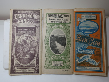
Maps - Tourist
These maps were all dated 1933 which was before the construction of the Kiewa Hydro Electric Scheme and when Tawonga was spelt Towonga. North East Victoria in 1933 was before the construction of the Kiewa Hydro Electric Scheme so the townships of Mt Beauty and Bogong are not shown. The description of the Snow Lines was important as skiers, bushwalkers and campers relied on them. The details on the map include "ADB. Numbered from A.1-377 round plates. CD Numbered from C 1-235 square plates. Poles about 3 chains apart 27 to the mile." 3 Tourist location maps (folded) and printed on parchment. 1. Tourist map of the Dandenong Ranges. Brown cover. dated 6-4-33. Govt. printer showing roads, tracks in red and heights of the land. 2. Tourist Map of Warburton, Mt Baw Baw, and Walhalla. Blue and Orange cover. dated 23-5-33 Govt. printer. 3 different maps of each area showin roads, tracks and timber tramways.Also in red and blue. 3. Tourist Map of North Eastern Victoria including Bogong High Plains Mt Buffalo Etc. Green cover. dated June 1933 Govt. printer. Main map and insert titled Bogong High Plains. Showing roads , tracks and tram ways. On insert showing snow poles. Also Red and Blue and mountains.By Authority of H.J. Green - 6 pence. Dept of Lands and Survey, Melbourne1933 maps, tourism maps, bogong high plains map 1933, snow poles