Showing 613 items
matching mt helen library plan
-
 Federation University Historical Collection
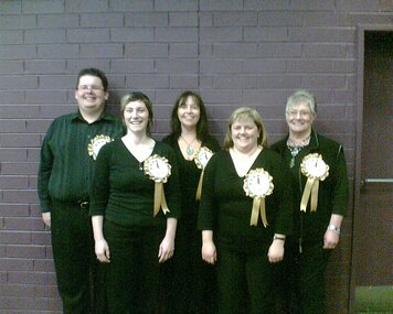
Photograph - Colour photograph, Greg Eames, University of Ballarat Libary and Information Technology Services Planning Day, 2007
A number of photographs of activities during Planning Daylibrary planning day, its planning day, greg eames, nancy lange, library, jill nicholls, carmel grant, gaida stevens, john dixon, ash pinder, trevor day, julie lasinger, treacey wilson, aaron quarrell, andrew matheson, kim redfern, sam pitman, emily eames, ann jardine, pam goodfellow -
 Federation University Historical Collection
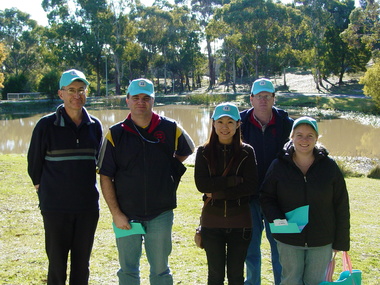
Photograph - Colour photograph, Greg Eames, University of Ballarat Library and Information Technology Services Planning Day, 2006
A number of photographs of activities during Planning Daylibrary planning day, its planning day, greg eames, nancy lange, library, jill nicholls, carmel grant, gaida stevens, trevor day, treacey wilson, andrew matheson, sam pitman, emily eames, pam goodfellow, frank russell, leeanne pitman, bill casey, arno besso -
 Federation University Historical Collection
Programme - Printed Programme, The School of Mines and Industries Ballarat Tour of Inspection
Four page programe for a Tour of Inspection of the Ballarat School of MInes. The tour included the Administration Builidng, E.J. Tippett Hall (former Wesleyan Church), Trade Workshops, Hickman Street, Army Huts (BCAE Art), Armstrong Street Vehicle Repair Trades, Electrical Trades. SMB Art, Battery (BCAE Pottery and Art), New Library Building (E.J. Barker Library. A map of the tour is given, and a development plan.ballarat school of mines, art, battery building, pottery, hickman st, trade workshops, e.j. tippett hall, map, plan -
 Federation University Historical Collection
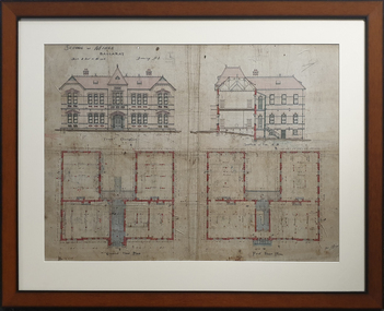
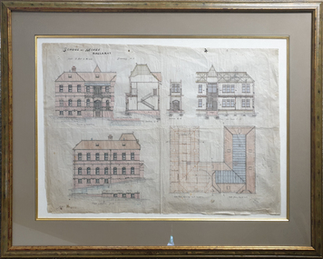
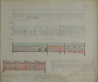
Plan, Architectural Plan for the Ballarat School of Mines New Classrooms, 1899
Framed original plan of the Ballarat School of Mines New Classrooms (later called the Administration Building). The plan includes a front elevation, a gound floor plan, first floor ground plan, and a section on line. ballarat school of mines, architectural plan, administration building, new classrooms -
Federation University Historical Collection
Plan - Architectural Plan, Architectural Plan for the Front Elevation of the Ballarat School of Mines New Classrooms, 1899
Framed original plan of the fron televation of Ballarat School of Mines New Classrooms (later called the Administration Building). ballarat school of mines, architectural plan, administration building, new classrooms -
Federation University Historical Collection
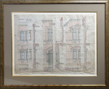
Plan - Architectural Plan, Architectural Plan for the Back and Flank Elevation of the Ballarat School of Mines New Classrooms, 1899
Framed original plan of the back and flank elevation of Ballarat School of Mines New Classrooms (later called the Administration Building). ballarat school of mines, architectural plan, administration building, new classrooms -
Federation University Historical Collection
Programme - Leaflet, Opening of the New Ballarat School of Mines Laboratory, 23/05/1902
Arudent ushers for the event wore white rosettes.Four page progranne for the opening of the Ballarat School of Mines New Mining Laboratory by the Minister of Mines, J. Balfour Burton. It includes a plan of the Ballarat School of Mines Buildings and demonstrations withing each. ballarat school of mines, new mining laboratory, buildings, demonstrations -
 Federation University Historical Collection
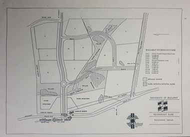
Plan, Ballarat Technology Park plans, c1998
.1) Alotment plan .2) contour planballarat technology park, mount helen campus, canadian wetlands, ballarat to buninyong railway line, sub-division layout -
 Federation University Historical Collection
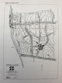
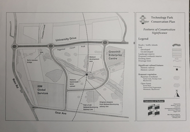
Map, Matthew Cibson, University of Ballarat Centre for Environmental Management, Ballarat Technology Park Conservation Plan, 1997, 02/1997
The Ballarat Technology Park is on the Federation University Mount Helen CampusMap showing the Ballarat Technlogy Camp, Greenhill Enterprise Centre, Canadian Wetlands. hand-made brick culvert sleepers, Ballarat-Buninyong Railway Line, IBM Global Services, early wooden bridge, Canadian Creek, Gear Avenue. ballarat technology park, canadian wetlands, greenhill enterprise centre, brick cultert, railway, ballarat-buninyong railway -
 Federation University Historical Collection
Plan - map, Ballarat Technology Park Wetlands Reserve and water retention basins, c1999
Yellow A4 page with a subdivision layout of the Ballarat Technology Park. It shows the Canadian Wetlands Researve and the water retentino.Detention Basins.canadian wetlands, ballarat technology park, mount helen campus -
Federation University Historical Collection
Ethnographic Material, Aboriginal Scrapers
The scraper is a stone tool made from a flake with one or more working edges. Geberally fro chiselling, cutting, gouging, or planing .aboriginal, stone, tool, scraper -
Federation University Historical Collection
Photograph, Dr Ron Wild, 27/10/1994
Ballarat School of Mines Director, Dr Ron Wild (right) shows Tertiary Educaton Arts and Gamining Minister Haddon Storey plans for the 76 millions dollar development. Barry Traynor MP at extreme left. ballarat school of mines, ron wild, barry traynor, haddon storey -
 Federation University Historical Collection
Plan, Balllarat School of MInes New Classrooms, 1899, 1899
Architectural plan for the New Classrooms at the Ballarat School of Mines, later known as the Administration Building.ballarat school of mines, new classrooms, administration building, a building, architectural plans -
 Federation University Historical Collection
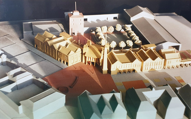
Photograph, Ballarat School of MInes Architectual Model
Colour photograph of the Ballarat School of MInes Architectual Modelballarat school of mines architectual model, ballarat school of mines, campus plan -
 Federation University Historical Collection
Magazine, Ballarat School of Mines Students' Magazine, 1962, 1962
Black yellow and grey soft covered school magazine. ballarat school of mines, ian weit, gordon johnson, kerry penna, kevin oscar rogers, robert coutts, graeme waller, anita bitans, noel kelly, john davis, tony brauer, sue davies, stanley white, harry arblaster, richard d. richards medal, dick richards medals, john boermans, harry goldsmith retirement, j.r. pound, microliths, stone tools, ross gray, harold yates retirement, eric mcgrath award, students' representive council, student union, kevin o. rogers, ballarat asian society, m. moissinac, b.c. gan, b. tanthiem, l.k. oh, b. eng, austral-asian relationships, colombo plan, treatise on rugby, beat generation, university in ballarat, civil defence, ross sea shore party, hester darby retirement -
 Federation University Historical Collection
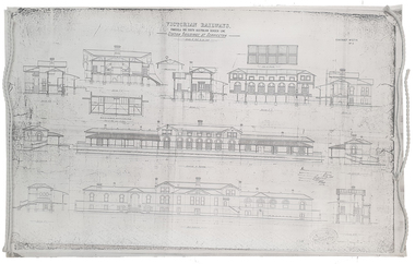
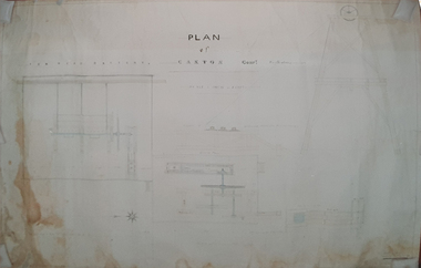
Plan, Copy of a Plan of Serviceton Railway Station Building, 1888
The Serviceton Railway Station was completed in 1889 , with the Colony of Victoria and the Colony of South Australia sharing the cost. Ut was at Serviceton the the Victorian rail line and the Adelaide-Wolseley railway line of South Australia joined. The Railway Station included customs offices which were no longer necessary after the Federation of Australian States in 1901. ( https://en.wikipedia.org/wiki/Serviceton,_Victoria, accessed 30 August 2021)Copy of plan for the Serviceton Railway Linerailway, servicetone railway station, plan, serviceton -
Federation University Historical Collection
Document, Allum Lovell, Former Ballarat Brewery Conservation Analsysis, c1990
Carlton and United Breweries purchased the Ballarat Brewering Company Limited site in 1958, including its chain of 114 hotels. In the mid 1980s CUB transferred the production of Blalarat Bertie to the Abbotsford plants and started producing Guimes under license in the Ballarat plant. On 30 June 1989 CUB closed the Ballarat site.Report conducted by Allum Lovell for the Ballarat School of Mines. former ballarat brewery, conservation management plan, james coglan, william kenna, tulluch and mclaren, phoenix brewery, chimney, brew tower, cooling tower, carlton and united breweries, brewery building -
Federation University Historical Collection
Booklet, Michael Taffe, Beaufort House Ballarat Conservation Plan, 2004
Michael Taffe undertook this Conservation Pan while completing an Bachelor of Arts (Honours) at the University of Melbourne in 2004.Forty five page conservation management plan for Beaufort House. Includes: * Dowling Forest Paris Plan * Plan of Drainagebeaufort house, student residences, student accomodation, certificate of title, dowling forest, henry cuthbert, archibald mckay, max mckay, beaufort street, cardigan street, stables, charles davernport cuthbert -
 Federation University Historical Collection
Plan, W. Watson, Plan of Caxton Company Smythesdale, 07/02/1886
Framed large ink drawing of a ten head battery, winding and pumping machines, gearhouse and framing. caxton company, smythesdale, w. watson, architectural plan -
 Federation University Historical Collection
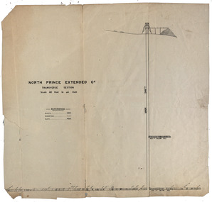
Plan, North Prince Extended Co
Transverse section of the North Prince Extended Co,north prince extended, mining company, gold -
 Federation University Historical Collection
Plan, Ballarat School of Mines New Workshops, 17/11/1944
Hand drawn planballarat school of mines, new workshops, albert street -
 Federation University Historical Collection
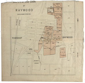
Plan, Raywood Gold Mining Lease Blocks, c1986
Raywood is in the State of Victoria.Gold mining lease blocks at Raywood. Thought to be from The Gold-Fields of Victoria Reports of The Mining Registrars for the Quarter Ended 30th June 1886raywood, raywood botanical gardens, pound, raywood state school, buxton, new buxton, new perserverance, pioneer, new nil, south pioneer and may reef, london -
Federation University Historical Collection
Plan, Refurbishment Plans for Mount Helen Campus F Building, c2004
f building, plan, refurbishment, buildings -
 Federation University Historical Collection
Document, Dianne Campbell, Ballarat History Research Folders, c2000-2021
Two folders of research notes on Ballarat Lawyers, including newspaper clippings, website information, etc .1) newspaper clippings, Plan of Township and Extension of Ballarat County of Grenville 1855, Plan of the Township of Ballarat, Ballarat District from Victoria and It's Metropolis, American Republicanism and the Disturbances on the Victorian Goldfields, Sovereign Remedies, History of the Mechanics' Institute (Spielvogel), Irish in Australia. .2) Curiosity Shop, Mary Amelia Cuthbert; letter from MR to WLR 1860), Ulysses Bound (Richardson)`, Henry Handel Richrdson, Gas in Ballarat, George Binsteadballarat lawyers, di campbell goldfields lawyers collection, ballarat, gas, walter richardson, ballarat high school centenary, courier articles by anne beggs sunter, courier articles by dorothy wickham, courier articles by peter butters -
Federation University Historical Collection
Plan, Ballarat Girls' Secondary School, Barkly Street, 1957
ballarat girls secondary school, ballarat east, barkly street -
 Federation University Historical Collection
Plan, University of Ballarat Union Building Upgrade Preliminary Concept Plans, November 1998, 11/1998
University of Ballarat is a predecessor of Federation UniversitySpiral bound Plans for University of Ballarat Union Building Upgrade Nov 1998union building upgrade, university of ballarat, preliminary concept plans, union building, albert coates building, mount helen campus, building, u building -
 Federation University Historical Collection
Plan, University of Ballarat Campus Layout and Building Plans September 1995
University of Ballarat is a predecessor of Federation UniversityA3 pages with plans of University of Ballarat Campus layout and building plans With Compliments Slip from Prof. P. Candybuilding plans, university of ballarat, campus layout, prof. p candy, with compliments -
 Federation University Historical Collection
Plan, University of Ballarat Union Building Upgrade Design Development Report July 1999
University of Ballarat is a predecessor of Federation University A3 sized booklet with spiral binding containing plans and report for the Union Building Upgradeuniversity of ballarat, union building upgrade, design developement report, vincent chrisp architects -
 Federation University Historical Collection
Plan, The Ararat Chinese Heritage Society Present Gum San Chinese Heritage Museum Concept Design and Development
Dick de Fegley who was on the University of Ballarat Council was highly involved with the development of Gum San Museum. University of Ballarat is a predecessor of Federation University.A3 document containing plans and information pertaining to the development of Gum San Chinese Heritage Museumdick de fegely, gum san chinese heritage museum, challis design, ararat chinese heritage society