Showing 513 items
matching new bendigo mine
-
 Bendigo Historical Society Inc.
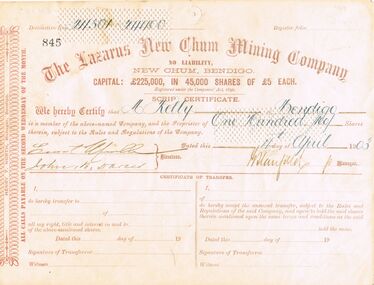
Document - LAZARUS NEW CHUM MINING COMPAN Y SHARE CERTIFICATE
... Inc. History House 11 Mackenzie Street Bendigo goldfields MINE ...Share Certificate from The Lazarus New Chum Mining Company for 100 shares issued to Mr. M. Kelly and dated 4th April 1903.mine, gold, lazarus new chum, gold mines, gold mining, new chum line lazarus company, share certificates -
 Bendigo Historical Society Inc.
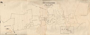
Map - DEVONSHIRE GROUP OF MINES BENDIGO
Map showing the mining leases that include the Devonshire group of mines - leases shown from north to south are: Catherine Reef United , William United, Ellenborough, Sadowa, St. Mungo, Lady Barkly, South St. Mungo, Phoenix, United Devonshire, Duchess of Edinburgh, New St. Mungo, South Devonshire, Extended South Devonshire, New Victoria Catherine, Pearl, Hercules and Energetic.Issued by M. P. Kelly, Sharebroker, Bendigomap, bendigo, goldfields, catherine reef united , williamd united, ellenborough, sadowa, st. mungo, lady barkly, south st. mungo, phoenix, united devonshire, duchess of edinburgh, new st. mungo, south devonshire, extended south devonshire, new victoria catherine, pearl, hercules and energetic. mining, gold mines -
 Bendigo Historical Society Inc.
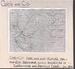
Photograph - COBB & CO,., MAP OF COACH RUN TO BENDIGO
black and white image ( copy ) on board : image shows map of roads to all gold mines in Victoria., showing Cobb & Co., routes. Written on board: Cobb and Co., Cobb & Co's first and most historic run was from Melbourne to the goldfields of Castlemaine and Bendigo Creek, Jan 1854./// image shows -'Map of the roads to all gold mines in Victoria., showing the Cross roads from one mine to another with indications of various stations divided into squares of ten miles to easily calculate the distance of any new mines when discovered ///There is a list of towns with their distance from Melbourne and to & from distances for other destinations Cobb & Co., routesbusiness, transport, cobb & co., cobb & co., bendigo, transport -
 Bendigo Historical Society Inc.
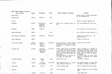
Document - LONG GULLY HISTORY GROUP COLLECTION: NEW CHUM REEF MINE STATS
Copy of a page titled New Chum Reef (Continued). Listed is the name of Mine, Depth, Production, Dates, Plant, Machinery, Comments and Position. Mines listed are:- Little Chum, Young Chum, Craven, Garibaldi, Ellesmere, South Old Chum, New Chum Consolidated, North Ellesmere, New Chum United, Abraham Lincoln Battery, Lansell's 222, Fortuna Battery, Lansell's Fortuna, Lazarus, Lazarus, West End and Pioneer,bendigo, history, long gully history group, the long gully history group - new chum reef mine stats, little chum, young chum, craven, garibaldi, ellesmere, south old chum, new chum consolidated, north ellesmere, new chum united, mt alvernia hospital, abraham lincoln battery, lansell's 222, fortuna battery, fortuna, private tunnel, lansell's fortuna, lunt, lazarus, chum hill, lazarus, west end, army survey unit, pioneer -
 Bendigo Historical Society Inc.
Document - LONG GULLY HISTORY GROUP COLLECTION: VICTORIA HILL
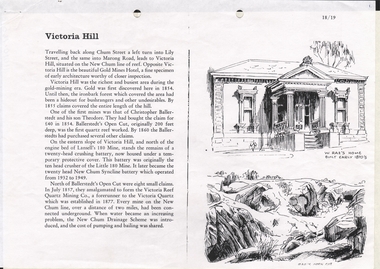
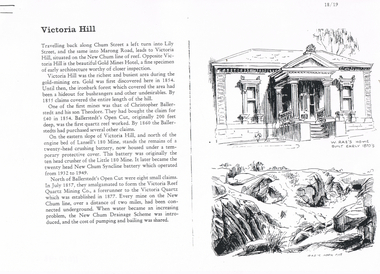
3 Pages titled Victoria Hill. On one side is a sketch of W Rae's Home built in the early 1870's and Rae's Open Cut. Mentioned is a short history of Victoria Hill and the mine of Christopher Ballerstadt and his son Theodore. The remains of a 20 head crushing battery, which was originally the ten head crusher of the Little 180 Mine remains. It later became the twenty head New Chum Syncline Battery. Water became a problem and the New Chum Drainage Scheme was introduced and the cost of pumping and bailing was shared between the mines.bendigo, history, long gully history group, the long gully history group - victoria hill, gold mines hotel, christopher ballerstedt, theodore ballerstadt, ballerstadt's open cut, lansell's 180 mine, little 180 mine, new chum syncline battery, victoria reef quartz mining co, victoria quartz, new chum drainage system, w rae's home, rae's open cut -
 Bendigo Historical Society Inc.
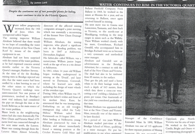
Newspaper - LONG GULLY HISTORY GROUP COLLECTION: WATER CONTINUES TO RISE IN THE VICTORIA QUARTZ
Photo of a newspaper article titled Water Continues to Rise in the Victoria Quartz by James Lerk. Article mentions William Abraham who was the mining inspector, who played a significant role in the flooding problem. Water levels had risen dramatically. Water flowed from one mine to another where they were connected. Article also mentions Abraham's birthplace, his early start to work at the age of 10 as a tin dresser at Ashburton, Devonshire, England and his working life after he migrated to Australia at the age of 19. His career in Australia is also mentioned. The article is accompanied by a photo of Abraham with his horse.bendigo, history, long gully history group, the long gully history group - water continues to rise in the victoria quartz, james lerk, william abraham, new chum reef, matthew stevens, south bellevue, new chum and victoria mine, lazarus mine, new chum drainage association, william abraham snr, mary kane, lady miltoa (ship), cricket reserve gold mine, ballarat freehold company, wallaby mine, richard grenfell, bendigo advertiser, bendigo school of mines, confidence extended mine -
 Bendigo Historical Society Inc.
Document - LONG GULLY HISTORY GROUP COLLECTION: VICTORIA HILL
Three pages numbered 18/19, 20/21 and 22/23 titled Victoria Hill. First page has some information on Victoria Hill, a sketch of W Rae's Home and Rae's Open cut. The second page has a map of the Victoria Hill Area showing streets and the New Chum Anticline, a sketch of Ballerstedt's Open Cut and a Key to Victoria Hill Area Map. The third page mentions the Victoria Quartz mine, Tributors and quartz roasting. It also has sketch of a 20 Head Crushing Battery, Victoria Hill.bendigo, history, long gully history group, the long gully history group - victoria hill, gold mines hotel, christopher ballerstedt, theodore ballerstedt, ballerstedt's open cut, lansell's 180 mine, little 180 mine, new chum syncline battery, victoria reef quartz mining co, victoria quartz, new chum drainage scheme, a roberts and sons, tributors, william rae's bon accord mine and open cut, william rae, adventure and advance open cuts, central nell gwynne, heinz butcher shop -
 Bendigo Historical Society Inc.
Photograph - LAZARUS ENGINE, HORSE AND BATTERY, c.1890
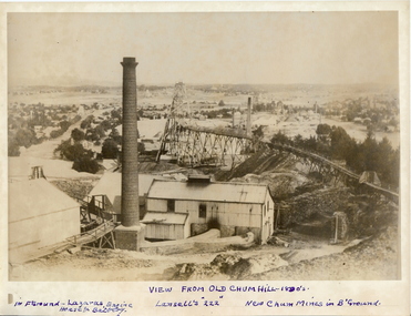
Black and white photograph. Brick chimney, C.I building, poppet head with tramway, square chimney in centre. Chimneys and poppet heads in distance. Inscriptions: Hand written in ink in bottom margin 'View from Old Chum Hill - 1890's. In foreground 'Lazarus Engine, Horse & Battery', ' Lansell's '222' '. 'New Chum Mines in background'. History of object: James Lerk 18.2.2000 'Correctly labelled on front of photo'.place, mining site -
 Bendigo Historical Society Inc.
Photograph - MINING AREA VIEW FROM NEW CHUM HILL, 1875
Black and white photograph. View overlooking mining area from New Chum Hill in the early 1870's showing four poppet legs and at least 9 chimneys (small chimneys and poppets at L distance). Golden Square Methodist Church C distance. Inscriptions: typed on front 'Looking South from New Chum Hill in early 1970's. The rich :Lazarus New Chum: in foreground. Other rich New Chum Mines in background'N J Caireplace, mining site, see also 2001.003.01 -
 Bendigo Historical Society Inc.
Photograph - MINING AREA VIEW FROM NEW CHUM HILL, 1875
Black and white photograph. View overlooking mining area from New Chum Hill in the early 1870's showing four poppet legs and at least nine chimneys (small chimneys and poppets at L distance). Golden Square Methodist Church, Laurel Street C distance. Inscriptions on back: 'MNG 21' and round 'Historical society of Victoria, Bendigo Branch' stamp. Typed on front: 'Looking South from New Chum Hill in early 1870's. The rich 'Lazarus New Chum' in foreground. Other rich New Chum Mines in background'. History of object: Previous Acc. No. 'MNG 21', James Lerk, 26.11.1999, N.J. Caire, photograph 1875'.N.J. Caireplace, mining site, see also 2001.004.01 -
 Bendigo Historical Society Inc.
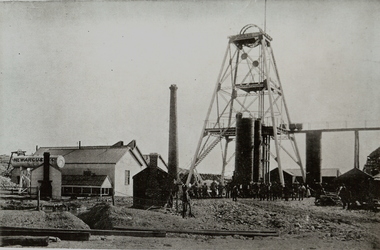
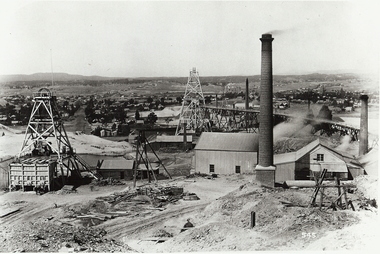
Photograph - NEW ARGUS MINE
... MINING Surface equipment new argus Bendigo mines and mining mines ...Black and white photograph of mine workings. Poppet head, chimney and associated buildings. Approximately 20 people gathered in line at base of poppet head. Inscriptions : on front 'New Argus' on elevated tank in image and in pencil in bottom margin. On Back - '23', 'New Argus', 'A Richardson, 290 Harrison St, Bendigo.mining, surface equipment, new argus, bendigo, mines and mining, mines, mining, poppet head, mining sheds -
 Bendigo Historical Society Inc.
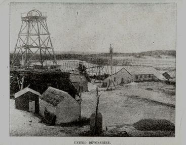
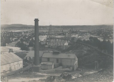
Photograph - UNITED DEVONSHIRE
Black and white photograph of an image. Poppet head, overhead tramway, mine buildings, dam. Inscriptions: on front at bottom - printed 'United Devonshire'. Inscriptions: on back, type written. 'The 'United Devonshire' - New Chum Line of Reef'. Situated in the Devonshire Valley immediately south of Victoria St, Eaglehawk. Was the leading mine in the field in the years 1883-4 and 1885 during which time it produced 65,898 oz of gold and paid $(?)399,800 in dividends. This mine was then situated on what in January, 1902, became the West Shaft. The Company was then amalgamated with the 'Princess Alexandra' (approx 100 yds further east) which then became the Main Shaft of the 'United Devonshire'. All typed on paper and glued to back of image. Handwritten in ball point pen 'A Richardson, 29 Harrison St, Bendigo'.mining, surface equipment, united devonshire, bendigo, mines and mining, poppet head, eaglehawk, devonshire valley, mining sheds -
 Bendigo Historical Society Inc.
Photograph - UNITED DEVONSHIRE
Black and white photograph of an image. Poppet head, overhead tramway, mine buildings, dam. Inscriptions: on front at bottom - printed 'United Devonshire'. Inscriptions: on back, type written. 'The 'United Devonshire' - New Chum Line of Reef'. Situated in the Devonshire Valley immediately south of Victoria St, Eaglehawk. Was the leading mine in the field in the years 1883-4 and 1885 during which time it produced 65,898 oz of gold and paid $(?)399,800 in dividends. This mine was then situated on what in January, 1902, became the West Shaft. The Company was then amalgamated with the 'Princess Alexandra' (approx 100 yds further east) which then became the Main Shaft of the 'United Devonshire'. All typed on paper and glued to back of image. Handwritten in ball point pen 'A Richardson, 29 Harrison St, Bendigo'.mining, surface equipment, united devonshire, bendigo, mines and mining, mines, poppet head, mining sheds, devonshire valley, eaglehawk -
 Bendigo Historical Society Inc.
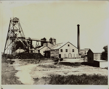
Photograph - NEW RED, WHITE AND BLUE MINE
Black and white photograph. Poppet head, winder house, chimney, overhead tramway, stack of wood, one male figure pushing one truck on overhead tramway. Mine office at front right. Inscriptions: On front - '26' at TL. On back - 'New Red, White and Blue Consolidated, Main Shaft (Big Blue). Rec'd photo 21/4/67.'mine, gold, big blue ( r.w.b.consolidated), bendigo, mines and mining, mines, mining, poppet head, mining equipment -
 Bendigo Historical Society Inc.
Photograph - GOLD MINE BENDIGO, LAZARUS' CLAIM, C 1860's
Black and white photo: dam in foreground, building and whims on hill in background and tall chimney on rh side. Isolated ( residential ) building on hill at the rear. On front ' Batchelder/Sandhurst' ( not clear ) On back ' Gold mines, Bendigo - probably looking nw along New Chum Hill, with Lazarus' claim in foreground. Phoenix - later Old Chum Mine background'Batchelderorganization, business, lazarus' mine -
 Bendigo Historical Society Inc.
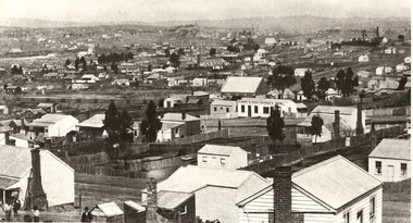
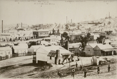
Photograph - NEW CHUM GULLY C 1875, C 1875
Back and white photograph: panorama showing timber and brick residences, hotel, church ? Mines with poppet heads and chimneys in background. An image on building at centre ' Cleary's Honeysuckle Hotel' Ken Arnold captions this image ' New Chum Gully from Specimen Hill C 1875, photographer Caire 'Caireplace, landscape view, new chum gully, bendigo, cityscape, sandhurst, panorama, mining town -
 Bendigo Historical Society Inc.
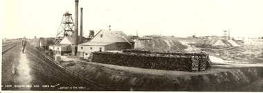
Photograph - NEW CHUM RAILWAY GOLD MINE
... Gold new chum hill 180 mine Bendigo mines and mining railway ...Black and white photograph. Mine site with poppet head and mine buildings. Stacks of wood in foreground. Two chimneys. Poppet heads and chimneys in background. Inscriptions: in image - printed at BL '..w Chum Railway Gold Mine * 4226 feet, deepest in the world'. 'New Chum Railway 4,318 feet deep. One of the deepest in the world', 'A Richardson, 29 Harrison St, Bendigo'. All written on back in ballpoint pen.mine, gold, new chum hill, 180 mine, bendigo, mines and mining, railway line, gold mine, mines, place, gold mines -
 Bendigo Historical Society Inc.
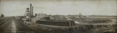
Photograph - NEW CHUM RAILWAY MINE, c.1905
... Gold new chum railway Bendigo New Chum gold mine mines ...Panoramic photograph from the Melbourne to Bendigo railway line of the New Chum Railway Mine. Railway red white and blue, north red white and blue, new red white and blue consolidated. No. 3 red, white and blue, eureka extended and south bellevue? Mines. Inscriptions: in image - 'New Chum Railway Goldmine 4226 feet - deepest in the world'. 'Copyright R Scott Melb'. On back - '1 neg and 4 prints' (in ballpoint pen). 'MNG 27', 'A Richardson, 29 Harrison St, Bendigo' (ballpoint), A Richar, 29 Harr, Ben' (dark blue ink), 'Royal Historical Society of Victoria, Bendigo Branch' (stamp seal)R Scott Melbournemine, gold, new chum railway, bendigo, new chum gold mine, mines and mining, place, bendigo mines, railway line, gold mine, place, mining -
 Bendigo Historical Society Inc.
Photograph - BENDIGO: LANDSCAPE VIEW - NEW CHUM MINE, 1875
... BENDIGO: LANDSCAPE VIEW - NEW CHUM MINE... BENDIGO: LANDSCAPE VIEW - NEW CHUM MINE ...black and white photo ( copy ) view of portion of Bendigo showing weatherboard cottages, large brick houses, mine chimneys, poppet legs, adults in foreground. On image handwritten on top ' New Chum United, Fortuna, B. Lazarus home, Lazarus New Chum, Old Chum. On back in pen ' New Chum Mines, Lansell's Fortuna in background, J.B. Lazarus' home in middle distance.' A. Richardson, 29 Harrison St.,N.J. Caireplace, landscape view, bendigo -
 Bendigo Historical Society Inc.
Photograph - NEW CHUM MINE WORKINGS
... Bendigo Vic. Mine workings - near New Chum Mine.... Back ' mining gold Bendigo Vic. Mine workings - near New Chum ...black and white photo ; ( copy ) view from Chum Hill, poppet heads, buildings and chimneys in middle foreground, residential area in background. On front 545. Back ' mining gold Bendigo Vic. Mine workings - near New Chum Mine. ' not to be reproduced without permission from the National Library. James Lerk 18.2.2000 ; ' view from Chum Hill, left Lazarus Mine, right Lansell's 222 looking south 'organization, business, new chum mine -
 Bendigo Historical Society Inc.
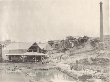
Photograph - NEW MOON MINE
photocopy of photograph of New Moon Company mine showing poppet head, buildings and chimney. ( NO LIABILITY EAGLEHAWK).organization, business, new moon mine -
 Bendigo Historical Society Inc.
Photograph - NEW MOON MINE
copy of sepia photograph: elevated view of New Moon mine. Elevated tramway on left, crushing battery on right. Log storage in foreground. Appears to be photocopy of photograph ? On back ' view from poppetheads of New Moon Mine looking south east and showing tramway and crushing battery.lorganization, business, new moon mine -
 Bendigo Historical Society Inc.
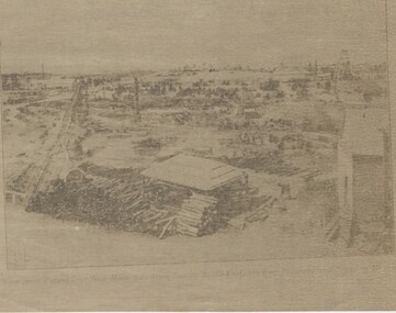
Photograph - NEW MOON MINE, 1906 ?
black and white photo mounted on green board : black and white photo of electric generating plant and compressor at the New Moon Mine Eaglehawk, installed 1906 ? Machinery in corrugated iron building with wooden floor. James Lerk 26.11.1999 ' electric generating plant and compressorA.G. Levy , photographer, Eaglehawk.organization, business, new moon mine -
 Bendigo Historical Society Inc.
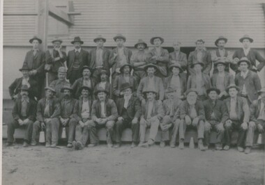
Photograph - SOUTH NEW MOON MINE - WORKERS, 1906 ?
black and white photo : mine site with workers. South New Moon Mine - Sam Bartlett centre front, mine manager ( James Lerk, 26th. Nov. 1999 ) 3 rows of males, dressed in jackets, hats. Standing in front of corrugated iron buildingperson, group, south new moon mine -
 Bendigo Historical Society Inc.
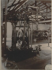
Photograph - NEW MOON MINE WINDING ENGINE
... ' A. Richardson, 29 Harrison St., Bendigo. . Photograph NEW MOON MINE ...black and white photo : interior of shed showing winding gear. On front: ' View of winding plant at the Mine ( printed ) New Moon ( handwritten & Signature AR ) On back in biro ' winding engine - New Moon Mine 1906. Makers Harkness & Co., Bendigo. ' Written in biro bottom right ' A. Richardson, 29 Harrison St., Bendigo. .organization, business, new moon mine -
 Bendigo Historical Society Inc.
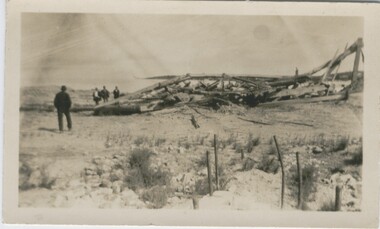
Photograph - IRONBARK MINE, NEW CHUM REEF, BENDIGO, 1930 ?
... IRONBARK MINE, NEW CHUM REEF, BENDIGO... and sand heap behind it. Photograph IRONBARK MINE, NEW CHUM REEF ...black and white photo: collapsed wooden poppet head of the Ironbark Mine, four men on the left hand side., with engine holding down bolts in the right foreground. 'Old Ironbark, New Chum Reef ?' 26.11.1999 Previous mng 39 In pen - Ironbark legs looking from the tram track and sand heap behind it.organization, business, ironbark mine -
 Bendigo Historical Society Inc.
Photograph - LANSELL'S 222 MINE
black and white photo: Lansell's 222 mine. Various poppet heads in distance, chimney, poppet head and mine buildings in foreground. On back of photo: 'Lazarus Enginehouse; 3,650 ft. ' Lansell's 222. Taken from Old Chum Hill. New Chum Line. ' View from Chum looking at the 222 mine - Sheepshead Line of Reef on left. ( J. Lerk 26.11 1999 ) Bottom right hand Corner A Richardson 29 Harrison Street BendigoVincent Kelly Bendigo - embossed bottom right corner.organization, business, lansell's 222 mine -
 Bendigo Historical Society Inc.
Photograph - VICTORIA HILL, approx 1875
Black and white photograph showing 2 poppet heads, 3 chimneys, dam, 2 wood stacks, associated sheds, mine manager's house, few trees. Copy of photograph ' New Chum Reef - looking north N.J. Caire photo 1875 - copy J. Lerk, 11.2.2000'N.J. Caire ?place, landscape view, new chum reef -
 Bendigo Historical Society Inc.
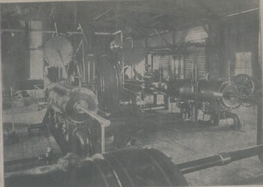
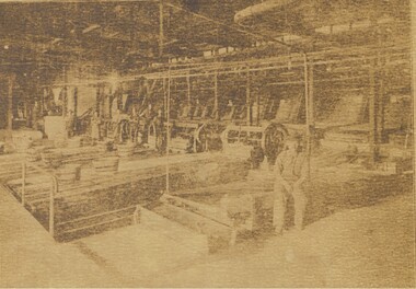
Photograph - NEW MOON/STH: NEW MOON MINE
Sepia copy ( photocopy ) machinery, wheels, driving belts, iron hooped wooden barrels on bench. 6 adult males in background, 1 adult male in foreground. 'New Moon or Sth. New Moon' J. Lerk. On back 'cannot identify' stamp mark 'Bendigo Branch in circle. On the front ' View showing head of stamping machine 'organization, business, new moon mine -
 Bendigo Historical Society Inc.
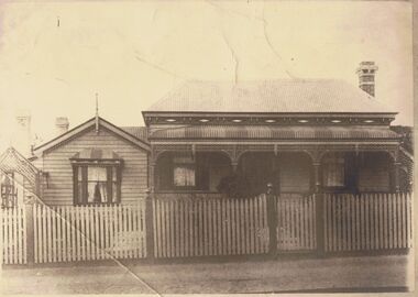
Photograph - VICTORIAN HOUSE: SAMUEL BARTLETT'S
Black and white photo of weatherboard house with picket fence , corrugated iron roof, bull nose verandah with painted striped roof. At left single fronted addition with gable roof , bow window, finial, extensions at left side at back. Lattice arch at left, 3 chimneys visible. Lattice enclosure at right. J. Lerk ( 5.11.1999 ) 'Samuel Bartlett's house, Job's Gully, Eaglehawk' On back of photo in pencil ' home of Sam Bartlett, Manager of South New Moon Mine 'rephotographed by H.J.G. Biggs ( J. Lerk 25.8.2000 )buildings, residential, samuel bartlett