Showing 97 items
matching north east region
-
 Bendigo Historical Society Inc.
Album - Merle Bush Trefoil Guild: Photographs
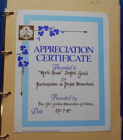
The Merle Bush Trefoil Guild was registered in Bendigo on 18/06/1981.The decision to disband the Merle Bush Trefoil Guild was made at a General Meeting on 17/02/2016. The group agreed to continue as the Merle Bush Friendship Group. The Australian Trefoil Guilds connect women who are either actively involved in Girl Guiding or have a history with Girl Guiding. The purpose of a Trefoil Guild is to keep alive the spirit of the Promise and Law, carry this spirit into the community and to give support Guiding.Blue vinyl covered four ring binder containing photographs of activities of the Merle Bush Trefoil Guild. The photographs are mounted (glued) on to buff coloured card from manilla folders cut in half. 61 pp with hand written numbers in top RH corner. Pages 25 and 26 Missing. The first page has an "Appreciation Certificate Awarded to the Merle Bush Trefoil Guild for Participation in Project Branchout. Presented by The Girl Guides association of Victoria. Date 25-7-87. The pages have handwritten annotations of names of people in the photographs. Includes Region Conference East Loddon 25/08/89, 7th National Gathering Stawell Tops 1985, 8th National gathering Monash university 1988 Tour of Government House Day 16th December 1989 Brittania Park labour Day Weekend 1990 A.G.M. 5th May 1990 Region Reunion Day Cohuna 19th August 1990 RR Day North Central Region 10th A.G.M. 4th May 1991 Reaffirmation of Promise 2/7/91 Gwen Derby and Fay Osborn The Chalet, Brittania Park, March Long weekend 1992 24 Hour Gathering Bendigo 15/16 October 1997 Benalla Rose Gardens 16 May 2001 Social BBQ Christmas 2001 Melbourne Cup day 1999 24 Hour Gathering Oct 1999 24 Hour Gathering Stawell 2001 24 Hour Gathering Phillip Island 2003 25th Anniversary 2006 Long Service Awards 15 Oct 2006 100 years of Guiding Christmas 2011girl guides, guiding, merle bush, trefoil guild -
 National Vietnam Veterans Museum (NVVM)
Poster - Poster, Information Board, 5 RAR 1966 - 1967 (1st Tour)
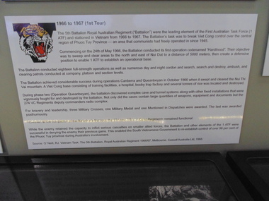
An Poster, Information Board of 5 RAR 1966 to 1967 (tst Tour). The 5th Battalion Royal Australian Regiment ("Battalion") were the leading element of the First Australian Task Force (1 ATF) and stationed in Vietnam from 1966 to 1967. The Battalion's task was to break Viet Cong control over the central region of Phuoc Tuy Province - an area that communists had freely operated in since 1945. Commencing of the 24th May 1966, the Battalion conducted its first operation codenamed "Hardihood". Their objective was to sweep and clear areas to the north and east of Nui Dat to a distance of 5000 meters, then create a defensive position to enable 1 ATF to establish an operation base. The Battalion conducted eighteen full-lenght operations as well as numerous day and night cordon and search, search and destroy, ambush and clearing patrols conducted at company, platoon and section levels. the Battalion achieved considerable success during Operations Canberra and Queanbeyan in October 1966 when it swept and cleared the Nui Thi Vai mountain. A Viet Cong base consisting of training facilities, a hospital, booby trap factory and several tonnes of rice was located and destroyed. during phase two (Operation Queanbeyan) the battalion discovered complex cave and tunnel systems along with other fixed installations that were vigorously fought for and destroyed by the battalion. Not only di the caves contain large quantities of weapons, equipment and documents but the 274 VC Regiments deputy commanders radio complex. For bravery and leadership, three Military Crosses, one Military Medal and one Mentioned in Dispatches were awarded. The last was awarded posthumously. However, at the completion of the battalion's first tour, the 274 and 275 Viet Cong Regiments remained functional. While the enemy retained the capacity to inflict serious casualities on smaller allied forces, the Battalion and other elements of the 1 AFt were successful in denying the enemy their previous gains. This enabled the South Vietnamese Government to re-establish control of over 96 per cent of the Phuoc Tuy Province during Australia's involvement. Source O'Neill, RJ Vietnam Task, the 5th Battalion, Royal Australian Regiment 1966/67, Melbourne. Cassell Australia Ltd, 19685 rar, 1st tour 1966 - 1967, operation hardihood, 1st atf base, poster, information board, nui dat, nui thai vai mountains, operation canberra, operation queanbeyan, viet cong, 274 vc regiments -
 National Vietnam Veterans Museum (NVVM)
Poster - Poster, Information Board, 5 RAR 1969 - 1970 (1st Tour)
An Poster, Information Board of The 5th Battalion Royal Australian Regiment ("Battalion") were the leading element of the First Australian Task Force (1 ATF) and stationed in vietnam from 1966 - 1967. The Battalion's task was to break Viet Cont control over the central region of Phuoc Tuy Province - an area that communists had freely operated in since 1945. Commencing of the 24th May 1966, the Battalion conducted its first operation codenamed "Hardihood". Their objective was to sweep and clear areas of the north and east of Nui Dat to a distance of 5000 meters, then create a defensive position to enable 1 ATF to establish an operational base.5 rar, 1 atf, viet cong, phuoc tuy province, nui dat, nui thai vai mountains, 274 vc regiments, 275 vc regiments, military awards, rj o'neill, operation canberra, operation queanbeyan, operation hardihood, poster, information board -
 Chiltern Athenaeum Trust
Domestic object - Spoon
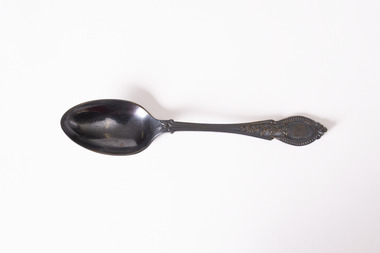
This teaspoon is believed to belong to the household of Chiltern writer and historian, W.C. Busse. The teaspoon displays a level of tarnish indicating it may be comprised of silver or silver plate. It has no evident hallmark to determine its maker or date of manufacture, but may pre-date World War Two as mass production methods and the growing popularity of stainless steel in cutlery and other tablewares saw a reduced reliance on silver in such goods after this period. Wilfred Clarence Busse was born in Chiltern in 1898. He went to school at Wesley College in Melbourne, studied law at the University of Melbourne and became a barrister. Additionally, after spending time on a Victorian station in his early twenties, he wrote two historical novels about bush life. His first novel was 'The Blue Beyond: a Romance of the Early Days in South Eastern Australia', written in 1928 and published in 1930. Busse's second novel was titled 'The Golden Plague: A Romance of the Early Fifties'. The judges of the Henry Lawson Society's T.E. Rofe competition to advance Australian literature unanimously awarded it the Gold Medal in 1931 for the best historical novel of 1930. Newspaper articles about the award mention the writer's meticulous documentary and oral history research regarding life on the Gold Fields in the 1850s. It became a best-seller. Busse also wrote a series of articles about local history for "The Federal Standard" newspaper in Chiltern. He was a member of the Chiltern Athenaeum. He died in 1960. This spoon is significant for the detail it conveys of ordinary domestic life in the household of a significant Victorian writer with special reference to Chiltern and the surrounding region. Teaspoon with decorative pattern on handle and tarnished patina. w.c. busse, chiltern, wilfred clarence busse, chiltern athenaeum, gold fields, gold rush, gold mining, mining history, historical fiction, cutlery, tableware, silverware, spoons, henry lawson society, t.e. rofe, t.e. rofe gold medal, federal standard newspaper, 1930s, 1850s, barrister, north-east victoria, indigo shire -
 Chiltern Athenaeum Trust
Domestic object - Fork
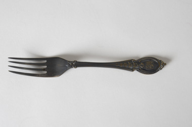
This fork is believed to belong to the household of Chiltern writer and historian, W.C. Busse. It displays a level of tarnish indicating it may be comprised of silver or silver plate. It has no evident hallmark to determine its maker or date of manufacture, but may pre-date World War Two as mass production methods and the growing popularity of stainless steel in cutlery and other tablewares saw a reduced reliance on silver in such goods after this period. The handle of the fork appears to display the initials 'WB', potentially indicating it was made to order. Wilfred Clarence Busse was born in Chiltern in 1898. He went to school at Wesley College in Melbourne, studied law at the University of Melbourne and became a barrister. Additionally, after spending time on a Victorian station in his early twenties, he wrote two historical novels about bush life. His first novel was 'The Blue Beyond: a Romance of the Early Days in South Eastern Australia', written in 1928 and published in 1930. Busse's second novel was titled 'The Golden Plague: A Romance of the Early Fifties'. The judges of the Henry Lawson Society's T.E. Rofe competition to advance Australian literature unanimously awarded it the Gold Medal in 1931 for the best historical novel of 1930. Newspaper articles about the award mention the writer's meticulous documentary and oral history research regarding life on the Gold Fields in the 1850s. It became a best-seller. Busse also wrote a series of articles about local history for "The Federal Standard" newspaper in Chiltern. He was a member of the Chiltern Athenaeum. He died in 1960.This fork is significant for the detail it conveys of ordinary domestic life in the household of a significant Victorian writer with special reference to Chiltern and the surrounding region.Fork with decorative pattern on handle and tarnished patina, design may include owner's or maker's initials. WB w.c. busse, chiltern, chiltern athenaeum, gold fields, indigo shire, gold mining, gold rush, henry lawson society, fork, silverware, cutlery, tableware, 1930s, 1850s, wilfred clarence busse, historical fiction, t.e. rofe, t.e. rofe gold medal, north-east victoria, federal standard, golden plague, blue beyond -
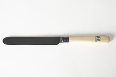 Chiltern Athenaeum Trust
Domestic object - Knife, T. Turner & Co, 1907
This knife is believed to belong to the household of Chiltern writer and historian, W.C. Busse. It displays a level of tarnish indicating it may be comprised of silver or silver plate. The blade contains the mark 'EP' which may indicate silverplate over steel. The blade also contains the maker's mark 'Wingfield', which was the trademark of T. Turner & Co but could also refer to the company Wingfield Rowbotham. Both factories are located in Sheffield, United Kingdom. The trademark is ascribed to goods produced in approximately 1907. The handle of the knife displays the initials 'WB', potentially indicating it was made to order. Wilfred Clarence Busse was born in Chiltern in 1898. He went to school at Wesley College in Melbourne, studied law at the University of Melbourne and became a barrister. Additionally, after spending time on a Victorian station in his early twenties, he wrote two historical novels about bush life. His first novel was 'The Blue Beyond: a Romance of the Early Days in South Eastern Australia', written in 1928 and published in 1930. Busse's second novel was titled 'The Golden Plague: A Romance of the Early Fifties'. The judges of the Henry Lawson Society's T.E. Rofe competition to advance Australian literature unanimously awarded it the Gold Medal in 1931 for the best historical novel of 1930. Newspaper articles about the award mention the writer's meticulous documentary and oral history research regarding life on the Gold Fields in the 1850s. It became a best-seller. Busse also wrote a series of articles about local history for "The Federal Standard" newspaper in Chiltern. He was a member of the Chiltern Athenaeum. He died in 1960.This knife is significant for the detail it conveys of ordinary domestic life in the household of a significant Victorian writer with special reference to Chiltern and the surrounding region. Knife with tarnished patina and cream-coloured handle with owner's initials engraved or stamped.WBw.c. busse, chiltern, gold fields, gold mining, gold rush, north-east victoria, indigo shire, wingfield, t.turner & co, wingfield rowbotham, silver, silverplate, knife, cutlery, silverware, tableware, barrister, wesley college, melbourne, historical fiction, golden plague, blue beyond, henry lawson society, t.e. rofe, 1930s, 1850s -
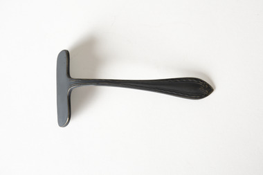 Chiltern Athenaeum Trust
Domestic object - Child's food pusher, J. Biggin & Co, Unknown
This children's eating utensil is believed to belong to the household of Chiltern writer and historian, W.C. Busse. The level of tarnish and the mark 'EPNS' may indicate it is electroplated. The blade also contains the maker's mark 'APEX', which was used by John Biggin & Co, Sheffield, United Kingdom. Pushers such as these were a common utensil in Victorian and early twentieth-century households. They were used to help children too young to use knives learn to eat politely at the table - the blunt blade was used to push food onto the fork. Pushers could also be used to pull food from a serving platter onto an individual plate. Wilfred Clarence Busse was born in Chiltern in 1898. He went to school at Wesley College in Melbourne, studied law at the University of Melbourne and became a barrister. Additionally, after spending time on a Victorian station in his early twenties, he wrote two historical novels about bush life. His first novel was 'The Blue Beyond: a Romance of the Early Days in South Eastern Australia', written in 1928 and published in 1930. Busse's second novel was titled 'The Golden Plague: A Romance of the Early Fifties'. The judges of the Henry Lawson Society's T.E. Rofe competition to advance Australian literature unanimously awarded it the Gold Medal in 1931 for the best historical novel of 1930. Newspaper articles about the award mention the writer's meticulous documentary and oral history research regarding life on the Gold Fields in the 1850s. It became a best-seller. Busse also wrote a series of articles about local history for "The Federal Standard" newspaper in Chiltern. He was a member of the Chiltern Athenaeum. He died in 1960.This child's eating utensil is significant for the detail it conveys of ordinary domestic life in the household of a significant Victorian writer with special reference to Chiltern and the surrounding region. It may also be significant in understanding the customs and practices of English-speaking nations in the early Twentieth Century. The object is a metal food pusher, a child's eating utensil with a blunt lozenge at right angles to the handle. The metal is tarnished, indicating that it may be silver or silverplated. APEX EPNS AI w.c. busse, wilfred clarence busse, chiltern, indigo shire, north-east victoria, gold fields, gold mining, gold rush, table manners, etiquette, children, childhood, john biggin & co, sheffield, golden plague, blue beyond, historical fiction, 1930s, 1850s, t.e. rofe, henry lawson society, electroplate, tableware, cutlery -
Whitehorse Historical Society Inc.
Pamphlet, Neighbourhood activity in Nunawading, 1977
An attempt by the E.R.E.C. / ACCESS Community Education Project to increase the awareness of community activity and involvement in the municipality.An attempt by the E.R.E.C. / ACCESS Community Education Project to increase the awareness of community activity and involvement in the municipality. Includes maps of region showing community centres etc.An attempt by the E.R.E.C. / ACCESS Community Education Project to increase the awareness of community activity and involvement in the municipality. city of nunawading, east burwood recreation association, north blackburn community action group, vermont south community association, libraries, social services, emergency services -
 Rutherglen Historical Society
Image, Olive Codling
Photo was taken by Miss Olive Codling, who was a life member of the Wodonga Historical Society. Photograph is believed to have been taken on the occasion of a Tour of Mt Ophir winery by the North East Branch, 1st combined meeting.Black and white photograph of a rural area with gold mining mullock heaps in the background. In the foreground is a shallow depression that appears to be a dried wet-land.Written on back of photo: "Rutherglen | Wod. Hist. Soc. | 1st N. E. Region Meeting?"mt ophir, mount ophir, gold mining, mullock heaps -
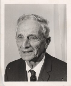 Rutherglen Historical Society
Photograph - Image, 1970s
Greatly relieved by his son’s safe return from war, John Richard Stanton (1872-1955) buys a parcel of productive farming land for his son John Charles “Jack” Stanton (1895-1989) to give him a “good start in life”. Jack’s wife Ethel Capper, devised the name “Gracerray” for the property to honour her sister Grace and the nearby Murray River. After the First World War, fourth generation Jack Stanton (1895-1989) with the help of his father started building a new winery (at the current site of the winery and cellar door) called ‘Gracerray’ named after his wife’s sister Grace and the Murray River. It is pronounced “Grah-sair-ray”. Jack built Gracerray around some existing cement open top vats from a winery that was demolished after phylloxera ravaged the region in the late 1890s. He used second hand materials from the defunct Great Southern gold mine and propped up the roof with huge tree trunks. Jack only made fortified wine up until the 1960s when he and his son-in-law Norman Killeen started making red wine to meet changing Australian tastes.Black and white portrait photograph of a mature man in suit and tie.On back of photo: "145% [upper case E in small circle] J.C. Stanton" wineries, north east victoria, wine industry, j c stanton, stanton & killeen winery, jack stanton -
Kew Historical Society Inc
Collection, Floods in North Kew (Series), 1929–1934
Flooding of the Yarra Valley, including that section of the Yarra bordering Kew and Kew East in the north and west of the municipality, was a regular occurrence. Extreme flood events of the Yarra River are recorded to have occurred in 1891, 1901, 1916, 1923 and 1934. The Municipality of Kew's response to these floods was to enact planning decisions restricting residential development in flood prone areas following the floods of 1916, 1921 and 1934. While floods continued after the development of the Upper Yarra Reservoir (construction 1948-57), the regularity and extent of these inundations diminished. Natural disasters had an impact on the development and settlement of Melbourne and its suburbs. Flooding in the Melbourne region was a regular event in the nineteenth and for most of the twentieth centuries. Changes in the impact of natural disasters could occur due to a number of factors. This collection of small snapshots, mostly taken from Kellett Grove in North Kew, provide provenanced evidence of flooding in the area before the development of the unnatural flood barrier that is the Eastern Freeway.Collection of 16 monochrome photographs, annotated on verso by different hands, of the flooding of the River Yarra in North Kew in the third and fourth decades of the twentieth century [1920s & 1930s]. Individual photos include the dates of different floods. Many of the photos were taken from the rear of 8 Kellett Grove; a house still extant in 2023yarra river -- north kew, floods -- yarra valley, floods -- north kew, floods -- 1929, floods -- 1934, natural disasters -- kew -
 Kew Historical Society Inc
Photograph - Flooding of the Yarra River in North Kew, 1934
North Kew, now divided between Kew and Kew East, bordered the Yarra River. As such, it was a region subject to flooding in the Yarra Valley. Development beyond this point (ie Kellett Grove) was limited by the City of Kew's planning regulations. Prior to urban development, the area since European settlement and the first land sales in the district in the 1840s, had been used for dairy farming. Small sepia snapshot taken from the river ramp of a house at 8 Kellett Grove, in what was then known as North Kew. The point of view is from a backyard looking towards Fairfield. Beyond the fence line are two almost submerged houses. A number of people are in a motor driven boat midstream. Fairfield at this period, (ie 1934) was noted for its limited river side development. Verso: 2/12/34 / TAKEN FROM OUR RAMPyarra river -- north kew, floods -- yarra valley, floods -- north kew, floods -- 1929, floods -- 1934, natural disasters -- kew -
 Kew Historical Society Inc
Photograph - 8 Kellett Grove, North Kew, 1929
North Kew, now divided between Kew and Kew East, bordered the Yarra River. As such, it was a region subject to flooding in the Yarra Valley. Development beyond this point (ie Kellett Grove) was limited by the City of Kew's planning regulations. Prior to urban development, the area since European settlement and the first land sales in the district in the 1840s, had been used for dairy farming. Small sepia snapshot taken of the front of 8 Kellett Grove, in what was then known as North Kew. Verso: 8 KELLETT GROVE / NORTH KEW / 1929 / 418 kellett gove -- north kew, californian bungalows, houses -- kellett grove -- kew (vic.) -
 Kew Historical Society Inc
Photograph - Flooding of the Yarra River in North Kew, 1934
North Kew, now divided between Kew and Kew East, bordered the Yarra River. As such, it was a region subject to flooding in the Yarra Valley. Development beyond this point (ie Kellett Grove) was limited by the City of Kew's planning regulations. Prior to urban development, the area since European settlement and the first land sales in the district in the 1840s, had been used for dairy farming. Small sepia snapshot taken from the back yard of a house at 8 Kellett Grove, in what was then known as North Kew. The point of view is from a backyard looking towards Fairfield. Floodwaters have submerged the fence and a clothes line. Verso: BACKYARD NTH. KEWyarra river -- north kew, floods -- yarra valley, floods -- north kew, floods -- 1934, natural disasters -- kew -
 Kew Historical Society Inc
Photograph - Flooding of the Yarra River in North Kew, 1934
North Kew, now divided between Kew and Kew East, bordered the Yarra River. As such, it was a region subject to flooding in the Yarra Valley. Development beyond this point (ie Kellett Grove) was limited by the City of Kew's planning regulations. Prior to urban development, the area since European settlement and the first land sales in the district in the 1840s, had been used for dairy farming. Small sepia snapshot taken from the back yard of a house at 8 Kellett Grove, in what was then known as North Kew. The point of view is from a backyard looking towards Fairfield. Verso: 8 KELLETT GROVEyarra river -- north kew, floods -- yarra valley, floods -- north kew, floods -- 1934, natural disasters -- kew -
 Kew Historical Society Inc
Photograph - Flooding of the Yarra River in North Kew, 1934
North Kew, now divided between Kew and Kew East, bordered the Yarra River. As such, it was a region subject to flooding in the Yarra Valley. Development beyond this point (ie Kellett Grove) was limited by the City of Kew's planning regulations. Prior to urban development, the area since European settlement and the first land sales in the district in the 1840s, had been used for dairy farming. Small sepia snapshot taken from the back yard of a house at 8 Kellett Grove, in what was then known as North Kew. The point of view is from a backyard looking towards Fairfield. Verso: OUR BACKYARD 8 KELLETT GROVEyarra river -- north kew, floods -- yarra valley, floods -- north kew, floods -- 1934, natural disasters -- kew -
 Kew Historical Society Inc
Photograph - View of the Yarra River from 8 Kellett Grove, North Kew, 1948
North Kew, now divided between Kew and Kew East, bordered the Yarra River. As such, it was a region subject to flooding in the Yarra Valley. Development beyond this point (ie Kellett Grove) was limited by the City of Kew's planning regulations. Prior to urban development, the area since European settlement and the first land sales in the district in the 1840s, had been used for dairy farming. The view from the rear of 8 Kellett Grove predates the construction of the Eastern Freeway so provides a rare view of the area before it was built.Small sepia snapshot taken from the back yard of a house at 8 Kellett Grove, in what was then known as North Kew. A tower of the Kew Asylum on the top left of the horizon assist the viewer to recognise that the land to the left of the river is in Kew and Studley Park.Verso: NORTH KEW 1948 / Stamped 51019yarra river -- north kew, kellett grove -- north kew -
 Kew Historical Society Inc
Photograph - Flooding of the Yarra River in North Kew, 1934
North Kew, now divided between Kew and Kew East, bordered the Yarra River. As such, it was a region subject to flooding in the Yarra Valley. Development beyond this point (ie Kellett Grove) was limited by the City of Kew's planning regulations. Prior to urban development, the area since European settlement and the first land sales in the district in the 1840s, had been used for dairy farming. Small sepia snapshot of floodwaters taken from near Kellett Grove, in what was then known as North Kew. The point of view is from a backyard looking towards Fairfield. In the foreground ar two men in a rowboat.Verso: OUR BACKYARD / Stamped 3 163yarra river -- north kew, floods -- yarra valley, floods -- north kew, floods -- 1934, natural disasters -- kew -
 Kew Historical Society Inc
Photograph - Flooding of the Yarra River in North Kew, 1934
North Kew, now divided between Kew and Kew East, bordered the Yarra River. As such, it was a region subject to flooding in the Yarra Valley. Development beyond this point (ie Kellett Grove) was limited by the City of Kew's planning regulations. Prior to urban development, the area since European settlement and the first land sales in the district in the 1840s, had been used for dairy farming. Small sepia snapshot of floodwaters taken from near Willsmere Road, in what was then known as North Kew. The point of view is looking towards Fairfield. In the foreground are two figures viewing a group in a rowboat in the middle of the flooded river. Semi-submerged street lighting indicates that entire streets had been. overwhelmed by the flood waters. Verso: WILLSMERE ROAD NORTH KEW / Stamped 3 163yarra river -- north kew, floods -- yarra valley, floods -- north kew, floods -- 1934, natural disasters -- kew, willsmere road -
 Kew Historical Society Inc
Photograph - Flooding of the Yarra River in North Kew, 1934
North Kew, now divided between Kew and Kew East, bordered the Yarra River. As such, it was a region subject to flooding in the Yarra Valley. Development beyond this point (ie Kellett Grove) was limited by the City of Kew's planning regulations. Prior to urban development, the area since European settlement and the first land sales in the district in the 1840s, had been used for dairy farming. Small sepia snapshot of floodwaters in North Kew. The point of view is of two houses belonging to local families that were surrounded by floodwater. Verso: HYATTS HOUSE / WILLSMERE ROAD / Stamped 3 163yarra river -- north kew, floods -- yarra valley, floods -- north kew, floods -- 1934, natural disasters -- kew, willsmere road -
 Kew Historical Society Inc
Photograph - Flooding of the Yarra River in North Kew, 1934
North Kew, now divided between Kew and Kew East, bordered the Yarra River. As such, it was a region subject to flooding in the Yarra Valley. Development beyond this point (ie Kellett Grove) was limited by the City of Kew's planning regulations. Prior to urban development, the area since European settlement and the first land sales in the district in the 1840s, had been used for dairy farming. Small sepia snapshot of floodwaters in North Kew, from the rear of 8 Kellett Grove. Verso: OUR BACKYARD / Stamped 52yarra river -- north kew, floods -- yarra valley, floods -- north kew, floods -- 1934, natural disasters -- kew, willsmere road -
 Kew Historical Society Inc
Photograph - Grandfather and granddaughter in the yard of 8 Kellett Grove, Kew, 1934
North Kew, now divided between Kew and Kew East, bordered the Yarra River. As such, it was a region subject to flooding in the Yarra Valley. Development beyond this point (ie Kellett Grove) was limited by the City of Kew's planning regulations. Prior to urban development, the area since European settlement and the first land sales in the district in the 1840s, had been used for dairy farming. Vivid photograph contrasting domestic life and relationships with natural disasters such as the flood of 1934.Small sepia snapshot of a grandfather and granddaughter sitting in the backyard of 8 Kellett Grove, North Kew, with the floodwaters stretching behind them.Verso: GRANDDAD AND I IN BACKYARDyarra river -- north kew, floods -- yarra valley, floods -- north kew, floods -- 1934, natural disasters -- kew, willsmere road -
 Kew Historical Society Inc
Photograph - Submerged houses in River Avenue, North Kew, 1934
North Kew, now divided between Kew and Kew East, bordered the Yarra River. As such, it was a region subject to flooding in the Yarra Valley. Development beyond this point (ie Kellett Grove) was limited by the City of Kew's planning regulations. Prior to urban development, the area since European settlement and the first land sales in the district in the 1840s, had been used for dairy farming. Vivid photograph contrasting domestic life and relationships with natural disasters such as the flood of 1934.Small sepia snapshot of two submerged houses belonging to local families in River Avenue, North Kew, during the 1934 floods. The view is presumably from near Kellett Grove looking north towards Fairfield.Verso: COES & HYATTS ROOF / RIVER AVENUE / Stamped: 6414yarra river -- north kew, floods -- yarra valley, floods -- north kew, floods -- 1934, natural disasters -- kew -
 Kew Historical Society Inc
Photograph - Flooding of the Yarra River in North Kew, 1934
North Kew, now divided between Kew and Kew East, bordered the Yarra River. As such, it was a region subject to flooding in the Yarra Valley. Development beyond this point (ie Kellett Grove) was limited by the City of Kew's planning regulations. Prior to urban development, the area since European settlement and the first land sales in the district in the 1840s, had been used for dairy farming. Vivid photograph contrasting domestic life and relationships with natural disasters such as the flood of 1934.Small sepia snapshot of the donors grandfather rescuing the family dog's kennel from rising floodwaters at the rear of 8 Kellett Grove, North Kew, .Verso: DAD SECURING NIPPY'S DOG KENNEL / Stamped 6414yarra river -- north kew, floods -- yarra valley, floods -- north kew, floods -- 1934, natural disasters -- kew -
 Kew Historical Society Inc
Photograph - Flooding of the Yarra River in North Kew, 1934
North Kew, now divided between Kew and Kew East, bordered the Yarra River. As such, it was a region subject to flooding in the Yarra Valley. Development beyond this point (ie Kellett Grove) was limited by the City of Kew's planning regulations. Prior to urban development, the area since European settlement and the first land sales in the district in the 1840s, had been used for dairy farming. .Small sepia snapshot of a local family's house in what was then River Avenue, North Kew being surrounded by floodwaters.Verso: THE SIDE OF RYANSyarra river -- north kew, floods -- yarra valley, floods -- north kew, floods -- 1934, natural disasters -- kew -
 Kew Historical Society Inc
Photograph - Flooding of the Yarra River in North Kew, 1934
North Kew, now divided between Kew and Kew East, bordered the Yarra River. As such, it was a region subject to flooding in the Yarra Valley. Development beyond this point (ie Kellett Grove) was limited by the City of Kew's planning regulations. Prior to urban development, the area since European settlement and the first land sales in the district in the 1840s, had been used for dairy farming. .Small sepia snapshot of what was then River Avenue, North Kew submerged by floodwaters.The photo was taken in the vicinity of 8 Kellett Grove, North Kew. Verso: TAKEN FROM OUR STREET JUST SEE A BIT OF RYAN'S FENCE / 1934yarra river -- north kew, floods -- yarra valley, floods -- north kew, floods -- 1934, natural disasters -- kew -
 Kew Historical Society Inc
Photograph - Flooding of the Yarra River in North Kew, 1934
North Kew, now divided between Kew and Kew East, bordered the Yarra River. As such, it was a region subject to flooding in the Yarra Valley. Development beyond this point (ie Kellett Grove) was limited by the City of Kew's planning regulations. Prior to urban development, the area since European settlement and the first land sales in the district in the 1840s, had been used for dairy farming. .Small sepia snapshot of the devastation caused by the 1934 flood.The photo was taken in the vicinity of Kellett Grove, North Kew and includes the roof of Chipperfield's Boathouse as well as other local houses.Verso: THIS IS CHIPPERFIELD'S BOAT SHEDS & COES & WILLIAMS TAKEN FROM OUR STREET / 1934yarra river -- north kew, floods -- yarra valley, floods -- north kew, floods -- 1934, natural disasters -- kew, chipperfields boathouse -
![Hand-Drawn Map Centred on Chiltern by Frank Lebbell Frost [ca 1915-1918]](/media/collectors/51d110e42162ef12e06aa06b/items/51fb08452162ef156c79a623/item-media/52a11e6d2162ef1f0c9c0af4/item-fit-380x285.jpg) Beechworth Honey Archive
Beechworth Honey ArchiveHand-Drawn Map Centred on Chiltern by Frank Lebbell Frost [ca 1915-1918]
This is one of the maps drawn by Frank L. Frost while he was beekeeping in North-East Victoria. This particular map may be reference in the "Wooden" Diary on pages 12, 13 and 17.Front Side: Hand-drawn map centred on Chiltern showing the Melbourne road [Hume Freeway] and the Beechworth-Rutherglen road with detailed locations of flora in the region. Flora includes; Iron Bark, Stringy Bark, Red Box and Yellow Box. Details regarding quantity of flowers and quality of trees is included. Back Side: Some names and addresses are recorded in pencil. Drawn with black pen and grey lead on paper. A grid and other symbols are marked in red ink.hand drawn, hand-drawn, map, chiltern, 1915, beekeeper, frost, beechworth honey -
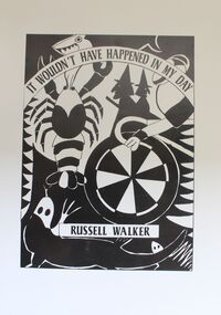 Wodonga & District Historical Society Inc
book - It Wouldn't Have Happened in My Day, Russell Walker, 1997
... of Victoria. North East Victoria Upper Murray Region poetry ...An anthology of poetry dedicated to " those former primary students of the North East / Upper Murray Region of Victoria whose ideas and imaginations are indirectly responsible for many of the poems printed in this volume."An anthology of poetry. It consists of 73 pages including black and white Illustrations stapled down the centre.fictionAn anthology of poetry dedicated to " those former primary students of the North East / Upper Murray Region of Victoria whose ideas and imaginations are indirectly responsible for many of the poems printed in this volume."north east victoria, upper murray region, poetry -
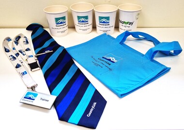 Wodonga & District Historical Society Inc
Memorabilia - CountryLink Collection
For residents of Northeast Victoria, railway services have provided a critical link between the area and state capital cities. CountryLink was established in January 1989 under the Transport Administration Act 1988. It was a passenger rail and road service brand that operated in regional areas of New South Wales, and to and from Canberra, Brisbane and Melbourne. CountryLink operated rail services a fleet of XPT and locomotive-hauled passenger trains. The Southern region of the Country Link network covered New South Wales districts of Illawarra, South Coast, Snowy Mountains, South West Slopes, Southern Tablelands, Riverina and Sunraysia regions plus the Australian Capital Territory and parts of Victoria. The Government of Victoria contributed to the provision of these services. Services ran along the Main South line from Sydney Central station to Albury before continuing on the North East line to Southern Cross station in Melbourne. The Sydney/Melbourne Express ceased in November 1993 and was replaced by an XPT in November 1993 In December 1994, a daylight service to Melbourne resumed by extending the Riverina XPT from Albury. In July 2013, CountryLink was merged with the intercity services of CityRail to form NSW TrainLink.These items are connected to a major transportation system in eastern Australia.A collection of uniform items and memorabilia from the CountryLink rail service. They include a tie and tiepin, staff badge and lanyard, cups and a bag with CountryLink logo.Tag on tie: Stylecore Corporate Wear Australia/ Polyester/ Made in England On all items: CountryLinkcountrylink, australian railways, countrylink uniforms