Showing 1349 items matching "north park"
-
 Tennis Australia
Lithograph , Page from Magazine, 05 Oct 1889
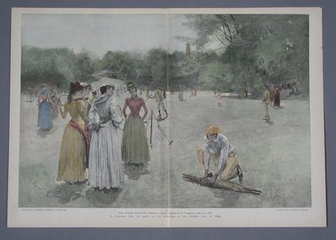
... to Harper's Weekly, entitled: THE NORTH MEADOWS, CENTRAL PARK...Tennis Australia Melbourne Park Olympic Boulevard Melbourne ...A colour lithographic print, liftout from Supplement to Harper's Weekly, entitled: THE NORTH MEADOWS, CENTRAL PARK. Materials: Ink, Papertennis -
 Glenelg Shire Council Cultural Collection
Photograph - Photograph - Canal Bridge Construction, Portland, n.d
... , Portland. Taken from elevated position looking north across Henty... position looking north across Henty Park to Portland. Photograph ...Port of Portland Authority Archivesport of portland archives, canal bridge, construction, henty park, harbour development -
 Whitehorse Historical Society Inc.
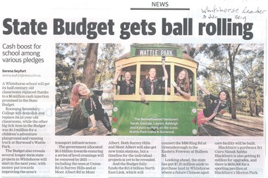
Article, State Budget Gets Ball Rolling, 2019
... for Koonung Secondary College, Morton Park, North East Link... Morton Park Blackburn Sikh Temple Blackburn North East Link ...The State Government budget has included allocations for Koonung Secondary College, Morton Park, North East Link and the Blackburn Sikh Temple.The State Government budget has included allocations for Koonung Secondary College, Morton Park, North East Link and the Blackburn Sikh Temple.The State Government budget has included allocations for Koonung Secondary College, Morton Park, North East Link and the Blackburn Sikh Temple.koonung secondary college, secondary schools, morton park, blackburn, sikh temple, blackburn, north east link -
 Melbourne Tram Museum
Photograph - TV interview scene with SW6 class tram as prop
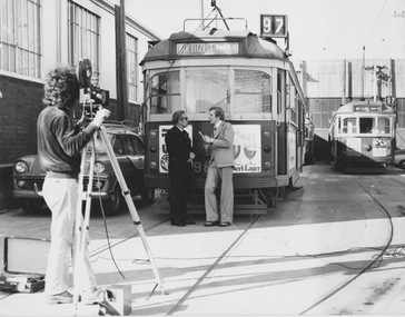
... tram as prop displaying destination 'North Fitzroy - Park St 97... tram as prop displaying destination 'North Fitzroy - Park St 97 ...TV interview scene at North Fitzroy Depot with SW6 class tram as prop displaying destination 'North Fitzroy - Park St 97'. The cameraman, interviewer and uniformed driver are featuredYields information about publicity of tramwaysBlack and white photograph, no detailstrams, publicity, televsion, w class, north fitzroy depot -
 Melbourne Tram Museum
Photograph - Black & White Photograph/s, c1956
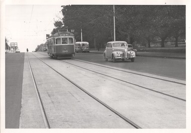
... Carlton, route 97, mid 1950's. Tram has the destination of North..., route 97, mid 1950's. Tram has the destination of North Fitzroy ...Black and White photograph of W7 1021 in Nicholson St Carlton, route 97, mid 1950's. Tram has the destination of North Fitzroy Park St. In the background are a number of vehicles including a bus - see image htd4436ib.jpg for a close up.trams, tramways, nicholson st, w7 class, buses, route 97, tram 1021 -
 Whitehorse Historical Society Inc.
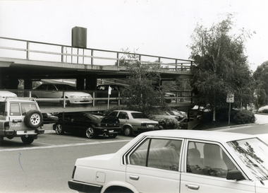
Photograph, Mitcham Car Park, 5/01/2001 12:00:00 AM
... Black and white photo of Mitcham Mall Multi-Storey Car Park... of Mitcham Mall Multi-Storey Car Park at north end of Mall. Mitcham ...Black and white photo of Mitcham Mall Multi-Storey Car Park at north end of Mall.britannia mall mitcham -
 Buninyong & District Historical Society
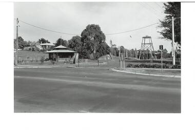
Photograph - Original B/W Photograph, De Soza park, Warrenheip St., Buninyong, with poppet head, rotunda and Chilean Wheel sculpture
... Original B/W photograph of streetscape of De Soza park..., large cypress tree to north of park. De Soza park, Warrenheip St ...De Soza park was developed as a public amenity from the early 1980s. The poppet head and Chilean wheel sculpture are representative of the gold mining origins of the town.The park, located centrally in Buninyong is of social and historic significance.Original B/W photograph of streetscape of De Soza park frontage to Warrenheip St., Buninyong, with poppet head, rotunda and Chilean Wheel sculpture, former post office in background. Large eucalypt tree present behind rotunda, large cypress tree to north of park.buninyong, de soza, park, rotunda, poppet head, sculpture, chilean wheel, post office, warrenheip st, streetscape -
 Tennis Australia
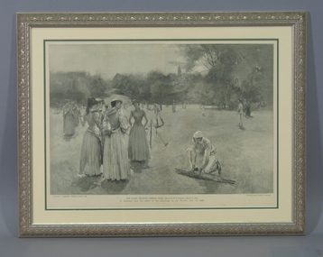
Page from Magazine, 1889
... Reproduction of Lithograph 'The North Meadows, Central Park... 'The North Meadows, Central Park' by W.T. Smedley, reproduced ...Reproduction of Lithograph 'The North Meadows, Central Park' by W.T. Smedley, reproduced in Supplement to Harper's Weekly, October 5th, 1889. Materials: Ink, Cardboard, Glass, Papertennis -
 Kew Historical Society Inc
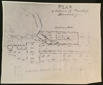
Print - Subdivision Plan (copy), Plan of Section 79 Parish of Boroondara (Clifton Estate), Nineteenth Century
... represent the first land sales in Kew in the area north of Studley... in the area north of Studley Park Road. Plan of Section 79 Parish ...This work forms part of the collection assembled by the historian Dorothy Rogers, that was donated to the Kew Historical Society by her son John Rogers in 2015. The manuscripts, photographs, maps, and documents were sourced by her from both family and local collections or produced as references for her print publications. Many were directly used by Rogers in writing ‘Lovely Old Homes of Kew’ (1961) and 'A History of Kew' (1973), or the numerous articles on local history that she produced for suburban newspapers. Most of the photographs in the collection include detailed annotations in her hand. The Rogers Collection provides a comprehensive insight into the working habits of a historian in the 1960s and 1970s. Together it forms the largest privately-donated collection within the archives of the Kew Historical Society.A photographic reproduction of a plan in the Vale Collection of the State Library of Victoria. The numbered lots represent the first land sales in Kew in the area north of Studley Park Road.maps (kew), plan of section 79 parish of boroondara -
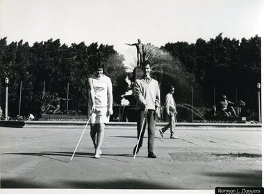 Vision Australia
Photograph - Image, Navigating the Archibald Fountation, 1970?
... A young lady and man use white canes to navigate Hyde Park... A young lady and man use white canes to navigate Hyde Park North ...A young lady and man use white canes to navigate Hyde Park North in Sydney, in front of the Archibald fountain.B/W photograph of two people using canes10/70103 M&O - Historical Mobility - historicalroyal blind society of nsw, white cane day -
 Eltham District Historical Society Inc
Photograph - Aerial Photograph, Landata, Eltham, Vic, Apr. 1972
... , Eltham bounded by Allendale Road to north, Park West Road..., Eltham bounded by Allendale Road to north, Park West Road ...Centred on present day Zig Zag Road near Coolabah Drive, Eltham bounded by Allendale Road to north, Park West Road to south, Parsons Road to east and Banks Road to west. Historic Aerial Imagery Source: Landata.vic.gov.au Aerial Photo Details: Project No :985 Project : MELBOURNE 1972 Run : 26 Frame : 191 Date : 04/1972 Film Type : B/W Camera : RC10 Flying Height : 5700 Scale : 9600 Film Number : 2636 GDA2020 : 37°41'56"S, 145°09'26"E MGA2020 : 337533, 5826000 (55) Melways : 22 A1 (ed. 42)aerial photo, neil webster collection, 1972-04, allendale road, eltham, eltham north, zig zag road, banks road, coolabah drive, melway 22a1, park west road, parsons road -
Lakes Entrance Historical Society
Album - Photograph, Judy Davies, Small album of North Arm Bridge Lakes Entrance Victoria, 2000 c
... of North Arm Apex Park to Eastern Creek Bay Lakes Entrance Victoria... and sixteen colour photographs of North Arm Apex Park to Eastern Creek ...Small album containing fourteen colour photographs of construction of North Arm Bridge and sixteen colour photographs of North Arm Apex Park to Eastern Creek Bay Lakes Entrance Victoriaboats and boating, historic sites -
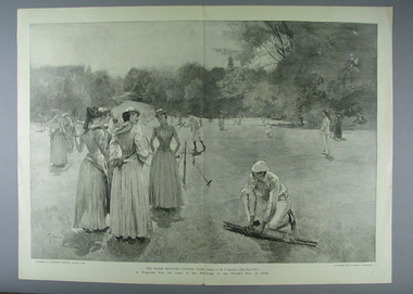 Tennis Australia
Page from Magazine, 05 Oct 1889
... by W.T. Smedley, entitled 'The North Meadows, Central Park...Tennis Australia Melbourne Park Olympic Boulevard Melbourne ...A lift-out poster from an issue of Harper's Weekly Supplement (5 October 1889), featuring a reproduction of a lithograph by W.T. Smedley, entitled 'The North Meadows, Central Park'. Materials: Paper, Inktennis -
 Kew Historical Society Inc
Photograph - Flooding of the Yarra Valley at Kew East, 1974
... . The photograph is of Hyde Park looking north-east.... May 1974. The photograph is of Hyde Park looking north-east ...Flooding of the Yarra Valley, including that section of the Yarra bordering Kew and Kew East in the north and west of the municipality, was a regular occurrence. Extreme flood events of the Yarra River are recorded to have occurred in 1891, 1901, 1916, 1923 and 1934. The Municipality of Kew's response to these floods was to enact planning decisions restricting residential development in flood prone areas following the floods of 1916, 1921 and 1934. While floods continued after the development of the Upper Yarra Reservoir (construction 1948-57), the regularity and extent of these inundations diminished. During the nineteenth century, the land abutting the south side of the Yarra in Kew was devoted to dairy farming. In the twentieth century, before and after the construction of the Eastern Freeway, much of this low-lying area was used as golf courses and public parks.Late example of the capacity of the Yarra Valley at Kew to flood, even though drainage works and the Upper Yarra Reservoir had reduced their regularity.Original black and white print photograph of the low-lying land at East Kew under floodwater on 16 May 1974. The photograph is of Hyde Park looking north-east.Annotation verso: "Hyde Park looking nth-east / Flood Level / 16 May 1974 11.15am / R.L. 46.61"floods, yarra river, hyde park -
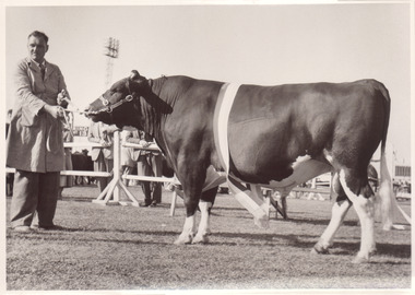 Melbourne Royal
Photograph, Frank Johnson, 1954
... "Kingstone Park" Merricks North... "Kingstone Park" Merricks North... "Kingstone Park" Merricks North This item is a part of a larger ...Black and white photograph of a Champion Friesian Bull Champion Friesian Bull. Glenhope Keystone Burkeyje. FJ Fox "Kingstone Park" Merricks NorthThis item is a part of a larger collection of 4,500 Frank Johnson photographs and negatives donated to Melbourne Royal by Frank Johnson’s daughter, Francis Beatty Wallace in 2016. This collection spanning from the 1930s to the 1980s holds important social and historical significance in preserving and sharing Victoria’s agricultural history and community. The photographs capture the local, regional, and state’s shared relationships developed through agriculture and the importance of farming and husbandry to the population and development of Australia. A large proportion of these photographs depict events from the Royal Melbourne Show, including livestock competitions, exhibitions and awards ceremonies. Dating back to 1848 when the society first began, the Royal Melbourne Show has held a special place in the hearts and minds of Victorians, allowing for extensive showcasing and celebration of agricultural excellence, bridging the divide between metropolitan and rural Victoria.A black and white photograph, landscape, printed on gloss paper with a white borderChampion Friesian Bull. Glenhope Keystone Burkeyje. FJ Fox "Kingstone Park" Merricks Northroyal melbourne show, friesian, bull, agricultural shows, blue ribbon competitions, winners, glenhope, kingstone, fj fox, fox -
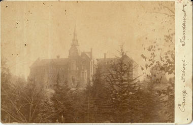 Bendigo Historical Society Inc.
Photograph - CAMP SCHOOL SANDHURST
... Rosalind Park looking north towards school. Trees in foreground..., Sandhurst; Photo taken from Rosalind Park looking north towards ...sepia photo: Camp School, Sandhurst; Photo taken from Rosalind Park looking north towards school. Trees in foreground. School now known as Camp Hill Primary School.place, building, camp school sandhurst -
 Stawell Historical Society Inc
Photograph, Aerial Photos of Stawell from a Hot Air Balloon 1985 -- 12 Photos
... . 3. North Park Area Lamont St. 4. Netball & Tennis courts.... 3. North Park Area Lamont St. 4. Netball & Tennis courts ...Series of 12 Aerial Photos of Stawell. Hot Air Balloon 1985. Photos taken during hot air balloon rides May & June 1935. The rides left from land near leisure complex, Houston St and Newington Rd corner. The rides first over Stawell and drifted towards the Black Range. This vacant site is now the location of Stawell indoor heated and outdoor pools. 1 & 2. Setting up balloon. 3. North Park Area Lamont St. 4. Netball & Tennis courts Athletic track. 5 Wimmera St, Trotting track & Drive-in Scallan St. & Main St. 6. State School 502 Jenning-Campbell & Houston St's. 7 Ligar St. crosses Campbell & Houston St's. 8. Ord St, 502 School yard. 9. Central Park Napier, Wakeham & Shirreff St's also Railway & Foot Bridge. 10. Central Park. 11. Sloane St. on left Trotting track & Drive-in. 12. The Old Lake oval. Series of twelve photos mostly consisting of aerial photos and two of a large balloon on the ground. stawell -
 Lakes Entrance Historical Society
Photograph - The Entrance, Fraser Ian, 1995c
... and the entrance to North Arm, cars parked on island and many people... to North Arm, cars parked on island and many people fishing ...Colour photograph of the entrance from Bass Strait to the Gippsland Lakes. It shows the western end of Bullock Island and the entrance to North Arm, cars parked on island and many people fishing. This area built up during dredging operations over many years. Lakes Entrance Victoria topography, fishing industry, boats and boating -
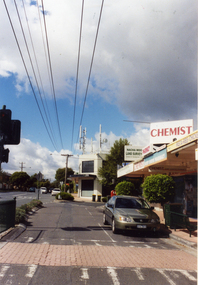 Whitehorse Historical Society Inc.
Photograph, Mitcham North Shopping Centre, 2006
... Coloured Photo of Mitcham North Shopping Centre (opposite... Mitcham melbourne mitcham north shopping centre shops shopping ...Coloured Photo of Mitcham North Shopping Centre (opposite Park Road) looking south. Communications towers situated on roof of a security service building. Land surveyor and chemist on right (west side ).mitcham north shopping centre, shops, shopping centre -
 Warrnambool and District Historical Society Inc.
Administrative record (collection) - Documents relating to house in Warrnambool, 1951
... built in that area of Warrnambool north of Albert Park... built in that area of Warrnambool north of Albert Park ...Collection maintained by daughter of original owner.Historical reasonsCollection of items in folder in chronological orderCorrespondence from Government and legal sourceswarrnambool housing post world war twowarrnambool housing post world war two -
 Lakes Entrance Historical Society
Photograph - Whiter's Camp Park, Bulmer H D, 1935
... north from Roadknight Street, showing layout of park including... Park, looking north from Roadknight Street, showing layout ...Black and white aerial view of Whiters Camp Park, looking north from Roadknight Street, showing layout of park including tennis courts, bowling green, picnic area, cottages, rotunda, and the family residence. Lakes Entrance Victoria tourism, camping -
 Kew Historical Society Inc
Photograph - Opening of the Dorothy Rogers Reserve, 1976
... of the Society. The reserve is located on the north side of Studley Park... of the Society. The reserve is located on the north side of Studley Park ...Dorothy Rogers wrote two major books on Kew's history: Lovely Old Homes of Kew (1961) and A History of Kew (1973). In addition to her published works, she was a regular contributor on issues of local history to suburban newspapers. Her archives are held in the collections of the State Library of Victoria and Kew Historical Society. Three years after her death in 1973, the Reserve was opened in her honour.Faded colour positive photograph of the opening of the Dorothy Rogers Reserve in 1976. The naming of the reserve honoured the contribution of the historian Dorothy Rogers, foundation member of the Society. The reserve is located on the north side of Studley Park Road just west of Kew Junction. Inscribed verso: "Members and relatives of the late Dorothy Rogers. Memorial reserve named and unveiled in her honour by (Cr Whiting Mayor) and City Manager Mr Fell 1978. In respect for her great research and service to the history of early Kew, and other places."dorothy rogers reserve, public parks -- kew (vic.) -
 Kew Historical Society Inc
Photograph - Opening of the Dorothy Rogers Reserve, 1976
... of the Society. The reserve is located on the north side of Studley Park... of the Society. The reserve is located on the north side of Studley Park ...Dorothy Rogers wrote two major books on Kew's history: Lovely Old Homes of Kew (1961) and A History of Kew (1973). In addition to her published works, she was a regular contributor on issues of local history to suburban newspapers. Her archives are held in the collections of the State Library of Victoria and Kew Historical Society. Three years after her death in 1973, the Reserve was opened in her honour.Faded colour positive photograph of the opening of the Dorothy Rogers Reserve in 1976. The naming of the reserve honoured the contribution of the historian Dorothy Rogers, foundation member of the Society. The reserve is located on the north side of Studley Park Road just west of Kew Junction. Inscribed verso: "Left to right: Mrs Rogers Jnr, Joy Stewart, Miss Jenkins sitting / Mrs Richardson and Mr Richardson, Brother of D. Rogers), Mayor Cr Whiting, City Manager Mr Fell, Background / KHS President Miss Hall, Mr B O'Neill KHS member, / taken during the memorial unveiling of the Dorothy Rogers Reserve"dorothy rogers reserve, public parks -- kew (vic.) -
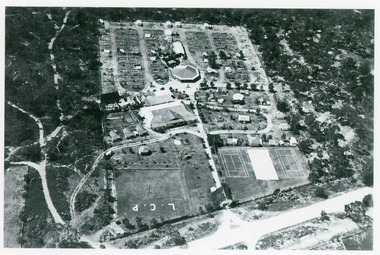
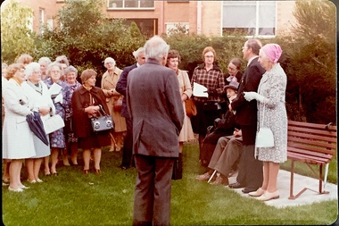
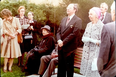
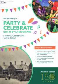 Greensborough Historical Society
Pamphlet, Leith Park Celebration Day 2019 program, 20/10/2019
... retirement village at Rushall Park North Fitzroy was held on 20... Association of Victoria retirement village at Rushall Park North ...A celebration for the 150th anniversary of the establishment of the first Old Colonists Association of Victoria retirement village at Rushall Park North Fitzroy was held on 20 October 2019 at Leith Park St Helena. Leith Park was the Association's second village, built in the 1960s on land donated by Arthur C. Leith, Life Governor, Councillor and President of the Association 1949-1972.4 p. colour pamphlet printed on light cardboardleith park retirement village, old colonists association -
 Melbourne Tram Museum
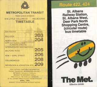
Ephemera - Timetables - The Met - buses - set of 2, The Met, 1984 and 1985
... - April 1984 2 - St Albans - Deer Park North Shopping Centre..., with a description of the route and a map. 1 - Bulleen - North Kew - City ...Timetables - provide information on ticketing, fares, timing points, with a description of the route and a map. 1 - Bulleen - North Kew - City, Belford Rd, Collingwood - routes 203, 204, 205, 206, 208, 209 - with the first "The Met" logo - April 1984 2 - St Albans - Deer Park North Shopping Centre - circular route - with the smiley face on wheels logo - dated 18/3/1985.Yields information about MMTB Bus services during the mid 1980s. Set of two The Met timetables, one printed on the folded sheet of yellow paper and the other on white paper.timetable, bulleen, north kew, collingwood, the met, deer park, st albans -
 Lakes Entrance Historical Society
Photograph - Apex Park Lakes Entrance Victoria, M Holding, 1985 c
... Island Apex Park beside North Arm in foreground has old...The town section of North Arm previously known ...The town section of North Arm previously known as The Backwater Road Colour photograph taken from Kalimna Heights showing outer barrier and entrance channel. Road and new bridge to Bullock Island Apex Park beside North Arm in foreground has old playground equipment with timber fort and hillock with underground tunnel Lakes Entrance Victoria topography, waterways, parks, bullock island -
 Ballarat Tramway Museum
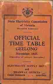
Ephemera - Timetable, State Electricity Commission of Victoria (SECV), "Official Timetable Geelong", November 1937
... , East Geelong, Chilwell, Eastern Park, Belmont,, North, Dated..., East Geelong, Chilwell, Eastern Park, Belmont,, North, Dated ...Gives details of the fares, transfers, luggage or parcels, lost property, times of each tram on the Newtown, West Geelong, East Geelong, Chilwell, Eastern Park, Belmont,, North, Dated Nov. 1937. Has adverts for SEC domestic appliances eg toasters, refrigerators and hot water.Yields information the 1937 tramway services in Geelong and SECV advertising domestic appliances.Printed booklet - was centre stapled - part of two timetables included within one cover. One loose sheet.secv, tramways, geelong, timetables -
 Whitehorse Historical Society Inc.
Photograph, Car Park - rear of Recreation Centre, 1/06/2009
... . This photograph is of the car park on north side of railway line and west... and the Springvale Road Railway crossing. This photograph is of the car park ...One of a collection of photographs taken of the Nunawading Railway Station prior to the lowering of the railway line and building of the new railway station on the western side of Springvale Road so that the Springvale Road Rail Crossing can be eliminated.Black & white photograph of he precinct surrounding the Nunawading Station and the Springvale Road Railway crossing. This photograph is of the car park on north side of railway line and west side of Springvale Road behind the Recreation Centre. This will be site of new station. See NP 3545 to NP3567 for the complete set of photographsnunawading railway station, springvale road nunawading, redevelopment of railway line/springvale road. -
 Greensborough Historical Society
Newspaper, The Chronicle Newspaper Group, The Bundoora Chronicle - Semper Paratus. Edition 01/22. October 2022, 2022_10
... was distributed to Mill Park, Watsonia North, Greensborough, Yallambie..., the Bundoora Chronicle was distributed to Mill Park, Watsonia North ...First published in 2022, the Bundoora Chronicle was distributed to Mill Park, Watsonia North, Greensborough, Yallambie, Watsonia, Macleod, Kingsbury. During the pandemic in 2020, most local papers ceased production. Unfortunately, although named the Bundoora Chronicle, this newspaper holds no local news and is more an advertising feature for greater Melbourne.Newspaper, 20 pages. Black text, colour and black and white images. 2 copiesnewspapers - melbourne, local newspapers -
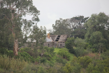 Victorian Interpretive Projects Inc.
Photograph - colour, Lisa Gervasoni, Ruins of Angus McMillan's original Bushy Park Homestead near Maffra, 2014, 07/06/2014
... a pastoral run at Bushy Park, north-west of the township. William... established a pastoral run at Bushy Park, north-west of the township ...Angus McMillan named the Avon River after the river of the same name in his native Scotland. In 1840 he established a pastoral run at Bushy Park, north-west of the township. William Odell Raymond established a run in the area in 1842, and built his house, Strathfieldsaye, during 1848–54. European settlement did not take place without resistance, and in return, massacres were inflicted by Angus McMillan and others on Gunai people, especially between the years of 1840 and 1850. (wikipedia)bushy park, angus mcmillan, avon river