Showing 24284 items matching "oceans"
-
 Glenelg Shire Council Cultural Collection
Photograph - Photograph - Early Shipping: Ocean/Railway Pier, n.d
Port of Portland Authority Archivesport of portland archives, portland harbour, driving piles, ocean pier -
 Torquay and District Historical Society
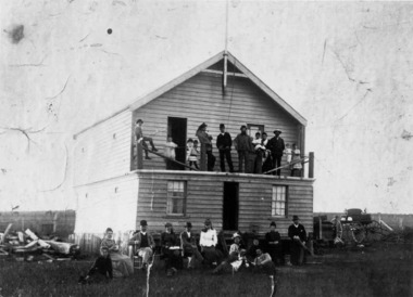
Black & White Photograph, Legacy of the storm ,Scammell house
Private residenceFamily photo in front of house looking towards the oceanshipwrecks great ocean road victoria -
 Torquay and District Historical Society
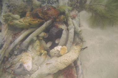
colour photograph, Scammell Collection
underwater photo of items from wreck on the ocean floorwreck of joseph h scammell -
 Ballarat Heritage Services
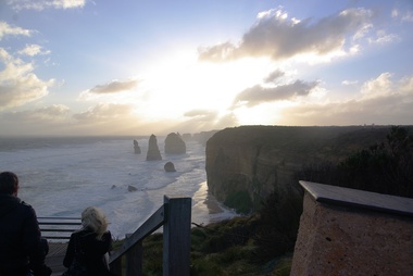
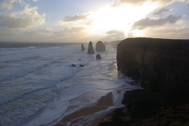
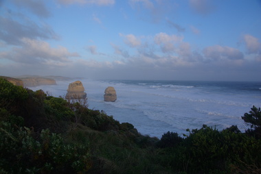
Photograph, L.J. Gervasoni, Twelve Apostles, Great Ocean Road, 2011, 10/07/2011
Colour photograph of the Twelve Apostles on the Great Ocean Road.great ocean road, twelve apostles, beach, great ocean raod -
 Ballarat Heritage Services
Photograph, L.J. Gervasoni, Twelve Apostles, Great Ocean Road, 2011, 10/07/2011
Colour photograph of the Twelve Apostles on the Great Ocean Road.great ocean road, twelve apostles, beach, shipwreck coast -
 Ballarat Heritage Services
Photograph, L.J. Gervasoni, Twelve Apostles, Great Ocean Road, 2011, 10/07/2011
Colour photograph of the Twelve Apostles on the Great Ocean Road.great ocean road, twelve apostles, beach -
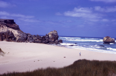
 Port Fairy Historical Society Museum and Archives
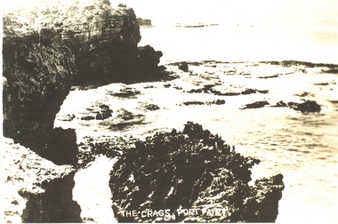
Postcard, "The Crags", c. 1930
The crags- Circa 1930Photograph Rocky area with ocean waves washing over The crags Port Fairy the crags, rocks, sea, ocean, princes highway -
 Port Fairy Historical Society Museum and Archives
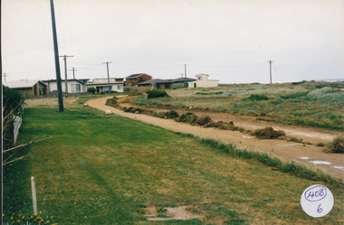
Photograph
South Beach Development Coloured photograph of Ocean Drive being graded and widened408/6 since been removed (2021)south beach, development, road making, ocean drive -
 Lakes Entrance Historical Society
Photograph - The Entrance, 1995c
Colour photograph showing the entrance to the Gippsland Lakes from the ocean, Bass Strait, with fishing boat crossing the entrance, the ocean breaking on the bar outside. Lakes Entrance Victoriawaterways, ships and shipping -
Glenelg Shire Council Cultural Collection
Negative - Negative - Portland, Victoria, Zilah Maschmedt, c. 1934
Negative for a black and white photograph. Image taken from Henty Beach, looking toward Ocean Pier, bathing shed, pier (the Slip) in foreground, Railway Pier, and Ocean Pier. -
 Lakes Entrance Historical Society
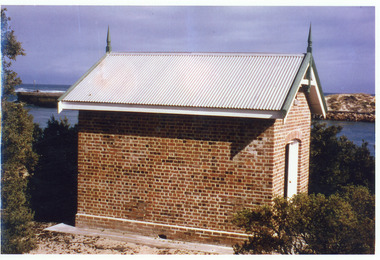
Photograph - Rocket Shed, 1997 c
Rocket shed (built 1890) was used to store rockets used to warn ships coming through the entrance of dangerous conditions.Colour photograph showing brick rocket shed on sand dune at the entrance to the ocean. Scrub around shed, entrance and western pier behind and ocean in distance. Lakes Entrance Victoriaships and shipping, historic buildings -
 Orbost & District Historical Society
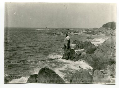
black and white photograph, first half 20th century
This is a photograph of a man fishing off the rocks at Cape Conran in Far East Gippsland.Cape Conran has always been a popular fishing destination for Orbost people. This photograph is a pictorial record of that recreational activity in the early 20th century. A black / white photograph of a man fishing from rocks into the ocean. -
 Lorne Historical Society
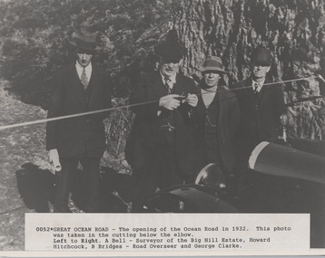
Photograph, Opening of Great Ocean Road by Howard Hitchcock 1932
A. Bell, surveyor,Photograph of Opening of Great Ocean Road 1932 by Howard Hitchcockgor opening 1932. a. bell surveyor. big hill estate. howard hitchock. george clarke -
 Lorne Historical Society
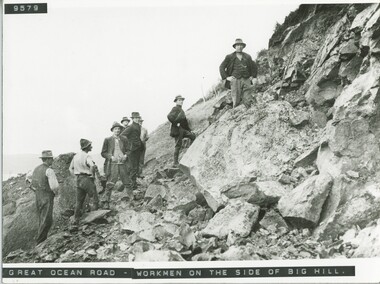
Photograph, Workmen at Big Hill
Photograph of a group of workmen at Big Hill on the Great Ocean Roadg.o.r; big hill: -
Glenelg Shire Council Cultural Collection
Photograph - Photograph - Ocean Pier Portland Harbour, Victoria, n.d
Black and white photo of Ocean Pier, taken from shoreBack: Purple round stamp "PRINTED BY M.E. ANDREWS PORTLAND" -
Glenelg Shire Council Cultural Collection
Photograph - Photograph - Doric berth at the Ocean Pier, 1952
Port of Portland Authority ArchivesFront: '10/5' - ink, top left Back: Purple PHT stamp Printed 10/5 Neg No 101 Date taken 23.12.52 Subject Cargo Ship 'Doric' at Deepwater Pier ---details in black ink -
Glenelg Shire Council Cultural Collection
Photograph - Photograph - Early Shipping: Ocean/Railway Pier, n.d
Port of Portland Authority Archivesport of portland archives, portland harbour, ship berthed, ocean pier, athel prince -
 Robin Boyd Foundation
Slide, Robin Boyd, 1970
Colour slide in a mount. Great Ocean Road, Victoria, AustraliaMade in Australia / 14 / APR 70M2slide, robin boyd -
 Robin Boyd Foundation
Slide, Robin Boyd, 1970
Colour slide in a mount. Great Ocean Road, Victoria, AustraliaMade in Australia / 13 / APR 70M2slide, robin boyd -
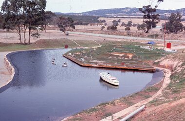 Stawell Historical Society Inc
Photograph - Slides, Stawell World in Miniture
Lake at stawell World in miniture with ocean liner and other boats -
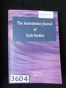 Stawell Historical Society Inc
Book, Irish Studies Association, The Australasian Journal of Irish Studies. Vol 7 - Previously Cat No 3604, 2008-2008
Card Cover with pink/mauve cover with ocean, and white writing The Australasian Journal of Irish Studies volume 7 2007/8stawell, ireland -
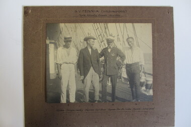 Seaworks Maritime Museum
Photograph
Photograph of the S.V Fennia crew on board "S.V Fennia (Helsingfors)/ North Atlantic Ocean Nov 1926" -
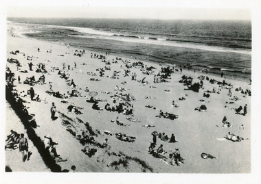 Lakes Entrance Historical Society
Postcard - Ocean Beach, 1950c
2nd postcard the same image, 3rd postcard tinted, same imageBlack and white small format postcard of a crowd of people on the ocean beach. It shows portion of a brush windbreak fence, large expanse of sandy beach, & Southern Ocean. Lakes Entrance Victoriarecreation, beaches -
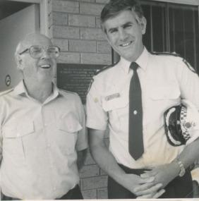 Lakes Entrance Historical Society
Photograph, Lakes Post Newspaper, 1991
The catamaran Parledee purchased 1982, was replaced by the Tyrell 1995.Black and white photograph, Neville Jakins, President of the Ocean Rescue Squad, with Robert Haldane, from Victoria Police, at the opening of the Ocean Rescue Squad new buildings. Lakes Entrance Victoriaemergency services, buildings -
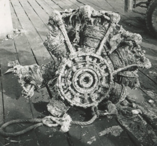 Lakes Entrance Historical Society
Photograph - Aircraft engine found by fishing boat Anne Liese Lakes Entrance 1993
part of an aircraft engine dredged up from the ocean floor four nautical miles west of the Entrance by fishing boat Anne Liese, skipper Matt Jenkins pictured on Eastern Wharf Lakes Entrance Victoria 1993 Also black and white photograph of two adults and three children watching activities of the fishing fleet at the wharf Black and white photograph of part of an aircraft engine dredged up from the ocean floor four nautical miles west of the Entrance by fishing boat Anne Liese, skipper Matt Jenkins pictured on Eastern Wharf Lakes Entrance Victoria. Also black and white photograph of two adults and three children watching activities of the fishing fleet at the wharf 1993 boats and boating, aircraft, discovery -
Port Melbourne Historical & Preservation Society
Photograph - Japanese warships and passenger liner, Ocean Monarch, Station Pier, Port Melbourne, Douglas Smallpage, 1970s
(15) B&W photographs of various Japanese warships and passenger liner "Ocean Monarch" at Station Pier in the 1970s .06 "Kikuzuki" (165) Japanese destroyer .14 "Ocean Monarch" passenger linerpiers and wharves - station pier, ocean monarch, kikuzuki- japanese destroyer -
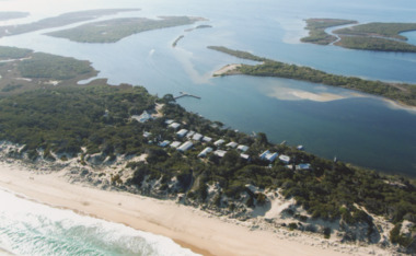 Lakes Entrance Historical Society
Photograph - Gippsland Lakes, 2005 c
Colour aerial photograph of Ocean Grange on the Gippsland Lakes ocean beach ninety mile beach in foreground Cresent Island channel through to Lake King Raymond Island in distance Paynsville Victoriaaerial photograph, settlement, gippsland lakes -
Glenelg Shire Council Cultural Collection
Photograph - Photograph, framed collection - Early shipping history in Portland, Victoria, Early shipping history in Portland, n.d
UnknownFramed collection of photographs in brown timber frame, under glass. 1. Portland 1903; 2. Shipping at Ocean Pier; 3. Bullock teams in Julia Street; 4. Portland early 1900; 5. Portland early 1980s; 6. Fisherman's breakwater South East gale; 7. S.S. Stentor being loaded by lighters - wool; 8. Lifeboat practice early 20th century.Front: Portland 1903/ Shipping at Ocean Pier/ Bullock teams in Julia Street/ Portland early 1900/ Portland early 1980s/ Fisherman's breakwater South East gale/ S.S. Stentor being loaded by lighters - wool/ Lifeboat practice early 20th century. Back: (no inscriptions) -
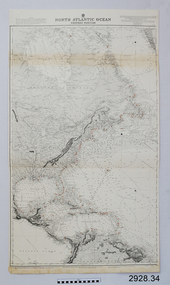 Flagstaff Hill Maritime Museum and Village
Document - Navigation Chart, North Atlantic Ocean, Western Portion
British Admiralty Navigation Chart - North Atlantic Ocean - Western Portionwarrnambool, shipwrecked-coast, flagstaff-hill, flagstaff-hill-maritime-museum, maritime-museum, shipwreck-coast, flagstaff-hill-maritime-village, shipwrecked-artefact, navigation chart, british admiralty navigation chart, british admiralty, north atlantic ocean -
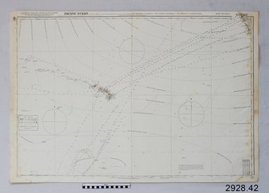 Flagstaff Hill Maritime Museum and Village
Document - Navigation Chart, Pacific Ocean
British Admiralty Navigation Chart - Pacific Ocean, North East Sheetwarrnambool, shipwrecked-coast, flagstaff-hill, flagstaff-hill-maritime-museum, maritime-museum, shipwreck-coast, flagstaff-hill-maritime-village, shipwrecked-artefact, navigation chart, british admiralty navigation chart, british admiralty, pacific ocean