Showing 297 items
matching open spaces
-
 Robin Boyd Foundation
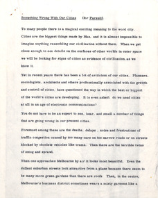
Document - Manuscript, Robin Boyd, Something Wrong with our Cities
... entertainment and culture, with the suburbs having open space... entertainment and culture, with the suburbs having open space ...Makes comparisons between Australian cities and American and European cities. Melbourne and Sydney are heading in the same direction as Los Angeles. A possible future the city containing entertainment and culture, with the suburbs having open space and gardens but with access to city life.Typewritten (c copy), quarto, 3 pagescity, cities, suburbs, melbourne, sydney, american cities, european cities, urban planners, robin boyd, manuscript -
 Whitehorse Historical Society Inc.
Newspaper, Fight Drags On Over Ex-School Site Plans, 28/07/1992 12:00:00 AM
... & Planning Committee of Nunawading Council over siting of 22% Open... of Nunawading Council over siting of 22% Open Public Space on former ...Local Residents make submissions to the Community Services & Planning Committee of Nunawading CouncilLocal Residents make submissions to the Community Services & Planning Committee of Nunawading Council over siting of 22% Open Public Space on former Middlefield Primary School site.Local Residents make submissions to the Community Services & Planning Committee of Nunawading Council middlefield primary school, city of nunawading, primary schools -
 Falls Creek Historical Society
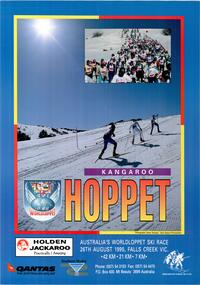
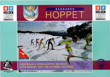
Poster - Kangaroo Hoppet 1995
... Tempest - Open Spaces Photography...: Photographs: Glen Tempest - Open Spaces Photography A large coloured ...The Kangaroo Hoppet is Australia’s premier long distance cross country ski race, and a member of the Worldloppet series of international cross country ski events. The first race at Falls Creek was held in 1979 under the name of “Australian Birkebeiner”. It was a 21km race with about 80 participants organised by the Birkebeiner Nordic Ski Club of Mount Beauty. The course started and finished at Falls Creek Alpine Resort and took participants out into the Bogong High Plains. After running the event for 10 years, it was decided they should become part of the Worldloppet series of marathon ski races. Representatives from the Birkebeiner Nordic Ski Club and the Australian Ski Federation attended the Worldloppet Annual Meeting in Finland in June 1990 to put the case for the acceptance of an Australian event into the Worldloppet series. Before being admitted, they had to demonstrate that the Birkebeiner Club could run a world class event, so three months later in August 1990 a 42km event named the Australian International Ski Marathon was held at Falls Creek together with a 21km Birkebeiner race and a 7km event called the Birkebeiner Lite. The event was approved by delegates from USA, Norway and Austria, in 1991 Australia became the 12th member of Worldloppet, with the condition that there had to be a name change. After some late night discussion allegedly involving red wine from North East Victoria the main event became the 42km Kangaroo Hoppet, with the minor events being the 21km Australian Birkebeiner, and 7km Joey Hoppet. In the winter of 1991, the first Kangaroo Hoppet was held. It was a great success and has been a regular fixture on the international ski calendar ever since. It features the main 42km event as well as a 21km event and a 7km event. The Hoppet brings the Australian snowfields to an international audience. In 1995 the Men's Winner was Andre Jungen from Switzerland in a time of 2:22:57. The winner of the Women's event was Maria Theurl of Austria in a time of 2:56:08.This poster is significant because it documents an event which brings international attention to Falls Creek and the surrounding region.A large coloured poster a main image of skiers ascending a slope. A smaller inset image features a large group of skiers. A title is written at the bottom of the image in graduated orange letters. The logos of Worldloppet, Southern Hydro, Holden, QANTAS and the Birkebeiner Nordic Ski Club are across the bottom.Beneath image: AUSTRALIA'S WORLDLOPPET SKI RACE/ 26TH AUGUST 1995, FALLS CREEK, VIC . 42 KM .21KM. 7KM. Phone: (057) 54 3103 Fax: (057) 54 4475 P.O. Box 400 Mt. Beauty 3699 Australia In Border around photos: Photographs: Glen Tempest - Open Spaces Photographykangaroo hoppet, worldloppet events, falls creek, mt. beauty -
Port Melbourne Historical & Preservation Society
Photograph - Railway Reserve, Sandridge, William Paterson, 1870s
... footbridge just north of Raglan Street; open space is believed... Street; open space is believed to be swamp drainage area between ...One of a series assembled for the Melbourne Exhibition of 1873, original mount hanging in Engineering Department at Port Melbourne Town Hall at 19-9-1994. This set of prints belonged to Town Clerk Syd ANDERSON, then to his daughter-in-law Phyllis ANDERSON (donor). Accompanied by list of captions, both hand written and typed (the latter a partial listing). View from pedestrian bridge over railway, looking southeast over 'ornamental' Railway Reserve, 1870s. Probably taken from footbridge just north of Raglan Street; open space is believed to be swamp drainage area between Raglan and Spring Street. (Location usually attributed to Farrell Street - i.e. taken from footbridge at Bridge and Station, but this proves unlikely as there had been no construction on the swamp between Bridge and Farrell until later.)"P. Anderson" ink, on back:"10" ballpoint, on upper left face of phototransport - railways, built environment, parks and gardens, sydney sims anderson, town clerks, railway reserve, station street -
 Bendigo Historical Society Inc.
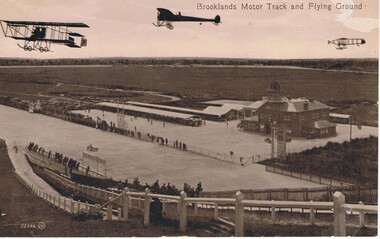
Postcard - BASIL WATSON COLLECTION: BROOKLANDS MOTOR TRACK AND FLYING GROUND
... and in the distance is open space with trees. Spectators line the race track... is open space with trees. Spectators line the race track both ...The postcard shows three planes flying above the Brooklands motor track with 'Brooklands Motor Track and Flying Ground'. To the right is a large two story brick building and on the left of the building is a long open covered vehicle stall. To the back are work sheds, further to the left are spectators cars and in the distance is open space with trees. Spectators line the race track both sides watching a racing car. In the foreground is a hill with fencing down to the track and spectators along the fence.Valentine Seriesaviation, civilian, brooklands motor track -
 Bendigo Historical Society Inc.
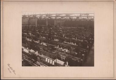
Photograph - HANRO COLLECTION: PHOTOGRAPH OF HANRO KNITTING ROOM
... the machinery with spools of thread in work. The room is a large open... is a large open space with Steel girders at the top with industrial ...See Item 11000.189Photograph of Hanro Knitting Room: On cream card with a silver border with *Bartlett Bros., Bendigo* as the photographers printed in brown ink. The photo is of the knitting rooms showing the machinery with spools of thread in work. The room is a large open space with Steel girders at the top with industrial lighting. The room has numerous knitting machines. The back has tape down the left hand side and hand written in black ink is *Part of Knitting Room* on the top right. Box 116ABartlett Bros., Bendigo.photograph, building, hanro, bartlett bros., bendigo -
 Whitehorse Historical Society Inc.
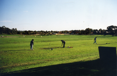
Photograph, Morack Golf Course, C1970
... was rezoned from 'Rural' to 'Public Open Space'. This allowed planning... Course was rezoned from 'Rural' to 'Public Open Space ...In 1970, the area now known as the Morack Golf Course was rezoned from 'Rural' to 'Public Open Space'. This allowed planning to go ahead and by 1973 sufficient land had been acquired by the Melbourne and Metropolitan Board of Works. The course was first open on 8 May 1976 as a nine-hole course. This was extended to 15 holes by January 1980, and to eighteen holes by 1981.Two coloured photographs a-b of the early days in the development of the Morack Golf Course. Overview of a hole plus white patches indicating where trees have been planted. Some people practicing.morack golf course -
 Tarnagulla History Archive
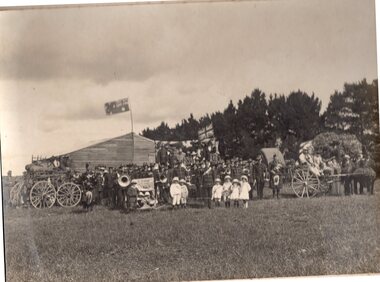
Photograph: Hospital Sunday at Newbridge, Hospital Sunday at Newbridge, 9th November 1913
... , and horse-drawn carriages on an open grassy space, with a line...-drawn carriages on an open grassy space, with a line of tall ...Murray Comrie Collection. Monochrome photograph, image depicting a crowd of people, and horse-drawn carriages on an open grassy space, with a line of tall trees in background. This is a very dark copy of an older original. Copy probably made by Murray Comrie in the 1960s.newbridge, fundraising, community events, picnics, hospital, medicine -
 Greensborough Historical Society
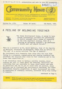
Newsletter, Greenhills and North Greensborough Progress Association, Community News: official journal of the Greenhills and Nth. Greensborough Progress Association and the Apollo Parkways Progress Association. 4th March, 1976. Edition No. 2/76, 04/03/1976
... , Public open space policy, From the Council Chamber, Letter..., Public open space policy, From the Council Chamber, Letter ...This edition includes a report on the The Apollo Parkways Progress Association's February 1976 meeting, A feeling of belonging together. Developers play havoc... with our natural heritage, Meet the natives, This and that, Cameo of Johnny Chester, Public open space policy, From the Council Chamber, Letter to the Editor, School and Kinder news, Diamond Valley Repertory, Eltham Film Society. A digital copy of this Newsletter is available from Greensborough Historical Society.Newsletter, 28 p., illus.greenhills and north greensborough progress association, greenhills, apollo parkways progress association, apollo parkways -
 Lakes Entrance Historical Society
Photograph, M Holding, 1/07/2013 12:00:00 AM
... room area by removing a wall to open the space of original... room area by removing a wall to open the space of original ...showing alterations to the dining room kitchen and sitting room area by removing a wall to open the space of original house built by Sydney and Frances Allen in 1920's Colour photograph of interior of house at 133 Myers St. Lakes Entrance Victoria. Also two photographs showing the alterationshouses, people, architecture -
 Geelong Cycling Club
Pedal Club Records
... and fellowship for all lovers of the open spaces and to develop greater... and fellowship for all lovers of the open spaces and to develop greater ...Pedal Clubs began in the late 1950's to encourage safety, to stimulate interest in getting out into nature, to teach owners how to look after their bikes; to provide to young and old opportunities for healthy recreation; to provide enjoyment and fellowship for all lovers of the open spaces and to develop greater skills in cycling. From the 1970's onwards the clubs developed competitions to encourage safe bike handling and skills. These clubs generally relied on parents to run the competitions for the children in their locations. These clubs provided opportunities for healthy recreation and in addition contributed to social cohesiveness in local communities.Handwritten minutes, reports, correspondence of Geelong West Pedal Club 1986; photographs of club members at club activity days; newspaper articles.geelong west pedal club; sir hubert opperman; 1985; 1986; -
Surrey Hills Historical Society Collection
Postcard - Union Road, Surrey Hills looking north
... be partly seen. In the distance scattered houses and open space can... be partly seen. In the distance scattered houses and open space can ...Surrey Family Hotel (McNeill's Family Hotel) was built in 1888 by Alexander McNeill. It closed as a hotel after the Local Option vote in 1920.A colour post card from a watercolour sketch of the intersection of Union and Canterbury Roads looking north towards Mont Albert Road. It shows bluestone guttering edging the road in the foreground. Children are gathered under the verandah on the SW corner of the intersection and on the road. A horse drawn vehicle is seen travelling to the west down Canterbury Road. McNeill's Family Hotel, the Surrey Hall and part of Hansen's Terrace can be seen. Advertising signs for Otto Preuss (undertaker) and A R B Cuest (baker) can be partly seen. In the distance scattered houses and open space can be seen.Front: Printed on the post card "Union Rd. Surrey Hills, looking North" Rear: "BOX HILL HISTORICAL SOCIETY" (stamp) and "Mrs E W Zerbe / Williamson Rd. / Doncaster" in biro. This is possibly Marjorie Morgan's writing. "POST WTP (within cartouche) CARD" and "Printed / in / Germany" printed on card.mcneill's family hotel, bakers, undertakers, surrey hall, surrey theatre, rex theatre, mr a r b cuest, mr otto preuss -
 Melbourne Tram Museum
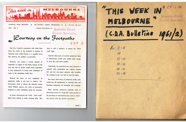
Magazine, City Development Association, "This week in Melbourne", 1961
... , MMBW, open space, population, parking, overseas practices, City..., open space, population, parking, overseas practices, City ...Set of 24 magazines - each a folded foolscap sheet printed on semi gloss paper with a red printed heading, titled "This week in Melbourne", published by the City Development Association - 1961. Looks at issues that affect the Melbourne CBD, traffic, planning, MMBW, open space, population, parking, overseas practices, City of Melbourne, water supply, freight terminal. Published on a fortnightly basis. All contained loosely within a brown card folder with the title written on the front and issue numbers. 1961 issues are: 2-8, 10, 12-15, 18-21, 28-31, 33-36.Has AETA stamp on front cover with the letters "3CT with a running number alongside."trams, tramways, melbourne, city of melbourne, public transport, road transport, traffic control -
 Falls Creek Historical Society
Poster - Kangaroo Hoppet 1994
... Photograph: Glen Tempest/Open Spaces Bottom Left: Logo... 3699 Australia Photograph: Glen Tempest/Open Spaces Bottom ...The Kangaroo Hoppet is Australia’s premier long distance cross country ski race, and a member of the Worldloppet series of international cross country ski events. The first race at Falls Creek was held in 1979 under the name of “Australian Birkebeiner”. It was a 21km race with about 80 participants organised by the Birkebeiner Nordic Ski Club of Mount Beauty. The course started and finished at Falls Creek Alpine Resort and took participants out into the Bogong High Plains. After running the event for 10 years, it was decided they should become part of the Worldloppet series of marathon ski races. Representatives from the Birkebeiner Nordic Ski Club and the Australian Ski Federation attended the Worldloppet Annual Meeting in Finland in June 1990 to put the case for the acceptance of an Australian event into the Worldloppet series. Before being admitted, they had to demonstrate that the Birkebeiner Club could run a world class event, so three months later in August 1990 a 42km event named the Australian International Ski Marathon was held at Falls Creek together with a 21km Birkebeiner race and a 7km event called the Birkebeiner Lite. The event was approved by delegates from USA, Norway and Austria, in 1991 Australia became the 12th member of Worldloppet, with the condition that there had to be a name change. After some late night discussion allegedly involving red wine from North East Victoria the main event became the 42km Kangaroo Hoppet, with the minor events being the 21km Australian Birkebeiner, and 7km Joey Hoppet. In the winter of 1991, the first Kangaroo Hoppet was held. It was a great success and has been a regular fixture on the international ski calendar ever since. It features the main 42km event as well as a 21km event and a 7km event. The Hoppet brings the Australian snowfields to an international audience. In 1994 the Men's Winner was Peter Schlickenreider from Germany in a time of 1:41:02. The winner of the Women's event was Antonina Ordina of Sweden in a time of 1:53:19.This poster is significant because it documents an event which brings international attention to Falls Creek and the surrounding region.A large coloured poster featuring a central image of competitors in the Kangaroo Hoppet with dates and logos.At top: Logo for Holden Light Commercials on either side of text KANGAROO HOPPET and WorldLoppet Logo Across bottom of image: AUSTRALIA'S WORLDLOPPET SKI RACE/ 27th AUGUST 1994, FALLS CREEK VICTORIA Race Secretary / Phone: (057) 57 3103 / Fax (057) 57 2475 / P.O. BOX 400 Mt. Beauty 3699 Australia Photograph: Glen Tempest/Open Spaces Bottom Left: Logo of the BERKENBEINER NORDIC SKI CLUB Bottom Right: Kangaroo Hoppet Logokangaroo hoppet, worldloppet events, falls creek, mt. beauty -
 Eltham District Historical Society Inc
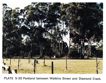
Work on paper (Sub-Item) - Photograph, Parkland between Watkins Street and Diamond Creek, 1976
... and Diamond Creek identifed as Watkins Street Reserve. Open green... and Diamond Creek identifed as Watkins Street Reserve. Open green ...Colour photograph of Parkland between Watkins Street and Diamond Creek identifed as Watkins Street Reserve. Open green space surrounded by eucalyptus trees. Young plants are staked in the foreground of the imagediamond creek, watkins street reserve, parkland, park -
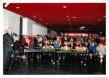
 Melbourne Legacy
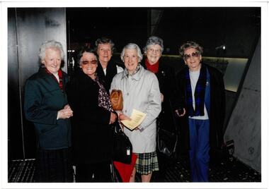
Photograph, Pilgrimage to the Shrine 2003, 2003
... of Remembrance as well as open space for exhibitions and events... of Remembrance as well as open space for exhibitions and events ...Wreath laying ceremony for Legacy widows at the Cenotaph at the Shrine of Remembrance. This is an annual event for Legacy widows at the start of Legacy Week, which is the first week in September. The photos shows the widows after a service in the Visitor Centre of the Shrine of Remembrance. From the film numbers it appears to be 2003 when David Ford was president (see also 00615). The Visitor Centre was completed in 2003 and provides unimpeded access for the elderly and disabled to the Sanctuary, the Crypt and the Galleries of Remembrance as well as open space for exhibitions and events. The event is known as Widows' Sunday, Legacy Sunday and pilgrimage to the Shrine.A record of a ceremony at the Shrine in 2003.Colour photo x 2 of six widows at the Shrine visitor centre.Printed on the back No.< > Clarendon Photos 0014 which is the frame numbers and place of processing. Negative numbers 7 and 8.widows, widows' sunday, pilgrimage, wreath laying ceremony -
 Ringwood and District Historical Society
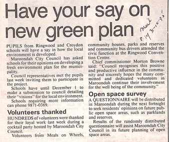
Newspaper, Scrapbook Clipping, Library Collection, Ringwood, Victoria, `
... to seek residents' opinions on future public open space areas... open space areas, such as parklands and reserves. Newspaper ...``Newspaper clipping from The "Mail" , 31-10-95 P19 .Have your say on new green plan.Pupils from Ringwood and Croydon schools will have a say in how the local environment is developed.Maroondah City Council has asked schools for their opinions on developing a fresh environment plan for the municipality. -- Hundreds of volunteers were thanked for their loyal work last week during a cocktail party hosted by Martoondah City Council. Chief Commissioner Morton Browne thanked the "many committed and dedicated volunteers". A questionnaire will be distributed in Maroondah during the next fortnight to seek residents' opinions on future public open space areas, such as parklands and reserves.` -
 Linton and District Historical Society Inc
Photograph, Unidentified Event
... . Photograph shows group of people gathered on a grassy area/open space.... Photograph shows group of people gathered on a grassy area/open space ...Photograph of unidentified event, late 19th/early 20th century, possibly a gathering of the Linton Caledonian Society. Photograph shows group of people gathered on a grassy area/open space in front of a wooden building, trees in background. Some of the group are wearing uniforms and appear to be members of a brass and/or highland band. To the left is a wagon/cart with baggage and chairs(?) loaded on it. To the right is a horse-drawn cart with people seated on it, other people standing just behind it. About ten small children are in a row at the front of the group. A sign just behind them reads "A Chip Off the Old Block". Two flags are flying, one an Australian flag, the other a Union Jack. -
 Truganina Explosives Reserve Preservation Society Inc (TERPS)
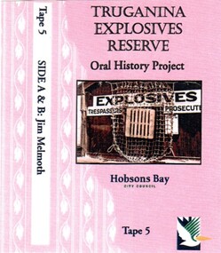
Digitised Oral History – Truganina Explosives Reserve - Tape 9 Andrew Shannon and Judy Hindle, 2018
... council. Their motivation was to not only save the site for open... was to not only save the site for open space but to capture what Judy ...The interviews were recorded in 2000 by Bronwen Gray and Alan Young for the production of Unreserved, Stories from Truganina Explosives Reserve, animated stories from past residents, workers and interested people of the Reserve (subject to copyright 2004). Judy Hindle and Andrew Shannon worked jointly on saving the Truganina Explosives Reserve from being sold for development by the State Government. Judy was an Altona resident and Andrew was an environment planner, first with Parks Victoria and then the local council. Their motivation was to not only save the site for open space but to capture what Judy described as the only in-tact historical site in the area. A primary source of information on memories of the Truganina Explosives Reserve and Altona,VictoriaDigital copy of original cassette recorded in 2000 and digitised in 2018chirnside, explosives, tin fence, coastal vegetation, parks victoria, joan kirner, cheetham wetlands, doug grant, gahnia, salt marsh, sand ridges, rob andrew, nessie hardy, aboriginal middens, altona, truganina swamp -
 Melbourne Legacy
Photograph, Pilgrimage to the Shrine 2003, 2003
... of Remembrance as well as open space for exhibitions and events.... of Remembrance as well as open space for exhibitions and events. A record ...Wreath laying ceremony for Legacy widows at the Cenotaph at the Shrine of Remembrance. This is an annual event for Legacy widows at the start of Legacy Week, which is the first week in September. The photos shows the widows gathered for a service within the Shrine of Remembrance with wreaths ready to be laid. Legatee David Kelly appears to be speaking in one photo. From the film numbers it appears to be 2003 when David Ford was president (see also 00615). The service appears to be in The Visitor Centre which was completed in 2003. The Visitor Centre provides unimpeded access for the elderly and disabled to the Sanctuary, the Crypt and the Galleries of Remembrance as well as open space for exhibitions and events.A record of a ceremony at the Shrine in 2003.Colour photo x 2 of a service in the Shrine visitor centre.Printed on the back No.< > Clarendon Photos 0013 which is the frame numbers and place of processing. Negative numbers 16A and 17A.widows, widows' sunday, pilgrimage, wreath laying ceremony -
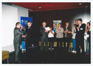 Melbourne Legacy
Photograph - Legacy Week 2004, Event at the Shrine, 2004
... as open space for exhibitions and events...., the Crypt and the Galleries of Remembrance as well as open space ...An event at the Shrine of Remembrance Visitor Centre, the guests include some youths and Ron Barassi and President George MacKenzie. It could be the launch of Badge week - the poster says: Buy a Badge, with an image of the Widow and Children statue. See also 00686. Ron Barassi, an ex-AFL footballer, participated in several Legacy events over the years. Ron was a a junior legatee after his father Ron Snr was killed in action at Tobruk in World War II, aged 27. The Visitor Centre was completed in 2003 and provides unimpeded access for the elderly and disabled to the Sanctuary, the Crypt and the Galleries of Remembrance as well as open space for exhibitions and events.A record of an event at the Shrine for Legacy Week in 2004.Colour photo x 2 of an event at the Visitor Centre at the Shrine with guest Ron Barassi. Printed on the back "No.< > Clarendon Photos 0556" which is the frame numbers and place of processing. Negative numbers 5 and 2.legacy week, legacy appeal -
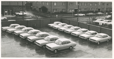 Royal District Nursing Service (now known as Bolton Clarke)
Photograph - Photograph, black and white, Barry Sutton, 26.06.1972
... area of the rear brick wall in the open space between the two... to the lower area of the rear brick wall in the open space between ...This photograph is a good view of the car park at RDNS Headquarters, 452 St. Kilda Road, Melbourne, with the new Torana two door vehicles. The RDNS insignia seen on some of the cars is a thin royal blue circle with the words "Royal District Nursing Service" written in white capital letters. The centre section is in three with the top and bottom section white and the centre section royal blue with the large capital white letters "RDNS" written across it.Royal District Nursing Service (RDNS) has had various modes of transport over the last 130 plus years. At first, from 1885 as Melbourne District Nursing Society (MDNS), their Trained nurses (Nurses) walked the streets and lane ways amid the slums of central Melbourne. As the Society expanded public transport was used, and bicycles were bought by the Society in 1903 and used in inner areas until 1945. During the Spanish flu epidemic, in 1919, MDNS appealed for assistance to procure Motor vehicles so the Nurses could visit an influx of cases. Through trusts, grants and donations four 'Ford T Model' cars were procured which enabled the Nurses to triple their visits. Through constant use the cars were in such a poor state two were sold in 1922 and the others later. In 1922-23 three Peugeot cars were purchased and a woman Chauffeur, 'Miss Sword', was employed who lived in the Home and was also in charge of the garage. MDNS was expanding and a Motor Auxiliary was formed in 1929 to take the Trained nurses (Sisters) to patients, and some Sisters used their own cars; even a motorcycle was used by one Sister in 1933. All these forms of transport were intermingled and in the early 1950s, and now as Melbourne District Nursing Service, seven Ford Prefect cars were bought followed by twelve Ford Anglia cars 1955. Having received Royal patronage; the now Royal District Nursing Service (RDNS) had its own fleet of Holden vehicles by the mid 1960s and the Motor Auxiliary ceased operating in 1971 as by then all staff employed were required to have a driving licence. Seat-belts had been introduced to Victoria in 1959 and District fitted them to their cars from 1962, even though they did not become compulsory until 1970. The Holden vehicles were replaced with grey Holden Torana vehicles. After several years the fleet was changed to white Toyota Corolla vehicles. The Melways Directory of maps was introduced in 1966, which was a boon to the Sisters, though it was a few years before it went beyond Seville, so a large paper map was used by the Sisters visiting patients in the areas passed Seville. By 2009 there were 598 cars in the fleet and the Sisters travelled 9 million 200,000 kilometres – this is equivalent to 12 trips to the moon and back. Black and white photograph taken above, and giving a "birds eye view", of the car park and latest fleet of grey Holden Torana two door vehicles owned by Royal District Nursing Service (RDNS). The fourteen cars are parked in two rows with the front of the cars facing to the left of the photograph. The round RDNS insignia is seen in the upper centre of some car doors. A tall brick wall is seen along the rear and right hand side of the car park. Two fire extinguishers are seen attached to the lower area of the rear brick wall in the open space between the two rows of cars. In the background and to the left, a road, some cars and parts of two brick buildings are seen as well as several small bare trees.Barry Sutton's Photographers Stamp. Quote KX 86royal district nursing service, rdns, rdns transport, rdns headquarters, rdns carpark, -
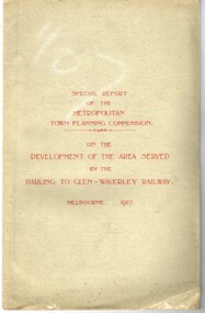 Melbourne Tram Museum
Document - Report, Metropolitan Town Planning Commission, "Metropolitan Town Planning Commission - Darling to Glen Waverley Railway - 1927", May. 1927
... type layouts, rail level crossings, new arterial roads, open... type layouts, rail level crossings, new arterial roads, open ...Report - 20 pages + 5 Maps stapled and then glued bound within a light green grey light card folder titled "Metropolitan Town Planning Commission - Special Report on the Development of the area serviced by the Darling to Glen Waverley Railway - 1927". Report looks the development that could be undertaken along the proposed Glen Waverley rail line, its town planning, Garden City type layouts, rail level crossings, new arterial roads, open spaces, financial arrangements, sewerage and water supply, zoning, legislation and conclusion. Dated 6/5/1927. Plans show possible garden city type layouts, arterial roads, possibilities within existing sub-divisions. Note that Mr. Strickland was a member of the Commission undertaking this work.Has in ink on the bottom edge "17th June 1919"trams, tramways, mmtb, tramways, development, town planning, glen waverley, darling -
 Melbourne Legacy
Photograph - Legacy Week 2004, Event at the Shrine, 2004
... of Remembrance as well as open space for exhibitions and events... of Remembrance as well as open space for exhibitions and events ...An event at the Shrine of Remembrance Visitor Centre, the guests include some youths and Ron Barassi. Afterwards they posed for a photo in the Garden Courtyard. The president is George McKenzie. Ron Barassi participated in several Legacy events over the years. Ron was a a junior legatee after his father Ron Snr was killed in action at Tobruk in World War II, aged 27. From the film numbers see also 00686 and 00687. The Visitor Centre was completed in 2003 and provides unimpeded access for the elderly and disabled to the Sanctuary, the Crypt and the Galleries of Remembrance as well as open space for exhibitions and events. The courtyard has an olive tree as a centrepiece. This is the olive tree of peace that was planted by Legacy in 1973 to mark their golden jubilee. It was relocated to the new courtyard in 2002 when the Shrine was being redeveloped.A record of a ceremony at the Shrine for Legacy Week in 2004.Colour photo of the Legacy President George McKenzie with Ron Barassi and other dignitaries.Printed on the back "No.<10> Clarendon Photos 0556" which is the frame numbers and place of processing.legacy week, legacy promotion, george mckenzie -
 City of Kingston
Photograph - Black and white, c.1973
... is shelved with books. There is a large amount of open floor space... is shelved with books. There is a large amount of open floor space ...This photograph shows a library interior with three women in the back corner. Black and white photograph of the interior of a library. There are empty shelves along the left hand wall with boxes on the floor in front of them. Three women are standing in the back corner, two facing away from the camera and one looking towards it. An open door shows a refrigerator in another room. The back wall is shelved with books. There is a large amount of open floor space in the foregroundPrinted in grey ink: | 526B / 15.11.78library, libraries -
 Eltham District Historical Society Inc
Journal - Newsletter, Nillumbik Shire Council, Nillumbik News, October 2000
... Environment Centre proposed for Edendale Farm Open Space Strategy... Environment Centre proposed for Edendale Farm Open Space Strategy ...October 2000 articles include: Safer roads for the Shire Eltham Festival program announced Commercial Place design released 2000-2003 Council Plan Released National Reconciliation Framework Living and Learning Centres More Playgrounds Susan St Pavilion completed Study to plan for BMX/skate track Wattle Glen Township Strategy Community Weed Control Program Count Koala Day Environment Centre proposed for Edendale Farm Open Space Strategy findings Neighbourhood Character Study and Residential Design Guidelines Friends groups Clean Drains – Living Creeks, National Water Week Nillumbik Shire Council Cultural Plan 2000-2005 adopted 2001 Alan Marshall Short Story Award Artists’ Open Studios program Kangaroo Ground Tower Advisory Committee Environment leaders at Eltham North primary Dollars saved by regular road maintenance Regional Road upgrades Rural roads grading program Stormwater Management Plan Locality boundary update council newsletters, nillumbik news, nillumbik shire council -
 Kew Historical Society Inc
Photograph - Civic event in Stradbroke Park, 1976
... as 'open space' and named 'Stradbroke Park'. The line of the creek... and a reserve created; 1954 - Entire area designated as 'open space ...Stradbroke Park. Extent: Kilby Road to Harp Road at Burke Road. Historical Documentation: 1851 - Portion 91 purchased by Edward Glynn; 1888 - The Harp of Erin Estate (which included Section 91) offered for sale; 1896 - The area now known as Stradbroke Park was bisected by a creek that flowed from the Yarra via Hay's Paddock (q.v.) and extended through to Burke Road; 1943 - W.D. Birrell, Town Clerk of Kew, proposed that the creek be filled and a reserve created; 1954 - Entire area designated as 'open space' and named 'Stradbroke Park'. The line of the creek that ran through the Park created a further reserve on the north side of High Street, now known as 'Harrison Reserve'. Existing Condition: The park is largely of mown grass that has mature trees set into it It is possible that a number of these are remnant of the original vegetation, while there are also a number of exotic trees introduced, particularly at the northern end of the park. The southern end is dominated by playing fields. (Source: Sanderson, P 1988. Kew Conservation Study)Colour photographic positive (with colour degradation) of sporting teams at a civic event in Stradbroke Park in Kew East in May 1976. The event was officiated by the Mayor of Kew, Cr Alan Hutchinson. Sporting teams in uniform included: footballers, athletes, cricketers, hockey players. Stradbroke Park is situated on the western boundary of Kew at Burke and Harp Roads.stradbroke park, cr alan hutchinson, team sports -- kew (vic.) -
 Kew Historical Society Inc
Photograph - Civic event in Stradbroke Park, 1976
... as 'open space' and named 'Stradbroke Park'. The line of the creek... and a reserve created; 1954 - Entire area designated as 'open space ...Stradbroke Park. Extent: Kilby Road to Harp Road at Burke Road. Historical Documentation: 1851 - Portion 91 purchased by Edward Glynn; 1888 - The Harp of Erin Estate (which included Section 91) offered for sale; 1896 - The area now known as Stradbroke Park was bisected by a creek that flowed from the Yarra via Hay's Paddock (q.v.) and extended through to Burke Road; 1943 - W.D. Birrell, Town Clerk of Kew, proposed that the creek be filled and a reserve created; 1954 - Entire area designated as 'open space' and named 'Stradbroke Park'. The line of the creek that ran through the Park created a further reserve on the north side of High Street, now known as 'Harrison Reserve'. Existing Condition: The park is largely of mown grass that has mature trees set into it It is possible that a number of these are remnant of the original vegetation, while there are also a number of exotic trees introduced, particularly at the northern end of the park. The southern end is dominated by playing fields. (Source: Sanderson, P 1988. Kew Conservation Study)Colour photographic positive (with colour degradation) of sporting teams at a civic event in Stradbroke Park in Kew East in May 1976. The event was officiated by the Mayor of Kew, Cr Alan Hutchinson. Stradbroke Park is situated on the western boundary of Kew and bordered by Burke and Harp Roads.stradbroke park, cr alan hutchinson, team sports -- kew (vic.) -
 Melbourne Legacy
Photograph, Legacy Appeal 2003 at the Shrine, 2003
... as open space for exhibitions and events.... as open space for exhibitions and events. A record of a function ...An event at the Shrine of Remembrance Visitor Centre, the guest speaker appears to be a school girl and present is a Edward (Ted) Kenna a VC winner. It could be the launch of Badge week - the poster says: Support Legacy Buy a Badge with a boy playing at the beach. 685.1 The President David Ford with the school girl 685.2 Four men, second from left is Ray Ward with Chairman on his badge, on the right is a representative from the Department of Veterans Affairs. 685.3 A group including the Ted Kenna VC and his wife Marjorie. 6865.4 Bill Panter, Edward Kenna VC and Legatee Stan Carpenter (this photo was featured in the President's report published with the 80th Annual Report). 685.5 David Cull and Marjorie Kenna. 685.6 The school girl speaking 685.7 President David Ford and Ted Kenna VC The Visitor Centre was completed in 2003 and provides unimpeded access for the elderly and disabled to the Sanctuary, the Crypt and the Galleries of Remembrance as well as open space for exhibitions and events.A record of a function at the Shrine for Legacy Week 2004.Colour photo x 7 of the launch of Legacy Week in 2003 at the Shrine with school girl speaking and Edward Kenna VC as a guest.Printed on the back No.< > Clarendon Photos 0013 which is the frame numbers and place of processing. Negative numbers 3A, 6A, 8A, 10A, 11A, 14A and 15A.legacy week, legacy appeal