Showing 155 items
matching parish of nillumbik
-
 Greensborough Historical Society
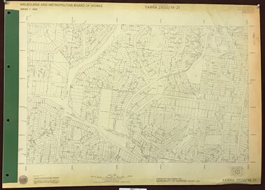
Map, Melbourne and Metropolitan Board of Works. Survey Division, MMBW, Yarra 2500 / 14.21. St Helena, Weidlich Road, 1979_08
... map] 14.21. St Helena, Weidlich Road. Parish of Nillumbik 3310.... Parish of Nillumbik 3310. Municipality of Diamond Valley 257 ...Melbourne and Metropolitan Board of Works. Yarra 2500 [base map] 14.21. St Helena, Weidlich Road. Parish of Nillumbik 3310. Municipality of Diamond Valley 257. Prominent streets St Helena Road, Weidlich Road, Karingal Drive and Progress Road. Features include the Blair Reserve.MMBW Map in 1:2500 [scale] series. Cream parchment with green tape reinforcing on edges and punched holes on left edge.mmbw, melbourne and metropolitan board of works, shire of diamond valley, st helena - maps -
 Greensborough Historical Society
Map, Melbourne and Metropolitan Board of Works. Survey Division, MMBW, Yarra 2500 / 16.23. Diamond Creek, 1978_02
... map] 16-23. Diamond Creek. Parish of Nillumbik 3310... of Works. Yarra 2500 [base map] 16-23. Diamond Creek. Parish ...Melbourne and Metropolitan Board of Works. Yarra 2500 [base map] 16-23. Diamond Creek. Parish of Nillumbik 3310. Municipalities of Diamond Valley 257 and Eltham 238. Prominent streets include: Phipps Crescent, Bishop Avenue, and Reynolds Road. Includes the former Diamond Creek Technical School.MMBW Map in 1:2500 [scale] series. Cream parchment with green tape reinforcing on edges and punched holes on left edge.mmbw, melbourne and metropolitan board of works, shire of diamond valley, diamond creek - maps -
 Greensborough Historical Society
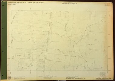
Map, Melbourne and Metropolitan Board of Works. Survey Division, MMBW, Yarra 2500 / 14.24. Plenty, 1979_05
... map] 14.24. Plenty. Parishes of Nillumbik 3310 and Morang 3183... of Works. Yarra 2500 [base map] 14.24. Plenty. Parishes ...Melbourne and Metropolitan Board of Works. Yarra 2500 [base map] 14.24. Plenty. Parishes of Nillumbik 3310 and Morang 3183. Municipality of Diamond Valley 257. Prominent streets include: Heard Road, Hillmartin Road and Yan Yean Road. Features include Plenty Primary School and Plenty Park.MMBW Map in 1:2500 [scale] series. Cream parchment with green tape reinforcing on edges and punched holes on left edge.mmbw, melbourne and metropolitan board of works, shire of diamond valley, plenty - maps -
 Greensborough Historical Society
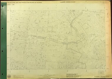
Map, Melbourne and Metropolitan Board of Works. Survey Division, MMBW, Yarra 2500 / 13.20. Greensborough, Montmorency and Watsonia, 1979_03
... map] 13-20. Greensborough, Montmorency and Watsonia. Parishes... and Watsonia. Parishes of Nillumbik 3310 and Keelbundora 2856 ...Melbourne and Metropolitan Board of Works. Yarra 2500 [base map] 13-20. Greensborough, Montmorency and Watsonia. Parishes of Nillumbik 3310 and Keelbundora 2856. Municipalities of Eltham 238 and Diamond Valley 257. Prominent streets include: Nell Street, Nepean Street and Alexandra Street. Includes Montmorency High School.MMBW Map in 1:2500 [scale] series. Cream parchment with green tape reinforcing on edges and punched holes on left edge.mmbw, melbourne and metropolitan board of works, shire of diamond valley, greensborough - maps, montmorency - maps, watsonia - maps -
 Greensborough Historical Society
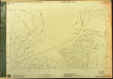
Map, Melbourne and Metropolitan Board of Works. Survey Division, MMBW, Yarra 2500 / 16.24. Northern Diamond Creek and Wattle Glen, 1978_02
... map] 16-24. Northern Diamond Creek and Wattle Glen. Parishes... and Wattle Glen. Parishes of Nillumbik 3310 and Greensborough 2724 ...Melbourne and Metropolitan Board of Works. Yarra 2500 [base map] 16-24. Northern Diamond Creek and Wattle Glen. Parishes of Nillumbik 3310 and Greensborough 2724. Municipalities of Diamond Valley 257 and Eltham 238. Prominent streets include: Hurstbridge Road, and Reynolds Road. Includes Wattle Glen Station.MMBW Map in 1:2500 [scale] series. Cream parchment with green tape reinforcing on edges and punched holes on left edge.mmbw, melbourne and metropolitan board of works, shire of diamond valley, wattle glen - maps, diamond creek - maps -
 Greensborough Historical Society
Map, Melbourne and Metropolitan Board of Works. Survey Division, MMBW, Yarra 2500 / 15.21. Eltham North, 1979_08
... map] 15.21. Eltham North. Parish of Nillumbik 3310... of Works. Yarra 2500 [base map] 15.21. Eltham North. Parish ...Melbourne and Metropolitan Board of Works. Yarra 2500 [base map] 15.21. Eltham North. Parish of Nillumbik 3310. Municipalities of Diamond Valley 257 and Eltham 238. Prominent streets include: Progress Road, Glen Park Road and Zig Zag Road. Features include the Diamond Creek, Eltham Council Pound and Eltham North Reserve.MMBW Map in 1:2500 [scale] series. Cream parchment with green tape reinforcing on edges and punched holes on left edge.mmbw, melbourne and metropolitan board of works, shire of diamond valley, nillumbik, eltham - maps -
 Greensborough Historical Society
Map, Melbourne and Metropolitan Board of Works. Survey Division, MMBW, Yarra 2500 / 15.24. Diamond Creek, Grassy Flat Road, 1978_02
... map] 15.24. Diamond Creek, Grassy Flat Road. Parish... Road. Parish of Nillumbik 3310. Municipality of Diamond Valley ...Melbourne and Metropolitan Board of Works. Yarra 2500 [base map] 15.24. Diamond Creek, Grassy Flat Road. Parish of Nillumbik 3310. Municipality of Diamond Valley 257. Prominent streets include: Everleigh Drive, Broad Gully Road and Clyde Street. Features include the Diamond Creek, Nillumbik Park and Diamond Creek Reservoir.MMBW Map in 1:2500 [scale] series. Cream parchment with green tape reinforcing on edges and punched holes on left edge.mmbw, melbourne and metropolitan board of works, diamond creek - maps, shire of diamond valley -
 Greensborough Historical Society
Map, Melbourne and Metropolitan Board of Works. Survey Division, MMBW, Yarra 2500 / 14.22. St Helena, St Katherine's Church, 1979_08
... map] 14.22. St Helena, St Katherine's Church. Parish... Church. Parish of Nillumbik 3310. Municipality of Diamond Valley ...Melbourne and Metropolitan Board of Works. Yarra 2500 [base map] 14.22. St Helena, St Katherine's Church. Parish of Nillumbik 3310. Municipality of Diamond Valley 257. Prominent streets St Helena Road, Weidlich Road, Yan Yean Road and Allumba Drive. Features include St Katherine's Church of England and the St Helena Secondary College site.MMBW Map in 1:2500 [scale] series. Cream parchment with green tape reinforcing on edges and punched holes on left edge.mmbw, melbourne and metropolitan board of works, shire of diamond valley, st helena - maps, st katherines church st helena -
 Greensborough Historical Society
Map, Melbourne and Metropolitan Board of Works. Survey Division, MMBW, Yarra 2500 / 13.22. Greensborough, Apollo Parkways, 1979_06
... map] 13-22. Greensborough, Apollo Parkways. Parishes... Parkways. Parishes of Nillumbik 3310 and Keelbundora 2856 ...Melbourne and Metropolitan Board of Works. Yarra 2500 [base map] 13-22. Greensborough, Apollo Parkways. Parishes of Nillumbik 3310 and Keelbundora 2856. Municipalities of Diamond Valley 257 and Whittlesea 239. Prominent streets include: Plenty River Drive, Diamond Creek Road and Civic Drive. Includes Diamond Valley Civi Centre, Churinga, Janefield Colony Reserve and "proposed freeway" now Greensborough Highway (Bypass)MMBW Map in 1:2500 [scale] series. Cream parchment with green tape reinforcing on edges and punched holes on left edge.mmbw, melbourne and metropolitan board of works, shire of diamond valley, greensborough - maps, apollo parkways - maps -
 Eltham District Historical Society Inc
Document - Survey Plan, Country Roads Board et al, SP 12272A, Eltham-Yarra Glen Road; Brougham St to Dalton St, 1970-1976
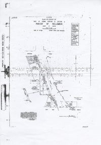
... Section 4 Parish of Nillumbik, County of Evelyn Eltham-Yarra Glen... Section 4 Parish of Nillumbik, County of Evelyn Eltham-Yarra Glen ...1970 C.R.B. Plan of Survey of Part of Crown Portion 12 Section 4 Parish of Nillumbik, County of Evelyn Eltham-Yarra Glen Road, Shire of Eltham Shows Surveyor field notes, property ownership and building type and construction. John L. Roberts, Licensed Surveyor as noted 4 June 1970 Amendments in black by John L. Roberts, L.S. 20-12-76 See also EDHS_05783 (1958)eltham-yarra glen road, 1970, 1976, a.f. munday, brougham street, dalton street, eltham, eltham clinic, g.t. & e.a. donnelly, jarrold cottage, l.m. jarrold, m.s.m. skipper, main road eltham, map, maria street, matcham skipper, mobil service centre (eltham), mobil service station, napoleon street, survey plan, white cloud cottage, country roads board -
 Greensborough Historical Society
Poster - Planning Document, City of Heidelberg, Subdivision Plan # G 27, Greensborough and Diamond Creek, 1922 and 1963
... Parish of Nillumbik, Portion 13: Plan 1: Diamond Creek Road... Parish of Nillumbik, Portion 13: Plan 1: Diamond Creek Road ...Plan of Subdivisions in City of Heidelberg: Side 1: 2 plans, Parish of Keelbundoora: plan 1: Henry Street, Vermont Avenue, Lyell Street, Nell Street, McDowell Street, 1922. Plan 2: Henry Street, Nepean Street, Charles Street, 1922. Side 2: 2 plans Parish of Nillumbik, Portion 13: Plan 1: Diamond Creek Road, Delfin Crescent, Ridge Road, 1963. Plan 2: Kinglake Road, Eltham Road, 1963.An example of hard copy subdivision plans from the Greensborough area. Mainly from the Shire of Diamond Valley era (1964-1994).Plan (2 sided) mounted on heavy card. Contains 2 sheets pasted together.Stamped and handwritten Council permissions, dates and other details.subdivision plans, city of heidelberg -
 Greensborough Historical Society
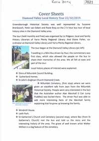
Booklet and article, Diamond Valley Local History Tour 2019, by Yarra Plenty Regional Library, 22/10/2019
... , there are leaflets on Anglican parish of Diamond Creek; Nillumbik Cemetery... visited, there are leaflets on Anglican parish of Diamond Creek ...Cover article written by Rosie Bray. In addition to YPRL booklets which have a brief history of each site visited, there are leaflets on Anglican parish of Diamond Creek; Nillumbik Cemetery; Ellis Cottage; Greensborough Cemetery and Sutherland Homes for ChildrenBooklet (2 copies) containing a brief history of sites visited on the Library's Diamond Valley Tour 2019, with 21 p. of supplementary information by various writers and 6 photographs taken on the tour.diamond valley, yarra plenty regional library, sutherland homes, st katherines church st helena, andrew yandell reserve, greensborough rsl, greensborough war memorial park, greensborough cemetery -
 Eltham District Historical Society Inc
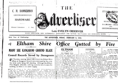
Folder, Eltham Shire Office Fire, 1934
... : "Kangaroo Ground, Parish of Nillumbik, Country of Evelyn, land...: "Kangaroo Ground, Parish of Nillumbik, Country of Evelyn, land ...Anecdotes about caretaker, Mr W. Carroll (Tiny), an old identity by H. Gillam, 1p History of records in office Fire, 1934 by Frank McMahon, 4p. Advertiser article 9/2/1934, Eltham Shire Office gutted by fire, 2p Advertiser article 16/2/1934, Eltham Shire Office post fire and early history as Evelyn Observer office, 2p Advertiser article 23/2/1934, Praise for Eltham Fire Brigade by Shire Secretary P.J.McMahon, 1p Extracts from "The Grass is Green" by Alan Marshall referencing Tiny Carroll, pp28-67 Recollections of Jocelyn McMahon (nee Shallard) on Office staff and conditions, 1928 to 1935,1p. Folder no 62 Photocopies of various newspaper articles from "The Advertiser", 1934 included in attached list. Typed transcription from "Diamond Valley News", 10 October, 1961 Includes copy of hand drawn map: "Kangaroo Ground, Parish of Nillumbik, Country of Evelyn, land holdings 1860s-1900s" with site of Eltham Shire Offices marked.Folder of photocopies, a transciption and typed up memoriesHG Booklets 8 and 62fire, reminiscences, tiny carroll, jocelyn mcmahon (nee shallard), harry gilham collection, eltham shire office, frank mcmahon, kangaroo ground, map, bill o'laughlin, cr jim ryan, evelyn observer, p.j. mcmahon, pelling, woodlands homestead -
 Eltham District Historical Society Inc
Photograph, Liz Pidgeon, Heritage Excursion; East of Eltham, 6 Sep 2014, 20 May 2017
... , there was a brief history of Crown Allotment 15 Section 5 Parish..., there was a brief history of Crown Allotment 15 Section 5 Parish ...Newsletter No. 218, September 2014 September Excursion - East of Eltham Walk In Newsletter No. 197, March 2011, there was a brief history of Crown Allotment 15 Section 5 Parish of Nillumbik (CA 15) a parcel of land of a quarter of a square mile extending from Eucalyptus Road to Reynolds Road at the eastern extremity of Eltham. From the 1940s it was known as Stokes orchard. In later years it has been subdivided for residential purposes but leaving significant areas as power line and water supply reserves and bushland reserves that are habitat for the threatened For our excursion on 6th September we intend to walk through CA 15 to a bushland reserve east of Reynolds Road. The walk will traverse the boundary between suburban Eltham and the non-urban areas to the south and east. This is a pleasant walk through residential areas and bushland. Along the way we will discuss the early and more recent history of CA 15 as well as local natural history and geology. This walk is about 3.5 km in length and will take 2 to 2.5 hours. It will start at 2pm at the corner of Eucalyptus Road, Pitt Street and Nyora Road.Born Digitaleltham east, eltham district historical society, heritage excursion, activities, nyora road, reynolds road, gum tree road reserve, diosma road, stokes orchard, eucalyptus road -
 Eltham District Historical Society Inc
Photograph, Liz Pidgeon, Heritage Excursion; East of Eltham, 6 Sep 2014, 20 May 2017
... , there was a brief history of Crown Allotment 15 Section 5 Parish..., there was a brief history of Crown Allotment 15 Section 5 Parish ...Newsletter No. 218, September 2014 September Excursion - East of Eltham Walk In Newsletter No. 197, March 2011, there was a brief history of Crown Allotment 15 Section 5 Parish of Nillumbik (CA 15) a parcel of land of a quarter of a square mile extending from Eucalyptus Road to Reynolds Road at the eastern extremity of Eltham. From the 1940s it was known as Stokes orchard. In later years it has been subdivided for residential purposes but leaving significant areas as power line and water supply reserves and bushland reserves that are habitat for the threatened For our excursion on 6th September we intend to walk through CA 15 to a bushland reserve east of Reynolds Road. The walk will traverse the boundary between suburban Eltham and the non-urban areas to the south and east. This is a pleasant walk through residential areas and bushland. Along the way we will discuss the early and more recent history of CA 15 as well as local natural history and geology. This walk is about 3.5 km in length and will take 2 to 2.5 hours. It will start at 2pm at the corner of Eucalyptus Road, Pitt Street and Nyora Road.Born Digitaleltham east, eltham district historical society, heritage excursion, activities, nyora road, reynolds road, gum tree road reserve, diosma road, stokes orchard, eucalyptus road