Showing 22454 items matching "parks"
-
 Tatura Irrigation & Wartime Camps Museum
Booklet, The Streets and Parks of Mooroopna, 1999
... The Streets and Parks of Mooroopna ...Produced to ensure accurate recording of information re town of Mooroopna. Maps and street names and parkland included. Dedicated to the memory of the Late Jean Anselmi (1916-1998)Green card cover with photograph of McLennan (Main) Street of Mooroopna early1900's.mooroopna victoria, mooroopna streets, mooroopna parklands, jean anselmi -
 Robin Boyd Foundation
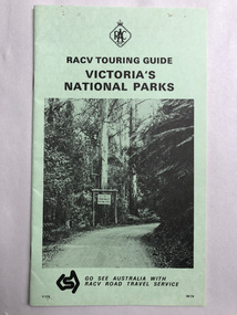
Pamphlet, RACV, Victoria's National Parks
... Victoria's National Parks ...walsh st library -
Victorian Aboriginal Corporation for Languages
Book, City of Whitehorse, City Of Whitehorse parks and reserves: names and origins, 1985
... City Of Whitehorse parks and reserves: names and origins ...Spiral bound book released by City of Whitehorse council. Alphabetically listed placenames within the local government area, with Melway map points and brief historical references to those places.Black and white photographs, colour photographsplace names, city of whitehorse, box hill, mitcham, mont albert, blackburn, surrey hills, burwood, nunawading, forest hill -
University of Melbourne, Burnley Campus Archives
Document, 42nd National Conference Melbourne 1969 - Australian Institute of Parks and Recreation, 1969
... Institute of Parks and Recreation ...Itinerary for conference, incl. visit to Burnleyconference, burnley -
Koorie Heritage Trust
Book, Brady, Elsie, They left their footprints : the origin of the names of streets and parks within Shepparton also names of various facilities on Council properties, or properties under Council management, where names have been given by or approved by Council, 1996
... streets and parks within Shepparton also names of various ...152 p. : ill., maps ; 24 cm. 1. street names -- victoria -- shepparton. 2. shepparton (vic.) -- history. -
Whitehorse Historical Society Inc.
Pamphlet, Nunawading parks and recreation information, c1982
... Nunawading parks and recreation information ...History, plans and leaflet concerning the Nunawading Horticultural Centre and the Community Gardens Cooperative.History, plans and leaflet concerning the Nunawading Horticultural Centre and the Community Gardens Cooperative.History, plans and leaflet concerning the Nunawading Horticultural Centre and the Community Gardens Cooperative.city of nunawading, horticultural centre, forest hill, nunawading community gardens -
Whitehorse Historical Society Inc.
Pamphlet, Parks and reserves, 1/09/1999 12:00:00 AM
... Parks and reserves ...Reports held in the Local History Collection, Nunawading Library, 3rd edition.Reports held in the Local History Collection, Nunawading Library, 3rd edition.Reports held in the Local History Collection, Nunawading Library, 3rd edition.parks and reserves, yarran dheran, wattle park, mullum mullum creek, schwerkolt cottage, slater reserve, trove park, vermont reserve, wandinong sanctuary, walker park, antonio park, mitcham, bellbird dell, blackburn lake sanctuary, bushy creek reserve, cootamundra walk, burwood east reserve, campbells croft, hale property, halliday park, highbury park, joseph street reserve, morack golf course -
 Whitehorse Historical Society Inc.
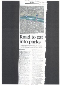
Article, Road to Eat Into Parks, 2018
... Road to Eat Into Parks ...Plans for the North East Link indicate parkland along Koonung Creek will go.Plans for the North East Link indicate parkland along Koonung Creek will go.Plans for the North East Link indicate parkland along Koonung Creek will go.north east link, koonung creek, blackburn north, eastern freeway, whitehorse active transport action group, city of whitehorse, bicycle paths -
 Whitehorse Historical Society Inc.
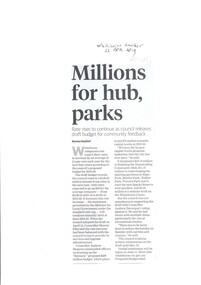
Article, Millions For Hub, Parks, 2019
... Millions For Hub, Parks ...Rate rises will increase by an average of 2.5 per cent each year for the next 4 years.Rate rises will increase by an average of 2.5 per cent each year for the next 4 years according to the Whitehorse Councils proposed budget for 2019 - 20 to fund the Nunawading Community Hub & redeveloping sporting pavilions.Rate rises will increase by an average of 2.5 per cent each year for the next 4 years. city of whitehorse, rates -
Ballarat Heritage Services
Book, Dhelkunya Dja Joint Management Plan for the Dja Dja Wurrung Parks: Strategy, 2018
... Parks: Strategy ...non-fictiondja dja wurrung, dhelkunya, cultural heritage, bushtucker, medicine, rivers, waterways, self-determination, joint management, crown land, native title, traditional owners, language -
 Whitehorse Historical Society Inc.
Document, City of Nunawading Parks & Recreation Dept. 83/84, 1983
... City of Nunawading Parks & Recreation Dept. 83/84 ...Budget 1983/84 for maintenance of Schwerkolt Cottagenon-fictionBudget 1983/84 for maintenance of Schwerkolt Cottagecity of nunawading, schwerkolt cottage -
 Queenscliffe Maritime Museum
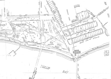
Map - Port Phillip Bay at Queenscliffe 1936, Map of Queenscliffe Parks & Foreshore, unknown
... Map of Queenscliffe Parks & Foreshore ...Queenscliffe life c1936Map of Queenscliffe in c1936copy of an L-shaped map of 1936 Queenscliffe foreshoreReverse - " nil ".historical references -
 Beechworth Honey Archive
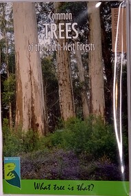
Publication, Common TREES of the South-West Forests (Judy Wheeler- Dept of Parks and Wildlife)First printed 1996, reprinted 2000,2003,2007,2016, 2016
... of Parks and Wildlife)First printed 1996, reprinted ...Soft Cover Slightly larger than A7 size, Picture on cover is Karri Forest with a flowering understorey 72 pages -
University of Melbourne, Burnley Campus Archives
Administrative record, John Patrick et al, Burnley Horticultural College Course in Parks and Recreation Administration and Management, 1981
... Burnley Horticultural College Course in Parks and ...john patrick, david aldous, diploma in applied science (amenity horticulture), parks and recreation, burnley college -
 Eltham District Historical Society Inc
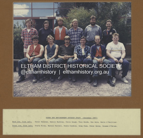
Photograph - Colour Print, Eltham Shire Council, Parks and Environment Outdoor Staff, December 1987
... Parks and Environment Outdoor Staff ...Back row, from left: Peter Renshaw, Dennis Buckley, Chris Gough, Tony Woods, Ron Gale, Kevin L'Huillier Front row, from left: Steve Riley, Bernie Farrell, Steve Condron , Greg Shaw, Peter Davey, Graeme O'Brien See also SEA_01-591bernie farrell, chris gough, council staff, dennis buckley, eltham shire council, graeme o'brien, greg shaw, kevin l'huillier, parks and environment, peter davey, peter renshaw, ron gale, staff, steve condron, steve riley, tony woods -
 Falls Creek Historical Society
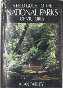
Book - A Field Guide to the National Parks of Victoria, Alan Fairley, January 1, 1982
... A Field Guide to the National Parks of Victoria ...This book serves as a comprehensive guide to reserves managed by the National Parks Service in Victoria, covering various aspects like history, geology, flora, fauna, and recreational activities. It divides Victoria into several parts, each with dedicated chapters for national parks, including detailed maps and entry points. Other reserves like State and coastal parks are grouped in a separate chapter. The content spans the diverse landscapes of Victoria, from Lower Glenelg to Burrowa Pine Mountain and the Alps to the desert, describing various types of soil, vegetation, animals, and natural beauty. It is intended for individuals who appreciate the outdoors, conservation, and bushwalking in the Australian bush.A volume of 363 pages 363 pages including 32 colour photos as well as illustrations and maps. It also includes a detailed index and bibliography. This book serves as a comprehensive guide to reserves managed by the National Parks Service in Victoria, covering various aspects like history, geology, flora, fauna, and recreational activities. It divides Victoria into several parts, each with dedicated chapters for national parks, including detailed maps and entry points. Other reserves like State and coastal parks are grouped in a separate chapter. The content spans the diverse landscapes of Victoria, from Lower Glenelg to Burrowa Pine Mountain and the Alps to the desert, describing various types of soil, vegetation, animals, and natural beauty. It is intended for individuals who appreciate the outdoors, conservation, and bushwalking in the Australian bush.national parks and reserves, environment victoria, national parks victoria guide -
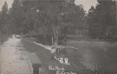 Rutherglen Historical Society
Photograph - Image, 1914-1920 (Approximate)
Showing different aspects of Lake King in Rutherglen ParkBlack & white photograph, unframed but pasted to pages of an album. A section of Lake King, which is situated in Rutherglen Park"The Park Rutherglen" -
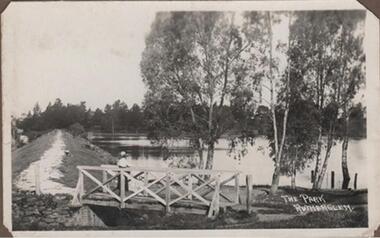 Rutherglen Historical Society
Photograph - Image, 1914-1920 (Approximate)
Showing different aspects of Lake King in Rutherglen ParkBlack & white photograph, unframed but pasted to pages of an album. A section of Lake King, which is situated in Rutherglen Park"The Park Rutherglen" -
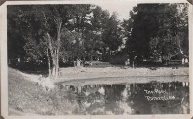 Rutherglen Historical Society
Photograph - Image, 1914-1920 (Approximate)
Showing different aspects of Lake King in Rutherglen ParkBlack & white photograph, unframed but pasted to pages of an album. A section of Lake King, which is situated in Rutherglen Park"The Park Rutherglen" -
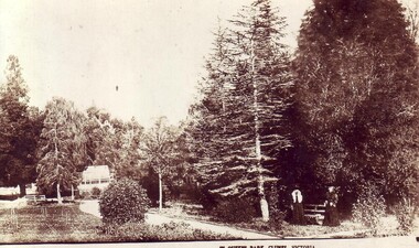 Clunes Museum
Photograph, BARNETT SERIES M583, QUEENS PARK
QUEEN'S PARK IN CLUNESSEPIA POSTCARD OF QUEEN'S PARK, CLUNES. TWO PEOPLE STANDING BY BENCH. BUILDING IN BACKGROUND.QUEEN'S PARK, CLUNES, VICTORIAlocal history, queen's park garden -
 Stawell Historical Society Inc
Photograph, Central Park Gardens 1988 --- 3 Photos -- Coloured
Three colour photographs Central Park Gardens Easter 1988Coloured photos of Central Park Gardens, one of No.1 Grandstand and the other two photos of the fountain in Central Park.Inscriptions on fountain postcards Easter flowers, Central Park Easter 1988stawell -
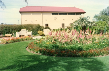
 Federation University Historical Collection
Programme, Greater London Council Parks Department, Victoria Embankment Gardens Band Stand Opening Concert, 23 May 1953
... Greater London Council Parks Department ...Frank Wright was a renown resident of Smeaton, where he was born on 2 August 1901. He lived at Laura Villa, and attended Smeaton State School. His father William was a gold miner and his mother's name was Sarah. Their family won many singing and instrumental awards. Frank was tutored by Percy Code and was awarded a gold medal for the highest marks in the ALCM examinations in the British Colonies at the age of seventeen years. He became the Australian Open Cornet Champion by the age of eighteen. A year later, Frank conducted the City of Ballarat Band, and later the Ballarat Soldiers’ Memorial Band. He formed the Frank Wright Frisco Band and Frank Wright and his Coliseum Orchestra. These bands won many South Street awards, and Frank as conductor won many awards in the Australian Band Championship contest. In 1933 Frank Wright sailed to England to conduct the famous St Hilda’s Band and was later appointed Musical Director of the London County Council, where he organized many amazing concerts in parks, in and around the London district. He was made Professor of Brass and Military Band Scoring and conducted at the Guildhall of Music and Drama. Frank was often invited to adjudicate Brass Band Championships around Europe, in Australia, including South Street and in New Zealand. The Frank Wright Medal at the Royal South Street competition is awarded to an individual recognized as making an outstanding contribution to brass music in Australia.Single page of think paper with black printing, containing the information about the concert held in 1953. It includes the name of the conductor - Frank Wright and the names of the representative bands along with the programme of music.frank wright, conductor, programme, brass band, victoria embankment gardens band stand -
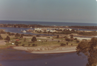 Lakes Entrance Historical Society
Photograph - View of Apex Park, Bullock Island, Lakes Entrance Victoria, 1/04/1979 12:00:00 AM
... Parks ...Bullock Island, Apex Park and cars parked on Marine Parade New Works area and Entrance channel in distance Lakes Entrance VictoriaColour photograph taken from Kalimna Heights showing road and bridge to Bullock Island, Apex Park and cars parked on Marine Parade New Works area and Entrance channel in distance Lakes Entrance Victoriaparks, business, islands -
 Kew Historical Society Inc
Photograph - Flooding in the Willsmere Park, 1993
Willsmere Park is bounded by the the Yarra River, Green Acres Golf Club, Willow Grove and the Eastern Freeway. The land on which the park is now situated was bought by Thomas Wills at the Crown Land Sales of 1846 (Section 56). From the 1840s to the 1940s it was intensively farmed. The park is dominated by very large playing fields, while planting to the southern boundary was undertaken when the Eastern Freeway was built. It is only along the banks of the Yarra that there is any remnant native vegetation. Willsmere Park is of significance as an area of open land that remains from the flood plain that once dominated northern Kew. (Source: Kew Conservation Study, 1988)Original colour small format polaroid photograph of flooding in the Willsmere Park, taken on 16 September 1993."Flooding of Willsmere Park from Yarra 16.9.93"willsmere park, yarra river -- floods -- kew (vic.) -
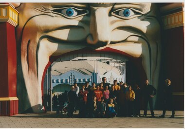 Melbourne Legacy
Photograph - Junior legatee outing, Luna Park, 2001
Three photos of a trip to Melbourne's Luna Park in 2001 for a group of junior legatees. The photos were mounted in an album of events that happened for Junior Legatees in 2001, including a trip to the Aquarium, a trip to Luna Park, horse riding and fishing and a Melbourne Legacy Leadership Group Christmas party. Melbourne Legacy arranged many events for Junior Legatees to experience. A record of the outings provided for Junior Legatees organised by Legacy.Colour photo x 3 of Junior Legatees on a trip to Melbourne's Luna Park in 2001.Yellow label printed 'Luna Park 2001'.junior legatee outing, amusement parks, junior legatees -
 Kew Historical Society Inc
Photograph - Studley Park, 1937
Those sections of Studley Park closest to the River Yarra were set aside as parkland in the 1850s. After initial discussions about whether it was a suitable site for a Government House, much of the land was instead gazetted in the 1860s as the location for a new lunatic asylum, to expand overcrowded mental health facilities at the Yarra Bend Asylum on the other side of the river at Fairfield. Those sections of Studley Park bounded by the Yarra River, Studley Park Road, Princess Street and Fellows Street were subdivided and sold at the Crown Land Sales in 1851. Much of this urban area remained open farmland until the twentieth century, apart from mansions, largely located along the main roads.Original, black and white positive print of what is said to represent Studley Park in 1937. If the attribution and date is literally to be understood, then it would appear that the photograph may have been taken from the Kew side of the river looking across to open farmland in the Yarra Bend Park. If the designation of Studley Park is to be understood more loosely, then it might be a view of what is now East Kew, taken from a section of Kilby Road. Inscribed verso: "Studley Park 1937" studley park -- kew (vic.) -
 Lakes Entrance Historical Society
Photograph - Apex Park , Lakes Entrance Victoria, L E Tidy Town Committee, 1994
... Parks ...Also two colour photographs of barbeques and seating at Apex Park numbers 04240.1 and 04240.2 size 10 x 15 cmColour photograph of Apex Park barbeque area with people seated at picnic tables, cars parked at Visitors Information Centre glimpsed through trees, Lakes Entrance Victoriaparks, gippsland lakes, recreation facilities -
Federation University Historical Collection
Document - Report, Ken Clements, Eureka Stockade Memorial Park Committee, 2012
The Eureka Stockade Park Committee were responsible for activities in the Park, and ran the Swimming Pool and Caravan Park. Five typed A4 pages of information relating to the Eureka Stockade Memorial Park Committee written by former committee member Ken Clements on the occasion of the committees centenary. In pencil on Front. 'UB' 'Eureka Stockade Memorial Park'eureka stockade memorial park committee, ken clements, eureka stockade -
 Kew Historical Society Inc
Photograph - Yarra River in flood at the Willsmere Park, 1993
Willsmere Park is bounded by the the Yarra River, Green Acres Golf Club, Willow Grove and the Eastern Freeway. The land on which the park is now situated was bought by Thomas Wills at the Crown Land Sales of 1846 (Section 56). From the 1840s to the 1940s it was intensively farmed. The park is dominated by very large playing fields, while planting to the southern boundary was undertaken when the Eastern Freeway was built. It is only along the banks of the Yarra that there is any remnant native vegetation. Willsmere Park is of significance as an area of open land that remains from the flood plain that once dominated northern Kew. (Source: Kew Conservation Study, 1988)Original colour small format polaroid photograph of the Yarra River in flood at the Willsmere Park, taken on 16 September 1993."Yarra River at Willsmere Park Flooding 16.9.93"willsmere park, yarra river -- floods -- kew (vic.) -
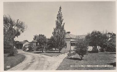 Phillip Island and District Historical Society Inc.
Photograph-postcard, Osbourne Park Guesthouse, Cowes, 1920's
One of two Photographs donated by Jean Archibald Osbourne Park was in Beach Street Cowes. It was replaced by Bayside Caravan Park, later Sails on Beach apartments. 2015Black & White photograph of "Osbourne Park", old Victorian weatherboard home in garden setting. Entrance drive in foreground leading to house and outbuilding at rear."Osbourne Park" Cowe, Phillip Island. V10old homesteads in cowes phillip island, osbourne park cowes, jean archibald, beach street cowes