Showing 25572 items matching "plenty-township-estate"
-
 Eltham District Historical Society Inc
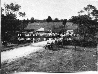
Negative - Photograph, Coghill & Haughton, Old bridge over the Plenty River near Plenty Hotel, c.1924
Negative copy and associated print of detail from original Sales Brochure: Plenty Township Estate and Bryn Teg Hill's Estate, Coghill & Haughton, Melbourne (c.1924)Roll of 35mm Black and White negative film, 3 strips, (1 of 14 frames) Print 10 x 15 cmFilm - Agfa Ortho 25bryn teg hill's estate, coghill & haughton, sales brochure, lower plenty, bridge, hotels, lower-plenty-road, plenty-hotel, plenty-river -
 Eltham District Historical Society Inc
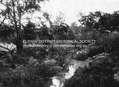
Negative - Photograph, Coghill & Haughton, Plenty River at Lower Plenty, c.1924
Negative copy and associated print of detail from original Sales Brochure: Plenty Township Estate and Bryn Teg Hill's Estate, Coghill & Haughton, Melbourne (c.1924)Roll of 35mm Black and White negative film, 3 strips, (1 of 14 frames) Print 10 x 15 cmFilm - Agfa Ortho 25bryn teg hill's estate, coghill & haughton, sales brochure, lower plenty, plenty river -
 Eltham District Historical Society Inc
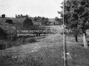
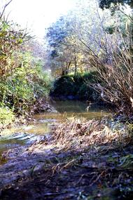
Negative - Photograph, Coghill & Haughton, Typical scene on the Plenty River at Lower Plenty, c.1924
Negative copy and associated print of detail from original Sales Brochure: Plenty Township Estate and Bryn Teg Hill's Estate, Coghill & Haughton, Melbourne (c.1924)Roll of 35mm Black and White negative film, 3 strips, (1 of 14 frames) Print 10 x 15 cmFilm - Agfa Ortho 25bryn teg hill's estate, coghill & haughton, sales brochure, lower plenty, plenty river -
 Greensborough Historical Society
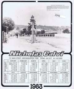
Calendar, Nicholas Calvi Real Estate, Nicholas Calvi Real Estate 1983, 1983_
1983 promotional calendar from Nicholas Calvi Real Estate Greensborough, showing image of Greensborough in the 1920s.Calendar, black and white text and image.nicholas calvi real estate -
 Eltham District Historical Society Inc
Photograph, Decorations for Queen Elizabeth II Coronation celebrations, Lower Plenty State School No. 1295, c. June 1953
Lower Plenty Prinary School decorated for Queen Elizabeth II's Coronation celebrations in Victoria. Shows the newer style Bristol classroomsBlack and white photograph of Bristol portable classroom at Lower Plenty School No. 1295Source: School at the crossing place, W.F. Hendersonschools, lower plenty, bristol classroom, main road, coronation, lower plenty state school no. 1295 -
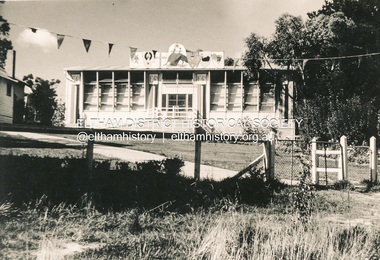
 Greensborough Historical Society
Photographs, Unknown, Lower Plenty Hall, 1960s
Views of Lower Plenty Hall prior to its demolition to make way for a carpark, near the corner of Para Road and Main Road Lower Plenty.Collection of 3 colour photographslower plenty hall -
 Linton and District Historical Society Inc
Photograph, Piggoreet Township
Piggoreet Township developed very quickly after gold was discovered in the Springdallah area (at that time called Spindella) in the 1850s. By the early 1860s the township had a population in the hundreds, as well as shops, a school, a police station and court house, hotels and churches.Copy of original photograph which shows roads, buildings, general layout of the former township at Piggoreet.piggoreet township -
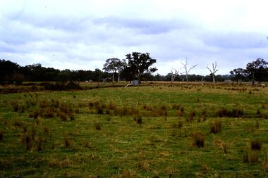 Greensborough Historical Society
Slide - Photograph, John Ramsdale, Flood plain of the Plenty River: Slide 90, 1990s
Photograph shows farmland on the flood plain of the Plenty River, north of MerndaPart of the John Ramsdale collection of slides and audio visual material.Colour photograph scanned from slide.No maker's marks. Caption on slide "Plenty"plenty river, mernda -
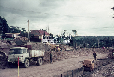 Eltham District Historical Society Inc
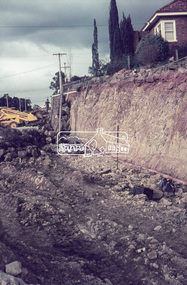
Slide, Looking southwest across to 184 Main Road, Lower Plenty during road widening works, 20 July 1970, 1970
Road works to widen and duplicate Main Road at Lower Plenty from top of hill near Grand Boulevard, Montmorency to shire border at Lower Plenty bridge35 mm colour positive transparency Mount - Agfacolor Service (Blue)duplication, lower plenty, main road, road construction -
 Eltham District Historical Society Inc
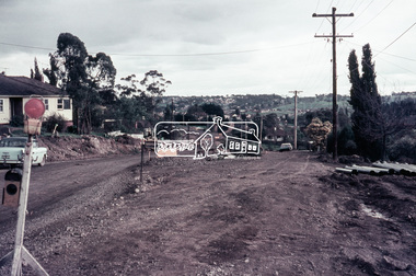
Slide, Looking east along Main Road, Lower Plenty near No. 184 during road widening works, 20 July 1970, 1970
Road works to widen and duplicate Main Road at Lower Plenty from top of hill near Grand Boulevard, Montmorency to shire border at Lower Plenty bridge35 mm colour positive transparency Mount - Agfacolor Service (Blue)duplication, lower plenty, main road, road construction -
 Eltham District Historical Society Inc
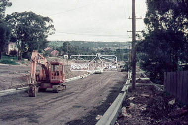
Slide, Looking southwest along Main Road, Lower Plenty near No. 169 during road widening works, 20 July 1970, 1970
Road works to widen and duplicate Main Road at Lower Plenty from top of hill near Grand Boulevard, Montmorency to shire border at Lower Plenty bridge35 mm colour positive transparency Mount - Agfacolor Service (Blue)duplication, lower plenty, main road, road construction -
 Eltham District Historical Society Inc
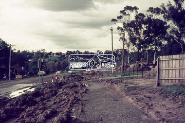
Slide, Looking southwest along Main Road, Lower Plenty near No. 167 during road widening works, 20 July 1970, 1970
Road works to widen and duplicate Main Road at Lower Plenty from top of hill near Grand Boulevard, Montmorency to shire border at Lower Plenty bridge35 mm colour positive transparency Mount - Agfacolor Service (Blue)duplication, lower plenty, main road, road construction -
 Eltham District Historical Society Inc
Slide, Looking northeast along Main Road, Lower Plenty near No. 122 during road widening works, 20 July 1970, 1970
Road works to widen and duplicate Main Road at Lower Plenty from top of hill near Grand Boulevard, Montmorency to shire border at Lower Plenty bridge35 mm colour positive transparency Mount - Agfacolor Service (Blue)duplication, lower plenty, main road, road construction -
 Greensborough Historical Society
Slide - Photograph, John Ramsdale, Plenty River behind football ground: Slide 51, 1990s
Photograph shows a river and bushland. This is the Plenty River behind the football ground in Greensborough.Part of the John Ramsdale collection of slides and audio visual material.Colour photograph scanned from slide.No maker's marks. Caption on slide "Plenty"plenty river greensborough, plenty river -
 Marysville & District Historical Society
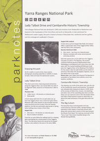
Flyer (item) - Information Flyer, Parks Victoria, park notes-Yarra Ranges National Park-Lady Talbot Drive and Cambarville Historic Township, June 2013
A flyer produced by Parks Victoria of information on Lady Talbot Drive and Cambarville Historic Township.A flyer produced by Parks Victoria of information on Lady Talbot Drive and Cambarville Historic Township. Lady Talbot Drive a 24 kilometer scenic rainforest car journey which passes a number of walks and waterfalls in the Yarra Ranges National Park. Lady Talbot Drive is named after Lady Sarah Elizabeth, the wife of Sir Reginald Talbot, who was the Governor of Victoria from 25th April, 1904 to 6th July 1908. Cambarville is notable for its giant mountain ash (Eucalyptus regnans) trees within the Cumberland Memorial Scenic Reserve, and relics from former sawmills and gold mining. The Big Culvert is located nearby on the Marysville-Woods Point Road, which was historically part of the Yarra Track. Cambarville was established as a timber mill town in the 1940s. Timber mill owners A Cameron and FJ Barton named Cambarville. They established the mill to salvage timber from trees destroyed in the 1939 bushfires. Cambarville was impacted by the 2009 Black Saturday bushfires and any remaining structures were destroyed. parks victoria, yarra ranges national park, lady talbot drive, lady talbot forest drive, cambarville, taggerty river, sir reginald talbot, lady sarah elizabeth talbot, phantom falls, keppel falls, keppel falls lookout, beeches rainforest walk, big culvert, cumberland walk, the big tree, the sitka spruce, cora lynn falls, sovereign view -
 Marysville & District Historical Society
Ephemera (Item) - Information brochure, Artworkz Tourism, MARYSVILLE TOWNSHIP, 11-2020
An information brochure on the township of Marysville in Victoria. This brochure was produced by Artworkz Tourism in November 2020.An information brochure on the township of Marysville in Victoria.Disclaimer: The authors have taken care to ensure this/ publication is correct, though please be aware that/ errors and omissions do occur.marysville, victoria, australia, information brochure, artworkz tourism, 2009 black saturday bushfires, bruno's sculpture garden, steavenson falls, gallipoli lake, keppel falls, lady talbot drive, cora lynn falls, cambarville walk, phantom falls, taggerty river visitor area, meeting of the waters, the beeches, cambarville day visitor area, the big tree, keppel hut, keppel lookout, mount gordon, marysville golf course, jock's lookout, gallipoli park, yellow dog day visitor area -
 Eltham District Historical Society Inc
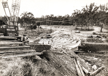
Photograph, Construction of new bridge over the Plenty River, Main Road, Lower Plenty, c.Aug. 1966
Construction of the Main Road bridge over the Plenty River. Includes structural members, construction personnel, vehicles and a Clarke mobile crane.Local significanceBlack and white printMarking on back of photograph - Plenty River Bridge Main Road 1969 (sic)lower plenty, main road, plenty river, bridge, bridge construction, civil engineering, cranes, mobile cranes -
 Sherbrooke Foothills Historical Society
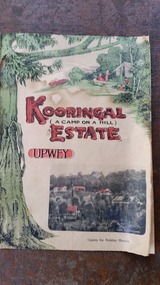
Kooringal Estate Upwey sales brochure
Kooringal Estate Upwey sales brochureEstate agents Coghill & Haughton -
 Greensborough Historical Society
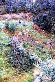
Slide - Photograph, John Ramsdale, Slumping erosion along the Plenty River: Slide 110, 1990s
Photograph shows a man standing on an embankment which is being eroded. This is slumping erosion along the Plenty River.Part of the John Ramsdale collection of slides and audio visual material.Colour photograph scanned from slide.No maker's marks. Caption on slide "Plenty"plenty river, erosion -
 Greensborough Historical Society
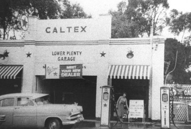
Photograph - Digital Image, Lower Plenty Garage, 1950s
Lower Plenty Garage (a Caltex service station) on Main Road Lower Plenty (previously Old Eltham Road) in the 1950s. This photograph shows the garage with petrol pumps out front and a Caltex sign above door.Digital copy of black and white photographlower plenty, lower plenty garage, main road lower plenty, old eltham road lower plenty, caltex garage lower plenty -
 Marysville & District Historical Society
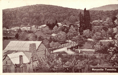
Postcard (item) - Black and white postcard, Marysville Township, 1936
A digital copy of a black and white postcard of the view of the Marysville township taken from the Steavenson Hotel.A digital copy of a black and white postcard of the view of the Marysville township taken from the Steavenson Hotel.marysville, victoria, australia, steavenson hotel, poontawan, marysville chalet, george wright, pack road, wood's point road, wood's point mountaineer, albion restaurant, steavenson's creek, yarra track, bridge inn, butler's woods point general directory 1866, postcard -
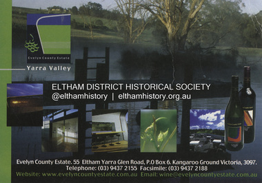
 Eltham District Historical Society Inc
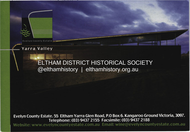
Postcard - Photograph, Evelyn County Estate, Evelyn County Estate, Yarra Valley, c.2009
The Evelyn Country Estate, Cellar Door and Black Paddock restaurant and Tony Smibert Gallery opened on 26 April 2001 and officially opened on 18 May 2001 by Roger and Robyn Male - KGC Winter 2001evelyn county estate, kangaroo ground, postcard, yarra valley, restaurant -
 Eltham District Historical Society Inc
Postcard - Photograph, Evelyn County Estate, Evelyn County Estate, Yarra Valley, c.2009
The Evelyn Country Estate, Cellar Door and Black Paddock restaurant and Tony Smibert Gallery opened on 26 April 2001 and officially opened on 18 May 2001 by Roger and Robyn Male - KGC Winter 2001evelyn county estate, kangaroo ground, postcard, yarra valley, restaurant -
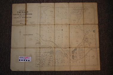 Emerald Museum & Nobelius Heritage Park
Two maps of Emerald Township 1955 and 1922, Emerald Township
The Photo Lithographed Maps belonged to George and Mary A'Vard. They are early maps of Emerald Township in 1955 and 1922.VEMU1659.1 Township of Emerald, Parish of Gembrook, Counties of Evelyn and Mornington; September 1955 VEMU1659.2 Township of Emerald, Parish of Gembrook, Counties of Evelyn and Mornington: Drafted 12 Sep 1892, Examined 30 Sep 1892, Additions 17 Jun 1922 -
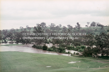 Eltham District Historical Society Inc
Slide, Floodwater, west from Clubhouse of Rosanna Golf Club, Lower Plenty, November 1971, 1971
Many parts of Melbourne flooded including Rosanna Golf Club, Lower Plenty in Novembere 1971. Many surburban roads, including the new south-eastern freeway were cut by flood waters. Here the level of the Plenty River floods onto the golf course. 35 mm colour positive transparency Mount - Agfacolor Service (Blue)floods, lower plenty, rosanna golf club, flooding, plenty river -
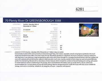 Greensborough Historical Society
Advertising Leaflet, Barry Plant Greensborough, 70 Plenty River Drive Greensborough, 31/10/2018
Real estate advertisement for 70 Plenty River Drive Greensborough, a 3 bedroom house.This house was listed in February 2019 for $650,000-$700,000. Previous sales: March 2004 for $280,000.Real estate advertisement black text and colour photographplenty river drive greensborough -
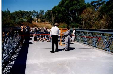 Greensborough Historical Society
Photograph - Digital Image, Anne Paul, Opening of restored Old Lower Plenty Bridge 2001, 14/03/2001
The opening of the restored Old Lower Plenty Bridge, opened on 14/03/2001 by the Minister for Environment and Conservation Sherryl Garbutt MLA and Mayor of Banyule Cr Dale Peters. The project was jointly funded by Banyule Council and Parks Victoria. The restored bridge is the oldest remaining bridge in the former Shire of Eltham and forms part of the Plenty River Trail.Digital copy of colour photographlower plenty, lower plenty bridge, sherryl garbutt, dale peters, banyule council, parks victoria -
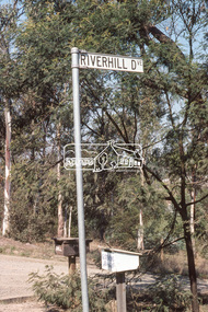 Eltham District Historical Society Inc
Photograph, Riverhill Drive intersection with Rosehill Road, Lower Plenty, c.March 1981, 1981
Infrastructure features used by Eltham Shire Council in the construction of Riverhill Drive, Lower Plenty, c.March 198135mm colour positive transparency Kodak Kodachrome cardboard mountbell, g. stevens, infrastructure, lower plenty, riverhill drive, road construction, rosehill road, streets -
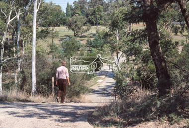 Eltham District Historical Society Inc
Photograph, Looking down Riverhill Drive from intersection of Rosehill Road, Lower Plenty, c.March 1981, 1981
Infrastructure features used by Eltham Shire Council in the construction of Riverhill Drive, Lower Plenty, c.March 198135mm colour positive transparency Kodak Kodachrome cardboard mountinfrastructure, lower plenty, riverhill drive, road construction, rosehill road, streets