Showing 251 items matching "railway department"
-
 Port Melbourne Historical & Preservation Society
Photograph - Bay Street south, Sandridge, 1870s
... Department at Port Melbourne Town Hall at 19-9-1994. This set of prints belonged to Town Clerk Syd ANDERSON, then to his daughter-in-law Phyllis ANDERSON (donor). Accompanied by list of captions, both hand written and typed (the latter a partial listing). Market Reserve Religion - Wesleyan Methodist Church Sydney Sims ANDERSON Town Clerks Bay Street Liardet Street "P. Anderson" ink, on back. Empty market site from roof across Liardet Street, showing Bay Street south, Post Office, Town and Railways ...One of a series assembled for the Melbourne Exhibition of 1873, original mount hanging in Engineering Department at Port Melbourne Town Hall at 19-9-1994. This set of prints belonged to Town Clerk Syd ANDERSON, then to his daughter-in-law Phyllis ANDERSON (donor). Accompanied by list of captions, both hand written and typed (the latter a partial listing).Empty market site from roof across Liardet Street, showing Bay Street south, Post Office, Town and Railways piers, Wesley Methodist Church. 1870s"P. Anderson" ink, on back.market reserve, religion - wesleyan methodist church, sydney sims anderson, town clerks, bay street, liardet street -
Port Melbourne Historical & Preservation Society
Photograph - Sandridge Beach, 1871
... Department at Port Melbourne Town Hall at 19-9-1994 but now in Port Phillip,City Collection. This set of original prints belonged to Town Clerk Syd ANDERSON, then to his daughter-in-law Phyllis ANDERSON (donor). Accompanied by list of captions, both hand written and typed (the latter a partial listing). Piers and Wharves - Town Pier Piers and Wharves - Railway ...Photographed in 1872 by William PATERSON as one of a series for the Melbourne Exhibition of 1873; original mount hanging in Engineering Department at Port Melbourne Town Hall at 19-9-1994 but now in Port Phillip,City Collection. This set of original prints belonged to Town Clerk Syd ANDERSON, then to his daughter-in-law Phyllis ANDERSON (donor). Accompanied by list of captions, both hand written and typed (the latter a partial listing).View of Beach and piers from Sugar Works, c1871, showing Railway and Town Piers and two jetties in between (caption refers to Donaldson's Jetty), Pier Hotel, gates and some of the yard of the Victorian Sugar Works, and site where Morley's Coal Depot will soon be built, its timber stable and workshop occupied at the time by Carl SEISMAN, mail contractor and owner of the Royal Mail Hotel next door (unseen). The first curved roofed shed can be seen at Town Pier; this remained until demolition in the 1950s. The Post Office Boat House is also visible just before the first small jetty (which is at the place where Alfred LINGHAM's Marine Hotel - the first in the area, 1840 - had its jetty). In the extreme distance Watson's Baths are just visible."P. Anderson" ink, on back.:"7" ink, on face, upper left.piers and wharves - town pier, piers and wharves - railway pier, piers and wharves - donaldson's jetty, sydney sims anderson, town clerks, carl frederick julius seismann, bay street, business and traders - hotels -
Port Melbourne Historical & Preservation Society
Photograph - Station Hotel, Sandridge, Roger Gould?, 1871
... Department at Port Melbourne Town Hall at 19-9-1994 but now in Port Phillip,City Collection. This set of original prints belonged to Town Clerk Syd ANDERSON, then to his daughter-in-law Phyllis ANDERSON (donor). Accompanied by list of captions, both hand written and typed (the latter a partial listing). Religion - Presbyterian Church Costume Transport - Horse Parks and Gardens Sydney Sims ANDERSON Town Clerks Bridge Street Railway ...Photographed in 1872 by William PATERSON as one of a series for the Melbourne Exhibition of 1873; original mount hanging in Engineering Department at Port Melbourne Town Hall at 19-9-1994 but now in Port Phillip,City Collection. This set of original prints belonged to Town Clerk Syd ANDERSON, then to his daughter-in-law Phyllis ANDERSON (donor). Accompanied by list of captions, both hand written and typed (the latter a partial listing). Glossy print, copy of photo c1871 of early Station Hotel from the footbridge over the railway line, prior to extension of Bridge Street over the railway. Shows Presbyterian Church, carriages, a number of people, geese on the Railway Reserve.religion - presbyterian church, costume, transport - horse, parks and gardens, sydney sims anderson, town clerks, bridge street, railway reserve, business and traders - hotels -
Port Melbourne Historical & Preservation Society
Plan - Open drainage channel, cnr Beach Street and Railway Place, Port Melbourne, Frederick William Bull, Principal Surveyor, 1862
... Port Melbourne Historical & Preservation Society Port Melbourne Town Hall 333 Bay Street Port Melbourne melbourne Engineering - Canals and Drainage Engineering Department - Borough of Sandridge Frederick William BULL Business and Traders - Hotels "Open Channel at Foot of Railway Place":Signed by Frederick William Bull, Principal Surveyor Plan for open drainage channel at corner of Beach Street and Railway Place, 1892. ...Plan for open drainage channel at corner of Beach Street and Railway Place, 1892."Open Channel at Foot of Railway Place":Signed by Frederick William Bull, Principal Surveyorengineering - canals and drainage, engineering department - borough of sandridge, frederick william bull, business and traders - hotels -
Port Melbourne Historical & Preservation Society
Plan - Port Melbourne, 1882
... Port Melbourne Historical & Preservation Society Port Melbourne Town Hall 333 Bay Street Port Melbourne melbourne Town Planning Fishermans Bend Sandridge Lagoon Transport - Railways Large, deteriorated 1882 plan of Port Melbourne, Parish of South Melbourne, County of Bourke - showing Town Lots. Pasted onto board. Plan Port Melbourne Department ...Large, deteriorated 1882 plan of Port Melbourne, Parish of South Melbourne, County of Bourke - showing Town Lots. Pasted onto board.town planning, fishermans bend, sandridge lagoon, transport - railways -
Port Melbourne Historical & Preservation Society
Plan - Proposed land sub-division, west of railway, Sandridge, 19 Nov 1866
... Plan Proposed land sub-division, west of railway, Sandridge Department of Lands and Surveys ...1866 plan of proposed sub-division of land at Sandridge, west of railway. Includes manure depot.J. Noone (Photolithographer, Dept. of Lands and Survey) J. Hardy (Assistant Surveyor)town planning, town planning - proposals shelved, j noone, j hardy -
 Bendigo Historical Society Inc.
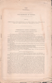
Document - UNDERGROUND SURVEY OF BENDIGO MINES
... History House 11 Mackenzie Street Bendigo goldfields BENDIGO Mining garden gully line of reef mines Jems Stirling, geologist and W.H Cundy Underground Surveyor, Department of Mines Two page document, 'Underground survey of Bendigo, report on Constellation Company's Mine on northern extension of the Garden Gully line of reef. Report on the New Chum Railway ...Two page document, 'Underground survey of Bendigo, report on Constellation Company's Mine on northern extension of the Garden Gully line of reef. Report on the New Chum Railway Reserve Company and the Shenandoah Company, the New Chum Railway Co being immediately south and the Shenandoah Co immediately north of the railway line. Two maps Constellation Co. Mine shaft and New Chum Railway and Shenandoah auriferous reef below 2700 feet.Jems Stirling, geologist and W.H Cundy Underground Surveyor, Department of Minesbendigo, mining, garden gully line of reef mines -
 Otway Districts Historical Society
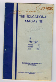
Periodical, Education Department, Victoria, The Education Magazine, Vol.19 No. 6, July 1962, July 1962
... Department of Victoria. Vol.19, No. 6 contains one article of particular relevance, A Train and History, written by Frank McCabe. education; magazine; railways; articles; history; The Educational Magazine, Volume 19, Number 6, July 1962. ...The Educational Magazine is a monthly magazine of educational articles, Australian and overseas, published for teachers by the Education Department of Victoria. Vol.19, No. 6 contains one article of particular relevance, A Train and History, written by Frank McCabe. The Educational Magazine, Volume 19, Number 6, July 1962. The Education Department of Victoria; Melbourne (Vic); 1962. 47 p.; illus, map. Soft cover.education; magazine; railways; articles; history; -
 Otway Districts Historical Society
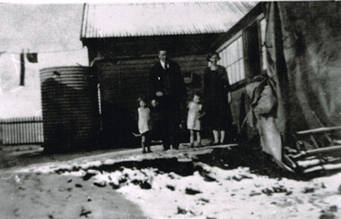
Photograph, Laurie McCabe, wife and children at their railway house, Beech Forest, Mid 1920s
... He was based in Beech Forest and housed departmentally with his wife, Victoria Elizabeth (nee Tann) and their two children. beech forest; railway; departmental housing; Laurie McCabe, Travelling Station Master and goods Guard, his wife, Victoria, and their two children outside their railway house at Beech Forest. ...In order to accommodate its key Otways staff of train crews, station masters and gangers the VR provided departmental housing. Laurie McCabe, a former porter at Wyelangta, a player in the local football team, and married to one of the potato-growing families, was the Station Master becoming the travelling station master and guard in 1930. He was based in Beech Forest and housed departmentally with his wife, Victoria Elizabeth (nee Tann) and their two children.Laurie McCabe, Travelling Station Master and goods Guard, his wife, Victoria, and their two children outside their railway house at Beech Forest. B/W.beech forest; railway; departmental housing; -
 Otway Districts Historical Society
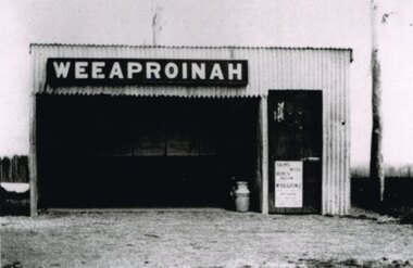
Photograph, R. Preston, Weeaproinah mallee shed, c.1920, c.1920
... railway became earlier 'Dinmont' in the Olangolah Parish.) The station comprised a passenger shelter and a loop siding with a ramped platform for a sheep and pig race. A departmental...departmental residence until 1930. Weeaproinah became an unattended crossing station in December 1927 under the Train Section Order system. weeaproinah; railways; shed; B/W. ...Originally named 'McInnes' after a local selector, this station opened during construction of the Crowes railway on 1 May 1911. The name was altered to Weeaproinah, the second station of that name, on 9 December 1912, after the parish in which the station was situated. (The original 'Weeaproinah' on the railway became earlier 'Dinmont' in the Olangolah Parish.) The station comprised a passenger shelter and a loop siding with a ramped platform for a sheep and pig race. A departmental residence was built for a track repairer based at the station, but no station or caretaker staff were employed there. The residence was burnt down during the 1919 bushfire but it was replaced and remained in use as a departmental residence until 1930. Weeaproinah became an unattended crossing station in December 1927 under the Train Section Order system.B/W. Weeaproinah mallee shed. In the shed there are five large wall-mounted posters and a cream can. An unlocked door with a "Skins / Hides" poster gives access the inside. A tree trunk stands to the right.weeaproinah; railways; shed; -
 Otway Districts Historical Society
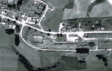
Photograph, R. Preston, Aerial view of Beech Forest railway station and yards, 1965, 13 February 1965
... railways; township; aerial; B/W. An aerial view of Beech Forest showing the balloon loop at the end of the station yard (enclosing the two tennis courts), two ex-departmental residences, the station buildings, and other aspects of the township. ...B/W. An aerial view of Beech Forest showing the balloon loop at the end of the station yard (enclosing the two tennis courts), two ex-departmental residences, the station buildings, and other aspects of the township.beech forest: railways; township; aerial; -
 Otway Districts Historical Society
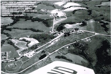
Photograph, R. Preston, Aerial view: Beech Forest, 1965, 13 February 1965
... railways; township; aerial; B/W. Aerial view of Beech Forest showing the complete station yard including the balloon loop (incorporating the two tennis courts), two ex-departmental residences, the station building and where the Colac and Crowes lines diverged. ...B/W. Aerial view of Beech Forest showing the complete station yard including the balloon loop (incorporating the two tennis courts), two ex-departmental residences, the station building and where the Colac and Crowes lines diverged. As well Beech Forest Hall, council offices and Shire Secretary's house, Denherts Track, and Main Road are shown.beech forest; railways; township; aerial; -
 Otway Districts Historical Society
Photograph, Crowes: Terminus of the railway line, 1911
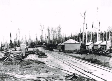
... railway, and the southern-most station on the Australian mainland, was Crowes, approximately 2 kilometres from Lavers Hill. The line ended at "The Black Stump". Crowes was designed as a fully functioning terminus and received a complete instalment of facilities. The site was laid out with three roads plus a dead end siding for a locomotive shed and ash pit. Goods sheds, a platform and livestock ramps catered for freight loadings, while on the north side was a station office, waiting room, parcels shed and passenger shelter. Three departmental...railway, and the southern-most station on the Australian mainland, was Crowes, approximately 2 kilometres from Lavers Hill. The line ended at "The Black Stump". Crowes was designed as a fully functioning terminus and received a complete instalment of facilities. The site was laid out with three roads plus a dead end siding for a locomotive shed and ash pit. Goods sheds, a platform and livestock ramps catered for freight loadings, while on the north side was a station office, waiting room, parcels shed and passenger shelter. Three departmental ...The terminus of the railway, and the southern-most station on the Australian mainland, was Crowes, approximately 2 kilometres from Lavers Hill. The line ended at "The Black Stump". Crowes was designed as a fully functioning terminus and received a complete instalment of facilities. The site was laid out with three roads plus a dead end siding for a locomotive shed and ash pit. Goods sheds, a platform and livestock ramps catered for freight loadings, while on the north side was a station office, waiting room, parcels shed and passenger shelter. Three departmental residences were also provided. The resident Station Master was withdrawn in November 1916 and the station closed with the line on 10 December 1954.Photograph. Terminus of the Colac-Crowes at Crowes.crowes; terminus; "the black stump"; -
 Otway Districts Historical Society
Photograph, Beech Forest Railway Station, 1903, 1903
... In 1903, before the extension to Crowes, Beech Forest Railway Station was the terminus, already 3 roads wide with Station building, outshed, Goods Shed, and three small departmental residences. ...Otway Districts Historical Society Cliff Young Drive Beech Forest great-ocean-road In 1903, before the extension to Crowes, Beech Forest Railway Station was the terminus, already 3 roads wide with Station building, outshed, Goods Shed, and three small departmental residences. ...In 1903, before the extension to Crowes, Beech Forest Railway Station was the terminus, already 3 roads wide with Station building, outshed, Goods Shed, and three small departmental residences. An NQR wagon near the Goods Shed is loading timber while a further NQR wagon sits outside the station building.Photograph, B/W, 174mm x 267mm. Beech Forest Railway Station, 1903.beech forest; railways; station; -
Port Melbourne Historical & Preservation Society
Document - Presentation kit, 150th Anniversary M&HB Railway, Victorian Department of Infrastructure, Aug 2004
... Railway Pier...Peter Batchelor...Department...(May be missing August 2013) Document Presentation kit, 150th Anniversary M&HB Railway Victorian Department of Infrastructure ...Kit presented to attendees at celebratory breakfast for 150th Anniversary of the M&HB railway, in pink & copper. .02: Invitation to the breakfast .03: Badge '150 Victoria' gold coloured .04: Set of 4 railway postcards ('maximum cards') .05: Fridge magnet from PROV (grey & black) .06: Card designating table 16, where 9 PMH&PS members sat .07: "Sandridge Railway Trail" - DL tour guide .08: "Making Tracks" - DL brochure about RHSV exhibition .09: "Stampspotting" - DL exhibition brochure (Aust Post) .10: "Rebuilding Regional Rail" - A4 brochure re new developments in Vic Rail .11: "Celebrating the 150th Anniversary of Victorin Railways" - double-sided A4 fact sheet, copper & pink .12: Seven related media releases from various auhorities .13 RHSV form for telling railway stories. (May be missing August 2013)transport - railways, piers and wharves - station pier, piers and wharves - railway pier, peter batchelor, department of infrastructure, melbourne & hobsons bay railway -
Port Melbourne Historical & Preservation Society
Photograph - Railway Reserve, Sandridge, William Paterson, 1870s
... Department at Port Melbourne Town Hall at 19-9-1994. This set of prints belonged to Town Clerk Syd ANDERSON, then to his daughter-in-law Phyllis ANDERSON (donor). Accompanied by list of captions, both hand written and typed (the latter a partial listing). Transport - Railways ...One of a series assembled for the Melbourne Exhibition of 1873, original mount hanging in Engineering Department at Port Melbourne Town Hall at 19-9-1994. This set of prints belonged to Town Clerk Syd ANDERSON, then to his daughter-in-law Phyllis ANDERSON (donor). Accompanied by list of captions, both hand written and typed (the latter a partial listing). View from pedestrian bridge over railway, looking southeast over 'ornamental' Railway Reserve, 1870s. Probably taken from footbridge just north of Raglan Street; open space is believed to be swamp drainage area between Raglan and Spring Street. (Location usually attributed to Farrell Street - i.e. taken from footbridge at Bridge and Station, but this proves unlikely as there had been no construction on the swamp between Bridge and Farrell until later.)"P. Anderson" ink, on back:"10" ballpoint, on upper left face of phototransport - railways, built environment, parks and gardens, sydney sims anderson, town clerks, railway reserve, station street -
Port Melbourne Historical & Preservation Society
Book, Jill Barnard et al, "Welcome & Farewell - The Story of Station Pier", Aug 2004
... Railway and Station Piers. Copper coloured cover and dust cover, hardback, 206 pp. Index, Bibliography, Chronology and extensive references. Signed by co-authors and Station Pier Manager "Welcome & Farewell - The Story of Station Pier" Book Jill Barnard Sonia Jennings Victorian Department of Infrastructure Arcadia, an imprint of Australia Scholarly Publishing P/L ...Donated to the PMH&PS by the authors, at the launch on Station Pier (occasion of 150th birthday of Railway Pier), 12th September 2004. (Ref 1948.01 for picture of authors at launch)."Welcome & Farewell - The Story of Station Pier" - a large, lavishly illustrated history of early Sandridge Railway and Station Piers. Copper coloured cover and dust cover, hardback, 206 pp. Index, Bibliography, Chronology and extensive references. Signed by co-authors and Station Pier ManagerSigned by co-authors Jill Barnard and Sonia Jennings, and Station Pier Manager Evda Marangospiers and wharves - railway pier, piers and wharves - station pier, transport - shipping, transport - railways, immigration, jill barnard, sonia jennings -
Port Melbourne Historical & Preservation Society
Document - Presentation kit, 150th Anniversary of M&HB railway, Victorian Department of Infrastructure, Aug 2004
... Railway Pier...Peter Batchelor...Department...Document Presentation kit, 150th Anniversary of M&HB railway Victorian Department of Infrastructure ...Kit presented to attendees at celebratory breakfast for 150th Anniversary of the M&HB railway, in pink & copper. transport - railways, piers and wharves - station pier, piers and wharves - railway pier, peter batchelor, department of infrastructure, melbourne & hobsons bay railway -
Port Melbourne Historical & Preservation Society
Badge - 150 Victoria, Victorian Department of Infrastructure, Aug 2004
... Railway Pier...Peter Batchelor...Department...Port Melbourne Historical & Preservation Society Port Melbourne Town Hall 333 Bay Street Port Melbourne melbourne Transport - Railways Piers and Wharves - Station Pier Piers and Wharves - Railway Pier Peter Batchelor Department of Infrastructure Melbourne & Hobsons Bay Railway Kit presented to attendees at celebratory breakfast for 150th Anniversary of the M&HB railway, in pink & copper. .03: Badge '150 Victoria' gold coloured Badge 150 Victoria Victorian Department of Infrastructure ...Kit presented to attendees at celebratory breakfast for 150th Anniversary of the M&HB railway, in pink & copper. .03: Badge '150 Victoria' gold coloured transport - railways, piers and wharves - station pier, piers and wharves - railway pier, peter batchelor, department of infrastructure, melbourne & hobsons bay railway -
Port Melbourne Historical & Preservation Society
Map - Melbourne and suburbs, Department of Lands and Survey, 1 May 1934
... Port Melbourne Historical & Preservation Society Port Melbourne Town Hall 333 Bay Street Port Melbourne melbourne melbourne south melbourne transport - tramways transport - railways Large printed map of Melbourne and suburbs 1936 showing historic sights Map Melbourne and suburbs Department of Lands and Survey ...Large printed map of Melbourne and suburbs 1936 showing historic sightsmelbourne, south melbourne, transport - tramways, transport - railways -
 Bendigo Historical Society Inc.
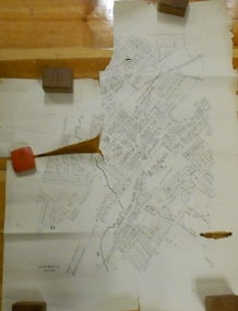
Document - MARKS COLLECTION: PLAN OF SANDHURST CITY CENTRE AND SURROUNDING AREA ( NO. 1 )
... railway reserve. Landowners' names on allotments. On bottom lithographed at the Department of Lands and Survey, Melbourne, by D. ...railway reserve. Landowners' names on allotments. On bottom lithographed at the Department of Lands and Survey, Melbourne, by D. ...Plan on heavy parchment - section neatly cut out of area now Kennington. Written on plan in black print ' Sheet No. 1. Sandhurst'. Plan shows Government Camp, Commissioner's Gully, old cemetery site, manure depot, cattle market, Benevolent Asylum Reserve, railway reserve. Landowners' names on allotments. On bottom lithographed at the Department of Lands and Survey, Melbourne, by D. Henerson, March 12th., 1867 Plan part of George Lansell, Fortuna auction, documents found in wardrobe purchased by Marks family in 1930's.bendigo, planning, sandhurst 1867 -
 Bendigo Historical Society Inc.
Document - MERLE BUSH COLLECTION: FOOD RELATED MATERIAL OF MERLE BUSH
... Department of Public Health Food related material of Merle Bush. Booklet (x2) ''Food - Feeding the Child for Health'' (approved by the director of Infant Welfare, Public health Dept.; 54 pages, 1937; b. ''Venereal Diseases - Information relating to Venereal Diseases and Duties of patients'' ; Public Health Dept, Victoria (no date); c. ''Are You Interested in Food?'' by the Victorian Railways ...Food related material of Merle Bush. Booklet (x2) ''Food - Feeding the Child for Health'' (approved by the director of Infant Welfare, Public health Dept.; 54 pages, 1937; b. ''Venereal Diseases - Information relating to Venereal Diseases and Duties of patients'' ; Public Health Dept, Victoria (no date); c. ''Are You Interested in Food?'' by the Victorian Railways' Dietician, 1936; d. ''The Feeding of Children'' pamphlet by the Public Health Dept., Victoria 1927government, state, department of public health -
Bendigo Historical Society Inc.
Map - KNOWSLEY : COUNTY OF BENDIGO, 7-11-1941
... Railway, Kilmore-Heathcote-Bendigo Road. Knowsley Station Ground. Shingle Hut Creek, Forest Creek. By authority H.E. Daw, Government Printer, Melbourne. Drawn and reproduced at the Department...Railway, Kilmore-Heathcote-Bendigo Road. Knowsley Station Ground. Shingle Hut Creek, Forest Creek. By authority H.E. Daw, Government Printer, Melbourne. Drawn and reproduced at the Department ...Map. Knowsley, County of Bendigo, County of Rodney, Weston, Axedale, Eppalock, Knowsley East, Langwornor, Heathcote, Campaspe River, Mt. Ida Creek or Wild Duck Creek, Sandhurst and Heathcote Railway, Kilmore-Heathcote-Bendigo Road. Knowsley Station Ground. Shingle Hut Creek, Forest Creek. By authority H.E. Daw, Government Printer, Melbourne. Drawn and reproduced at the Department of Lands and Survey, Melbourne. 7-11-1941. Price 2/-. (number 103 in map cupboard 1)H.E. Daw, Government Printer, Melbourne.map, bendigo, knowsley -
Bendigo Historical Society Inc.
Map - KNOWSLEY : COUNTY OF BENDIGO, 21-1-19
... Railway, Mt. Ida Creek. By authority A.J. Mullett, Government Printer, Melbourne. Photo-Lithographed at the Department of Lands and Survey, Melbourne by W.J. ...Railway, Mt. Ida Creek. By authority A.J. Mullett, Government Printer, Melbourne. Photo-Lithographed at the Department of Lands and Survey, Melbourne by W.J. ...Map. Knowsley, County of Bendigo, County of Rodney, Weston, Crosbie, Knowsley, Dargile, Heathcote, Shingle Hut Creek, Sheep Station Creek, Forest Creek, Bendigo and Wallan Railway, Mt. Ida Creek. By authority A.J. Mullett, Government Printer, Melbourne. Photo-Lithographed at the Department of Lands and Survey, Melbourne by W.J. Butson 21-1-19, Price 1/-. (number 102 in map cupboard 1)A.J. Mullett, Government Printer, Melbourne.map, bendigo, knowsley east -
Bendigo Historical Society Inc.
Map - HARCOURT : COUNTY OF BENDIGO, December 1951
... Railway, Axe Creek. By authority J.J. Gourley, Government Printer, Melbourne. Drawn and reproduced at the Department of Lands and Survey, Melbourne. ...Railway, Axe Creek. By authority J.J. Gourley, Government Printer, Melbourne. Drawn and reproduced at the Department of Lands and Survey, Melbourne. ...Map. Harcourt, County of Bendigo, County of Talbot, Town of Harcourt, Walmer, Sutton Grange, Ravenswood, Victorian Water Supply Reservoir, in connection with Barkers Creek Reservoir, Barkers Creek, Calder Highway, Northern Railway, Axe Creek. By authority J.J. Gourley, Government Printer, Melbourne. Drawn and reproduced at the Department of Lands and Survey, Melbourne. December 1951. Price 5/- per sheet. (number 100 in map cupboard 1)J.J. Gourley, Government Printer, Melbourne.map, bendigo, harcourt -
Bendigo Historical Society Inc.
Map - HARCOURT : COUNTY OF BENDIGO, December 1951
... Sutton Grange, Walmer, Castlemaine, Faraday, Calder Highway, Northern Railway, Town of Harcourt, Barkers Creek, Victorian Water Supply Res., in connection with Barkers Creek Reservoir. By authority J.J. Gourley, Government Printer, Melbourne .Drawn and reproduced at the Department of Lands and Survey, Melbourne. ...Sutton Grange, Walmer, Castlemaine, Faraday, Calder Highway, Northern Railway, Town of Harcourt, Barkers Creek, Victorian Water Supply Res., in connection with Barkers Creek Reservoir. By authority J.J. Gourley, Government Printer, Melbourne .Drawn and reproduced at the Department of Lands and Survey, Melbourne. ...Map. Harcourt, County of Bendigo, County of Talbot, Ravenswood. Sutton Grange, Walmer, Castlemaine, Faraday, Calder Highway, Northern Railway, Town of Harcourt, Barkers Creek, Victorian Water Supply Res., in connection with Barkers Creek Reservoir. By authority J.J. Gourley, Government Printer, Melbourne .Drawn and reproduced at the Department of Lands and Survey, Melbourne. December 1951. Price 2/- per sheet. (number 96 in map cupboard 1)J.J. Gourley, Government Printer, Melbourne.map, bendigo, harcourt -
Bendigo Historical Society Inc.
Map - HEATHCOTE : COUNTY OF BENDIGO
... Railway Line, Township of Heathcote, C.R.B. Main Road. Mount Ida Creek, Wild Duck Creek, Meadow Valley Creek. By Authority H.J. Green, Govt. Printer, Photo-Lithographed at the Department...Railway Line, Township of Heathcote, C.R.B. Main Road. Mount Ida Creek, Wild Duck Creek, Meadow Valley Creek. By Authority H.J. Green, Govt. Printer, Photo-Lithographed at the Department ...Map. Heathcote, County of Bendigo, County of Dalhousie, Knowsley, Knowsley East, Dargile, Costerfield, Warrowitue, Tooborac, Langwornor, Argyle Station Ground, Bendigo to Heathcote to Kilmore Railway Line, Township of Heathcote, C.R.B. Main Road. Mount Ida Creek, Wild Duck Creek, Meadow Valley Creek. By Authority H.J. Green, Govt. Printer, Photo-Lithographed at the Department of Lands and Survey, Melbourne by W.J. Butson, Price 1/-. (number 91 in map cupboard 1)H.J. Green Govt. Printer.map, bendigo, heathcote -
 Bendigo Historical Society Inc.
Document - ''HISTORY OF BENDIGO SALEYARDS''
... This document is comprised of a paper titled 'Going, Going, Gone'' and as a history of the saleyards, appears to have been written /authorized by Mr John Quinlan (Convenor, Historical Field Day Committee, Department of Agriculture) see covering letter from C C Campbell, City Engineer. Covers history from 1861; reference to abattoirs on site; railway spur; Country Roads Board; Wellsford Forest site; Marong site. ...This document is comprised of a paper titled 'Going, Going, Gone'' and as a history of the saleyards, appears to have been written /authorized by Mr John Quinlan (Convenor, Historical Field Day Committee, Department of Agriculture) see covering letter from C C Campbell, City Engineer. Covers history from 1861; reference to abattoirs on site; railway spur; Country Roads Board; Wellsford Forest site; Marong site. ...''History of Bendigo Saleyards''. This document is comprised of a paper titled 'Going, Going, Gone'' and as a history of the saleyards, appears to have been written /authorized by Mr John Quinlan (Convenor, Historical Field Day Committee, Department of Agriculture) see covering letter from C C Campbell, City Engineer. Covers history from 1861; reference to abattoirs on site; railway spur; Country Roads Board; Wellsford Forest site; Marong site. Other part of document is a list of various dates with short description of activity for that year from 1861 to September 1984 - this list is by M (Malcolm) Styles of City Engineers Department. Reference to Bendigo East Bowling Club; Bendigo East Swimming Pool.Mr John Quinlanbendigo, business, bendigo saleyards, mr a.m. lloyd, bendigo east bowling club, bendigo east swimming pool. -
Bendigo Historical Society Inc.
Map - TARNAGULLA : COUNTY OF BENDIGO, 13-5-22
... County of Bendigo, County of Gladstone.Inglewood, Glenalbyn, Kingower, Moliagul, Waanyarra, Laaneoorie, Woodstock, Loddon River, Township of Tarnagulla, Township of Newbridge, Township of Llanelly, Dunolly to Inglewood Railway, Tarnagulla Rifle Range, Laurie Station, Bullabul Creek, Arnold Township, Arnold Railway Station. Photo-Lithographed at the Department of Lands and Survey, Melbourne by W.J. ...County of Bendigo, County of Gladstone.Inglewood, Glenalbyn, Kingower, Moliagul, Waanyarra, Laaneoorie, Woodstock, Loddon River, Township of Tarnagulla, Township of Newbridge, Township of Llanelly, Dunolly to Inglewood Railway, Tarnagulla Rifle Range, Laurie Station, Bullabul Creek, Arnold Township, Arnold Railway Station. Photo-Lithographed at the Department of Lands and Survey, Melbourne by W.J. ...Map. County of Bendigo, County of Gladstone.Inglewood, Glenalbyn, Kingower, Moliagul, Waanyarra, Laaneoorie, Woodstock, Loddon River, Township of Tarnagulla, Township of Newbridge, Township of Llanelly, Dunolly to Inglewood Railway, Tarnagulla Rifle Range, Laurie Station, Bullabul Creek, Arnold Township, Arnold Railway Station. Photo-Lithographed at the Department of Lands and Survey, Melbourne by W.J. Butson, 13-5-22.Price 1/-.By authority A.J. Mullett, Government Printer, Melbourne. (number 118 in map cupboard 1)A.J. Mullett, Government Printer, Melbourne.map, bendigo, tarnagulla -
Bendigo Historical Society Inc.
Map - TARNAGULLA : COUNTY OF BENDIGO, 1959
... Tarnagulla, County of Bendigo, County of Gladstone, Inglewood, Glenalbyn, Kingower, Moliagul, Painswick, Waanyarra, Laanecoorie, Woodstock, Derby, Loddon River, Dunolly to Inglewood Railway, Laurie Railway Station, Township of Tarnagulla, Tarnagulla Rifle Range, Township of Llanelly, Arnold Railway Station, Bullabul Creek, Kangderaar Creek, Township of Newbridge. By authority A.C. Brooks, Government Printer, Melbourne. Drawn and reproduced at the Department...Tarnagulla, County of Bendigo, County of Gladstone, Inglewood, Glenalbyn, Kingower, Moliagul, Painswick, Waanyarra, Laanecoorie, Woodstock, Derby, Loddon River, Dunolly to Inglewood Railway, Laurie Railway Station, Township of Tarnagulla, Tarnagulla Rifle Range, Township of Llanelly, Arnold Railway Station, Bullabul Creek, Kangderaar Creek, Township of Newbridge. By authority A.C. Brooks, Government Printer, Melbourne. Drawn and reproduced at the Department ...Map. Tarnagulla, County of Bendigo, County of Gladstone, Inglewood, Glenalbyn, Kingower, Moliagul, Painswick, Waanyarra, Laanecoorie, Woodstock, Derby, Loddon River, Dunolly to Inglewood Railway, Laurie Railway Station, Township of Tarnagulla, Tarnagulla Rifle Range, Township of Llanelly, Arnold Railway Station, Bullabul Creek, Kangderaar Creek, Township of Newbridge. By authority A.C. Brooks, Government Printer, Melbourne. Drawn and reproduced at the Department of Lands and Survey, Melbourne, 1959. (number 117 in map cupboard 1)A.C. Brooks, Government Printer, Melbourne.map, bendigo, tarnagulla