Showing 74 items
matching railway stations - victoria - history
-
 Victorian Railway History Library
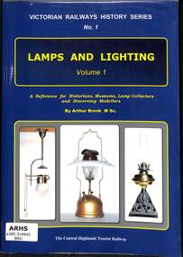
Book, Brook, Arthur, Victorian Railways History Series No. 1 Lamps and Lighting, 2019
Details and history of railway lamps and station lighting on the Victorian Railways.index, ill, p.202.non-fictionDetails and history of railway lamps and station lighting on the Victorian Railways.railroad infrastructure - victoria, railway lamps and lighting - victoria - history -
 Victorian Railway History Library
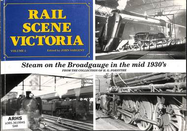
Book, Sargent, John, Rail Scene Victoria: Steam on the Broad gauge in the mid 1930s, 1992
A pictorial history of broad gauge 5'3" steam locomotives in Victoria in the 1930s in the area of North Melbourne, Newport, Flinders St & Spencer St stations. From the collection of H.G. Forsythe.ill, p80.non-fictionA pictorial history of broad gauge 5'3" steam locomotives in Victoria in the 1930s in the area of North Melbourne, Newport, Flinders St & Spencer St stations. From the collection of H.G. Forsythe.steam locomotives - victoria- history, railroad operations - victoria -
 Bacchus Marsh & District Historical Society
Map, Maddingley Township, Parish of Parwan, 1880s
This map is dated Sept. 6th 1856. However places in the township of Maddingley which did not appear until the late 1880s such as the Bacchus Marsh Railway Station and line are shown on this map in their correct locations. This suggests the map has been derived from an earlier map. An earlier date of 1843 with a surveyor's name preceding it can also be seen on the map. The map is important because it indicates the location and dimensions of early but now discontinued use of land such as the showgrounds and police paddock and a site reserved for the Church of England which was not ultimately used for a permanent church. A single page paper map showing land allotments, streets, rivers, creeks, park lands, the railway line and Bacchus Marsh railway station in the township of Maddingley. The map is pasted into a bound volume containing 76 maps or plans in total. Bottom of Map: Surveyor-General's Office, Melbourne, Sept 6th, 1856bacchus marsh victoria maps, maddingley victoria maps, land use, maddingley victoria history -
 Hymettus Cottage & Garden Ballarat
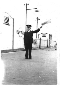
Photograph, Port Fairy Station
The photograph shows the station master Mr John (Jack) Taffe at Port Fairy, Victoria in the late 1950s signalling for the train to depart using flag and bell. The Port Fairy Railway station was closed twenty years later in 1977.port fairy, railway history, taffe, stationmaster, railway station closures, trains, train station. -
 Bacchus Marsh & District Historical Society
Map, Lerderderg Park Lands sale plan. 1911
This plan was for the sale of parcels of land from the Lerderderg Park Estate property in 1911. Advertising for the sale appeared in the Bacchus Marsh Express newspaper through July of 1911. The property was situated only a few kilometers from the township of Bacchus Marsh. The agents for the sale were L. A. Fairbairn & Co.Lerderderg Park Estate was a significant and early colonial property in the Bacchus Marsh area. This plan provides details about the first time the property was subdivided for sale. It is therefore documents an important moment in the history of this property and the broader trend of the subdivision of older and larger properties in the district.A single page paper plan showing allotments of land for sale from the Lerderderg Park property owned by John Wills. The parcels of land for sale are coloured in red.The Lerderderg River and Pyke's Creek Irigation Channel shown on the plan are in blue ink. The rest of the plan is a dark cream or beige colur with the text in black ink. The plan has been extensively annotated with hand-written notes indicating the names of people who purchased the various parcels of lands and the prices paid for those lands. Part of the top of the plan containing some text appears to be missing. The plan is pasted into a bound volume containing 76 maps or plans in total. Top: Have received instructions to Sell, account Mr John Wills, his renowned LERDERDERG PARK LANDS, so well and favourably known throughout the Commonwealth. In areas from 3 acres to 1276 acres. Every lot is either rich lucerne land (or portion now under lucerne) with some higher land adjoining Railway Station, and 2 Milk factories within 2 miles, absolutely the finest land in Victoria. Bottom: THIS IS THE FIRST SUBDIVISIONAL SALE of Rich Flats in Bacchus Marsh since the Pyke's Creek Scheme, and every lot is commanded by it. Only 32 miles from Melbourne.bacchus marsh victoria maps, land sales, lerderderg park estate, land subdivision -
 Victorian Railway History Library
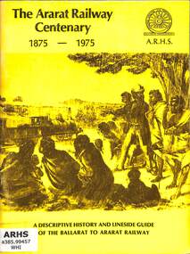
Book, Turton, Keith et al, The Ararat Railway Centenary 1875-1975, 1975
A history of the Ballarat to Ararat railway in western Victoria and a lineside guide to the stations on the line. The book was issued by the Australian Railway Historical Society, Victorian Division on the occasion of the Centenary Celebrations of the opening of the railway to Ararat on the 5th April 1875.ill, maps, p.60.non-fictionA history of the Ballarat to Ararat railway in western Victoria and a lineside guide to the stations on the line. The book was issued by the Australian Railway Historical Society, Victorian Division on the occasion of the Centenary Celebrations of the opening of the railway to Ararat on the 5th April 1875.railroad construction - victoria - history, railway services: ballarat-ararat railway. victoria. ararat region -
 Victorian Railway History Library
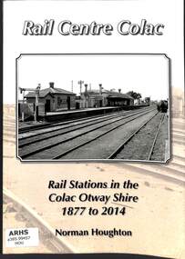
Book, Houghton, Norm, Rail Centre Colac, 2014
An history of the rail stations on the Victorian Railways lines in the Colac Otway Shire including the lines to Forrest, Alvie, Cressy and the 2'6" narrow gauge railway to Crowes.index, ill, maps, p.262.non-fictionAn history of the rail stations on the Victorian Railways lines in the Colac Otway Shire including the lines to Forrest, Alvie, Cressy and the 2'6" narrow gauge railway to Crowes.railroad construction - victoria - history, logging railroads - victoria - otway range - history -
 Bendigo Historical Society Inc.
Document - NOTES ON BENDIGO MINES
Handwritten notes on Bendigo Mines. Notes include area of lease, yards along the reef, depth, dividends, main shafts within one mile of Bendigo Station and shafts made safe by the Mines Dept. Mines mentioned are: South New Moon, Carlisle, Nth Garden Gully, Passby, Old Carlisle,Kentish, Central Garden Gully, Golden Fleece, Garden Gully United, Big Blue, Union Co, Red, White & Blue, New Chum Railway, Unity, Cornish, Catherine Reef United, Garden Gully United, Gt Extended Hustlers, Gt Northern, Lady Barkly, New Moon, South St Mungo, Virginia and Victoria Quartz, Document from Albert Richardson Collection of mining history.document, gold, notes on bendigo mines, notes on bendigo mines, south new moon, carlisle, nth garden gully, passby, old carlisle, kentish, central garden gully, golden fleece, garden gully united, big blue, union co, red, white & blue, new chum railway, unity, cornish, catherine reef united, garden gully united, gt extended hustlers, gt northern, lady barkly, new moon, south st mungo, virginia, victoria quartz, graham, tenby and ashman, mr j b watson, geo lansell, mines dept, d e thomas -
 Melbourne Tram Museum
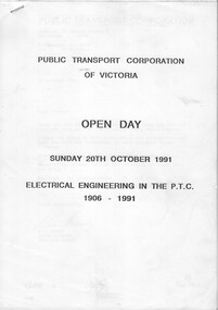
Document - Report, Public Transport Corporation (PTC), "Electrical Engineering in the PTC 1906 - 1991", Oct. 1991
Report or Programme for the Sunday 20th October 1991, PTC Open Day 23 A4 photocopied sheets + A3 folded drawing stapled in the top left hand corner titled "Electrical Engineering in the PTC 1906 - 1991". Describes the history of electric traction systems and engineering in Victoria for both rail and tram operations, overhead wiring systems, lighting and power supplies, with photos of Newport Power Station, Jolimont, Camberwell, Preston tramway substations. The last sheet has a drawing, poor quality of the 1500V DC railway traction system.trams, tramways, ptc, overhead, substation, electrical engineering, electric traction, open days -
 Bacchus Marsh & District Historical Society
Map, Maddingley Township, Parish of Parwan, circa 1890s
Maddingley is a locality or township within the broader township area of Bacchus Marsh. This map is not dated. However features in Maddingley which appeared in the 1880s and 1890s are present in the map, These include the Bacchus Marsh Railway Station and the Bacchus Marsh Showgrounds. The main residential and commercial area of Maddingley is shown on this map in an area bounded by Bacchus Street, Barry Street, Griffith Street and Maddingley Road. Other streets visible are Franklin Street, Inglis Street, Labilliere Street, McCrae Street, Moore Street and part of Station Street.A single page paper map showing land allotments, streets, rivers, creeks, park lands, the railway line and Bacchus Marsh railway station in the township of Maddingley. The map is pasted into a bound volume containing 76 maps or plans in total. bacchus marsh victoria maps, maddingley victoria maps, land use, maddingley victoria history -
![Map, Ballarat and Gordons Lane Plan of Land required [for railway line work]](/media/collectors/5e461d8021ea67224c82f2a1/items/676ff3a62c3783fe00b96a8d/item-media/676ff4a42c3783fe00b96cb6/item-fit-380x285.jpg) Bacchus Marsh & District Historical Society
Bacchus Marsh & District Historical SocietyMap, Ballarat and Gordons Lane Plan of Land required [for railway line work]
The railway line from Melbourne to Bacchus Marsh was completed in February 1887. After this date work continued to extend the line to Ballan. This map indicates a portion of land only a few hundred metres west of the Bacchus Marsh railway station which would have been among the first stages of the line to Ballan to have been constructed. This suggests the date of this map to be in the late 1880s.Single page map showing land required for railway line work near Griffith Street, Bacchus Marsh. Scale 10 chains to 1 inch. Hand-written on the map are the exact distances between Bacchus Marsh and Gordons (Gordon) and between Bacchus Marsh and Melbourne as measured from the corner of Maddingley Road and Station Street. Distances recorded are in miles, chains and links. The land required for the railway works is marked in red ink and runs through an area known as Kennedy's Gully. Part of a set of maps which are pasted into a bound volume containing 76 maps or plans in total. High resolution digital image stored on BMDHS computer network. bacchus marsh victoria history, maddingley victoria history, railway lines -
 Bendigo Historical Society Inc.
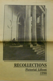
Newspaper - PETER ELLIS COLLECTION: RECOLLECTIONS PICTORIAL LIFTOUT
Historical lift out. Newspaper. Titled RECOLLECTIONS Pictorial Lift out 1990.1 looking down Mitchell St. from Railway Bridge. 2 Original railway station viewed from Mitchell St. bridge. 3 The great extended Hustlers mine. 4 1873 photo recently extended town hall with corn exchange at front left. 5 looking north westerly from city rec reserve at royal hustlers. 6 children play on mullock heap in front of a view of westerly quarter of Sandhurst. 7 Bank of Victoria, Mitchell St. left is Bendigo's original post office. 8 Looking down from what is now Rosalind Park. Shamrock Hotel can be seen on corner of Williamson St. and Pall Mall. This photo predates the construction of post office and law courts. 9 girl eating fairy floss. 10 4 kids on 1 horse in procession. 11 monkey and pedal car, a novelty attraction 1940's. 12 pony rides. 13 flying horses (ride). 14 processions past city hall. 15 Original ANZ bank corner Williamson St. & Pall Mall. 16 Chinese Dragons Bendigo Easter Fair 1940's. 17 City Hall viewed from Bull St. 18 City Hall original ceiling. 19 new town hall 1861. Mike Butcher, local historian. 21 Interior plan of city hall (ground floor) 22 circa 1920's 23 Tattered fragment original architect's drawing. 24 original assembly room. 25 Camp Hill PS Shamrock hotel without top story 27 shop with signage advertising Bushells, Bex and Swallow's Biscuits. 28 View from where fountain is now. 29 Hargreaves St. Looking south, now Hargreaves mall. Horse drawn water tank watering down road. 30 Central Deborah Gold mine poppet head. 31 Borough town hall, tram ways. 32 Original ANZ Bank corner Williamson St. and Pall Mall, demolished in mid 1960's. 33 Bush's store corner Williamson and Myer streets.34 Men on boat, don't know what or where. 35 Shearers. 36 men on a three wheeled bike. 37 4 Gold miners with shovels. 38 6pm closing, no trade Sundays, no women in main bar. 39 Peaceful scene Castlemaine 1940's Photographer Alan Doney. 40 Qantas Jet the City of Bendigo Tullamarine Airport. BCV-8 camera man & Advertiser photographer. 41 Ladies. 42 Tennis -> men and women (women in hats). 43 Sandhurst footy team. 44 Early school photos.bendigo, history, photographic history -
 Narre Warren and District Family History Group
Booklet, Narre Warren & District Family History Group Inc, Casey Cardinia Collection - Nar Nar Goon Information File, 2005
Nar Nar Goon, a town in Gippsland, Victoria, has a rich history dating back to the mid-19th century. Originally part of the Kulin nation, the area was home to the Boon Wurrung people. The name "Nar Nar Goon" is believed to come from a Boonwurrung word referring to either the koala or the rakali. European settlement began with the establishment of the Mount Ararat pastoral run in 1844, followed by land sales in the 1850s and 1860s. Many settlers came from Ireland, particularly from the Monteagle estate in Limerick. The arrival of the railway in 1881 was a turning point, facilitating timber and agricultural industries. Several sawmills operated in the area, transporting timber via wooden tramways to the railway station. By the early 20th century, Nar Nar Goon had developed into a thriving township with a general store, hotel, butcher, baker, and garage. The town had strong Catholic roots, with a church opening in 1905. Over time, timber milling declined, and dairy farming became the dominant industry. In 2021, part of Nar Nar Goon was annexed to form the new suburb of Pakenham East. Today, Nar Nar Goon is known for its murals, historical buildings, and community spirit. It remains a small but significant town in Victoria’s history. [AI generated text]Display book containing a table of contents and various newspaper clippings and other information pertaining to the Nar Nar Goon area.non-fictionnar nar goon (vic.), nar nar goon (vic.) -- history, bernie byrne, jack egan, mark & sylvia jones, daisy lia, bill doherty, michael o'brien, joan & frank lindsay, paddy henwood, bob rose, harry james, ray coombs, jack payroll, deb bramley, nar nar goon-maryknoll cricket club, john byrne, bernie dingle, jan van steensel, len & mary bramley, kylie shanks, bill bickerton, james dore, red gem potatoes, brydie cunningham -
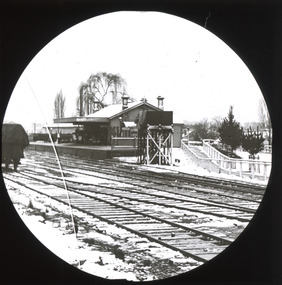 The Beechworth Burke Museum
Photograph - Lantern Slide, c1900
This slide shows an image taken in c.1900 of the Beechworth Railway Station. The Beechworth Railway Station was officially opened on the 29 of September 1876, to allow for quicker and easier transportation of goods and supplies from Beechworth to Melbourne via Everton and Wangaratta. The railway station was heavily used for transportation running two trains a day and was a vital link to Melbourne from it's opening until it's closure in 1976. Lantern slides, sometimes called 'magic lantern' slides, are glass plates on which an image has been secured for the purpose of projection. Glass slides were etched or hand-painted for this purpose from the Eighteenth Century but the process became more popular and accessible to the public with the development of photographic-emulsion slides used with a 'Magic Lantern' device in the mid-Nineteenth Century. Photographic lantern slides comprise a double-negative emulsion layer (forming a positive image) between thin glass plates that are bound together. A number of processes existed to form and bind the emulsion layer to the base plate, including the albumen, wet plate collodion, gelatine dry plate and Woodburytype techniques. Lantern slides and magic lantern technologies are seen as foundational precursors to the development of modern photography and film-making techniquesThis glass slide is significant because it provides insight into Beechworth's social amenities and religious infrastructure in the late Nineteenth Century. It is also an example of an early photographic and film-making technology in use in regional Victoria in the time period.Thin translucent sheet of glass with a circular image printed on the front and framed in a black backing. It is held together by metals strips to secure the edges of the slide.burke museum, beechworth, lantern slide, slide, glass slide, plate, burke museum collection, photograph, monochrome, beechworth railway station, railway station, transport, railway history, railway