Showing 364 items matching "reynolds road"
-
 Eltham District Historical Society Inc
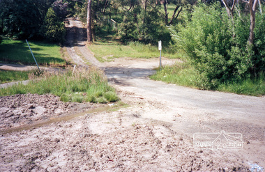
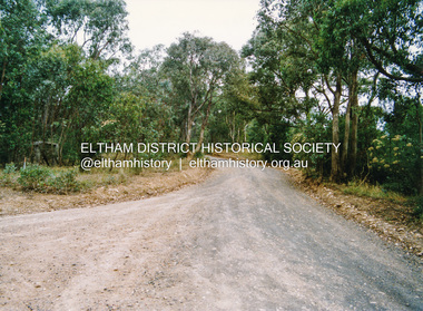
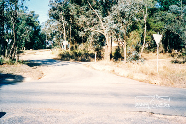
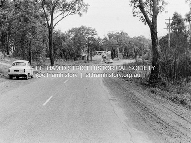
Photograph, Reynolds Road at intersection with Main Road, Research, c.April 1987
... Reynolds Road at intersection with Main Road, Research...reynolds road... melbourne shire of eltham roads main road reynolds road research ...Roll of 35mm colour negative film, 3 stripsKodak GA 100 5095shire of eltham, roads, main road, reynolds road, research (vic.) -
 Eltham District Historical Society Inc
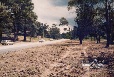
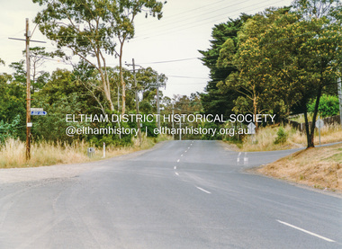
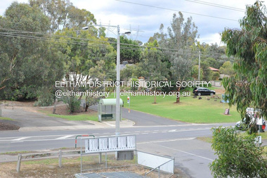
Photograph, Main Road between Bayfield Drive and Reynolds Road, Eltham, c. Oct 1987, 1987
... Main Road between Bayfield Drive and Reynolds Road, Eltham...reynolds road... infrastructure shire of eltham bayfield drive main road reynolds road ...Used in Shire of Eltham display at the Eltham Community Festival, 7 November 1987.Colour photograph mounted on green-painted chipboard with string on back for hangingdisplay panel, eltham festival, infrastructure, shire of eltham, bayfield drive, main road, reynolds road, streets -
 Eltham District Historical Society Inc
Photograph, Thompson Crescent area, Research
... reynolds road... area, Research 1. Reynolds Road looking south from Thompson... melbourne thompson crescent reynolds road research Three colour ...Three colour photographs of roads in the Thompson Crescent area, Research 1. Reynolds Road looking south from Thompson Crescent North 2. Reynolds Road/Thompson Crescent South 3. Reynolds Road/Thompson Crescent North, Researchthompson crescent, reynolds road, research -
 Eltham District Historical Society Inc
Slide - Photograph, Woodhaven Estate off Reynolds Road, Eltham, c.May 1988
... Woodhaven Estate off Reynolds Road, Eltham... Reynolds Rd. Melway ref 22.E.3 main road eltham housing estate ...The Age, Saturday, April 15, 1989, Page 72 OPEN SAT SUN 2-4 WOODHAVEN ESTATE A sample of house and land packages for your consideration: 3 br Ige rumpus $159,950 4 br tri level $169.9S0 4 br split level $169,500 Colonial with verandahs $199,950 Big 4 br dble garage $235,000 Huge exec 5 br S266.000 Meet our representative on site 2-4pm Sat and Sun in Booth Court, Eltham. off Reynolds Rd. Melway ref 22.E.335mm colour positive transparency (1 of 23) Mount - Kodak EktachromeProcess Date MAY 88Mmain road, eltham, housing estate, nicholas lauder real estate, woodhaven estate -
 Eltham District Historical Society Inc
Photograph, Doug Orford, Lorimer Road, Research, near Reynolds Road, 1991, 1991
... Lorimer Road, Research, near Reynolds Road, 1991... Road, Research, near Reynolds Road, 1991 Photograph Photograph ...From a collection of 35 photos taken by Doug Orford at 35 specific locations along the exact boundary of the then Shire of Eltham.Colour photographresearch (vic.), lorimer road -
 Eltham District Historical Society Inc
Photograph, Doug Orford, Kangaroo Ground - Wattle Glen Road, Wattle Glen, near Reynolds Road, 1991, 1991
... Reynolds Road, 1991... Reynolds Road, 1991 Photograph Photograph Doug Orford ...From a collection of 35 photos taken by Doug Orford at 35 specific locations along the exact boundary of the then Shire of Eltham.Colour photographkangaroo ground - wattle glen road, wattle glen -
 Eltham District Historical Society Inc
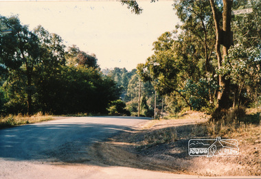
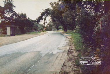
Photograph, Eltham-Yarra Glen Road, Reynolds Road to Kanandah Court
... Eltham-Yarra Glen Road, Reynolds Road to Kanandah Court... (string on back for hanging) Eltham-Yarra Glen Road, Reynolds Road ...One of a set of display images thought to be produced by the Shire of Eltham c.1979-1987Illustrative of services provided by former Shire of ElthamColour photograph 20 x 29 cm mounted on green-painted chipboard 28 x 35.5 cm (string on back for hanging)Title printed on label adhered to board below photograph (replaced June 2017)road, eltham -
 Eltham District Historical Society Inc
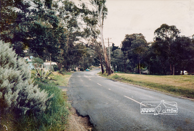
Photograph, Eltham-Yarra Glen Road, Reynolds Road to Kanandah Court
... Eltham-Yarra Glen Road, Reynolds Road to Kanandah Court... Glen Road, Reynolds Road to Kanandah Court Photograph ...One of a set of display images thought to be produced by the Shire of Eltham c.1979-1987Illustrative of services provided by former Shire of ElthamColour photograph 20 x 29 cm mounted on green-painted chipboard 28 x 35.5 cm (string on back for hanging)Title printed on label adhered to board below photograph (replaced June 2017)road, eltham-yarra glen road, eltham -
 Eltham District Historical Society Inc
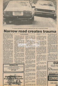
Newsclipping, Narrow road creates trauma by Jeni Downing, 1987c
... (Vic.), Reynolds Road...News report on dangerous conditions of Reynolds Road... melbourne News report on dangerous conditions of Reynolds Road Beryl ...News report on dangerous conditions of Reynolds RoadDigital file only - Digitised by EDHS from a scrapbook on loan from Beryl Bradbury (nee Stokes), daughter of Frank Stokes.beryl bradbury (nee stokes) collection, eltham, research (vic.), reynolds road -
 Eltham District Historical Society Inc
Photograph, Thompson Crescent area, Research
... reynolds road... area, Research 1. Norman Road/Keith Court 2. Reynolds Road... melbourne thompson crescent norman road keith court reynolds road ...Three colour photographs of roads in the Thompson Crescent area, Research 1. Norman Road/Keith Court 2. Reynolds Road/Thompson Crescent North and Nicholson Street 3. Thompson Crescent, Researchthompson crescent, norman road, keith court, reynolds road, nicholson street, research -
 Eltham District Historical Society Inc
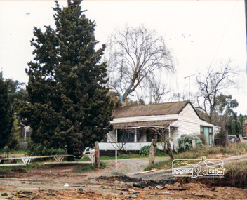
Photograph, Cottage, corner Main and Reynolds roads, Research, Vic, 1986
... reynolds road... and Reynolds roads at Research in 1986. The cottage was built... reynolds road Research (Vic.) Lyn Dodkins Wal Dodkins Bernie ...Wal and Bernie Dodkins, rented the house from Miss Reynolds probably from around 1938 until they left in the 1970s to become caretakers at the Kangaroo Ground Tower. Lyn Dodkins (wife of Graeme Hardiman) was born there and lived in this house for her first 19 years. [Graeme Hardiman email 5 Aug 2022]Six colour photographs of old cottage corner Main and Reynolds roads at Research in 1986. The cottage was built by/for Grandfather Reynolds and was demolished 2 Mar 1987. Three views show widening of Main Road.houses, main road, reynolds road, research (vic.), lyn dodkins, wal dodkins, bernie dodkins, miss reynolds -
 Eltham District Historical Society Inc
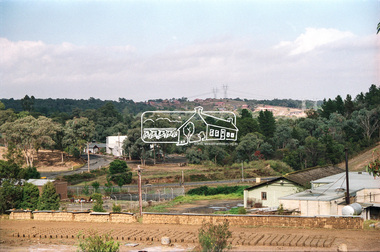
Negative - Photograph, View towards Main Road, Research from Maroondah Aqueduct Trail showing mudbrick manufacture, Research Industrial Estate, 1991
... Reynolds Road... estate development off Reynolds Road in distance... estate development off Reynolds Road in distance Eltham Little ...Eltham Little Theatre in centre distance and new housing estate development off Reynolds Road in distanceRoll of 35mm colour negative film, 9 strips Colour print 10 x 15 cmFuji HG 200 CA-1eltham little theatre, houses, main road, maroondah aqueduct, maroondah aqueduct trail, mudbrick, mudbrick construction, research (vic.), research industrial estate, reynolds road -
 Eltham District Historical Society Inc
Photograph, Barry Philp, Eltham-Yarra Glen Road, Research, Vic, c.1967
... Reynolds Road... intersection with Reynolds Road and Dodkins Second Hand Dealer store... intersection with Reynolds Road and Dodkins Second Hand Dealer store ...View looking south along Eltham-Yarra Glen Road towards intersection with Reynolds Road and Dodkins Second Hand Dealer store on corner, c.1967.In digital metadata "My beautiful picture"cars, eltham-yarra glen road, main road, research (vic.), reynolds road, dodkins family, second hand dealer store, second hand dealer -
 Eltham District Historical Society Inc
Photograph, Barry Philp, Entrance to Research Oval, Eltham Motor Inn opposite, Main Road, Eltham, c.2013
... Reynolds Road...Corner of Reynolds Road just out of sight to left. View... melbourne Corner of Reynolds Road just out of sight to left. View ...Corner of Reynolds Road just out of sight to left. View is comparable to EDHS_05762 showing the site of the original home of the Dodkins family now the Eltham Motor Inn.main road, research (vic.), eltham, eltham motor inn, research oval, reynolds road -
 Eltham District Historical Society Inc
Photograph - Aerial Photograph, Landata, Eltham, Vic, Apr. 1972
... Reynolds Road..., Reynolds Road to east and Bible Street to west. Historic Aerial..., Reynolds Road to east and Bible Street to west. Historic Aerial ...Centred on present day Mays Road at Stringybark Road, Eltham bounded by Nyora Road to north, Yarra River to south, Reynolds Road to east and Bible Street to west. Historic Aerial Imagery Source: Landata.vic.gov.au Aerial Photo Details: Project No :985 Project : MELBOURNE 1972 Run : 28 Frame : 209 Date : 04/1972 Film Type : B/W Camera : RC10 Flying Height : 5700 Scale : 9600 Film Number : 2635 GDA2020 : 37°43'33"S, 145°09'28"E MGA2020 : 337647, 5823013 (55) Melways : 22 B8 (ed. 42)aerial photo, neil webster collection, 1972-04, eltham, bible street, mays road, melway 22b8, nyora road, reynolds road, stringybark road, yarra river -
 Eltham District Historical Society Inc
Photograph, Liz Pidgeon, Heritage Excursion; East of Eltham, 6 Sep 2014, 20 May 2017
... reynolds road... extending from Eucalyptus Road to Reynolds Road at the eastern... extending from Eucalyptus Road to Reynolds Road at the eastern ...Newsletter No. 218, September 2014 September Excursion - East of Eltham Walk In Newsletter No. 197, March 2011, there was a brief history of Crown Allotment 15 Section 5 Parish of Nillumbik (CA 15) a parcel of land of a quarter of a square mile extending from Eucalyptus Road to Reynolds Road at the eastern extremity of Eltham. From the 1940s it was known as Stokes orchard. In later years it has been subdivided for residential purposes but leaving significant areas as power line and water supply reserves and bushland reserves that are habitat for the threatened For our excursion on 6th September we intend to walk through CA 15 to a bushland reserve east of Reynolds Road. The walk will traverse the boundary between suburban Eltham and the non-urban areas to the south and east. This is a pleasant walk through residential areas and bushland. Along the way we will discuss the early and more recent history of CA 15 as well as local natural history and geology. This walk is about 3.5 km in length and will take 2 to 2.5 hours. It will start at 2pm at the corner of Eucalyptus Road, Pitt Street and Nyora Road.Born Digitaleltham east, eltham district historical society, heritage excursion, activities, nyora road, reynolds road, gum tree road reserve, diosma road, stokes orchard, eucalyptus road -
 Eltham District Historical Society Inc
Photograph, Liz Pidgeon, Heritage Excursion; East of Eltham, 6 Sep 2014, 20 May 2017
... reynolds road... extending from Eucalyptus Road to Reynolds Road at the eastern... extending from Eucalyptus Road to Reynolds Road at the eastern ...Newsletter No. 218, September 2014 September Excursion - East of Eltham Walk In Newsletter No. 197, March 2011, there was a brief history of Crown Allotment 15 Section 5 Parish of Nillumbik (CA 15) a parcel of land of a quarter of a square mile extending from Eucalyptus Road to Reynolds Road at the eastern extremity of Eltham. From the 1940s it was known as Stokes orchard. In later years it has been subdivided for residential purposes but leaving significant areas as power line and water supply reserves and bushland reserves that are habitat for the threatened For our excursion on 6th September we intend to walk through CA 15 to a bushland reserve east of Reynolds Road. The walk will traverse the boundary between suburban Eltham and the non-urban areas to the south and east. This is a pleasant walk through residential areas and bushland. Along the way we will discuss the early and more recent history of CA 15 as well as local natural history and geology. This walk is about 3.5 km in length and will take 2 to 2.5 hours. It will start at 2pm at the corner of Eucalyptus Road, Pitt Street and Nyora Road.Born Digitaleltham east, eltham district historical society, heritage excursion, activities, nyora road, reynolds road, gum tree road reserve, diosma road, stokes orchard, eucalyptus road