Showing 92 items
matching ron west
-
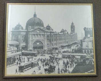 Melbourne Tram Museum
Print - Framed Print, Glen Waverley Picture Framing, 1970's?
Framed, glazed, black and white photograph of the intersection of Flinders and Swanston St Melbourne, looking towards Flinders St railway station. Timber frame, painted brown and gold, with brown paper lining on rear. Has brown string stapled at rear on both sides for hanging. In the central bottom of the rear is "Glen Waverley Picture Framing, sticker, 698 High St Road, Glen Waverley with a 7 digit phone number. Photo c1926?? features a very busy intersection cable trams (No. 17 west bound in Flinders, tram 160 north bound in Swanston, two W class trams, other cable trams, many motor cars, horse drawn vehicles, cyclist and pedestrians. Note the standing zone in Flinders St. In photo are Young and Jacksons Hotel, Bacchus Marsh Concentrated Milk table cream, and numerous signs on the railway station. See Reg Item 5272 for the photo on a Greetings Card and 5217 for a photographic print.on rear top "Donated to Hawthorn Tram Museum Feb 1912 Ron Scholten" in ink.trams, tramways, flinders st station, swanston st, flinders st, melbourne, cable trams -
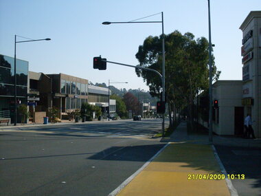
 Ringwood and District Historical Society
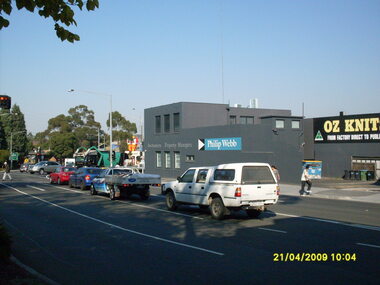
Photograph, Corner of Maroondah Highway and Ringwood Street looking south, Ringwood on 21 April 2009. Ozknit and Phillip Webb Real Estate on west side of road
Ron Brons photographic study of Ringwood -
 Ringwood and District Historical Society
Photograph, Corner of Seymour and Ringwood Streets looking west, Ringwood on 21 April 2009. Showing Staley Gardens in centre
Ron Brons photographic study of Ringwood -
 Ringwood and District Historical Society
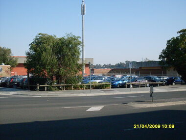
Photograph, Corner of Seymour and Ringwood Streets looking west, Ringwood on 21 April 2009. Showing former location of Ringwood Telephone Exchange, now a car park
Ron Brons photographic study of Ringwood -
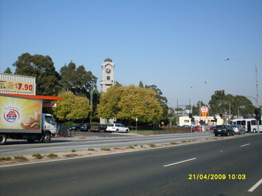 Ringwood and District Historical Society
Photograph, Corner of Maroondah Highway and Wantirna Road looking south-west, Ringwood on 21 April 2009. Memorial Clocktower, Haymes Paint and Johnny Boys Pizza
Ron Brons photographic study of Ringwood -
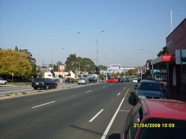 Ringwood and District Historical Society
Photograph, Corner of Maroondah Highway and Wantirna Road looking west, Ringwood on 21 April 2009
Ron Brons photographic study of Ringwood -
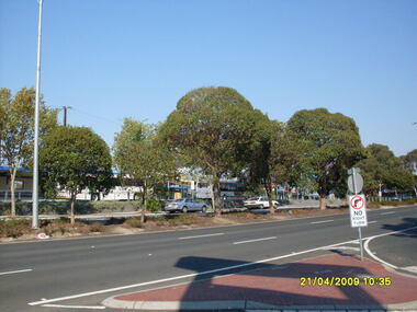
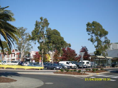
 Ringwood and District Historical Society
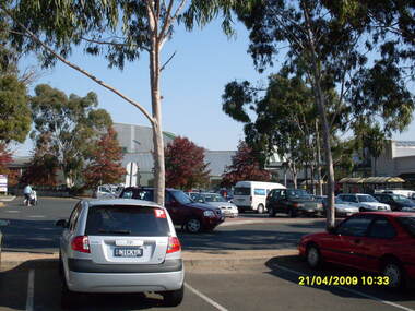
Photograph, Looking across stage 4 Eastland carpark, towards the south-west, on 21 April 2009. Showing strip of shops opposite the Ringwood Station
Ron Brons photographic study of Ringwood. -
 Ringwood and District Historical Society
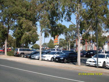
Photograph, Looking across stage 4 Eastland carpark, towards the north-west, on 21 April 2009. Showing the car park entrance and front Eastland shops
Ron Brons photographic study of Ringwood. -
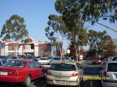
 Ringwood and District Historical Society
Photograph, Looking across stage 4 Eastland carpark, towards the west, on 21 April 2009. Showing the former Ringwood Library
Ron Brons photographic study of Ringwood. -
 Ringwood and District Historical Society
Photograph, Looking across stage 4 Eastland carpark, towards the south-west, on 21 April 2009. Showing Ringwood Railway Station across Maroondah Highway
Ron Brons photographic study of Ringwood. -
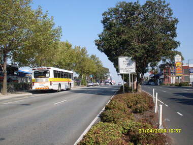
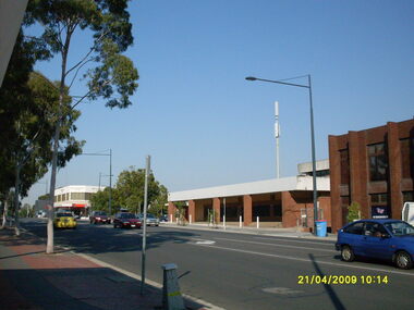
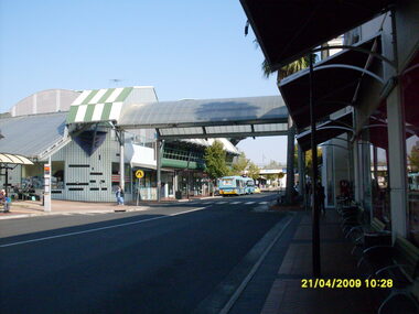
 Ringwood and District Historical Society
Photograph, Looking west along Maroondah Highway with Ringwood Railway Station on left and shops on right, on 21 April 2009
Ron Brons photographic study of Ringwood. -
 Ringwood and District Historical Society
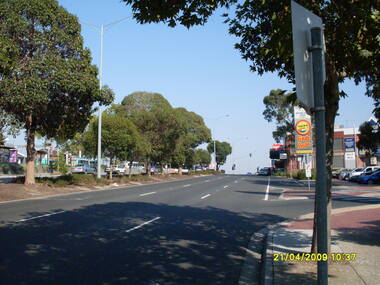
Photograph, Looking south south-west on Maroondah Highway, on 21 April 2009, showing bus terminus entrance
Ron Brons photographic study of Ringwood. -
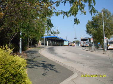 Ringwood and District Historical Society
Photograph, Looking south south-west on Maroondah Highway, on 21 April 2009, showing bus terminus entrance
Ron Brons photographic study of Ringwood. -
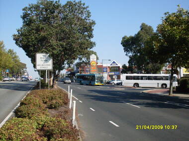
 Ringwood and District Historical Society
Photograph, Looking west along Maroondah Highway with Ringwood Railway Station and bus terminus on left and entrance to Eastland car park and shops on right, on 21 April 2009
Ron Brons photographic study of Ringwood. -
 Ringwood and District Historical Society
Photograph, Looking west along Maroondah Highway with Ringwood Railway Station on left and entrance to Eastland car park and shops on right, on 21 April 2009
Ron Brons photographic study of Ringwood. -
 Ringwood and District Historical Society
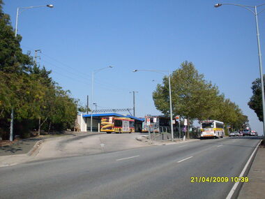
Photograph, Looking across Maroondah Highway towards the south-west, on 21 April 2009. Showing entrance to Ringwood bus terminus
Ron Brons photographic study of Ringwood. -
 Ringwood and District Historical Society
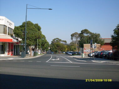
Photograph, Ringwood Street looking south-west, Ringwood on 21 April 2009. Former Post Office on right
Ron Brons photographic study of Ringwood -
 Kew Historical Society Inc
Biographical information, Ronald Horace Setford (1915–1988)
Ronald Horace Setford was born in April 1915 at 18 Church Street, Hawthorn, at his family’s home above their decorator shop. He was the second of three sons born to Horace Turner Setford (1880-1944) and Mabel Crofts (1887-1943). He attended Hawthorn West Primary School and then Swinburne before beginning work in his family’s business ‘Setford and Son’ in October 1930. This was formalised in April 1931 when he became a carpentry and joinery apprentice. In 1934 he graduated as a grade four carpenter. Ron worked in the family business until 1964 and then worked at J S Kidd and Co Pty Ltd as a storeman until his retirement in December 1973. Ron married Grace Muriel Agnes Perrey (1915-2001) in 1936 and they first lived in Kew around 1940, at 38 Marshall Avenue. Ron served in the Citizen Military Forces as a sapper with the 9 Australian Army Transport Company, Royal Australian Engineers, signing up a week after Darwin had been bombed. He spent time in Darwin, Wayville (South Australia), Herberton and Grovely (Queensland). Afterwards he refused to eat rice, never spoke of the war, nor took part in any ANZAC day proceedings. In 1941, Ron and Grace bought their block of land at 9 Tanner Avenue, East Kew, part of the Old Golf Links Estate, for £225. It was not until December 1945 that Ron started building their home and they moved in during May 1947. Ron and Grace remained there for thirty-seven years until the house was sold to their nephew in 1984. It has since been demolished. Ron’s great passion was photography and in the early 1960s he purchased his Minolta camera. Slide evenings at Tanner Avenue were a regular occurrence. Ron made his own title slides, interval slides and end slides. As well as many holiday photos (around Australia and their world trip in 1966), he enjoyed photographing local landmarks, flowers, insects and family. One of Ron’s photography projects was to record the progress of the building of the Eastern Freeway. This was near their home, and he’d walk down to the works on a regular basis, dressed smartly, with his camera in hand. The workers thought he was an official photographer, and he was allowed on site to take his photos. In 1984, Ron and Grace downsized and moved to Bayswater. Ron passed away on 31 October 1988 at the Maroondah Hospital in Ringwood East, at age 73. His ashes were spread on his beloved rose bushes at Tanner Avenue. Lauren Thomson, 2025ron setford, 9 tanner avenue -- kew east (vic, setford and son -- 18 church st (hawthorn), grace muriel agnes perrey, 9 australian army transport company, j s kidd and co pty ltd, eastern freeway, f19 freeway -
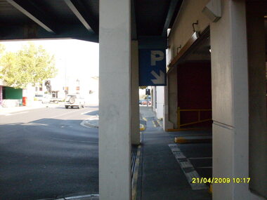 Ringwood and District Historical Society
Photograph, Carpark exit from Eastland looking west towards Ringwood Street. Ringwood on 21 April 2009
Ron Brons photographic study of Ringwood. -
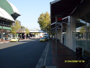
 Ringwood and District Historical Society
Photograph, Taken from Eastland access road looking south-west, on 21 April 2009. Showing library and pedestrian walk and crossing
Ron Brons photographic study of Ringwood. -
 Ringwood and District Historical Society
Photograph, Ringwood Street looking north-west, Ringwood on 21 April 2009. Police Station on left
Ron Brons photographic study of Ringwood -
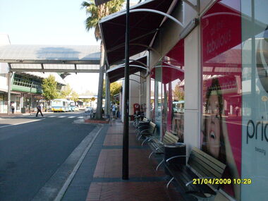
 Ringwood and District Historical Society
Photograph, Eastland access road looking west, on 21 April 2009. Showing library on left, shops on right and car overpass. Also Ventura buses and pedestrian crossing to Eastland
Ron Brons photographic study of Ringwood. -
 Ringwood and District Historical Society
Photograph, Eastland access road looking west, on 21 April 2009. Showing library on left, shops on right and car overpass
Ron Brons photographic study of Ringwood. -
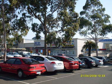
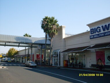 Ringwood and District Historical Society
Photograph, Looking along Eastland access road looking west, on 21 April 2009. Showing entrance to Eastland, cafe and Big W store
Ron Brons photographic study of Ringwood. -
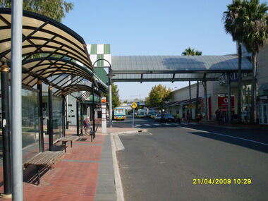 Ringwood and District Historical Society
Photograph, Looking along Eastland access road looking west, on 21 April 2009. Showing bus stop and entrance to Eastland
Ron Brons photographic study of Ringwood. -
 Ringwood and District Historical Society
Photograph, Looking along Eastland access road looking west, on 21 April 2009. Showing pedestrian crossing
Ron Brons photographic study of Ringwood. -
 Ringwood and District Historical Society
Photograph, Looking along Eastland access road towards the south-west, on 21 April 2009. Showing pedestrian crossing to south car park and shops
Ron Brons photographic study of Ringwood. -
 Ringwood and District Historical Society
Photograph, Looking along Eastland access road towards the west, on 21 April 2009. Showing pedestrian crossing to south car park
Ron Brons photographic study of Ringwood. -
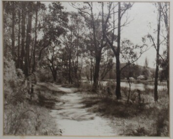 Ringwood and District Historical Society
Photograph, Kenneth Marshall, Ringwood Lake around 1960, path on west side, circa 1960
Framed silver gelatin printNotation on back - "Ken Marshall, Jeweller, Maroondah Highway Ringwood took this photo. It was displayed in his shop window when I bought it. The shop was next door to Pratt, the butcher, and Ron Dickson, fruiterer, just prior to the Eastland development - [from] Gloria Welch, 23 Campbell St. Ringwood East." -
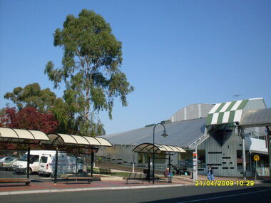
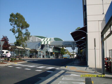
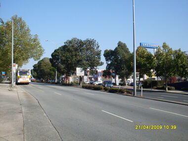 Ringwood and District Historical Society
Photograph, West along Maroondah Highway, on 21 April 2009, showing Eastland sign and shops opposite the railway station
Ron Brons photographic study of Ringwood.