Showing 216 items
matching rural landscape
-
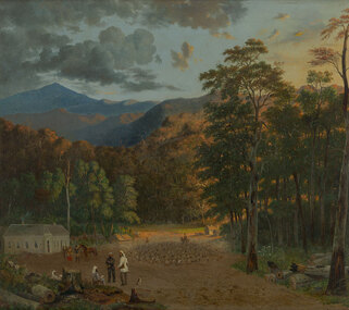
 Benalla Art Gallery
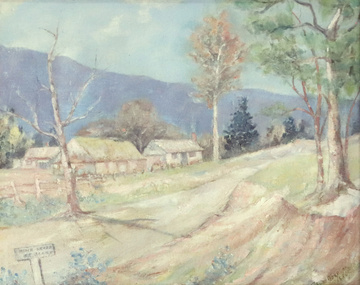
Painting, John Ford PATERSON, Miner’s cottage, 1884
... Oil on canvas on composition board, depicting a rural... Landscape House Trees Path Road Recto: Signed and dated “J FORD ...Born: Dundee, Forfarshire,Scotland 1851; Arrived: Melbourne, Victoria, Australia 1872; Lived and worked: Scotland 1875-1884; Died: Carlton, Victoria, Australia 1912VictorianLedger Bequest, 1993Oil on canvas on composition board, depicting a rural landscape and miner's commune off a dirt road. Gold brushed timber frame with decorative gesso edges and corners Recto: Signed and dated “J FORD PATERSON / 1884” in blue oil in l.r.c of composition; Not titledpainting, landscape, house, trees, path, road -
 Wangaratta Art Gallery
Painting, Ailsa Seargent, The Junction, 1969
... A rural river landscape painted in blues, greens and browns.... river A rural river landscape painted in blues, greens ...Rural City of Wangaratta Collection.A rural river landscape painted in blues, greens and browns.wangaratta art gallery, ailsa seargent, painting, landscape, river -
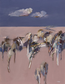
 Benalla Art Gallery
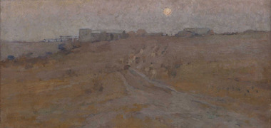
Painting, E. Phillips FOX, Evening (Charterisville hillside, Ivanhoe), c. 1894
... Rural night landscape with road, buildings and moon. Gold...; Not titled Rural night landscape with road, buildings and moon. Gold ...Born: Fitzroy, Victoria, Australia 1865; Died: 1915ImpressionismGift of Dr Robert W. Henderson 2004Rural night landscape with road, buildings and moon. Gold painted wooden frame.Recto: Signed "E Phillips Fox" in brown paint l.l.c of composition; Not dated; Not titledlandscape, evening, moon rising, rural, road, australian art -
 Orbost & District Historical Society
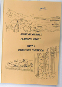
book / document, Shire of Orbost Planning Schemes March 1989, 1989
... and plastic binding.On the cover are b/w drawings of rural landscapes... are b/w drawings of rural landscapes, trees and the coast ...This document was produced in 1989 for Orbost Shire Council. It ccovers the area s of Orbost, Mallacoota, Cann River and Newmerella and includes urban and non-urban areas.This document is a useful reference tool.A book with a brown front cover with a plastic over-sheet and plastic binding.On the cover are b/w drawings of rural landscapes, trees and the coast. It is titled SHIRE OF ORBOST PLANNING STUDY Part 1 Strategic Overviews, March 1989.orbost-planning -
Glenelg Shire Council Cultural Collection
Photograph - Photograph - rural scene, Glenelg Shire, n.d
... Cliff Street Portland great-ocean-road photography rural scene ...Coloured photograph of a road, car in foreground, trees and houses on sides of road - unidentifiedphotography, rural scene, landscape -
 Bayside Gallery - Bayside City Council Art & Heritage Collection
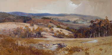
Painting - oil on board, Kevin Taylor, Summer near Licola, Gippsland
... Kevin Taylor Summer Licola Gippsland Victoria Rural Hills ...kevin taylor, summer, licola, gippsland, victoria, rural, hills, landscape, trees -
 Greensborough Historical Society
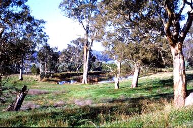
Slide - Photograph, John Ramsdale, Farmland Yallambie: Slide 49, 1990s
... Photograph shows a rural landscape with gum trees and dam... Plenty Lower Plenty melbourne Photograph shows a rural landscape ...Photograph shows a rural landscape with gum trees and dam; this is near Yallambie on the Plenty River.Part of the John Ramsdale collection of slides and audio visual material.Colour photograph scanned from slide.No maker's marks. No caption on slide.plenty river, yallambie -
 Benalla Art Gallery
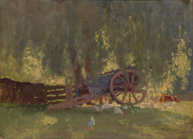
Painting, Elioth GRUNER, Summer shade, c. 1916
... Rural farm landscape with wagon, animals and building. Gold... of composition; Not dated; Not titled Rural farm landscape with wagon ...Born: Gisborne, New Zealand 1882; Arrived: Sydney, New South Wales, Australia 1883; Died: Sydney, New South Wales, Australia 1939Heidelberg SchoolGift of Mrs E.E. Ledger, 1975Rural farm landscape with wagon, animals and building. Gold patterned moulding with grey velvet insert frame.Recto: Signed "E. GRUNER" in black paint in l.r.c of composition; Not dated; Not titledpainting, rural, wagon, chicken, animals, wheel, fence, trees, farm, australian art -
 Greensborough Historical Society
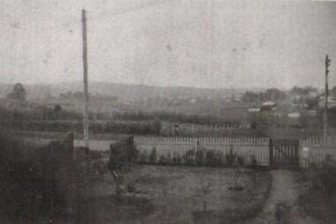
Photograph - Digital Image, Greensborough from 9 William Street, 1935c
... Photograph of Greensborough showing a rural landscape... a rural landscape as the backdrop to a neat fenced garden. Taken ...Photograph of Greensborough showing a rural landscape as the backdrop to a neat fenced garden. Taken from the Godwill home in William Street.Early photograph of rural GreensboroughDigital copy of black and white photograph.greensborough, william street greensborough, ray godwill -
 City of Kingston
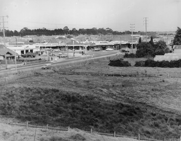
Photograph - Black and white, c. 1963
... urbanisation and the rural landscape that once made up the area now... urbanisation and the rural landscape that once made up the area now ...This image depicts the intersection of increasing urbanisation and the rural landscape that once made up the area now known as City of Kingston.Black and white photograph of the intersection of Warrigal Road and Centre Road, South Oakleigh, viewed from the reservoir. In the foreground are paddocks and in the background is a shopping strip, including a petrol station.Handwritten in blue ink on reverse: 2196 Handwritten in red ink on reverse: 100%oakleigh, roads, shopping strip, paddocks -
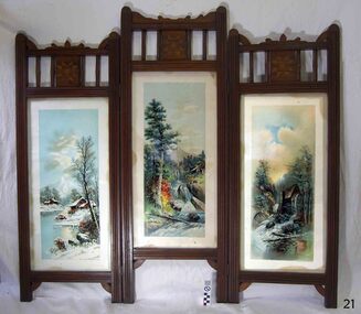 Flagstaff Hill Maritime Museum and Village
Furniture - Screen, Thomas Hope, 1905-1913
... depicting a rural landscape. Ornate stencil cut wood edging.... Each panel contains a glass-encased print depicting a rural ...The fire screen was part of the original furnishings of the Lighthouse Keeper's Quarters in Merri Street, Warrnambool. It was made by Lighthouse Keeper, Thomas Hope. Thomas served two terms as an assistant lighthouse keeper in Warrnambool. His first term was from 1905 to 1907. He later returned from 1910 to 1913, when he was appointed as Keeper five months after the untimely death of his predecessor Peter Quinn. Woodworking was one of Thomas Hope’s hobbies, and the three-panel fire screen he made as a lighthouse keeper is now in the Flagstaff collection and is displayed in the Lighthouse Keeper’s Cottage. Thomas Hope 1857 - 1928 Thomas James Hope was born in Camden, Surrey, England in 1857. His father, also called Thomas, was reputed to be a member of the Royal Family, and Thomas Hope Junior his illegitimate son. Thomas was subsequently brought up on the estate of the Earl of Hopetoun in Somerset and it was thought that Thomas was the Earl’s grandson. Against the wishes of those in charge of Thomas, he joined the navy at an early age, seeing much of the world until he settled in New Zealand at the age of twenty-four. After some years in New Zealand, he came to Australia to live. One of the jobs Thomas Hope had prior to becoming an assistant lighthouse keeper in 1896 was as a cook in the Lunatic Asylum at Sunbury, Victoria. He served as an assistant keeper at Shortlands Bluff, Gabo Island, Split Point and Warrnambool, retiring in 1918. He bought a house in Nicholson St, Warrnambool and died in March 1928. He is buried in the Warrnambool cemetery. Thomas Hope is recorded in family history as being of short stature and, not surprisingly given his alleged aristocratic connections, possessed a beautiful speaking voice. He and his wife Elizabeth nee Waters, whom he married in New Zealand, had six children (Thomas, killed in World War One), Ellen (Nell), Nora (who was married at the Warrnambool lighthouse keepers cottage), William (who died in Warrnambool), Marion and Alan. Joseph Hoover (Dec 29, 1830, to Aug 7, 1913) Joseph Hoover, the printer of the pictures on the screen, was born in Baltimore, of Swiss-German heritage. He was trained as an architectural woodturner. In 1856 Hoover moved to Philadelphia and began producing elaborate wooden frames in his wood-turning and framing business. By 1865 Hoover had started to produce popular prints for publishers and artists, which included noted Philadelphia artist James F. Queen. In the 1880s Hoover set up a complete plant specialising in chromatography, the process of producing colour prints from lithographic plates. The coloured prints he produced were affordable to business and private customers. In 1893 his son Henry L., a trained lithographer, joined the company as overseer and it was called J. Hoover & Son. It became one of the largest in America by the turn of the century. Hoover won a medal for Excellence for his Chromolithographs of James Queen’s works. In 1904 Joseph’s other son, Joseph W, joined the business as a partner and the company was called Jos. Hoover & Sons. Hoover died of a heart attack in 1913. He was survived by his wife and six children: two sons who were also his business partners, and four daughters. The firm continued in production until around 1985. Hoover’s prints included scenes, still life and landscapes of America and other locations. They were sold in America and overseas to countries including Canada, Germany, Mexico and England. The three-panelled screen in the Lighthouse Keeper’s Cottage was made by the Assistant Lighthouse Keeper, Thomas Hope during one of his two terms at the Lighthouse Keepers' Quarters. It is the only object in the collection known to be connected to Hope. The Lighthouse Keeper's Cottage is part of the Lady Bay Lighthouse Complex, which is listed on the Victorian Heritage Register for being of historical, scientific (technological) and architectural significance to the State of Victoria.Fire screen comprising three black wood framed panels hinged together. Each panel contains a glass-encased print depicting a rural landscape. Ornate stencil cut wood edging and quilt-inspired parquetry sits above each panel. The central panel is taller than those either side. Screen is lined in black-painted cardboard.Printed at the base of each of the three prints “COPYRIGHT 1896 BY J. HOOVER & SON, PHILAD’’A.”flagstaff hill, warrnambool, shipwrecked coast, flagstaff hill maritime museum, firescreen, thomas hope junior, ellen (nell) hope, nora hope, william hope, marion hope, alan hope, jos. hoover & sons of philadelphia, lighthouse keeper, assistant lighthouse keeper, carved screen, merri street, lighthouse keeper's cottage, lighthouse residence, lighthouse, wood carving, lighthouse complex, lady bay lighthouse, fire screen -
Glenelg Shire Council Cultural Collection
Slide - Slide - Cashmore Airport, Portland, 1980s
... construction site Cashmore Airport engineering landscape rural Coloured ...Coloured slide. View of worksite, body of water in foreground; Earth moving equipment further back, then cattle and low hills at rear.portland airport, construction site, cashmore airport, engineering, landscape, rural -
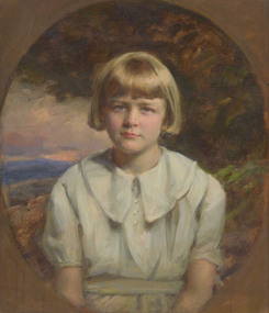 Benalla Art Gallery
Painting, John LONGSTAFF, Portrait of Elizabeth Coles c. 1934, c. 1935
... Garden Landscape Rural Australian art Recto: Signed and dated “J ...Born: Clunes, Victoria, 1861; Died: Melbourne 1941InterwarGift of Mrs Irwin Bright, 1992Figure depicting female child in blue dress in front of landscape image. Gold gesso painted frame. Recto: Signed and dated “J Longstaff 1934” in ochre paint m.r. edge of composition; Not titledportrait, child, garden, landscape, rural, australian art -
 Wangaratta Art Gallery
Painting, Len Pawluk, Afternoon Walhalla, 1981
... A aerial landscape of a rural road, painted in oil using...-country wangaratta art gallery len pawluk landscape rural painting ...Rural City of Wangaratta Collection, Wangaratta Art Prize Grand Winner 1981.A aerial landscape of a rural road, painted in oil using a colour palette of blue, green, white, yellow, and brown.Obverse: L Pawluk/ (bottom left corner)wangaratta art gallery, len pawluk, landscape, rural, painting, walhalla -
 Ballarat Heritage Services
Digital Photograph, L.J. Gervasoni, Melting Snow Newlyn, 2006
... agriculture landscape rural Digital Photograph od snow on a distant ...Digital Photograph od snow on a distant hill at Newlyn.snow, weather, victoria, newlyn, hepburn shire, agriculture, landscape, rural -
 Bayside Gallery - Bayside City Council Art & Heritage Collection
Painting - oil on canvas, Ulrich Stalph, Autumn at Clunes, 1980
... landscape rural trees ulrich stalph beaumaris art group inez ...Acquired by the Sandringham City Council in 1981 as winner of the acquisitive Inez Hutchison Award, established by the Beaumaris Art Group in 1966. Lenton Parr was the judge.Ulrich Stalph, Autumn at Clunes 1980, oil on canvas, 135 x 100.5 cm. Bayside City Council Art and Heritage Collection. Winner of the Inez Hutchison Award, 1981.clunes, autumn, landscape, rural, trees, ulrich stalph, beaumaris art group, inez hutchison award -
 Benalla Art Gallery
Painting, H. L. VAN DEN HOUTEN, Marysville Courthouse, Not dated
... Rural colonial forested landscape with animals, figures... Landscape Trees Figures Animals Buildings Mountains Colonial Horse ...Born: The Hague, Netherlands 1801; Arrived: Melbourne, Victoria, Australia 1853; Died: Melbourne, Victoria, Australia 1879VictorianGift of Wooleen Pty. Ltd., 1980Rural colonial forested landscape with animals, figures trees and mountains. Gold brushed timber frame.Recto: Signed "H.L.V.d.Houten / [illegible]" in brown oil in l.r.c of composition; Not dated; Not titledpainting, landscape, trees, figures, animals, buildings, mountains, colonial, horse, dog -
 Kiewa Valley Historical Society
Photograph of Kiewa Valley Panorama, Farming lands within the Kiewa Valley in1950s, Circa 1950
... ) when this remote valley was part of a "lay back" rural... was part of a "lay back" rural landscape,occasionally visited ...This photograph shows how (early to mid1900s), before the establishment of the Mount Beauty "gated" village, the Kiewa Valley was farmed and the scarce population was spread out over acres of productive land. This photograph catches a time before (what appeared to the local farmers as the invasion by a mass of construction workers) when this remote valley was part of a "lay back" rural landscape,occasionally visited by friends and some wayward tourists. The mountain ranges provided an adequate barrier against the way-would traveller. The immigration numbers coming into Australia was still quite small ( due to the "white" Australia policy) which was in force before World War II. After World War II a mass of displaced European refugees and migrants boosted the Australian population and provided for a greater degree of diverse professions and rural related work force.This photograph depicts the borderline in time between an exclusively rural based population and respective activities(early 1900s)to the present (2000 on wards) integrated village, tourist and retiree/holiday area. The time when land was exclusively used in agriculture is over and the impact of cheaper rural produce from Asian markets will see a shift of land useage and population activities. The Kiewa Valley is loosing its hiding place and is becoming more and more a source of untapped residential land. Black and white photograph of farming/grazing land useage, before the establishment of the Mount Beauty Village. Small pockets of residentual houses can be viewed. Road access (unsealed dirt) was typical of that provided in rural regions in the 1950s. The photo is on 200gms paper and not on photographic paper.kiewa valley in the early1900s, grazing in the kiewa valley, sec victoria -
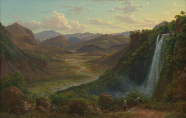 Benalla Art Gallery
Painting, Eugene VON GUERARD, The fall of the Veliono near Terni with the view up the Valley of the River Nera, 1885
... Rural valley and mountain landscape with two figures... Landscape River Cliff Mountain Figures Buildings Waterfall Sky ...Born: Vienna, Austria 1811; Arrived: Melbourne, Victoria, Australia 1852; Died: London, Middlesex England 1901RomanticismLedger Gift, 1984Rural valley and mountain landscape with two figures walking down a track beside a waterfall towards a river. Gold brushed gesso decorative edged timber frame.Recto: Signed and dated "Eug.V.Guérard / D. 85" in red oil in l.r.c of composition; Not titledpainting, landscape, river, cliff, mountain, figures, buildings, waterfall, sky, clouds -
 Kiewa Valley Historical Society
Photograph of Snow Covered Catchment Area Vic, Snow Covered Catchment Area Victorian Alps - 1950s, Circa 1950
... " rural landscape,occasionally visited by recreational adventurers... when this remote area was part of a "lay back" rural landscape ...This photograph details (early to mid1950s), the Victorian Alpine region when this remote area was part of a "lay back" rural landscape,occasionally visited by recreational adventurers and some wayward tourists. The mountain ranges had provided an adequate barrier against the way-would traveller, but with the opening up of this region by the provision of improved roadways and accommodation facilities, courtesy of the Kiewa Valley Hydro Electricity Scheme, changes such as tourism and its impact upon the "natural" state started to show its side effects (clearing of the land). The expansion of the European immigration numbers (1950s) coming into Australia was increasing after World War II which not only provided increased construction workers to the region but also immigrants who appreciated alpine regions. Some of these immigrants contributed to the expansion of the region and provided for a greater degree of diverse professions and rural related work force.This photograph depicts the borderline in time between an exclusively rural based population and respective activities(early 1900s)to the present (2000 on wards) integrated village, tourist and retiree/holiday area. The time when land was exclusively used in agriculture and Alpine grazing lands is over. The Kiewa Valley is loosing its hiding place and is becoming more and more a source of untapped residential land and winter time recreational adventure lands. The changes brought about by modern technologies involving recreational activities such as hang gliding, gliding (local airstrip), mountain bikes, car rallies and their associated clubs is providing for an increased short term population boost. These together with the attractions for retirees is changing not only the physical nature of the Kiewa valley but also its "soul".This item is a black and white photograph of a section of snow covered catchment area in the Victorian Alps in the mid 1900. It is on 200 gms paper but not on photographic paper and has a white boarder (3 mm).kiewa valley tourism, victorian alps, alternate energy supplies, alpine population growth -
 Eltham District Historical Society Inc
Slide - Photograph, On the Eltham Road, Walter Withers (1906), Heidelberg School Artists Trail, Alistair Knox Park, Eltham, c.Nov. 2001
... : "In this cheerful rural landscape, Walter Withers has captured the spirit...: "In this cheerful rural landscape, Walter Withers has captured the spirit ...The Heidelberg School Artists Trail was established in about 1999 with about 52 signs across four local governemnt areas including Nillumbik and Banyule. It extends from Heidelberg through Eltham and Warrandyte and to the Dandenongs. It features signs depicting paintings of artists in the location in which they were painted. This one acknowledges "On the Eltham Road", 1906. Transcription of the text states: "In this cheerful rural landscape, Walter Withers has captured the spirit of early Eltham. Eltham was a quiet, sleepy village, where geese wandered up the main Road and the locals either walked or rode their horses or bicycles around the township. Walter Withers was known to load up his bicycle with his collapsible easel, folding stool, paint box, water bottle and canvases, and would head off for a day’s painting. He was also known for his walking, as was his family, and they became known as the ‘Walking Withers’ Part of a slide show presentation "A Trip Down the Diamond Creek" by Russell Yeoman to the Eltham District Historical Society meeting of 14 Nov. 200135mm colour positive transparency Mount - Black and Whiteeltham, alistair knox park, heidelberg school artists trail, on the eltham road, public art, sign, walter withers -
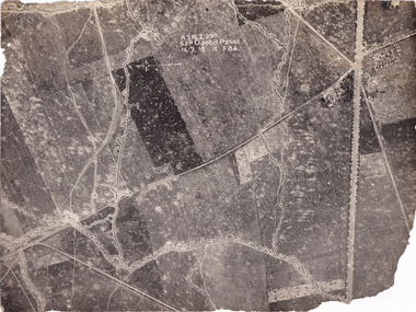 The Beechworth Burke Museum
Photograph
... an aerial view of trenches in France. The image mostly shows rural... an aerial view of trenches in France. The image mostly shows rural ...Taken some time between 1914-18, the photograph depicts an aerial view of trenches in France. The image mostly shows rural landscape, although there is a cluster of houses in the top right corner. It is believed that this record denotes a section of the Western Front. The Western Front was the main theatre of war during World War I. Following the outbreak of war in August 1914, the German Army opened the Western Front by invading Luxembourg and Belgium, then gaining military control of important industrial regions in France. The German advance was halted with the Battle of the Marne. Following the Race to the Sea, both the French-British and German armies dug in along a meandering line of fortified trenches, stretching from the North Sea to the Swiss frontier with France. Between 1915 and 1917 there were several offensives along the Western Front. The attacks employed massive artillery bombardments and massed infantry advances. Entrenchments, machine gun emplacements, barbed wire and artillery repeatedly inflicted severe casualties during attacks and counter-attacks and no significant advances were made. Among the most notable of these offensives were the Battle of Verdun (1916), the Battle of the Somme (1916), and the Battle of Passchendaele (1917).The record is historically significant due to its connection to World War I. This conflict is integral to Australian culture as it was the single greatest loss of life and the greatest repatriation of casualties in the country's history. Australia’s involvement in the First World War began when the Australian government established the Australian Imperial Force (AIF) in August 1914. Immediately, men were recruited to serve the British Empire in the Middle East and on the Western Front. The record has strong research potential. This is due to the ongoing public and scholarly interest in war, history, and especially the ANZAC legend, which is commemorated annually on 25 April, known as ANZAC Day.Black and white rectangular photograph printed on matte photographic paper.Obverse: A.3.FE.2.291 / 62D O.20bd.P.25O.C / 16.7.18 / 12 / F 8 1/4 / Reverse: 6532military album, military, army, war, wwi, world war i, france, trenches -
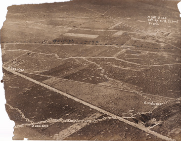 The Beechworth Burke Museum
Photograph
... an aerial view of trenches in France. The image mostly shows rural... an aerial view of trenches in France. The image mostly shows rural ...Taken some time between 1914-18, the photograph depicts an aerial view of trenches in France. The image mostly shows rural landscape, although there is a house in the bottom right corner. A dotted line has been drawn across the photograph, marking the section of trenches that belonged to British forces during World War I. It is believed that the line marking on this record denotes a section of the Western Front. The Western Front was the main theatre of war during World War I. Following the outbreak of war in August 1914, the German Army opened the Western Front by invading Luxembourg and Belgium, then gaining military control of important industrial regions in France. The German advance was halted with the Battle of the Marne. Following the Race to the Sea, both the French-British and German armies dug in along a meandering line of fortified trenches, stretching from the North Sea to the Swiss frontier with France. Between 1915 and 1917 there were several offensives along the Western Front. The attacks employed massive artillery bombardments and massed infantry advances. Entrenchments, machine gun emplacements, barbed wire and artillery repeatedly inflicted severe casualties during attacks and counter-attacks and no significant advances were made. Among the most notable of these offensives were the Battle of Verdun (1916), the Battle of the Somme (1916), and the Battle of Passchendaele (1917).The record is historically significant due to its connection to World War I. This conflict is integral to Australian culture as it was the single greatest loss of life and the greatest repatriation of casualties in the country's history. Australia’s involvement in the First World War began when the Australian government established the Australian Imperial Force (AIF) in August 1914. Immediately, men were recruited to serve the British Empire in the Middle East and on the Western Front. The record has strong research potential. This is due to the ongoing public and scholarly interest in war, history, and especially the ANZAC legend, which is commemorated annually on 25 April, known as ANZAC Day.Sepia rectangular photograph printed on matte photographic paper.Obverse: A.3FE.O.146 / G2R 29 . 6 . 18 (Y p.m) / F= 10 1/4 / British Line / ------------------------------------------ / P. 250 1040 / 0. 30d. 0010 / 0. 30d. 3070 /military album, military, war, wwi, world war i, france, great britain, trenches, village, rural, western front -
 Kew Historical Society Inc
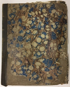
Album, Louisa G Thomas, Victorian Era Sketchbook, 1862
... are signed and dated, and include rural landscapes and seascapes..., and include rural landscapes and seascapes, archaeological sites ...Louisa Thomas married Henry Gipps (1837-91)in 1863. They had six sons and two daughters. While Louisa and Henry Gipps were to die in Sussex, two of their sons, Frederick George De Visme Gipps (1867-1953) and Richard Brook Woodthorpe Gipps (c.1872-1946) migrated to Queensland, possibly bringing with them their mother’s sketchbook.The collection of artworks that are included in the sketchbook are often of outstanding aesthetic and artistic significance. In the variety of subject matter and the geographical places represented, it is historically significant as a document recording the postings of Colonel Henry Gipps, 9th Norfolk Regiment, and his wife Louisa to locations in the Mediterranean and West Asia. The large bound sketchbook has a marbled cover with blue binding. The name Louisa Goulburn Thomas and the date 1862 are faintly inscribed in pencil on the front page. However the book contains pen and ink and pencil drawings, watercolours, and photographs, which both predate and postdate 1862. The approximately 75 works are loose-leafed items and [currently] do not form a chronological, geographical or thematic sequence. Creators identified on some drawings and watercolours include Mary Julia Wilder Thomas, JFV Wright, ELG (Edward Louis de Bondell Gipps?), L Nicholson, Bertha Isadore Thomas, and HG (Henry Gipps?). Many of the works are signed and dated, and include rural landscapes and seascapes, archaeological sites, animal studies, and portraits. While most of the works were created in the British Isles, others are scenes of Venice, the Ionian Islands, Cape Town, Hong Kong and Japan. [A number of the ‘oriental’ paintings on silk were probably purchased from local artists.] The art works in the book are at various stages of completion and represent a diverse range of artistic skills. What may be the earliest work in the sketchbook is a drawing of three uniformed soldiers. An annotation on the reverse records that the drawing is of a Group of Soldiers after [Philipp Jakob] de Southerbourg 1830. The birth of Louisa Thomas' oldest son, William Henry Houston Meyrick Gipps (1864-1903) in Corfu perhaps explains why a number of scenes and items in the album are of the Ionian Islands. Louisa is probably the creator of a number of still life and botanical studies in the album. These range from floral studies to a bird’s nest. The painting of objects was to remain a socially ‘approved’ specialty of amateur and professional women artists into the 20th century. The complete contents of the album will be uploaded to accompany this record. Some items may be published separately on Victorian Collections, but will acknowledge their origins in the sketchbook."Louisa Goulburn Thomas / 1862"victorian sketchbooks, manuscripts - kew historical society, 9th norfolk regiment, rosemary (gipps) vaughan smith, vaughan-smith collection -
 Kiewa Valley Historical Society
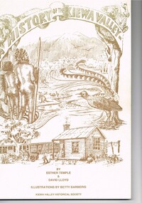
Book - A History of the Kiewa Valley, Kiewa Valley Historical Society, A History of the Kiewa Valley by Esther Temple and David Lloyd, Circa 1991
... that has been gradually changing to a more commercial rural... that has been gradually changing to a more commercial rural ...This book was compiled by Esther Temple and David Lloyd with illustrations by Betty Barberis and additional material provided by Clare Roper, Joan Macdonald, Wilma Davies and Nell Bateman. The book was first penned in 1971. It briefly covers the period from the indigenous tribes(broken down into family groupings) known as the "first Australians" who lived in the valley well before English settlers arrived. first white settlement (graziers, miners, stockmen) to smaller settlements.The development or transformation from a pristine(hunter/gatherer) valley environment to one that has been gradually changing to a more commercial rural/industrial landscaped valley. This transformation was made within a time span of two hundred years. The book details the first pioneers and their descendants, along with the changes to their environments both domestic and commercial. The book highlights dates and events that shaped the "feel" of the valley. The extreme hardships faced by pioneer families during the extremely isolated times away from "civilisation".This publication provides an insight to the struggles and victories against the harsh Australian bushland by people who had not been raised in such a sometimes inhospitable environment. It was this transformation which instilled into the Australian psyche of self sufficiency and the ability to grasp onto ideas or "bush" remedies to overcome enormous difficulties. It is is ability that has produced the many inventions useful in the 20th and 21st centuries.This book has a 250 g/m cream coloured cover with print and drawings of rural aspects of historical significance ( Aboriginal and early white settlers). The book contains 124 pages of black and white photographs(139), black and white sketches(75), two pages of sketches and freehand drawings, two freehand maps one county lease /subdivision plan and black and white printing. See KVHS 0237 (B) for the official invitation to the launch of the book.The front top cover heading(in shaded print and enclosed in a banner form) "A HISTORY OF THE KIEWA VALLEY" The bottom printing "BY ESTHER TEMPLE & DAVID LLOYD ILLUSTRATIONS BY BETTY BARBERIS" and at the very bottom "KIEWA VALLEY HISTORICAL SOCIETY" oN THE BOOK SPINE "A HISTORY OF THE KIEWA VALLEY.....BY ESTHER TEMPLE & DAVID LLOYD"early settlers, dederang, tawonga, mount beauty, sec vic hydro electricity, falls creek early settlers, bonegilla -
 Ballarat Heritage Services
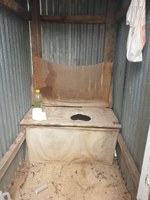
Photograph - Photograph - Colour, Clare Gervasoni, Toilet at St Laurence O'Toole Catholic Church, Sandon, 2017, 08/04/2023
... of graves and cemetery architecture, and the grassed and treed rural... of graves and cemetery architecture, and the grassed and treed rural ...St Laurence O'Toole church and cemetery is located in a rural setting at 801/821 Creswick-Newstead Rd, Sandon. Originally a small wooden school (22’x14’) was erected in Sandon by Father Patrick Smyth (who was involved in the Eureka Stockade movement) in 1859. It was also used for Mass and became known as a chapel. In June 1882 tenders were called for the construction of a brick Church by the Castlemaine architect, T.F. Kibble, and it was built at a cost of 1000 pounds. The church was blessed by Archbishop Goold on 06 May 1883 and dedicated to St Laurence O'Toole. The brick building demonstrates original design qualities of a Victorian Rudimentary Gothic style, including the steeply pitched, parapet gable roof form, together with a central steeply pitched, gabled porch that projects slightly from the main gable end. Other intact qualities include the exposed brick wall construction, lapped galvanised corrugated iron roof cladding, minor gabled porch at the rear, small ventilation dormers nearby the roof ridgeline, series of stone steps that lead to the central porch with its double pointed door opening and vertical boarded doors, simple rose window in the main gable end, pointed windows, brick buttresses with double lower copings, and the light masonry detailing (the banding marking the floor level within, buttress copings, window and door surrounds and quoins, and the drip moulds).(Shire of Mount Alexander: Heritage Study of the former Shire of Newstead, 2000) The visually connected cemetery demonstrates important visual qualities formed by the regular rows of graves and cemetery architecture, and the grassed and treed rural landscape. It is a rare and substantially intact example of a Victorian Catholic Church with a cemetery in its churchyard. Many headstones and cemetery architecture, date from the 19th century and represent some fine examples of masonry craftsmanship. Some refurbisments occurred during the 1940s and in 2002 a major restoration project was undertaken from roof to footings, by a dedicated band of volunteers and trades people. Work was completed mid 2003 and in November 2003 St Laurence’s was re-dedicated with the celebration of Mass and a picnic tea. Colour photograph of a long drop toliet at the Catholic Church, Sandon, Victoria.sandon, sandon cemetery, st laurence o'toole catholic church, sandon -
 Ballarat Heritage Services
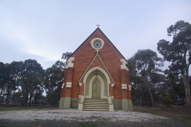
Photograph - Photograph - Colour, Lisa Gervasoni, St Laurence O'Toole Catholic Church, Sandon, 2017, 16/07/2017
... of graves and cemetery architecture, and the grassed and treed rural... of graves and cemetery architecture, and the grassed and treed rural ...St Laurence O'Toole church and cemetery is located in a rural setting at 801/821 Creswick-Newstead Rd, Sandon. Originally a small wooden school (22’x14’) was erected in Sandon by Father Patrick Smyth (who was involved in the Eureka Stockade movement) in 1859. It was also used for Mass and became known as a chapel. In June 1882 tenders were called for the construction of a brick Church by the Castlemaine architect, T.F. Kibble, and it was built at a cost of 1000 pounds. The church was blessed by Archbishop Goold on 06 May 1883 and dedicated to St Laurence O'Toole. The brick building demonstrates original design qualities of a Victorian Rudimentary Gothic style, including the steeply pitched, parapet gable roof form, together with a central steeply pitched, gabled porch that projects slightly from the main gable end. Other intact qualities include the exposed brick wall construction, lapped galvanised corrugated iron roof cladding, minor gabled porch at the rear, small ventilation dormers nearby the roof ridgeline, series of stone steps that lead to the central porch with its double pointed door opening and vertical boarded doors, simple rose window in the main gable end, pointed windows, brick buttresses with double lower copings, and the light masonry detailing (the banding marking the floor level within, buttress copings, window and door surrounds and quoins, and the drip moulds).(Shire of Mount Alexander: Heritage Study of the former Shire of Newstead, 2000) The visually connected cemetery demonstrates important visual qualities formed by the regular rows of graves and cemetery architecture, and the grassed and treed rural landscape. It is a rare and substantially intact example of a Victorian Catholic Church with a cemetery in its churchyard. Many headstones and cemetery architecture, date from the 19th century and represent some fine examples of masonry craftsmanship. Some refurbisments occurred during the 1940s and in 2002 a major restoration project was undertaken from roof to footings, by a dedicated band of volunteers and trades people. Work was completed mid 2003 and in November 2003 St Laurence’s was re-dedicated with the celebration of Mass and a picnic tea. Colour photograph of a brick church at Sandon, Victoria.sandon, sandon cemetery, st laurence o'toole catholic church, sandon -
 Ballarat Heritage Services
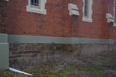
Photograph - Photograph - Colour, Clare Gervasoni, Sandstone foundations at St Laurence O'Toole Catholic Church, Sandon, 2017, 16/07/2017
... of graves and cemetery architecture, and the grassed and treed rural... of graves and cemetery architecture, and the grassed and treed rural ...St Laurence O'Toole church and cemetery is located in a rural setting at 801/821 Creswick-Newstead Rd, Sandon. Originally a small wooden school (22’x14’) was erected in Sandon by Father Patrick Smyth (who was involved in the Eureka Stockade movement) in 1859. It was also used for Mass and became known as a chapel. In June 1882 tenders were called for the construction of a brick Church by the Castlemaine architect, T.F. Kibble, and it was built at a cost of 1000 pounds. The church was blessed by Archbishop Goold on 06 May 1883 and dedicated to St Laurence O'Toole. The brick building demonstrates original design qualities of a Victorian Rudimentary Gothic style, including the steeply pitched, parapet gable roof form, together with a central steeply pitched, gabled porch that projects slightly from the main gable end. Other intact qualities include the exposed brick wall construction, lapped galvanised corrugated iron roof cladding, minor gabled porch at the rear, small ventilation dormers nearby the roof ridgeline, series of stone steps that lead to the central porch with its double pointed door opening and vertical boarded doors, simple rose window in the main gable end, pointed windows, brick buttresses with double lower copings, and the light masonry detailing (the banding marking the floor level within, buttress copings, window and door surrounds and quoins, and the drip moulds).(Shire of Mount Alexander: Heritage Study of the former Shire of Newstead, 2000) The visually connected cemetery demonstrates important visual qualities formed by the regular rows of graves and cemetery architecture, and the grassed and treed rural landscape. It is a rare and substantially intact example of a Victorian Catholic Church with a cemetery in its churchyard. Many headstones and cemetery architecture, date from the 19th century and represent some fine examples of masonry craftsmanship. Some refurbisments occurred during the 1940s and in 2002 a major restoration project was undertaken from roof to footings, by a dedicated band of volunteers and trades people. Work was completed mid 2003 and in November 2003 St Laurence’s was re-dedicated with the celebration of Mass and a picnic tea. Details of the exterior of St Laurence O'Toole Catholic Church, Sandon in Central Victoria.sandon, sandon cemetery, st laurence o'toole catholic church, sandon, sandstone, foundations -
 Ballarat Heritage Services
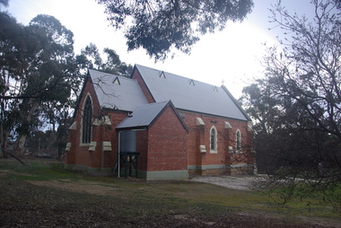
Photograph - Photograph - Colour, Clare Gervasoni, St Laurence O'Toole Catholic Church, Sandon, 2017, 16/07/2017
... of graves and cemetery architecture, and the grassed and treed rural... of graves and cemetery architecture, and the grassed and treed rural ...St Laurence O'Toole church and cemetery is located in a rural setting at 801/821 Creswick-Newstead Rd, Sandon. Originally a small wooden school (22’x14’) was erected in Sandon by Father Patrick Smyth (who was involved in the Eureka Stockade movement) in 1859. It was also used for Mass and became known as a chapel. In June 1882 tenders were called for the construction of a brick Church by the Castlemaine architect, T.F. Kibble, and it was built at a cost of 1000 pounds. The church was blessed by Archbishop Goold on 06 May 1883 and dedicated to St Laurence O'Toole. The brick building demonstrates original design qualities of a Victorian Rudimentary Gothic style, including the steeply pitched, parapet gable roof form, together with a central steeply pitched, gabled porch that projects slightly from the main gable end. Other intact qualities include the exposed brick wall construction, lapped galvanised corrugated iron roof cladding, minor gabled porch at the rear, small ventilation dormers nearby the roof ridgeline, series of stone steps that lead to the central porch with its double pointed door opening and vertical boarded doors, simple rose window in the main gable end, pointed windows, brick buttresses with double lower copings, and the light masonry detailing (the banding marking the floor level within, buttress copings, window and door surrounds and quoins, and the drip moulds).(Shire of Mount Alexander: Heritage Study of the former Shire of Newstead, 2000) The visually connected cemetery demonstrates important visual qualities formed by the regular rows of graves and cemetery architecture, and the grassed and treed rural landscape. It is a rare and substantially intact example of a Victorian Catholic Church with a cemetery in its churchyard. Many headstones and cemetery architecture, date from the 19th century and represent some fine examples of masonry craftsmanship. Some refurbisments occurred during the 1940s and in 2002 a major restoration project was undertaken from roof to footings, by a dedicated band of volunteers and trades people. Work was completed mid 2003 and in November 2003 St Laurence’s was re-dedicated with the celebration of Mass and a picnic tea. Brick church at Sandon, Victoriasandon, sandon cemetery, st laurence o'toole catholic church, sandon -
 Ballarat Heritage Services
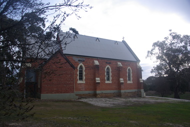
Photograph, Clare Gervasoni, St Laurence O'Toole Catholic Church, Sandon, 2017, 16/07/2017
... of graves and cemetery architecture, and the grassed and treed rural... of graves and cemetery architecture, and the grassed and treed rural ...St Laurence O'Toole church and cemetery is located in a rural setting at 801/821 Creswick-Newstead Rd, Sandon. Originally a small wooden school (22’x14’) was erected in Sandon by Father Patrick Smyth (who was involved in the Eureka Stockade movement) in 1859. It was also used for Mass and became known as a chapel. In June 1882 tenders were called for the construction of a brick Church by the Castlemaine architect, T.F. Kibble, and it was built at a cost of 1000 pounds. The church was blessed by Archbishop Goold on 06 May 1883 and dedicated to St Laurence O'Toole. The brick building demonstrates original design qualities of a Victorian Rudimentary Gothic style, including the steeply pitched, parapet gable roof form, together with a central steeply pitched, gabled porch that projects slightly from the main gable end. Other intact qualities include the exposed brick wall construction, lapped galvanised corrugated iron roof cladding, minor gabled porch at the rear, small ventilation dormers nearby the roof ridgeline, series of stone steps that lead to the central porch with its double pointed door opening and vertical boarded doors, simple rose window in the main gable end, pointed windows, brick buttresses with double lower copings, and the light masonry detailing (the banding marking the floor level within, buttress copings, window and door surrounds and quoins, and the drip moulds).(Shire of Mount Alexander: Heritage Study of the former Shire of Newstead, 2000) The visually connected cemetery demonstrates important visual qualities formed by the regular rows of graves and cemetery architecture, and the grassed and treed rural landscape. It is a rare and substantially intact example of a Victorian Catholic Church with a cemetery in its churchyard. Many headstones and cemetery architecture, date from the 19th century and represent some fine examples of masonry craftsmanship. Some refurbisments occurred during the 1940s and in 2002 a major restoration project was undertaken from roof to footings, by a dedicated band of volunteers and trades people. Work was completed mid 2003 and in November 2003 St Laurence’s was re-dedicated with the celebration of Mass and a picnic tea. Colour photograph of a red brick church in Sandon. sandon, sandon cemetery, st laurence o'toole catholic church, sandon