Showing 10839 items matching "sites"
-
 Greensborough Historical Society
Article - Article - Website, Wallaby Creek Weir, Aqueduct and associated sites, Kinglake, 2007
... Wallaby Creek Weir, Aqueduct and associated sites, Kinglake ...A short history of Kinglake's Wallaby Creek Weir and aqueduct in relation to Melbourne's water supply. Paper copy of website article, 7 p. text.melbourne water supply, kinglake, wallaby creek weir, aqueducts -
 Greensborough Historical Society
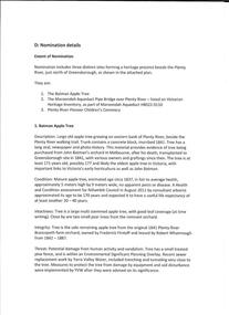
Folder of Documents, Anne Paul, Plenty River Heritage sites / Anne Paul, 1937_
... Plenty River Heritage sites / Anne Paul ...This collection of correspondence, articles and photographs was collected by GHS member Anne Paul in support of Heritage overlays for the Pioneer Children's Graves, Batman Apple Tree and Maroondah Aqueduct.Blue plastic folder containing a large number of documents and images.anne paul, pioneer childrens cemetery, batman apple tree, maroondah aqueduct -
 Greensborough Historical Society
Newspaper clipping, 17 Watsonia home sites sell for 1585 [pounds] average, 1950c
... 17 Watsonia home sites sell for 1585 [pounds] average ...A scrap of newspaper with land prices in Watsonia's "Hillboro" estate. Prices are pre-decimal currency, estimated mid 1950s.AN indication of land prices in the 1950s.Torn clippingwatsonia -
Ringwood and District Historical Society
Envelope, Packet: Private Sale Prospectus for Housing - Heatherdale Rd Ringwood and other sites 1940-89
... Rd Ringwood and other sites 1940-89 ...Prospectus for private sale of 109-113 Heatherdale Road Ringwood; Housing 1940-1989 -
 Ringwood and District Historical Society
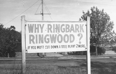
Photograph, "Why Ringbark Ringwood?" Council signs located at various sites around Ringwood in a drive to retain trees in the area - c.1960s
... sites around Ringwood in a drive to retain trees in the area - c ...Typed below photograph, 'Council signs around Ringwood in a drive to retain trees of area.' -
Stawell Historical Society Inc
Archive - Book, Registration Of Residence Sites 3/1/1871 - 17/8/1882, 1871
... Registration Of Residence Sites 3/1/1871 - 17/8/1882 ...Residence Area Miners Right Mining used by Stawell ShireVery Large Brown Leather Ledger with marbling on inside cover. Red Label on Spine Registration Booklocal government, miners right -
Stawell Historical Society Inc
Archive - Book, Stawell Shire, Registration Of Residence Sites 20-8-1900 - 22-9-1904, 1900
... Registration Of Residence Sites 20-8-1900 - 22-9-1904 ...Residence Area Miners Right Mining used by Stawell ShireVery Large Burgandy Leather Ledger with marbling on inside cover. Red Spine and Corners IndexedRegister of Residence Area Book 6Plocal government, miners right -
Stawell Historical Society Inc
Archive - Book, Stawell Shire, Registration Of Residence Sites / Areas 23-4-1890 - 6-2-1900, 1900
... Registration Of Residence Sites / Areas 23-4-1890 - 6-2 ...Residence Area Miners Rightused by Stawell ShireLarge Light Brown Leather Ledger Red Spine and CornersRegister of Residence Areas & Crown local government, miners right -
Stawell Historical Society Inc
Archive - Book, Stawell Shire, Registration Of Residence Sites 13-9-1895 - 8-3-1898, 1895
... Registration Of Residence Sites 13-9-1895 - 8-3-1898 ...Residence Area Miners Rightused by Stawell ShireLarge Burgandy Covered Leather Ledger Red Spine and CornersGeneral Register 4 local government, miners right -
Stawell Historical Society Inc
Archive - Book, Stawell Shire, Registration Of Residence Sites 10-3-1898 to 18-8-1900, 1895
... Registration Of Residence Sites 10-3-1898 to 18-8-1900 ...Residence Area Miners Rightused by Stawell ShireLarge Burgandy Covered Leather Ledger Red Spine and CornersGeneral Register 5P & Crown local government, miners right -
Stawell Historical Society Inc
Archive - Book, Stawell Shire, Registration Of Residence Sites & Index 19-8-1882 - 21-4-1990, 1882
... Registration Of Residence Sites & Index 19-8-1882 - 21-4 ...Residence Area Miners Rightused by Stawell ShireLarge Green Covered Leather Ledger with Fawn Covered Spine and CornersResidence Area Register RS3 local government, miners right -
Stawell Historical Society Inc
Archive - Book, Stawell Shire, Registration Of Residence Sites 20-8-1900 - 12-6-1903, 1900
... Registration Of Residence Sites 20-8-1900 - 12-6-1903 ...Residence Area Miners Rightused by Stawell ShireLarge Burgandy Covered Leather Ledger with Red Covered Spine and CornersGeneral Register 6P local government, miners right -
Stawell Historical Society Inc
Archive - Book, Stawell Shire, Registration Of Residence Sites 22-9-1904 - 12-4-1906, 1904
... Registration Of Residence Sites 22-9-1904 - 12-4-1906 ...Residence Area Miners Rightused by Stawell ShireLarge Burgandy Covered Leather Ledger with Red Covered Spine and Corners with indexRegister of Residence Areas Index of Books 7P, 8P, 9P, 10P local government, miners right -
Stawell Historical Society Inc
Archive - Book, Stawell Shire, Registration Of Residence Sites 15-6-1903 to 22-9-1906, 1903
... Registration Of Residence Sites 15-6-1903 to 22-9-1906 ...Residence Area Miners Rightused by Stawell ShireLarge Dark Grey Covered Leather Ledger with Red Covered Spine and Corners with indexGeneral Register 7P and Crown local government, miners right -
Stawell Historical Society Inc
Archive - Book, Stawell Shire, Registration Of Residence Sites 24-9-1908 to 9-11-1919, 1906
... Registration Of Residence Sites 24-9-1908 to 9-11-1919 ...Residence Area Miners Right Also Catalogued as 4257used by Stawell ShireLarge Dark Navy Blue Covered Leather Ledger with Red Covered Spine and Corners with indexGeneral Register 8P local government, miners right -
Stawell Historical Society Inc
Archive - Book, Stawell Shire, Registration Of Residence Sites 10-11-1910 - 22-10-1915, 1910
... Registration Of Residence Sites 10-11-1910 - 22-10-1915 ...Residence Area Miners Right used by Stawell ShireLarge Blue Covered Leather Ledger with Brown Covered Spine and Corners with indexGeneral Register 9P local government, miners right -
Stawell Historical Society Inc
Archive - Book, Stawell Shire, Registration Of Residence Sites & Index 25-10-1915 - 6-11-1924, 1915
... Registration Of Residence Sites & Index 25-10-1915 - 6-11 ...Residence Area Miners Right used by Stawell ShireLarge Green Covered Leather Ledger with Red Covered Spine and Corners with indexRegister of Residence Areas 10P local government, miners right -
Stawell Historical Society Inc
Archive - Book, Stawell Shire, Registration Of Residence Sites & Index 20-11-1924 - 28-7-1931, 1924
... Registration Of Residence Sites & Index 20-11-1924 - 28-7 ...Residence Area Miners Right used by Stawell ShireLarge Brown Covered Leather Ledger with Red Covered Label on SpineRegister of Claims 11P local government, miners right -
Stawell Historical Society Inc
Archive - Book, Stawell Shire, Registration Of Residence Sites 28-7-1931 - 20-6-1934, 1931
... Registration Of Residence Sites 28-7-1931 - 20-6-1934 ...Residence Area Miners Right used by Stawell ShireLarge Brown Covered Leather Ledger with Label on front coverStawell Ararat Mining District Registration Book 12P local government, miners right -
 Latrobe Regional Gallery
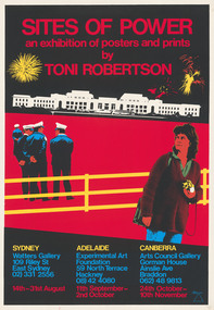
Print, ROBERTSON, Toni. born 1953 Sydney, Sites of Power – An exhibition of posters and prints by Toni Robertson, c. 1984
... Sites of Power – An exhibition of posters and prints by ...Silkscreen printNot signed. Not dated.screenprint, power, poster, exhibition, police -
Koorie Heritage Trust
Book, Brown, Rik, The upper Yarra River corridor : sites of conservation significance, 1993
... The upper Yarra River corridor : sites of conservation ...179 p.; maps; appendices; 30 cm.environmental protection -- victoria -- yarra river region. floodplain management -- victoria -- yarra river region. ecology -- victoria -- yarra river region. biodiversity conservation -- victoria -- yarra river region. yarra river region (vic.) -
Whitehorse Historical Society Inc.
Document, List of significant sites in Nunawading, c1994
... List of significant sites in Nunawading ...Non annotated list - probably prepared in preparation for the City of Nunawading Heritage Survey Project.Non annotated list - probably prepared in preparation for the City of Nunawading Heritage Survey Project.Non annotated list - probably prepared in preparation for the City of Nunawading Heritage Survey Project.city of nunawading heritage survey, arrowsmith, valda -
 Whitehorse Historical Society Inc.
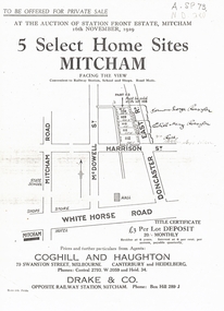
Document, 5 Select Homes Sites Mitcham, 16/11/1929 12:00:00 AM
... 5 Select Homes Sites Mitcham ...Auction of land in Mitcham.Auction of land in Mitcham. Includes schetch map of locations and names of purchasersAuction of land in Mitcham. auction, station front estate, mitcham road, mcdowell street, doncaster east road, whitehorse road, coghill & haughton estate agents, drake & co estate agents, roeszler, norman george, edith mary, reid harrison street -
 Whitehorse Historical Society Inc.
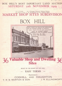
Document, Market Shop Sites subdivision, 20/11/1929 12:00:00 AM
... Market Shop Sites subdivision ...5 pages describing sale of land in Whitehorse Road,5 pages describing sale of land in Whitehorse Road, Market Street, Box Hill5 pages describing sale of land in Whitehorse Road,land subdivision, market street, box hill, coghill & haughton, t.r.b. morton & son, ellingworth, john roger -
Whitehorse Historical Society Inc.
Article, Koori Sites, 5/05/1999 12:00:00 AM
... Koori Sites ...Article about Aboriginal history in the City of Whitehorse.Article about Aboriginal history in the City of Whitehorse.Article about Aboriginal history in the City of Whitehorse.sacred sites, aborigines, wurundjeri - willam tribe, presland, gary, friends for whitehorse reconciliation group, millane, bernie, gittens, jaxon, boonwurning tribe -
Whitehorse Historical Society Inc.
Article, Sites for training scheme, 1993
... Sites for training scheme ...Vacant land in Nunawading should be used for an employment training scheme to help long term unemployed.Vacant land in Nunawading should be used for an employment training scheme to help long term unemployed. Council wants to know what the community thinks about the idea.Vacant land in Nunawading should be used for an employment training scheme to help long term unemployed.youth, shambrook, tim, gardiner, bob -
 Whitehorse Historical Society Inc.
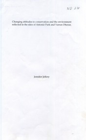
Book - Report, Changing attitudes to conservation and the environment reflected in the sites of Antonio Park and Yarran Dheran, 1997
... reflected in the sites of Antonio Park and Yarran Dheran. ...A carefully documented essay on the history of Antonio Park and Yarran Dheran as examples of changes in public attitude to conservation.A carefully documented essay on the history of Antonio Park and Yarran Dheran as examples of changes in public attitude to conservation. References are made to the Aboriginal uses of the land, the roles of the Schwerkolt and Antonio families, the Nunawading City Council and the establishment of Antonio Park Primary School. The importance of appropriate botanic species is stressed. 14 pages. Includes bibliography.A carefully documented essay on the history of Antonio Park and Yarran Dheran as examples of changes in public attitude to conservation. antonio park, mitcham, yarran dheran, antonio family, mullum mullum creek, environment -
 Whitehorse Historical Society Inc.
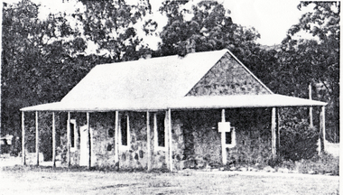
Photograph, Historic Buildings and sites, 1966
... Historic Buildings and sites ...Extract from Historic Buildings of Victoria showing Schwerkolt Cottageschwerkolt cottage -
Whitehorse Historical Society Inc.
Map, Aboriginal sites in the City of Doncaster-Templestowe, 1/03/1991 12:00:00 AM
... Aboriginal sites in the City of Doncaster-Templestowe ...Map of City of Doncaster and Templestowe.Map of City of Doncaster and Templestowe showing location of stone artefacts and scarred trees.Map of City of Doncaster and Templestowe. aborigines, city of doncaster and templestowe -
Whitehorse Historical Society Inc.
Pamphlet, Aboriginal sites of Archaeological significance, 1/03/1991 12:00:00 AM
... Aboriginal sites of Archaeological significance. ...Illustrated pamphlet with map, photographs and articles.Illustrated pamphlet with map, photographs and articles.Illustrated pamphlet with map, photographs and articles.aborigines, barak, william