Showing 73 items
matching somers trail
-
 Eltham District Historical Society Inc
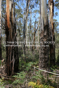
Photograph - Digital Photograph, Alan King, Manna Gums at the Gawa Wurundjeri Aboriginal Resource Trail, 28 December 2007
Manna Gum is a species of a small to a very tall tree that is endemic to south-eastern Australia. These particular trees are part of the Gawa Wurundjeri Resource Trail at Watsons Creek. Signs share information about how the Wurundjeri people lived near the creek and used the land to obtain bush foods, medicines, tools, shelter and clothes. The trail introduces visitors to the indigenous flora and fauna, including manna gums, Lomandra (used to weave baskets) and wombat burrows. Published: Nillumbik Now and Then / Marguerite Marshall 2008; photographs Alan King with Marguerite Marshall.; p3This collection of almost 130 photos about places and people within the Shire of Nillumbik, an urban and rural municipality in Melbourne's north, contributes to an understanding of the history of the Shire. Published in 2008 immediately prior to the Black Saturday bushfires of February 7, 2009, it documents sites that were impacted, and in some cases destroyed by the fires. It includes photographs taken especially for the publication, creating a unique time capsule representing the Shire in the early 21st century. It remains the most recent comprehenesive publication devoted to the Shire's history connecting local residents to the past. nillumbik now and then (marshall-king) collection, gawa wurundjeri aboriginal resource trail, manna gums, watsons creek -
 Eltham District Historical Society Inc
Photograph, Fay Bridge, Ruins beside the Diamond Creek at Wattle Glen, 13 October 2016
The newly constructed Diamond Creek Trail from Diamond Creek to Wattle Glen completed in February 2021 winds around these ruins just pass the high transmission power lines near Herberts Lane and Collard Drive From Jean Verso, Nillumbik Historical Society, 15 April 2021 William Wandless Herbert bought the surrounding 100 acres in 1852. He was a native of Northumberland and the Scottish Borders who arrived in Melbourne in 1847. The house on the top of the mound would have been built not long after he bought the land; the farm was named "Greenhills". He married Elizabeth Wilson, daughter of John Wilson who had been in Diamond Creek since about 1846. Their first child was born in 1854 so there would be some form of dwelling from about that time. They had eight children who all survived to a good age. His will describes the house as part stone and part wood and of four rooms. Nillumbik Historical Society (NHS) believe it was one of the earliest if not the earliest house, in this part of the district. The remains of the stone house foundations are on top of the mound (photos on the VHD page) and the barn walls are on the north and to the east side of the mound. NHS is not sure how much or which part of the surrounding area was covered by the barns but they were large enough to hold dances after the race meetings that were held in the late 1880's on the adjacent creek flats. It would make sense with the lay of the land that they covered some of the ground to the north and east and used for farm storage, packing sheds for their apple and pear orchards and also for supporting the Nillumbik Gold Mine the family worked to the north up the gully. The path that comes down the gully and runs into the trail goes past the mine site which was on the west side of the gully a couple of hundred metres up from the flats. Heritage Victoria link for the site - https://vhd.heritagecouncil.vic.gov.au/places/12203fay bridge collection, 2016-10-13, diamond creek, diamond creek trail, ruins, wattle glen, william wandless herbert, greenhills, elizabeth wilson -
 Eltham District Historical Society Inc
Photograph, Fay Bridge, Remains of apple orchard near the Diamond Creek, Wattle Glen, 11 October 2018
The newly constructed Diamond Creek Trail from Diamond Creek to Wattle Glen completed in February 2021 winds past these apple trees that possibly lined the entrance to the Greenhills property From Jean Verso, Nillumbik Historical Society, 15 April 2021 William Wandless Herbert bought the surrounding 100 acres in 1852. He was a native of Northumberland and the Scottish Borders who arrived in Melbourne in 1847. The house on the top of the mound would have been built not long after he bought the land; the farm was named "Greenhills". He married Elizabeth Wilson, daughter of John Wilson who had been in Diamond Creek since about 1846. Their first child was born in 1854 so there would be some form of dwelling from about that time. They had eight children who all survived to a good age. His will describes the house as part stone and part wood and of four rooms. Nillumbik Historical Society (NHS) believe it was one of the earliest if not the earliest house, in this part of the district. The remains of the stone house foundations are on top of the mound (photos on the VHD page) and the barn walls are on the north and to the east side of the mound. NHS is not sure how much or which part of the surrounding area was covered by the barns but they were large enough to hold dances after the race meetings that were held in the late 1880's on the adjacent creek flats. It would make sense with the lay of the land that they covered some of the ground to the north and east and used for farm storage, packing sheds for their apple and pear orchards and also for supporting the Nillumbik Gold Mine the family worked to the north up the gully. The path that comes down the gully and runs into the trail goes past the mine site which was on the west side of the gully a couple of hundred metres up from the flats. Heritage Victoria link for the site - https://vhd.heritagecouncil.vic.gov.au/places/12203fay bridge collection, 2018-10-11, diamond creek, diamond creek trail, elizabeth wilson, greenhills, wattle glen, william wandless herbert, apple trees -
 Glen Eira Historical Society
Letter - Rosstown Railway
... along the trail, including photographs of some of these sites... map and guide of the Rosstown Rail Trail, including a brief ...This file contains four items: 1/A black and white photocopy of a letter dated either 07/08/1889 or 09/08/1889, from Robert Lundon to an unidentified recipient discussing an agreement reached between the author – on behalf of the recipient – and Soon Hang Hi in regard, in regards to the allotment known as Webber’s. The agreement is outlined in the letter in what appears to be Chinese characters, and includes the marks of Robert Lundon and Soon Hang Hi. File note from Joy Wu states that the calligraphy is not Mandarin or traditional Chinese. 2/Three sheets of hand-written working notes with information taken from the Victorian Government Gazette on THE ROSSTOWN AND MURRUMBEENA LAND COMPANY LIMITED, THE ROSSTOWN JUNCTION RAILWAY AND PROSPERITY COMPANY LIOMITED, and THE ROSSTOWN JUNCTION, ELSTERNWICK, AND OAKLEIGH RAILWAY COMPANY LIMITED, covering dates between 1887 and 1894. The notes concern meetings and creditors claims relevant to the companies, with reference numbers for the information source. Date and author of the notes are not recorded. 3/A black and white photocopy of the a partial map of the Rosstown Railway and surrounding area, undated. The map includes the names of landholders in the areas of Brighton, Garden Vale and Elsternwick, as well as other railway lines present in the region. 4/A fold-out map and guide of the Rosstown Rail Trail, including a brief general history of Caulfield as well as a more extensive biography of William Murray Ross and the Rosstown Railway. The map marks and describes significant sites along the trail, including photographs of some of these sites, provided by DF Jowett.documents, correspondence, webber’s, lundon robert, chinese characters, ethnic communities, signatures, text, settlements, taxes, fraser john grieves, lovell r.h., price davies, meetings, communication activities, soon hang hi, commercial events and activities, the rosstown and murrumbeena land company limited, victorian government gazette, bulmer richard, parry john, osment henry, shareholders, creditors claims, the rosstown junction railway and property company limited, finch and best, lawyers, the rosstown junction elsternwick and oakleigh railway company limited, cameron w.c., phillips p.d., garden vale, elsternwick, elsternwick railway station, rosstown, rosstown railway, thomas street, bay street, kooyong road, melbourne and brighton railway, hawthorn road, bambra road, caulfield and frankston railway, booran road, grange road, koornang road, murrumbeena road, north road, north road railway station, east brighton railway station, south road, railway routes, railway lines, railways, land transport, murphy j., caulfield, hamilton t.f., dane p., holloway, webb, ailee john, payne t.b., brodie chas, dane john, o’neil h., mccombie john, mcmillane a., smyth c.d., cooper, ebden, landholders, jeffrey j.d., gill j., balcombe a.e., cooper h., mcnab j., white j., sutherland j., greeves a.f.a., newton m.c., chamley f.b., fowler j., inglis p., grant t., stooke j., swanson g., cochrane c., adams e.b., mccombie thas, keyes robert, brighton cemetery, burials grounds and graveyards, war-ein road, were j.b., holland j., mcmahon c., winter t.l.m., dendy henry, mitchell w., jackson s., were j.e., wickham francis dawe, bryant jane, east brighton railway station, railway stations, maps, allotments, land titles, roads and streets, rosstown rail trail, city of glen eira, tourism, trains, tourism information bureaus, tours, pamphlets, elsternwick railway park, oakleigh junction, princes park, ee gunn reserve, packer park, sites, jowett d.f., weickhardt i.g., return to rosstown: railways land sales and sugar beet ventures in caulfield, land sales, walking trails, ross william murray, transport objects, locomotion, walking, cycling, driving, sports, country mansions, people, caulfield john, builders, construction and demolition workers, occupations, careers, professionals, topography, geology, landforms, horticulture, market gardens, primary industry workers, city of caulfield, mood kee, pennington harold, annual general meetings, caulfield town hall, glen eira city council, carnegie, carnegie station, rosstown station, people by circumstance, migrants, sugar beet, sugar beet mill, sugar beet industry, mills, factories, sea beach lines, bent thomas, parliamentary representatives, neville street, miller street, lemann’s swamp reserve, koornang park, cane sugar industry, breweries, rabbit processing plants, health establishments, hospitals, food production establishments, abattoirs, thieves, social problems, vagrants, theft, squatting, financial economics, debt, finance industry, insurance companies, company managers, bentleigh, ross leila, the grange, leila road, wild cherry road, financial trouble, mortgages, gisborne street, archibald street, riddell parade, victoria railways, glen huntly road, clarence street, college street, gladstone parade, parrell street, aileen avenue, seaview street, drion estate, land subdivisions, dover street, sussex street, landfill, marara road, booran road, woodville avenue, dorothy avenue, ormond park, royal avenue, ormond railway station, oakleigh road, melten avenue, miller street, munro avenue, lord reserve, neerim road, toolambool road, the rosstown hotel, rosanna street, murrumbeena crescent, commercial establishments, the national bank, rosstown road, kangaroo road, poath road, freda street, hughesdale kindergarten, oakleigh council, hughesdale community centre, civic establishments, galbally reserve, plaques, warrigal road, out and about brochures -
Glen Eira Historical Society
Document - ROTARY CLUB OF CAULFIELD
This file contains 13 official documents pertaining to the Rotary Club of Caulfield: 1/A typewritten copy of the constitution of the Rotary Club of Caulfield (undated). Said document is essentially an instruction manual detailing how the Club is to be administered and the duties of officials. 2/A page (unclear if intended for use as a poster or letter) announcing a Business Persons Breakfast to be held at St. Anthony’s Parish Hall on 19/11/1986, wherein Jeff Kennett, M.L.A., Leader of the Opposition of the Parliament of Victoria, will deliver a speech titled ‘Responsibility Before Rights’. 3/A booklet announcing the 25th anniversary celebration of the Rotary Club of Caulfield, to be held at Tudor Court on 24/02/1987. Contains the menu, national anthem, programme, and two lists – one of the founding members of the Club and one of the extant members of the Club. 4/Two copies of a booklet announcing a dinner, to be held at Tudor Court on 10/11/1987, wherein charter will be presented to the Rotary Club of Caulfield-Rosstown by District Governor Ian Knight. Contains a list of extant staff, the menu, the programme, a description of the history of the ‘Wembley Wheel of Friendship’, a list of charter members, and an account of the etymology of the name ‘Rosstown’. 5/Two copies of a page featuring four items of relevance to the Rotary Club of Caulfield. The first is an article (titled ‘Rotary scholar makes it’, author unspecified, source unspecified, undated) about Club scion Mark Collard receiving an MBA from Clarkson University. The second is an article (titled ‘New Caulfield Rotary’, author unspecified, source unspecified, undated) about the presentation dinner to which item 7 pertains. (This article is not present in its entirety, trailing off at the end.) The third is an announcement of a ‘progressive dinner’ to be held on 28/11/1987, also containing an announcement of a bicentennial conference to be held on 19/03/1988. The fourth is an announcement of what appears to be the initiation of some sort of historical re-enactment, the proceeds of which will fund the Rotary Club’s ‘Polio Plus’ project. A title (‘A Long Haul Through Caulfield’) suggests this item may be the header section of an article about said event, but if so, the remainder is not present. Contains three black-and-white photographs; one of Collard with an unidentified woman (presumably his wife), one of Club President Howie Dunlop congratulating Charter President Geoff Oscar, and one of some men riding on a horse-drawn cart. 6/Two copies of a booklet announcing a President Changeover Dinner, to be held on 28/06/1988. Contains the menu, programme, and a list of extant members. 7/Two copies of the weekly bulletin of the Rotary Club of Caulfield, dated 28/06/1988. Contains lists of faculty, notification of the Club’s decision to admit women, notification of upcoming events, a biography of guest speaker Fred Epstein, and a list of the times and places of alternative meetings. 8/Two photocopied statements of the receipts and expenditure of the Rotary Club of Caulfield, one for the period 01/10/1989 – 30/06/1990, and one for the period 01/07/1990 – 27/08/1990. 9/The photocopied minutes of a New Members Committee Meeting of the Rotary Club of Caulfield, dated 02/08/1990. Objects of discussion include fundraising methods and application of funds. 10/A booklet announcing Change Over Night, dated 21/06/1994. Contains the programme, menu, national anthem, and a list of extant faculty. 11/4 unbound pages announcing the winners of the Rotary Youth Photographic Awards, dated 1995 (a more specific date than this is not given). (Pages contain no photographs.) 12/A small note announcing the Murrumbeena Community Market, to be held on 04/12/2010, of which the Rotary Club of Caulfield is one of the sponsors. 13/A booklet announcing a dinner to celebrate the 50th anniversary of the Rotary Club of Caulfield, to be held on 23/02/2012. Contains the programme, menu, a list of past presidents, a description of the history of the Gifu Vase (a trophy in the Club’s possession), and a list of some of the charity projects the Club has been engaged in.rotary club of caulfield, clubs and associations, charitable organisations, kennett jeff m.l.a., st. anthony’s parish hall, grange road, neerim road, glenhuntly, festivals and celebrations, tudor court, gray robin, baird jack, lord john, king john, crittenden doug, gelme anthony, hunkin ed. rev., fryer roy, quine john, bedford f., bell jim, bunny d., cripps e., don john, epstein fred, hattam j., howard w., kerry g., kumnick j., kurrie s., lord l., morrison charles, nelson h., parton willis, perry bruce, pollard r., price f., skuse e., stillwell g., tilley norman, tomlinson charles, watson don, webster j., wilson duncan, fincher roy, wheller john, allen selwyn, christopher don, cohen godfrey, davis keith, davis lloyd, dornbierer w., dunlop howie, fillmore wally, ford john, ford peter, forshaw ken, gales brian, green myer, hind jim, humphreys john, hunter ian, lewis ray, melville jack, oscar geoff, penaluna harry, perlen louis, rampling ross, ronaldson keith, sherlock max, sicklemore graham, smith barry, stapleton ted, summers ron, tovey david, rotary club of caulfield-rosstown, knight ian, tudor court, kooyong road, bellmaine mark, langfelder kurt, morris rob, rome graeme, alma club, wilks street, wills david, blankfield mark, awards, wembley wheel of friendship, bellmaine loretta, cunningham david, cunningham jean, davis pam, davis rex, davis judith, forshaw hannah, graham jeremy, graham kara, hassing andre, hassing arlette, jacobs frank, jacobs june, langfelder judy, morris robert, morris angela, nettlebeck rosalie, oscar enid, rattray john, rattray diana, rome lorraine, sarah ted, sarah denise, sherlock helen, smith suzanne, stapleton jackie, turner brook, turner vicki, tuhiwai tamati, tuhiwai ravina, will arnold, will claire, rosstown, ross william murray, rosstown sugar works, collard mark, rotary foundation, keller chuck, campbell felicitie mrs., campbell jack cr., knight genny, albury civic centre, green tess, tantram avenue, quine gwen, beaver street, rosalind ray, rosalind lweis, devon street, little company of mary hospital, polio plus, smith ian, jackson adrian, miller peter, spence bert, wheller denise, coffey bill, financial documents, receipts, gilmartin e., moran d., kaan a., fillmore wal, coleman peter, coleman moyrha, wesley college elsternwick big band, puddy mark, fradkin barry, fitzgerald gerald, renton robert, herschberg gedeon, kinston david, montgomery peter, dawes shane, silberberg henry, zazryn ben, cohen michael, rotary youth photographic awards, photographic competitions, photography, terry ted mr., terry e. a. mr., eldridge hannah, cottral anne, abdullahi khalid, gostin cassie, podlabeniouk lena, diyab ahmed, draca julijana, pevkoski danilla, wooster heath, lesar dion, sansoni rachel, leatham chelsea, townsend jessie, barker megan, fitzgerald megan, maokhamphiou anthony, smith naomi, fraser sue-ellen, white tanya, murrumbeena community market, koornang uniting church, murrumbeena road, welsh heather, robinson david, kesselschmidt sima, potasz sophie, southwick david, cheyne gordon, ryall keith, arianti listy, westbrook natasha, pollard bob, hancock irey, lovett jack, cooper alby, rundle john, patkin nehama, mcmullen adele, douglas jennie, preston mark, resubal loreto, gifu vase, aoki seiichi, operation firewood, alfred hospital, bus of knowledge, australia day breakfast, bethlehem hospital, caulfield hospital -
 Flagstaff Hill Maritime Museum and Village
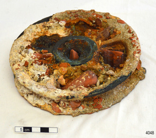
Functional object - Pulley Sheave, Russell & Co, 1888
This ship's pully sheave was part of the Antares rigging. A pulley sheave is a circle on a shaft that is manufactured to hold up movement and change of way of a cable or/and rope, or transfer of power between the shaft and cable or/and rope. A pulley is a unique mechanism that is used to leverage the lifting of heavy loads to required heights. The Italian barque Antares was an iron three-masted sailing clipper built in 1888 by Russell & Co of Port Glasgow originally named the “Sutlej” and renamed in 1907 the “Antares” when sold to the Semider Bros of Genoa Italy. The vessel left Marseilles on the 18th of December 1913 with its master captain Gazedo destined for Mullaly & Byrne of Melbourne with a cargo of roofing tiles but failed to arrive. The wreckage was found near the Bay of Islands twenty-two miles east of Warrnambool after a body had washed ashore. Some of the timbers washed up were charred by fire, and a small boat's stern board with the name "Sutlej" led to the identification of the wreck as Antares which had been reported missing. According to later reports, the Antares wrecking was overshadowed by war news at the time. A young local boy had remarked that the Germans had arrived off the coast as he had seen them firing off shells and rockets, but his story was passed off as a joke. These rockets were most likely the distress signals from the stricken ship. The Italian barque/clipper Antares was sometime later reported as overdue. The wreck of the ship was later found at the base of a cliff at the Bay of Islands near Warrnambool in November 1914, there were no survivors.The Antares is significant as it was a sail trader carrying an international inbound cargo during the early part of the 20th century. It is part of the Great Ocean Road Historic Shipwreck Trail and as such is registered as a protected wreck in the Victorian Heritage Database VHS S34.Pulley sheave; brass, with recesses full of concretion. The metal has some blue-green colouration due to exposure to sea water. Recovered from the wreak of the Antares. Noneflagstaff hill, warrnambool, flagstaff-hill-maritime-museum, shipwreck-coast, flagstaff-hill-maritime-village, pulley sheave, antares, tall ship, peterborough, 1914 shipwreck, phillip le couteur, peter mathieson, constable stainsbury, sutlej, bay of islands, pully sheave, pulley, lifting equipment -
 Federation University Historical Collection
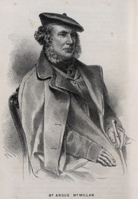
Drawing - Image - black and white, Angus McMillan, c1835
Angus McMillan named the Avon River after the river of the same name in his native Scotland. In 1840 he established a pastoral run at Bushy Park, north-west of the township. William Odell Raymond established a run in the area in 1842, and built his house, Strathfieldsaye, during 1848–54. European settlement did not take place without resistance, and in return, massacres were inflicted by Angus McMillan and others on Gunai people, especially between the years of 1840 and 1850. (wikipedia) The first application for the 'Bushy Park' run appears in the “Port Phillip Gazette” on 13 August 1843. It was taken up by Angus McMillan, who also took up the 'Boisdale' run for his employer Lachlan Macalister at the same time. In March 1844 a Licence to occupy the 16,000 acre 'Bushy Park' was granted to McMillan. In the late 1840s Andrew Martin and Matt McCraw built Angus McMillan's Bushy Park homestead. Aboriginal killings in Gippsland area most often were never formally recorded, but lived on in folklore, mainly in place names pinpointing what some historians now refer to as "massacres", and others as "conflicts". There is Boney Point, on Lake Wellington, Butchers Creek, near Metung, Slaughterhouse Gully, at Buchan, Skull Creek, at Lindenow, and, notoriously, Warrigal Creek, at Woodside. "Here, according to a couple of contemporary - though not eyewitness - reports, between 50 and 150 blacks were killed in an orgy of revenge after the murder and mutilation of a leading Scots settler, Ronald Macalister. If anybody had any doubts about the fitness of commemorating McMillan's name, no one voiced them then. Gippsland was, and still is, dotted with stone cairns tracing his route from Omeo, down the Tambo Valley to the fertile plains where he was to make (and lose) his fortune. And where, according to a growing body of opinion, he was to lead the "Highland Brigade", a band of armed settlers, against the Kurnai. History is fiction agreed on, and it is written by the winners. For most of the past 150 years, McMillan has been hailed as a trail-blazing pioneer. The legend began to crumble 20 years ago with publication of new histories, which at first outraged Gippsland historical societies and old residents, but which have gradually changed the way McMillan is viewed. ... Still, not all McMillan's contemporaries agreed with the "Highland Brigade" and its methods. Henry Meyrick, an English-born squatter, wrote to relatives in disgust about his neighbours. He estimated that 450 had been killed, and wrote: "Men, women and children are shot down whenever they can be met with. Some excuse might be found for shooting the men by those who are daily getting their cattle speared, but what they can urge in their excuse who shoot the women and children I cannot conceive." (http://www.theage.com.au/articles/2002/04/26/1019441303552.html, accessed 20 September 2016.) The Gippsland electorate is called 'McMillan' in his honour. Black and white image of a man wearing a coat and beret. He is Scottish born Victorian Squatter Angus McMillan of Bushy Park, Gippsland.angus mcmillan, squatter, aboriginal massacre, bushy park, gunai, avon river, pioneer -
 Whitehorse Historical Society Inc.
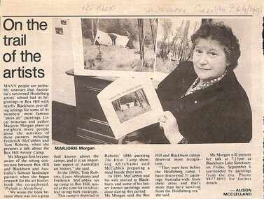
Article, On The Trail Of The Artists, 06/09/1996?
Marjorie Morgan states McCubbin and Roberts painted at least 51 paintings in Box Hill and Blackburn before establishing their Heidelberg Campnon-fictionMarjorie Morgan states McCubbin and Roberts painted at least 51 paintings in Box Hill and Blackburn before establishing their Heidelberg Campmorgan marjorie, heidelberg school -
 Eltham District Historical Society Inc
Photograph, Tess Justine (Nillumbik Shire Council), Murray's Bridge over the Diamond Creek, Eltham North, 19 Feb 2022
Murray's Bridge over the Diamond Creek on the Diamond Creek Trail just prior to demolition and replacement with a new steel bridge. Heritage advice obtained by Nillumbik Shire Council, following a suggestion by the Eltham District Historical Society (EDHS), is that the original bridge appears to have been a simplified version of the Country Roads Board’s (CRB) standard timber bridge design of the early-to-mid 1920s. In c1990 Murray’s bridge was renovated with three recycled steel girders as part of a bike/pedestrian path in the reserve. During these alterations many parts of the bridge were removed, and some were replaced. Heritage advice indicates the condition of Murray’s bridge is poor. The remaining original parts are all in poor condition, with severe weathering, splitting and rot, especially to the stringers retained on the bridge. Heritage advice is that Murray’s Bridge does not have sufficient significance in the cultural history of the Nillumbik area to warrant inclusion in the Nillumbik Shire Heritage Overlay and also does not have sufficient significance as a rare survivor to warrant inclusion in the Nillumbik Shire Heritage Overlay. There are no indications in the historical record that this site was individually important to the cultural history of this area. EDHS is comfortable with the heritage advice provided to Council and has worked closely on this project with Council. EDHS has suggested some of the removed timbers be used in the vicinity of the bridge for landscaping and possibly seating, so as to retain these remnants close to the site of the original bridge, which is the last old timber bridge along the lower reaches of the Diamond Creek. Mary (Sweeney) Murray and John Wright Murray selected 80 acres, Lot C Section 16 and Lot 5 Section 17 Parish of Nillumbik, under an occupation license in 1866. John died in 1867 and freehold was granted to his son John in 1873. The farm was known as ‘Laurel Hill’. John Junior was an Eltham Shire councillor and sometime president from 1887 up until 1897. He added Lot A Section 16 to the farm in ca1888. John and his younger brother James arranged to rent/purchase Lot B Section 17, across Diamond Creek to the west, in ca1900. It appears that John and James farmed separately for a few years, with a new homestead built for James ad family on the high point of Lot B Section 17 in ca1910. John sold off Lot 5 Section 17 in 1912. When John died in 1912 James took over the land on both sides of the Diamond Creek. The old homestead on the west side of the Creek disappeared. A farm bridge over Diamond Creek from this period may have been located close to the northern boundary of the farm. John Langlands, owner of the farm known as ‘Ihurst’ on the west side of Diamond Creek to the south of the Murray’s land, died in 1907. In 1909 his land was then subdivided into 100 lots to become the ‘Glen Park Estate’. Other similar subdivisions of nineteenth century farms around Eltham in this period included the ‘Franktonia (or Beard’s) Estate’ to the northeast and ‘Bonsack’s Estate’ between Eltham and Greensborough. Soon after the opening of the railway extension line from Eltham to Hurstbridge in 1912, Glen Park and nearby residents including James Murray agitated for a railway station or siding to be located half-way between Eltham and Hurstbridge, so that the Glen Park residents who used the railway daily did not have to walk into the Eltham or Hurstbridge stations. Some believed Coleman’s Corner (opposite Edendale Farm) was an appropriate spot for the platform. James Murray was among those who thought the railway should be located on his land, closer to half-way between Eltham and Hurstbridge stations. The Railways Commissioners warned that the locals would have to fund these works themselves. The Glen Park Estate residents initially had difficulty accessing Eltham by road, with only an old low-level bridge over Diamond Creek at the south end of their estate. A new timber trestle bridge across the creek, now on Wattletree Road, was opened in 1915. Road access to the north was gained in 1927 when the new Murray’s Road, which crossed the Murray’s land, was built. Residents continued to agitate for a Glen Park station. By 1926 the Railways Commissioners’ preferred site was on the Murray’s land. They arranged an estimate of cost of a full-length platform. The estimate was too much for the locals, who in 1928 argued unsuccessfully for a shorter and hence cheaper platform. By 1929 Murray had agreed to donate the land, but the locals would still have to fund the works. Murray decided, unilaterally it would appear, to commence work on a timber trestle road bridge over Diamond Creek to link the new Murray Road to the proposed station. Late in 1929 he stopped work on the bridge, for reasons unknown, but started work again and completed the bridge in 1931. There is no further newspaper evidence of the campaign for the Glen Park station until 1939, when Murray and another local, Mr Maxwell, met the Railways Commissioner. The Glen Park locale now included 45 homes on the west side of the creek and 20 on the Eltham side. Most of the residents used the train every day. The Commissioner remained adamant that only a full-length platform could be built for safety reasons. It appears the campaign dissolved at this point. The increasing move to cars may have had an impact. There is no evidence of Murray’s bridge ever being connected to Murray’s Road, or of it having wide use for any purpose by locals. James Murray died in 1947 and the farm was taken over by his son James (Jim). Jim started to sell off parts of the farm in the 1980s, retaining a few acres around the ca1910 homestead and building a new house there. Recreation reserves were established along the creek. In ca1990 Murray’s bridge was renovated with steel girders as part of a bike/pedestrian path in the reserve. The old farmhouse was demolished in ca2014. * * * A theory posted on local community Facebook groups was that the bridge was built in the 1860s and was built to be more robust than was necessary for the movement of cows from one side of the creek to the other. It was suggested the robustness was necessary to support the weight of gold ore being transferred from a mine on Murray’s land to a railway siding near Murrays Bridge (presumably for transfer and processing at Diamond Creek). Perhaps this may have been one of the motivators for Murray, who really knows? Knowing when mining operations ceased on his land and how that fits the overall timeline would be useful but at the time the bridge was built, local gold production was minimal at best. The known facts are: • The railway line came to Eltham in 1902. • The extension of the railway from Eltham to Hurstbridge was constructed in 1912 so no railway line even existed through Murray's property until 1912 and the Victorian Railways maps at the time show no such siding on Murray’s property. • In 1923 a new company was formed in anticipation of the old Diamond Creek Gold Mine being re-opened. The mine had been previously closed and flooded. It was noted in the press at the time that the mine was within a mile of the railway. Nothing really came of this. • Construction of Murrays Bridge was commenced by James Murray in early 1929 in anticipation of a proposed flag station being nominated on his land, but work ceased shortly afterwards. The proposed flag station was commonly referred to as Glen Park as the residents of the Glen Park Estate wanted Option 1, located near them with the platform adjacent to Colemans corner. This was probably never going to fly as it was virtually in eyesight of Eltham station. Allandale Road was the third option, but the Commissioners' preferred option was No. 2 - on Murray's property. • The Railway Commissioners were not going to finance any such station and the works had to be funded by private landowners and residents, hence Murray investing in this himself. • Murray recommenced work two years later and finished his bridge in 1931 but unfortunately for him, the proposed flag station never eventuated. The bluestone siding you reference may well have been built by Murray as part of the proposed station platform. • Up until then, apart from the Main Road bridge, which was washed away in 1924, virtually all local crossings over the Diamond Creek were low lying bridges – Kaylocks Bridge at Brougham Street, Diamond Street bridge, Glen Park Road bridge. It is expected that Murray also had a low-lying bridge to connect his land either side of the creek. These were all washed away or severely damaged multiple times in the 1920s. Lessons were learnt, and Murrays Bridge appears to have been built in accordance with Country Road Board standards of the time. Flood damage was ongoing, and even more recently constructed raised bridges kept getting washed away, e.g., the new Wattle Tree Road bridge in 1958 just months after completion. Murray’s bridge was reinforced with steel some 30 years ago presumably to provide additional floodwater resistance, given the history of bridges disappearing in floodwaters. • In March 1932 it was reported in the Advertiser that there were still some prospectors operating around Eltham North who apart from further scarring the face of the earth over the previous two years had gained significant experience but little gold - hardly a driving factor for constructing a dedicated railway siding and bridge to transfer gold ore. It is far more probable that James Murray was hoping to have the railway station located on his property and invested his money by building the bridge to lead to it as well as a station platform. Had the station eventuated, it may well have driven up the value of his land for subdivision and new housing estates like the Glen Park Estate. That did not eventuate. Whilst the bridge was indeed old (90 years), the core structure being completed in 1931, it had been modified substantially from original and hence had no significant historic value – i.e., it was not a representative example of its type, construction, and age. Given that the bridge was not worthy of saving, the Eltham District Historical Society with Council’s support, and the Eltham Woodworkers group endeavoured to see what suitable sized timbers were salvageable to fabricate a commemorative seat. Unfortunately, the experts at the Woodworkers group were unable to salvage any suitable length/width timbers to fabricate the seat due to the presence of rot. Last remaining wooden trestle bridge on the Diamond Creek Trail just prior to demolition and replacementBorn digital image (27)diamond creek (creek), diamond creek trail, murrays bridge, ‘laurel hill’, john wright murray, mary (sweeney) murra, john murray jnr, james murray, john langlands, ‘ihurst’, ‘glen park estate’, beard's estate, franktonia, bonsack's estate, glen park estate, glen park railway station -
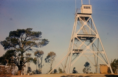 Bendigo Historical Society Inc.
Slide - Peter Ellis Collection, Kaweka Wildflower Reserve, Castlemaine, Lightning Hill Lookout Bendigo, One Tree Hill Lookout Tower Bendigo, Kamarooka Forest Area, c1970-1972
Kaweka Reserve is a a small reserve of approximately 8ha. The land was donated to the Castlemaine City to be a wildflower Reserve. A management committee was formed in 1966. The committee is still managing the park. Vicroads Edition 6: Map 59E2, 628 H4 Location. Turner St, Castlemaine. From the Castlemaine Post Office, drive north (towards Bendigo) and turn right along Turner Street to the park entrance. What to do: walk along some of the tracks through the park follow the nature trail bird watch have a picnic at the picnic tables. RUSH Dam is a basic free camping area sits alongside Rush Dam in the Greater Bendigo National Park, featuring a single picnic table and wood fire barbecue.Peter Ellis Collection: Seventeen slides of Kaweka Wildflower Reserve, Castlemaine, Lightning Hill Lookout Bendigo, One Tree Hill Lookout Tower Bendigo. Also the Rush Dam free camping area at Kamarooka. Also a slide of an unknown group having a meal or day out; perhaps also a working bee. In addition there are two slides of a house - location not specified; and a working bee clearing along a pipeline at Big Hill. Peter was a chemistry lecturer at the Bendigo Institute of technology.history, bendigo, peter ellis collection, whipstick bendigo, bendigo state forests, kaweka wildflower reserve castlemaine, one tree hill lookout bendigo, lightning hill lookout bendigo, kamarooka, rush dam kamarooka, greater bendigo national park -
 Bendigo Historical Society Inc.
Document - BARBARA MAMOUNEY COLLECTION: GOLDEN SQUARE METHODIST CHURCH PHOTOS AND DOCUMENTS
Green plastic folder with black plastic binding labelled PHOTOS RE HISTORY, opens with a list of 41 photos with their respective sizes in (inches) and (unrelated) numbers; then an A4 stapled pages re- an up-coming (Feb 27-29 2004) Cornish Families celebration, listing activities such as attending a 'meet the Cornish Concert', Festival Celebration Dinner, the Cornish Floral Dance, research one's own family history, follow the Cornish trail, Picnic in Rosalind park, and Meet the Bards of Cornwall; and buy a CD-ROM; followed by a hand-written time line or diary and business card for Harrison Print; 8 printing drafts with four names and years of birth and death; An image of some of Miss James' Sunday School Young mens' class from 1915 (photo taken at Royal Melbourne Show grounds Military camp); 9 GSUC accounts with letter-head; then an A4 off-white with Compliments card enclosing a black and white image with some names of a Golden Square Methodist Church Augustinian Fair Work-force; x2 smaller 'With Compliments' cards (one of paper) enclosing a black and white image (Circa 1860) of mines along the new Chum Line of Reef with GS Methodist Church in background; A newspaper cutting of line advertisement re- Golden Square Uniting Church celebrating 150 years of Methodism on the Goldfields citing its address and times of services; a collage of 3 black and white images dated Nov 1960 titled Church Activities; another collage of 3 slightly larger images taken around the same time of similar activities and showing numerous people around the church, and one of the pulpit; a sepia image of unidentified members of the church; fading copy of photo of Golden Square Methodist Church Choir behind which is a list of names of those in the picture though the list is dated 1960 the image looks pre-1960; handwritten list of Sunday School Teachers from 1957, no image; an A4 copy of one of the previous collage photos of outside the Church with numerous members, no names given; A4 image of GS Methodist church members, no names but minister appears 2nd row, third from left; a second copy of that image; Image of Band of Hope Conference, Bendigo, William Irving identified but undated; opportunity for naming those in image; A4 image with names and faces of Young Ladies Class of G.S.M.S.S. undated; 1/2 A4 size 'With Compliments' card enclosing as per earlier image of of Mines along New Chum Reef circa 1860; handwritten list of trustees from 1957, no image; collage of 2 images, one of previous shot of outside the church with members gathered, the other of the choir in action; copies of line ads for Bendigo Advertiser beginning with 30 July 1859 and relating to the Begelhole family and a list of Descendants of Henry William Bugelhoal / Begelhole on 3 stapled A4 typed pages, back to 1791; Another almost A4 image of the mines along the New Chum Line of Reef, with GSMC in the background; a smaller image of an unidentified marriage and Minister behind which is a larger image of the same; two versions of 1/2 A4 size 'With Compliments' cards, one of card enclosing images re- Commemorative pavers and associated memorabilia, and two women one of whom looks to be Barbara Mamouney. And one (with Comps) of paper with no image inside; a typed list of names of those in an undisclosed photo.golden square uniting church, the cornish in bendigo, list of photos (images) -
 Bendigo Historical Society Inc.
Document - PETER ELLIS COLLECTION: EMAILS TRAIL, 8th May, 1997
Copies of emails between David De Santi, Philip Ashton, and Peter Ellis regarding the making of a video. Also some notes to Mary from Jen regarding dance videos and which ones are suitable for Primary school children.clubs, music, bush dance & music club of bendigo, peter ellis collection, david de santi, graeme murray, philip ashton, abc marketing, wongawilli colonial dance club, chateau dore, nell challingsworth, alex hood, peter johnson -
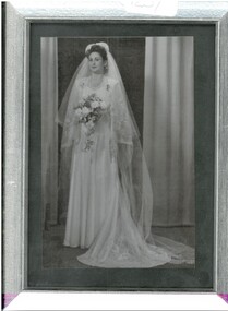 Bendigo Historical Society Inc.
Photograph - AILEEN AND JOHN ELLISON COLLECTION: FRAMED WEDDING PHOTOGRAPH OF BRIDE, 24 September 1949
Photograph. 12.5 cms x 17.5 cms, in a plain silver frame. In black and white, this photograph shows bride Aileen Beryl Ervin of McKenzie Creek, via Horsham, in her wedding attire, for her marriage to Leslie John Ellison, of McKenzie Creek via Horsham. This ceremony was officiated by Rev. Francis Fielding, on September 24th 1949, in the Horsham Methodist Church. The bride wore a beautiful gown, with a short and a long veil. Her flowers trail beautifully and she appears to be holding some horseshoes over her left arm.photograph, person, photograph of bride.