Showing 270 items
matching stawell map
-
 Stawell Historical Society Inc
Photograph, Stop Press Treasures Uncovered
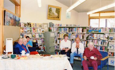
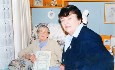
7151: A GROUP OF PEOPLE IN THE LIBRARY. 7151-1: TWO PEOPLE, THE MAN FACING LEFT THE WOMAN FACING RIGHT LOOKING AT A MAP. 7151-2: TWO PEOPLE STANDING IN FRONT OF A FAMILY HISTORY, READING A PAGE IN PLASTIC SLIP COVER. 7151-3 SIMILAR TO PREVIOUS BUT SHOWING PAGE TO CAMERA. 7151-4 A WOMAN STANDING IN FRONT OF PLASTIC CONTAINER. 7151-5 SIMILAR TO PREVIOUS BUT HOLDING A PIECE OF PAPER. 7151-6 SIX PEOPLE SITTING DOWN, THREE ON RIGHT, THREE ON LEFT. 7151-7: TWO WOMEN ON SITTING HOLING A CERTIFICATE.7151-1, 7151-4,7151-5 'Stop Press Treasures Uncovered' Stop Press in Redbiarri -
 Stawell Historical Society Inc
Photograph, Stop Press Treasures Uncovered
7151: A GROUP OF PEOPLE IN THE LIBRARY. 7151-1: TWO PEOPLE, THE MAN FACING LEFT THE WOMAN FACING RIGHT LOOKING AT A MAP. 7151-2: TWO PEOPLE STANDING IN FRONT OF A FAMILY HISTORY, READING A PAGE IN PLASTIC SLIP COVER. 7151-3 SIMILAR TO PREVIOUS BUT SHOWING PAGE TO CAMERA. 7151-4 A WOMAN STANDING IN FRONT OF PLASTIC CONTAINER. 7151-5 SIMILAR TO PREVIOUS BUT HOLDING A PIECE OF PAPER. 7151-6 SIX PEOPLE SITTING DOWN, THREE ON RIGHT, THREE ON LEFT. 7151-7: TWO WOMEN ON SITTING HOLING A CERTIFICATE.7151-1, 7151-4,7151-5 'Stop Press Treasures Uncovered' Stop Press in Redbiarri -
 Stawell Historical Society Inc
Book, Family Record of Johann Gottfried Hoffmann 1849-1979
Family History of Hoffmann Compiled by Heinrich Hoffmann, Otto Hoffmann and Lila LockwoodBlue Booklet with Blue Print on front with map of AustraliaStamped in front cover Bruce Dudonfamily history -
Stawell Historical Society Inc
Map - Drawings, Wendy Jacobs, Western Highway Community Precinct Development Structural Drawings, 2014
501 Slab and Footing Plan. 502 Slab and Footing Details. 505 Roof Framing Plan 506 Steel Framing Elevations - Sheet 1. 507 Steel Framing Elevations and Sections - Sheet 2 508 Steel Framing Details - Sheet 1 509 Steel Framing Details - Sheet 2 SN1 General Notes, Site map & Drawing Index Used in building Historical Society Building Eight (8) A1 Printed plans Structural DrwaingsWendy Jacobs Architect & Heritage consultant may 2014 -
Stawell Historical Society Inc
Map - Drawings, Wendy Jacobs, Wester Highway Community Precinct Development Hydrolic Services, 2014
Used in Building Historical Society BuildingTwo (2) A1 Printed Plans Hydrolic ServicesDrawing No. H100 Rev C1 July 2014. Drawing No. H101 Rev C1 July 2014 -
Stawell Historical Society Inc
Map - Drawings, Wendy Jacobs, Western Highway, 2014
WD 1/13 - Site Plan WD 2/13 - Existing Conditions & Demolition Plan WD 3/13 - Floor Plan WD 4/13 - Elevations WD 5/13 - Sections AA & BB WD 6/13 - Sections CC WD 7/13 - Sections DD, EE & FF WD 9/13 - Roof Plan WD 10 /13 Reflected Ceiling Plan WD 12/13 - Toilet & Meeting Cup'd Details WD 13/13 - DetailsEleven (11) A1 Printed MapsWendy Jacobs Architect & Heritage Consultant Nov 2014 -
Stawell Historical Society Inc
Map - Electoral Map, Federal Government, map of Commonwealth Electoral Division of Wimmera 1949, 1949
... Stawell Historical Society Inc 46 Longfield St Stawell ...Electoral MapMap overprinted with Electoral Divisions in Red. Description of Division of Wimmera Scale in Miles. Commonwealth of Australia State of Victoriagovernment -
Stawell Historical Society Inc
Map, R.O. Robson - Authorised Surveyor, Road from Glenorchy to near Geary's Selection Callawaddy 1880, 29.04.1880
... Stawell 29.04.80 Cloth Backed Map. Plan of Road. Road from ...Survey for Road CreationCloth Backed Map. Plan of Road.Parishes of Richella & Callawadda. County of Borong. Plan of Road. R.O. Robson Authorised Surveyor Stawell 29.04.80 -
Stawell Historical Society Inc
Map - Parish Map, Barkley County of Kara Kara 1920's, 1920's ?
Johnsons Gully LeadPaper map of Parish of BarkelyBy Authority H.J. Green Govt Printer. Photo Lithographed at the Department of Lands and Survey. Melbourne 22.11.2survey -
Stawell Historical Society Inc
Map, Crowlands & Navarre Railway Construction Trust, VR Plan Showing Railway Construction District Crowlands to navarre Line 1916, 4 July 1916
Two (2) Very large Coloured Maps. Scale 40 Chains to 1 Inch. rail Line Drawn in RedShire of Kara Kara. Shire of Stawell Shire of Ararat 4 July 1916railways -
Stawell Historical Society Inc
Map, Fred W Wright Surveyor, Plan of the Borough of Stawell showing Mining leases & reefs 1870, 1870
Mining details. Including Tramways, Water Races. Crushing Mills. Reefs and Reserves.Copy of Original Showing Stawell Borough with details including mining leases Companies and MillsInsert with details of Sections 23, 34, 35 & 36. Fred W Wright 12 May 1870mining -
Stawell Historical Society Inc
Map, W.J. Butson, Subdivision of North Woodlands Estate 1922, 12.02.1922
Two (2) Copies. A1 Maps with Cloth Backing Annotated with Title HoldersParishes of Malkaff & Navarre County of Kara Kara Photlithograph by W.J Butson 12.02.2022farming -
Stawell Historical Society Inc
Map, Rupunyup and Marnoo Railway Construction District 1900, 11/06/1908
... Stawell Historical Society Inc 46 Longfield St Stawell ...Map Shows Rail Lines. Glenorchy Lubeck Rupunyup Marnoo Murtoa MinyipMap Showing line to be Constructed from Rupunyup to Newall's Corner Marnoo.Marnoo Railway Trustrailways -
Stawell Historical Society Inc
Map, The Litho Co Ballarat, Glyntowyn Estate Campbells Bridge 1909, 1909
Shows Hoestead CC McCulloch ESQPaper map / Poster Advertising Subdivision of EstateMitchell Bros & White. 5003 Acres The Litho Co Ballarat Black Printing with Red Coloured Sectionsfarming -
Stawell Historical Society Inc
Map, Lexington County of Borong 1910, 1910
Parish to the North East of MoystonA2 Parish mapPhoto Lithographed at the Department of Lands and Survey. Melbourne by T.F. McGauran 5.12.10survey -
Stawell Historical Society Inc
Map, T.F. McGauran, William Couty of Borong 1891, 1891
... A2 Parish Map of Willam Inculdin Stawell Water Supply... Map of Willam Inculdin Stawell Water Supply Reserve and Creeks ...Stawell Water Supply Reserve. Grampians State Forest. Dairy Creek, Fyans Creek, Barney's Creek, Bovine Creek, Glasstree Creek, Stoney Creek. Stawell Water Supply Aquaduct Fkuming Tunnel.A2 Parish Map of Willam Inculdin Stawell Water Supply Reserve and Creeks. Marked in redPhoto Lithographed at the Department of Lands and Survey Melbourne. By T.F. McGauran 20.07.91 water supply survey -
Stawell Historical Society Inc
Map, T.F. McGauran, Winjallock County of Kara Kara, 1900
Noth of Navarre and BarkleyA2 Map0f Parish of Kara Kara.Photo Lithographed and the department of Lands & Survey, Melbourne by T.F. McCauran 22.10.00survey -
Stawell Historical Society Inc
Map - Parish Map, Department of Lands and Survey, Ashens County of Borung 1941, 1941
Murtoa Lake MarmaPaper Brown Coloured MapDrawn and Reproduced at the department of Lands and Survey Melbourne 1.5.1941survey -
Stawell Historical Society Inc
Map, Department of Crown Lands and Survey Victoria, Allotments in the Township of Banyana. Parish of Burrum Burrum. 1946 / 1971, 1971
Richardson River. Avon River JunctionPaper Map of County of BorungReprint of the 1946 edition. Drawn and reproduced at the Department of Crown Lands and Survey Victoria 1971.survey -
Stawell Historical Society Inc
Map, Department of Lands & Survey J. Noone, Township of Heatherlie. Parish of Baroka. County of Borung 1888, 1888
Stawell & Grampians Freestone Quarry Company Railway Reserve. Cross & masons Quarry Site. Mamnager'sHouse, Stead's boarding House Stawell and Grampians railwaySurveyed Township Showing Quarry and railway Reservephoto Lithographed at the Department of lands and Survey Melbourne By J Noone 15.6.88railway quarry -
Stawell Historical Society Inc
Map - Plan, Earle and Partners, Restoration of Pleasant Creek Courthouse Stawell West 1974, 24/10/1974
... Stawell Historical Society Inc 46 Longfield St Stawell ...Drawing 1 Is not in Collection Drawing 5 Landscape Pal is 5092-13 A2 Sheets. Drawing 3 is Elevations. Drawing 2 is Gallery And Roof Plan. Drawing 4 Details24 Oct 74. And 25 Oct 74stawell historical -
Stawell Historical Society Inc
Map - Plan, Earle and Partners, Restoration of Pleasant Creek Courthouse Stawell West 1975, 4/8/1975
... Stawell West 1975 Map Plan Earle and Partners ...Designs for Restoration. Includes details for Public Toilet & Trees.A1 Plan of PrecinctDrawing No. 5 4.8.1975. Pleasant Creek Court of Petty Sessions Built in 1860. Museumstawell historical -
Stawell Historical Society Inc
Map, Stawell Gold Mines, Stawell Township proposed Town zoning showing Special Uses ( Mining) 1998, 1998
... ( Mining) 1998 Map Stawell Gold Mines ...Shows Mining activity Stockpiles Tracks, Plant, Dams, Waste heap, Tailing Dams, IronbarksMap Printed in Colour with Coloured LegendStawell Gold Mines Pty Ltd Date April 1998mining -
Stawell Historical Society Inc
Map, Plan of Division Line between Ararat and Stawell Shires 1877, 1877
... Stawell Historical Society Inc 46 Longfield St Stawell ...Grampians Halls Gap Black Range Stawell Shire Ararat Shire Crowlands TownshipVery Large Map Printed on Linen with Table of bearingsExamined by H.C. Malcolm 28.12.77 Traced By D.H. Meike 28.12.77survey -
Stawell Historical Society Inc
Book - Country Fire Authority, Region 17 Rural Directory 2nd Edition 1990
... Stawell Historical Society Inc 46 Longfield St Stawell ...Maps for use of C.F.A.Bound Plastic Cover over pale green soft cover with CFA Logo. green & white zebra crossing.Country Fire Authority Region17 Rural Directory 2nd Edition 1990. Published by the C.F.A. Mapping Association Inc. Sold by same, at R 17 H.Q. 119 Firebrace Street Horsham Firebrace 3400. -
Stawell Historical Society Inc
Book - Science, The Natural History of Western Victoria, 1974
Reports from Symposium of Australian Insitutes of Agricultural Science, held in Horsham 1971. 8 chapters, 7 of science 8th extracts from Stapylton's Journal of Western Victoria, when travlling with Major Mitchell. Contains fold out Maps & photos. 1) Geology & Geomorphology 2) Soils 3) Vegitation 4) Birds 6) Aborigines 7) the first hundred years of agricultural development 8) The Journal of Granville William Chetwynd StapyltonSoft Yellow Cover and Black with Black taped spineBarry Clugston -
Stawell Historical Society Inc
Book - Report, Grampians: A Report on recreation and Timber Uses of. Too Steep to Graze - Too Rocky to Plough, 1979
1) Conservation & Economics 2) Grampians Study Area 3) Land Use 4) Management 5) Criticisms of the Management Plan Appendix Graphs & MapsGreen Paper cover: Black tape on SpineConservation council of Victoria and Logo -
Stawell Historical Society Inc
Book - Report, Shire of Stawell, Local Conservation Strategy, 1990
Photos of Steering Committee and Support Staff. Shire Map Photos, Maps.Grey Cardboard cover with Shire LogoBarry Clugston Shire of Stawell with Logo - Local Conservation Strategy -
Stawell Historical Society Inc
Book - Research, Black Range
Families and settlements of Black Range - Newspaper articles, Memories of families, maps, Black range School recordsGreen 2 ring Binder. Paper in plastic insertsBlack Range -
 Stawell Historical Society Inc
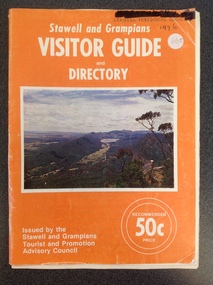
Book, Forests Commission, Stawell & Grampians Visitor Guide & Directory 1976, 1976
Tourist Brochure for Stawell and Grampians Region. Included is a Map Titled Grampain's Wonderland Forest ParkOrange Paper cover with white Print Middle of cover is a colour Picture of the Grampians.Stawell and Grampians VISITOR GUIDE and Directory. On teh Bottom right. Issued by the Stawell and Grampians Tourist Promotion Advisory Council . On the Left in two White circles "Recommended 50c Price."stawell tourism