Showing 289 items
matching steep
-
 Lakes Entrance Historical Society
Postcard, Bulmer H D, 1920c
Black and white copy same sizeTinted postcard of a bend in the Princes Highway, Jemmys Point. It shows the road between the steep cutting and post and rail fence. Glimpse of footbridge to Bullock Island, entrance and hummocks. Lakes Entrance VictoriaPrinces Highway, Lakes Entrance topography, waterways, roads and streets -
 Lakes Entrance Historical Society
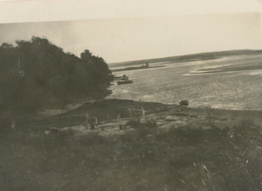
Postcard - Postcard/Cross Landing, 1910c
Paired with image 03733.1 for display at 150 years Lakes Entrance 1858 to 2008 held in October 2008Black and white postcard of lake foreshore at Cross Landing showing framework for drying fishing nets near shoreline jetties over water near steep shoreline in distance Lake Tyers Victoriaocean, topography, fishing industry -
 Lakes Entrance Historical Society
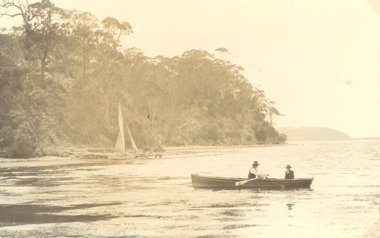
Postcard, Harpers Bight, Jemmys Point Gippsland Lakes Victoria, 1920 c
Sepia toned postcard of two males rowing a boat off Cliffcrest jetty Harpers Bight. Steep wooded cliffs beside lake distant view of Jemmys Point Gippsland Lakes Victoriajetties, buildings, roads and streets -
 Lakes Entrance Historical Society
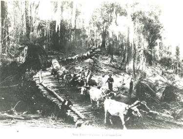
Photograph - two bullock teams , Tambo Crossing Victoria, 1900
Black and white photograph of two bullock teams and drivers hauling large logs down a steep bush track first team crossing a log bridge, man on bridge, Tambo Crossing VictoriaNear Tambo Crossing East Gippslandaccommodation, hotels, transport -
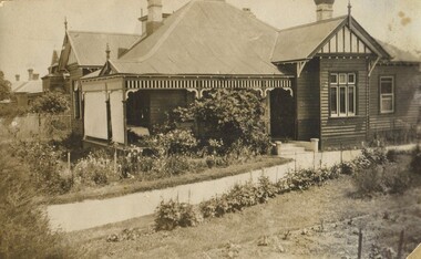 Surrey Hills Historical Society Collection
Photograph, 10 Pembroke Street, Surrey Hills, 1904
‘Eignbrook’, 10 Pembroke Street was built in 1904. It was the home of William Valentine Hill, journalist, who came to this home with his wife Annie (nee Boak) and family of eight children in 1904. Courtesy: Mr William (Bill) Dempsey, grandson of William Valentine Hill.Original sepia photograph of 10 Pembroke Street. A weatherboard house in the Queen Anne style with a steep pitched iron roof. Decorative fretwork adorns the verandah. Mounted on white cardboard and taped on 1 corner.Back of photo is inscribed “Hills House, 10 Pembroke St, Surrey Hills”. Card has written underneath the photo, “10 Pembroke St”pembroke street, surrey hills, hills family, 'eignbrook', house names, (mr) william valentine hill, (mrs) annie hill, (miss) annie boak, (mr) william (bill) demspey, journalist, queen anne style -
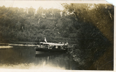 Lakes Entrance Historical Society
Postcard - MV Blackbird, Bulmers Studio, 1940
Four black and white small format postcards 6 x 8.5cm, slightly different view of the boat coming down the waterway.Black and white small format postcard showing Peels Tourist Ferry MV Blackbird leaving Comer's North Arm Jetty. Steep wooded banks, reeds along the shore. Lakes Entrance VictoriaNorth Arm Launch Trip, Lakes Entrance (on reverse)waterways, restaurant, boats and boating, tourism -
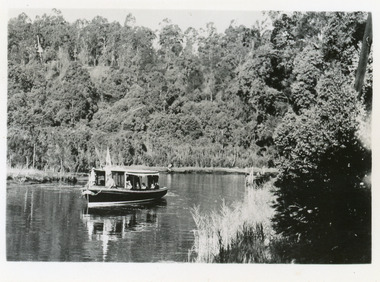 Lakes Entrance Historical Society
Postcard - MV Blackbird, Bulmers Studio, 1940
Black and white small format postcard showing Peels Tourist Ferry MV Blackbird leaving Comer's North Arm Jetty. Steep wooded banks, reeds along the shore. Lakes Entrance VictoriaNorth Arm Launch Trip, Lakes Entrance (on reverse)waterways, restaurant, boats and boating, tourism -
 Lakes Entrance Historical Society
Photograph - North Arm, 1924c
Black and white photograph of part of the North Arm. It shows the calm waters beneath steep heavily wooded banks. Some dead trees appear to have been ring barked. Lakes Entrance Victoriavegetation, waterways -
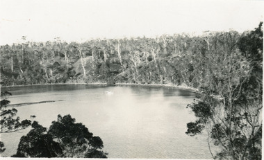
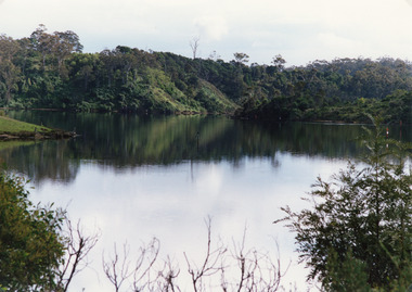 Lakes Entrance Historical Society
Photograph - North Arm, Tambo Shire, 1990c
Second copy image identical 20.5 x 28.5Colour photograph of a bay in the North Arm. It shows the calm waters of the lake surrounded by steep wooded banks, a grassy point with remains of fence or jetty. Reflections of surrounding vegetation in water. Lakes Entrance Victoria waterways, topography -
 Lakes Entrance Historical Society
Postcard - The Narrows, 1930c
Black and white small format postcard of a steamer in the Narrows, Rigby Island opposite the steep shoreline of the mainland, Reeve's Channel, Fraser Island and Flannagan Island in distance, Gippsland Lakes, Lakes Entrance Victoria.islands, waterways, topography -
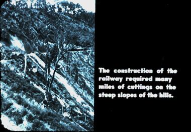 Bendigo Historical Society Inc.
Slide - DIGGERS & MINING. DIGGERS AND MINERS, c1800s
Diggers & Mining. Diggers and Miners. The construction of the railway required many miles of cuttings on the steep slopes of the hills. Photo shows that the hills are approx. 45 degrees. Markings: 24 994.5 WAL. Used as a teaching aid.hanimounteducation, tertiary, goldfields -
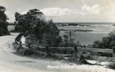
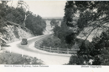
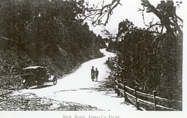 Lakes Entrance Historical Society
Photograph - Princes Highway Lakes Entrance, 1920c
Black and white photograph of the newly formed Princes Highway. It shows the steep cutting into the Jemmys Point hill, the winding road, the post and rail fence, two people and car of the era on road. Lakes Entrance VictoriaNew Road Jemmy's Pointtopography, waterways, roads and streets, fences -
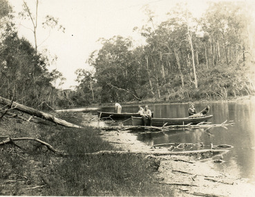 Lakes Entrance Historical Society
Photograph - North Arm, 1950c
Black and white photograph of the narrow upper reaches of the North Arm. It shows four people and dog at two small boats on bank. Steep tree covered hillsides above sandy shoreline. Lakes Entrance Victoria vegetation, waterways, recreation -
 Lakes Entrance Historical Society
Photograph - Reeves Channel, Fraser, Ian, 1995c
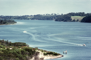
Colour photograph of Reeves Channel of Lake King, Gippsland Lakes. It shows part of both Rigby Island and Fraser Island opposite the steep shoreline of the mainland. Two motor boats on lake. Lakes Entrance Victoriaislands, waterways, topography -
 Orbost & District Historical Society
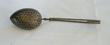
tea infuser, first half 20th century?
A tea infuser is a device in which loose, dried tea leaves are placed for steeping or brewing. The tea infuser gained popularity in the first half of the 19th century. This item is an example of a commonly used kitchen utensil not in common use today. It has been superseded by the teabag.A tea infuser spoon which looks like a small covered spoon. It is made from metal (brass?) with small holes. It has a narrow tapered handle.tea-infuser beverages kitchenware -
 Flagstaff Hill Maritime Museum and Village
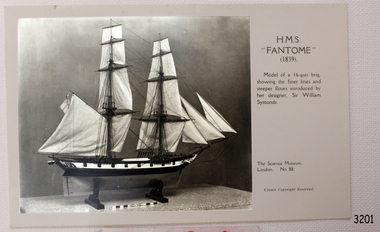
Postcard
Black and White Postcard of H.M.S. Fantome (1839). Model of a 16-gun brig, showing the finer lines and steeper floors introduced by her designer, Sir William Symonds. (SH 090[2] Ships F - H).flagstaff hill, warrnambool, shipwrecked-coast, flagstaff-hill, flagstaff-hill-maritime-museum, maritime-museum, shipwreck-coast, flagstaff-hill-maritime-village, h.m.s. fantome, sir william symonds, post card, postcard -
 Bendigo Historical Society Inc.
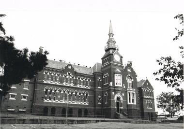
Photograph - LA TROBE UNIVERSITY BENDIGO COLLECTION: CAMP HILL PRIMARY SCHOOL
A black and white photograph of Camp Hill Primary School above Rosalind Park. This is a brick building with arches and quoins, tall lancet windows and steep slated roofs. It has a tower with a balcony, a fire-brigade lookout and a steeple.bendigo, education, camp hill primary school, la trobe university bendigo collection, collection, bendigo, education, tertiary education, primary schools, state schools, bendigo teachers' college, buildings, schools, central state school, camp hill primary school -
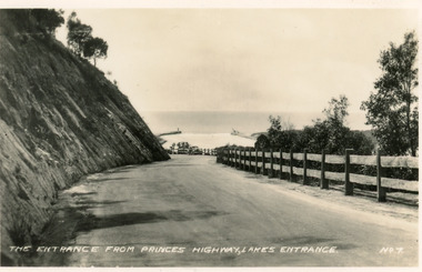 Lakes Entrance Historical Society
Postcard - Princes Highway Lakes Entrance, Valentine Series, 1940c
Black and white small format postcard of the Princes Highway at Kalimna Hill The road winds between the steep road cutting and a post & rail guard fence. In the distance is the artificial entrance to the Gippsland Lakes. Lakes Entrance VictoriaThe entrance from Princes Highway, Lakes Entranceroads and streets, fences -
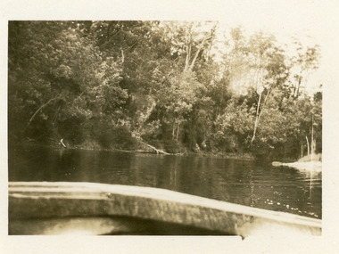 Lakes Entrance Historical Society
Photograph - Comer's Landing
Black and white photograph of the North Arm at Comer's Landing, North Arm, showing a tree covered steep bank opposite Mrs Comer's Tea Rooms, viewed over the back of a tourist launch. Lakes Entrance Victoriarestaurant, tourism, waterways -
 Flagstaff Hill Maritime Museum and Village
Photograph - Historical, Flagstaff Hill, John Lindsay, View of the Bay from the south boundary of the Ports and Harbours land, 1970s
The photograph shows the view of the shore and Lady Bay with the Breakwater and Middle Island all visible. It was taken to show that the Flagstaff Hill area was unlikely to have any further development between it and the Bay, with the view of development of the Flagstaff Hill Maritime Museum and Village. This photograph, a print, is one of a set of five that show the site of Flagstaff Hill. The photographer was John Lindsay, Founding Director of Flagstaff Hill Maritime Museum and Village, with the words "Photo J Lindsay" on the back. It was taken in the early 1970s during the initial stages of the development of Flagstaff Hill as a Museum and Maritime Village. The photographs belonged to the donor's grandparents, who lived in the Warrnambool district of Allansford/Naringal. The photograph is a record of the site and surrounds of Flagstaff Hill Maritime Museum and Village before its development and opening in 1975. It shows the Surfside Holiday Park, Surf Lifesaving Club, and the Breakwater. The photograph is significant for recording the location and condition of the Lower Lighthouse on the Hill.Coloured photograph, glassy print, one of a set of five. Flagstaff Hill's Lower Lighthouse is in the foreground above the Surfside Holiday Park. To the right of centre is the Surf Lifesaving Club. In the background is Lady Bay and the Breakwater and Middle Island, with the Southern Ocean the other side. The photograph's paper has the printer's watermark and a pencilled inscription on the back. The early 1970s scene was photographed by John Lindsay, Warrnambool.Label on the back: "VIEW OF THE BAY FROM the southern boundary of the Ports and Harbours land. No development below this area is likely to obstruct the view, due to the steep grade down to the Southern boundary of Flagstaff Hill property." Handwritten in pencil: "Photo J Lindsay"flagstaff hill, flagstaff hill maritime museum and village, warrnambool, maritime museum, maritime village, great ocean road, shipwreck coast, 1970s, photograph, surfside holiday park, lady bay, flagstaff hill site, john lindsay, lower lighthouse, lower light, surf lifesaving club, breakwater, middle island, ports and harbours -
 Hume City Civic Collection
Photograph, 1990-1999
Two viaduct bridges were constructed across the Jacksons Creek valley at Rupertswood on the Bendigo rail line to bring the trains down the steep incline into Sunbury station.A photograph of the railway viaduct bridge showing one end of the span and 4 of the pylons. This bridge crosses the Jackson's Creek near one of the waterfalls which have been constructed in the creek. A large tree trunk is in the foreground of the photograph.rupertswood, clarke, william (sir), rupert (sir), michael (sir), victorian railways, salesian college, railways, bridges, jacksons creek, sunbury railway station, sunbury, george evans collection -
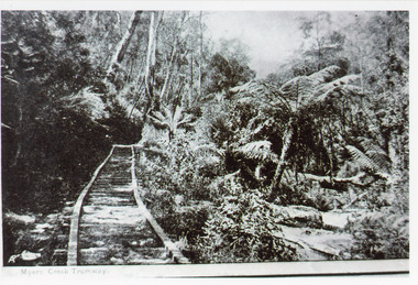 Lakes Entrance Historical Society
Photograph - Tramline, 1925
Rock obtained for works at the Entrance and around Gippsland Lakes.Black and white photograph of a tramway through bushland, steep bank above tramline, tree fern gully below. Tramway connected quarry to landing on Mississippi Creek, Colquhoun Forest north of Lakes Entrance. East Gippsland VictoriaMyer's Creek Tramwayvegetation, transport, room display -
 Lakes Entrance Historical Society
Postcard - Princes Highway Kalimna, Bulmer H D, 1935c
Black and white postcard of the Princes Highway as it winds around Jemmys Point. A motor car driving up the hill between steep road cutting and post and rail fence. View of the lake and ocean in the distance. Lakes Entrance VictoriaBend in Princes Highway, Lakes Entrance fences, roads and streets -
 Lakes Entrance Historical Society
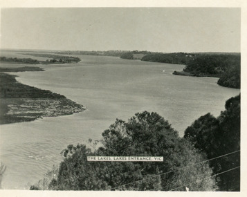
Postcard - Reeves Channel, Valentine Series, 1930c
Other copy similar view with inscription 'The Lakes, Lakes Entrance Vic'Black and white postcard of Reeves Channel Gippsland Lakes, showing Rigby, Fraser and Flannagan Islands opposite the steep shoreline of the mainland. Natural vegetation of Jemmys Point in foreground from which photograph was taken. Lakes Entrance VictoriaKalimna from Jemmys Point Lakes Entranceislands, waterways, topography -
 Lakes Entrance Historical Society
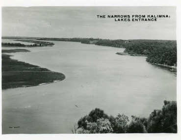
Postcard - The Narrows, Bulmer H D, 1945c
Also two other copies 6.5 x 8.5Black and white small format postcard of the Narrows, and Reeves Channel of Lake King, Gippsland Lakes, showing Rigby, Fraser and Flannagan Islands opposite the steep shoreline of the mainland. Taken from Jemmys Point. Lakes Entrance VictoriaThe Narrows from Kalimna Lakes Entranceislands, waterways -
 Surrey Hills Historical Society Collection
Photograph, 10 Pembroke Street, Surrey Hills
‘Eignbrook’ at 10 Pembroke Street was built 1904. Until the 1950s this area was the highest spot in the metropolitan area and ships in the Bay could be seen from ground level and views extended almost 360 degrees. A number of homes of this Edwardian period had viewing towers, the one in the photo being that of ‘Maroondah’ at 12 Pembroke Street. Photo taken by W V Hill. Courtesy: Mr William (Bill) Dempsey. Original sepia photograph of a weatherboard home in the Queen Anne style. It has a steep pitched iron roof. It has a woven wire fence across the front of the property and decorative gates. Mounted on white cardboard photo taped on 2 corners.Back of photo is inscribed “Hills, 10 Pembroke St, Surrey Hills”. Card has written underneath the photo, “10 Pembroke St, Home of Hills family, built 1904”pembroke street, house names, surrey hills, hills family, 'maroondah', 'eignbrook', (mr) w v hill, (mr) william (bill) dempsey, journalist, queen anne style, (mrs) annie hill -
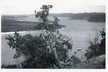 Lakes Entrance Historical Society
Photograph - Reeves Channel, 1915c
Original in possession of descendant of Arthur Seagrove, teacher at Johnsonville School 1920c.Black and white photograph of Reeves Channel, Gippsland Lakes, showing a launch in the Narrows below Jemmys Point, Rigby Island and a distant view of Fraser Island and Flannagan Island opposite the steep cliffs of the mainland shore. Lakes Entrance Victoria'To Rit with love from Arthur' on backislands, waterways, topography -
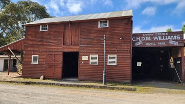 Old Gippstown
Building - Livery Stable
Used by general carriers in Warragul from the late 1880sA large, two-storey stables of timber with a corrugated iron roof. Internally there are four horse stalls on the ground floor and a loft above. The loft is accessed via steep internal stairs and a trapdoor, with an outside door and hoist point. Build in the 1880s warragul, general carriers, stables, old gippstown, west gippsland, gippsland, gippsland heritage park, goldfields, coal mine, victorian era, moe, historical village, baw baw shire, transport, latrobe valley, old gippstown heritage park, latrobe city council -
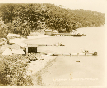 Lakes Entrance Historical Society
Postcard - Kalimna Jetty, 1920c
also identical print, poor quality 7 x 8.5|also black and white 10 x 12.5|also copy sepia tone 10 x 15|also poor quality black and white 12.5 x 17.5Black and white small format postcard of three jetties at Kalimna Gippsland Lakes Victoria. It shows tents of campers on lake edge, steep cliffs in background, small boats at jetties, person fishing from jetty. Lakes Entrance VictoriaKalimna Lakes Entrance jetties, waterways, boats and boating -
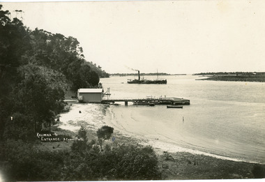 Lakes Entrance Historical Society
Postcard - Kalimna Jetty, Cooper Alexander, 1915c
Black and white large format postcard of Kalimna Jetty Gippsland Lakes. It shows the shed on the approach to the jetty and landing, Rigby Island and Entrance in background, steep cliffs at eastern edge of lake. Pioneer Dredge in channel. Lakes Entrance VictoriaKalimna and Entrancejetties, boats and boating, dredges